TrainWeb.org Facebook Page
Old Main Line Photo Tour


B&O Old Main Line
OML photo quiz #1 answers

Click a photo to see a larger view. Please send your comments and corrections to Steve.

Scoring: one point for each location correctly identified.

quiz1

#1 B&O Museum
Mile: 0.6 Date: May 2002
Ease: B View: NW
Area: B IC2:
Map: Ba 42 H 2 Topographic Maps

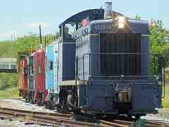
At the B&O Museum at Baltimore, B&O 633, an EMD model SW900 switcher, totes a row of cabooses (cabeese?) filled with railfans during one of the museum's All Aboard Days.

Comparable tour pic


quiz2

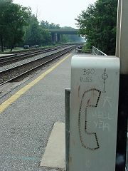
#2 St. Denis
Mile: 6.8 Date: Jul 2004
Ease: A View: E
Area: B IC2:
Map: Ba 41 J 12 Topographic Maps

CPLs 4Ever! At the platform of St. Denis station, railfan graffiti graces a telephone enclosure.

Comparable tour pic


quiz3

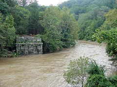
#3 Patterson Viaduct
Mile: 10.7 Date: Sep 2003
Ease: B View: SE
Area: B IC2:
Map: Ho 13 B 13 Topographic Maps

The remains of the Patterson Viaduct in Ilchester stand by cautiously as yet another muddy freshet pours down the Patapsco River courtesy Hurricane Isabel.

Comparable tour pic


quiz4

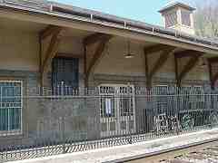
#4 Ellicott Mills
Mile: 12.8 Date: Apr 2001
Ease: A View: NW
Area: A IC2:
Map: Ho 12 G 9 Topographic Maps

Ellicott City station is under new management: the B&O RR Museum in Baltimore assumed control in December 2005. Will railfan excursion trains follow? Stay tuned.

Comparable tour pic


quiz5

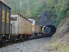
#5 Dorsey Tunnel
Mile: 19.0 Date: Oct 2004
Ease: D+ View: W
Area: A IC2:
Map: Ba 31 K 8 Topographic Maps

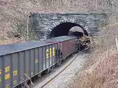
A muddy, post-freak-autumn-hailstorm trek to Dorsey Tunnel helped me catch CSX and UP locos lifting coal empties back to the mines.

This resembles Union Dam Tunnel, but can be distinguished by the gentler curve here.

Comparable tour pic


quiz6

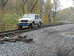
#6 Woodbine
Mile: 34.2 Date: Oct 2004
Ease: A View: SW
Area: A IC2:
Map: Ca 33 G 4, Ho 3 G 5 Topographic Maps

A track inspector just west of Woodbine drives past a rarely used switch to a rarely used short siding.

Comparable tour pic


quiz7

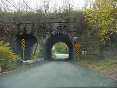
#7 Twin Arch Bridge
Mile: 38.4 Date: Oct 2004
Ease: A View: S
Area: A IC2:
Map: Ca 32 F 5, Ho 2 F 6 Topographic Maps

The one-of-a-kind Twin Arch Bridge near Mt. Airy.

Comparable tour pic


quiz8

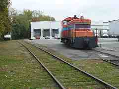
#8 Cold Storage
Mile: 40.0 Date: Oct 2004
Ease: A View: E
Area: A IC2:
Map: Fr 33 C 12, Ca 32 C 1 Topographic Maps

Mt. Airy Cold Storage's orange-painted switcher is unforgettable once you've seen it.

Comparable tour pic


quiz9

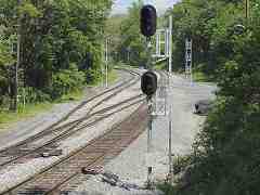
#9 Mt. Airy Junction
Mile: 41.2 Date: May 2005
Ease: B View: E
Area: B IC2:
Map: Fr 41 J 2, Ho 1 J 5 Topographic Maps

At Mt. Airy Junction, the Mt. Airy Loop and the Old Main connect.

Comparable tour pic


quiz10

#10 Hartman Tunnel
Mile: 50.8 Date: Mar 2005
Ease: C+ View: E
Area: A IC2:
Map: Fr 39 F 2 Topographic Maps

Coal rumbles through the gently curved Hartman Tunnel just west of Ijamsville.

Comparable tour pic


Award yourself one bonus point if you had realized all the photos are in westbound order.

Total your points, and find your self-scoring category:
11 pts: we're not worthy!
9 or 10 pts: Rail Baron
7 or 8 pts: Old Whiskers
5 or 6 pts: Roadmaster
3 or 4 pts: Engineer
1 or 2 pts: Flagman
0 pts: Trainee

Thanks for trying this quiz!

Return to main page


Copyright Notice