TrainWeb.org Facebook Page
Old Main Line Photo Tour


B&O Old Main Line
Modern day photo tour

Accompanying each photo below are:

Click a photo to see a larger view. Please send your comments and corrections to Steve.


<< Previous (east) | THIS PAGE: Ellicott City to Union Dam | Next (west) >>

Ellicott Mill
Photo courtesy HH Harwood collection

Ellicott Mill
Mile: 12.6 Date: 1941
Ease: B+ View: NE
Area: B+ IC2: 204
Map: Ho 12 G 10 Topographic Maps

In exchange for land, B&O promised to build a connection to the Ellicott brothers' mill on the Baltimore county side of the river. The flour mill at this location was one of B&O's earliest and best customers. Until ceasing during 2019, grain had been processed at this site since before the American Revolution. As of 2020, discussions were underway to determine what will happen at the site, one candidate being redevelopment for housing or mixed use.

Links: 1972, 1984


Patapsco Branch

Patapsco Branch
Mile: 12.7 Date: Mar 2000
Ease: A- View: SE
Area: B+ IC2: 204
Map: Ho 12 G 10 Topographic Maps

This bridge to the flour mill at Ellicott City hasn't seen a train since the 1980s, but still looks serviceable. B&O thought this substantial enough to assign to its own branch. After some work, perhaps it could be used as part of a turnaround wye if passeneger or tourist trains ever again visit Ellicott City.

A few decades ago, the plant was operated by the Doughnut Corporation of America.


Ellicott City

Ellicott City
Mile: 12.8 Date: Oct 1999
Ease: A View: N
Area: A IC2: 131
Map: Ho 12 G 9 Topographic Maps

CSX 249 is about to pass in front of the the oldest railroad station in the US. The station at Ellicott's Mills (now Ellicott City), Maryland saw its first train on May 24, 1830.

Links: 1905, 1970, 1984


Ellicott City

Ellicott City
Mile: 12.8 Date: Dec 2000
Ease: A View: N
Area: A IC2: 131
Map: Ho 12 G 9 Topographic Maps

Here's a better view of the approach to the station as seen from westbound trains. The structure to the left of the passenger station is (was) a freight house.

The turetted building on the hill behind the station is Angelo Cottage, more commonly referred to as Angelo's Castle, built in 1831.


Freight House

Freight House
Mile: 12.8 Date: Apr 2001
Ease: A View: NE
Area: A IC2:
Map: Ho 12 G 9 Topographic Maps

After passengers had crowded the main station, a freight house was added in 1885.


2016 Flood

2016 Flood
Mile: 12.8 Date: Aug 2016
Ease: B+ View: N
Area: A IC2:
Map: Ho 12 G 9 Topographic Maps

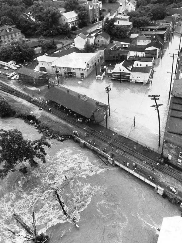
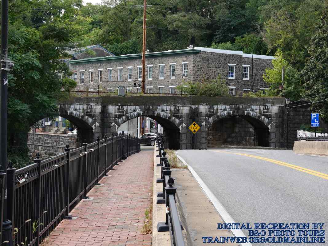
Cleanup work was underway after yet another flood poured through Ellicott City at the end of July 2016. This was the scene less than 72 hours after rains west of town funnelled down into the valley, eroding Main Street (distant left) and floating cars past the Oliver Viaduct into the Patapsco River.

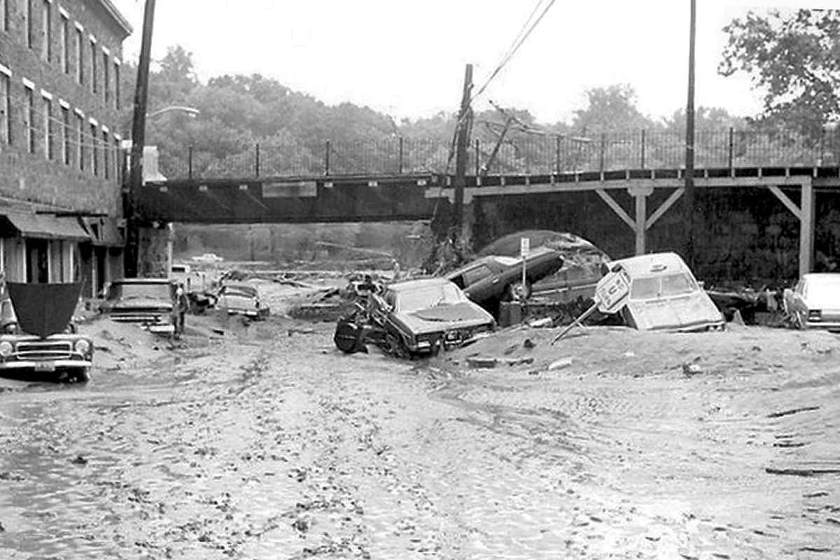
The flood killed several people and drew national attention. The town was closed to visitors and residents alike while repair work began, so this was as close as the public was allowed to get. Westbound CSX coal empties continued to roll, albeit extra slowly, meaning the railroad was undamaged. 
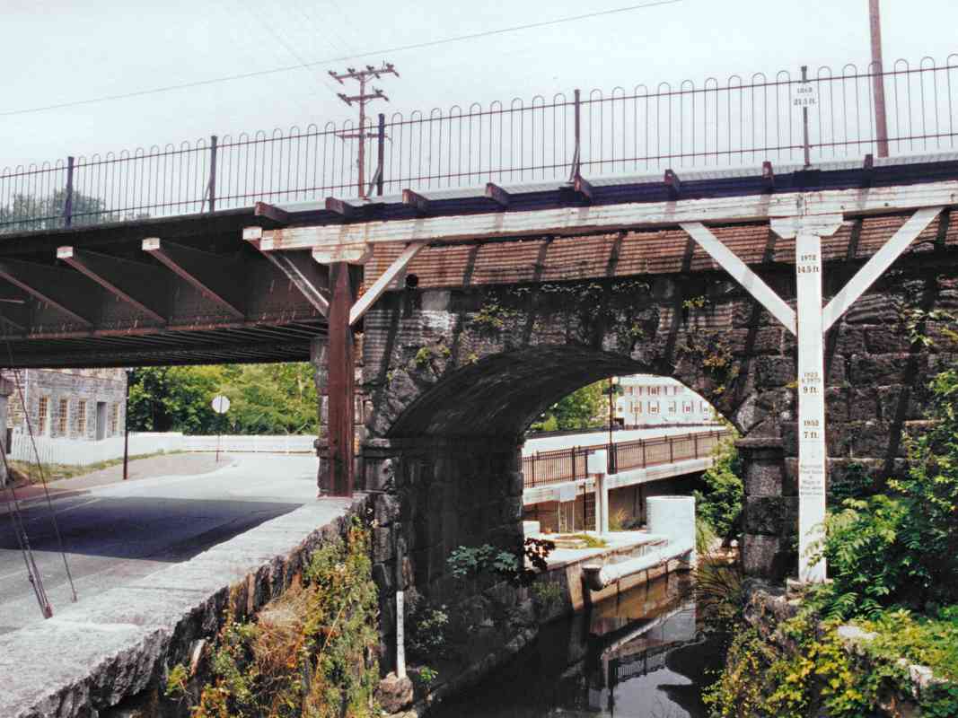
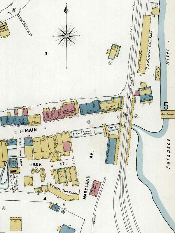
This time the Patapsco River was not the trouble, but rather the Tiber River and similar streams leading down into Ellicott City. Sadly, 
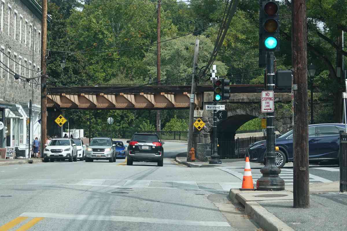
Main Street suffered a repeat flood during May 2018. EC map 1878

Reducing damage from future floods of this variety is not simple. After studying an 1878 map that traces the original routes of the Hudson and Tiber, and applying some engineering skill, I would think the least expensive option that can significantly reduce a repetition of the 2016 and 2018 events is construction of a wide culvert under St. Paul Street from behind Caplan's or thereabout east to the Patapsco River. Such a culvert would allow the water to flow downhill via a new path, one that does not employ Main Street (new storm sewers along Main Street could lead to the culvert). Additionally, such a route is shorter than other piping options, and runs mostly under existing public property (St. Paul Street).

Mitigating floods originating from a rising Patapsco River -- without relocating the town or rerouting Frederick Road -- would require impractically massive engineering.

Links: Baltimore Sun report, misc flood pics WBAL slideshow, NWS weather analysis


Ellicott City Station

Ellicott City Station
Mile: 12.8 Date: Dec 2000
Ease: A View: NE
Area: A IC2: 39
Map: Ho 12 G 9 Topographic Maps

The B&O Station in Ellicott City was used by the railroad until 1973, when it was refurbished into a small museum. In 1996, CSX donated the building to either the town or a preservation society, who recently completed additional restoration.

Link: 1970


Opposite View

Opposite View
Mile: 12.8 Date: Apr 2001
Ease: A View: SW
Area: A IC2:
Map: Ho 12 G 9 Topographic Maps

Here's a less often seen view of the station looking back from the Oliver Viaduct.

Links: 1972, 2008


Oliver Viaduct

Oliver Viaduct
Mile: 12.8 Date: Jul 1999
Ease: A View: E
Area: A IC2: 341
Map: Ho 12 G 9 Topographic Maps

Coterminous with the station is the sole survivor of three original arches that made up the Oliver Viaduct. This arch spans the tame looking Tiber Branch of the Patapsco River. But, appearances can be deceiving as the signs on the white support pole testify. Each sign designates the height of an historic flood to hit the valley.

The topmost sign on the pole shows the height of the water from Hurricane Agnes in 1972. But, look higher. On the fence is a sign that marks the peak water of the Flood of July 24, 1868. Newspaper reports from the time claim the water rose to that point (some 20 feet above normal) within the span of 30 minutes!

Amazingly, the other arches of the Oliver Viaduct were not removed by Mother Nature. Instead, the demands of the expanding town plus an accident on the Catonsville Trolley (which passed under the Viaduct) forced their removal around 1900 to improve traffic flow. Now Frederick Road (the country's first "National Road") passes under a replacement steel span, and the road bridge across the Patapsco can be seen through the arch.

Links: ~1970,


After Flood

After Flood
Mile: 12.8 Date: Jan 2017
Ease: A View: E
Area: A IC2: 341
Map: Ho 12 G 9 Topographic Maps

The 2016 flood destroyed the stone wall on the left that may have been original 1830 construction. That wall is seen in the 1955 photo below.

The flood height pole has not yet been replaced, nor has the railing at platform level. A new railing of B&O style has been installed at street level (foreground) along with a museum birdhouse.

Links: ~1900, 1955, Baltimore Sun photos


Derailment

Derailment
Mile: 12.8 Date: Aug 2012
Ease: A View: W
Area: A IC2:
Map: Ba 40 F 4, Ho 12 G 9 Topographic Maps

During August 2012, an eastbound coal train derailed near the station, killing two people at the viaduct. This view looks west from the Baltimore County side as damaged cars are lifted by crane and put onto trucks to be hauled away. Awaiting cleanup atop the viaduct we can see the inside of other hoppers still tipped on their side, spilling coal toward the camera.

Coal hoppers following behind (right) tumbled off the tracks and crushed automobiles in an adjacent public parking lot. One lesson: there is a certain level of risk near the tracks whether on or off railroad property.

Link to newspaper report and pictures: Baltimore Sun


Date Stone

Date Stone
Mile: 12.9 Date: Apr 2001
Ease: A View: NW
Area: A IC2:
Map: Ho 12 G 9 Topographic Maps

This curious date stone can be found at the northeast corner base of the Oliver Viaduct. It was laid on July 4, 1829.

Centered on the stone is A.D.1829, and chiseled above (i.e. probably as an afterthought) is A.L.5829. "A.L." stands for Anno Lucis, a calendar system employed by Freemasons. The origin is the old belief that the world was created 4,000 years before the birth of Christ. Many of the officials of the infant B&O were Freemasons.

"The Chronicles of Baltimore" written by Col. J. Thomas Scharf and published in 1874 described the opening of the railroad and bridge at Ellicott City as follows:

    On the 22d of May (1830), the president and directors of the Baltimore and Ohio R. R. Co. invited the members of the Legislature and other officers of the State, with the Mayor and City Council, the editorial corps, and some distinguished strangers and others, to proceed with them on their road to Ellicott's Mills. There were about 100 in all, in four carriages each drawn by one horse. In one of them Mr. Charles Carroll of Carrollton returned as far as Elk Ridge, where he took the stage and proceeded to Washington, being the first person who used this road as on a journey for business not connected with its immediate concerns. On the 24th of May the cars commenced their regular journeys for business, charging for the round trip 75 cents. On the 28th day of August, the main key-stone of the arches of the fine granite structure passing over the Frederick turnpike road at Ellicott's Mills, was adjusted in the presence of the directors of the company and many citizens assembled to witness the ceremony. Robert Oliver was called upon by the master-builder to assist in adjusting the stone; after which, the president of the company, Philip E. Thomas, addressed the spectators in a happy manner, during which he said:--"The directors of the Baltimore & O. R. R. Co., having deemed it advisable to dignify the several most important structures upon the road by the names of those citizens under whose influence and patronage this great work has been sustained, the first viaduct was honored with the name of the oldest and most revered of our citizens, the last survivor of that illustrious band who signed the instrument which declared us an independent nation. To the second was assigned the name of a liberal, patriotic, and highly esteemed fellow-citizen, William Patterson. The noble edifice of which we have just witnessed the completion, I have been instructed to designate by the name of a fellow-citizen no less distinguished for his liberality, public spirit, and generous support of the magnificent enterprise in which we have embarked. This structure will accordingly hereafter be distinguished by the name of the Oliver Viaduct."

Present Bridge

Present Bridge
Mile: 12.9 Date: Apr 2001
Ease: A View: W
Area: A IC2:
Map: Ho 12 G 9 Topographic Maps

By taking a few steps back from the date stone photo, we can see part of the bridge that now substitutes for two of the Oliver Viaduct's original stone arches. This incarnation of the bridge was built in 1931 by McClintic-Marshall, as the plaque attests.

On July 4, 2001 Howard County celebrated its 150th anniversary as indicated by the signpost in this view west up Main Street. Yes, when the railroad was built, Howard County was still part of Anne Arundel county.

At my back are the bridge remains of a trolley line which connected Ellicott City and Baltimore. The line is the subject of another page at this site.

Links: 1972, 2008


Ellicott City

Ellicott City
Mile: 13.0 Date: Mar 2000
Ease: C View: S
Area: B+ IC2: 39
Map: Ho 12 G 9 Topographic Maps

Sanborn map 1899 courtesy LoC Turning around and looking back as we depart Ellicott City yields this view. Compare to the circa 1900 similar photo in Impossible Challenge II page 39.

The Tarpean Rock, another early obstacle for the railroad, is not visible here, but sits immediately to the right of where this photo was taken.

An 1899 Sanborn map shows a siding existed on the left for trains to drop coal into bins of the S.J. Ratcliff company.

Links: 1970, 1984


Sucker Run

Sucker Run
Mile: 13.3 Date: Mar 2000
Ease: B View: SE
Area: A IC2:
Map: Ho 12 G 8 Topographic Maps

This fairly substantial stone arched bridge spans Sucker Run, located a short distance north of Ellicott City. Harwood's book indicates this is an original, circa 1830 bridge.


Sewer Line

Sewer Line
Mile: 13.3 Date: Mar 2000
Ease: B View: N
Area: A IC2:
Map: Ho 12 G 8 Topographic Maps

Several sewer lines like this are piped near Sucker Run. One was found broken subsequent to the flood at the end of July 2016.


Track Dresser
Photo courtesy Gene Leache

Track Dresser
Mile: 13.4 Date: Apr 2005
Ease: B View: SE
Area: A IC2:
Map: Ho 12 G 9 Topographic Maps

During the spring of 2005 CSX was busy with track replacement all along the OML. Here a track dresser pushes the ballast into place.


Fasteners
Photo courtesy Gene Leache

Fasteners
Mile: Date: May 2005
Ease: View:
Area: IC2:
Map: Topographic Map

The track work calls attention to the various generations and styles of rail fasteners in use. According to Gene Leache, their names are (from left to right) conventional spike, folded spike, single-ring lag screw, double-ring lag screw.


Oella
Updated mid-Apr 2018

Oella
Mile: 13.5 Date: Mar 2000
Ease: B View: NE
Area: A IC2:
Map: Ho 12 H 8 Topographic Maps

Brush obscures railroad bridgeworks dating to the early 1850s that served the Oella cotton mill across the river. Note both the granite blocks at left, and in the river the disused concrete support. When the Embargo Act of 1807 reduced the supply of imported goods, local businessmen formed the Union Manufacturing Company. Its first of several mills at the site opened during 1809 and endured until 1972.

bridge 1932 During the 1880s the original railroad bridge was replaced by the one seen at left that survived until the floods of 1972. Photo at left credit Office of Advisory Engineers on Water Supply, 1933 (unpublished), Water and Water Power Rights - Patapsco Project: Baltimore, Md., Baltimore City Department of Public Works, Public Improvement Commission, 375 pp. (digitized by the Maryland Geological Survey).

Reader Noel Tominak sent updated information:

    "I wanted to give you an update on Oella Mills, which is no longer an artist's enclave/antiques mall. It was sold to a developer in late 2004 and everything moved out over 2005. Its being completely gutted and will be rebuilt as 'The Residences at Oella Mill'."


40 Poles Per Mile
NEW! mid-Apr 2018

40 Poles Per Mile
Mile: 13.9 Date: Jan 2009
Ease: B View: N
Area: A IC2:
Map: Ho 12 H 7 Topographic Maps

B&O labeled every tenth utility pole with an asphalt tile, up to number 40. Along the OML utility poles were planted about 130 feet apart, making for 40 poles per mile. If a train stopped due to, for example, a bad car, the crew could count poles to identify and communicate the car's location. GPS and RFID tags have rendered that reckoning system outdated, and since photo time CSX has removed almost all these poles from the OML.


Millrace
NEW! mid-Apr 2018

Millrace
Mile: 14.1 Date: Jan 2009
Ease: B View: E
Area: A IC2:
Map: Ho 12 H 7 Topographic Maps

The railroad was not the only customer for cut stone. Across on the Baltimore County side of the river are found remains of the Union Manufacturing Company's millrace.


Culvert

Culvert
Mile: 14.5 Date: Nov 2001
Ease: C View: N
Area: A IC2:
Map: Ho 12 H 6 Topographic Maps

Beyond Ellicott City, the railroad re-enters Patapsco Valley State Park. Several small piped and box culverts like this one near River Ridge Trail can be found along this stretch.

Link: 1912


Wasps

Wasps
Mile: 14.7 Date: Nov 2001
Ease: C+ View: NW
Area: A IC2:
Map: Ho 12 H 5 Topographic Maps

Wasps have made a home on the back of this B&O style positional signal. CSX has since replaced such signals along the OML with more modern ones.


Greenery

Greenery
Mile: 14.9 Date: May 1999
Ease: C+ View: SW
Area: A IC2:
Map: Ho 12 J 5 Topographic Maps

Spring greenery makes this a scenic location. This spot is just south of the South (East) portal of Union Dam Tunnel. It can be reached via the Union Dam Trail down from the Hollofield Area of the park accessed via US Route 40. The trail is sloped and slippery, even when dry, and not recommended for casual walkers. Since the time of this photo CSX has removed these signals and utility poles.


Union Dam Tunnel

Union Dam Tunnel
Mile: 15.0 Date: May 1999
Ease: C+ View: NE
Area: A IC2:
Map: Ho 12 J 4 Topographic Maps

Built in 1902, Union Dam tunnel cuts off another sharp bend of the Patapsco River. Even so, the tunnel is constructed in a 7 degree curve, the most severe on the OML.


<< Previous (east) | THIS PAGE: Ellicott City to Union Dam | Next (west) >>

Or, return to main page

Copyright Notice