TrainWeb.org Facebook Page
URR Photo Tour


Union Railroad
Modern day photo tour

Accompanying each photo below are:

Click a photo to see a larger view. Please send your comments and corrections to Steve.


<< Previous (west) | THIS PAGE: Union Railroad South | Next (east) >>

Union Railroad (URR) - Brief Historical Background:

Map
Image courtesy Johns Hopkins University

Map
Mile: Date: 1948
Ease: View: N (up)
Area: T6:
Map: Ba 44 B 4 (center) Topographic Maps

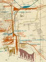
URR/NC trackage extended from the main line at Canton Junction near Orangeville, east of downtown Baltimore city, at map upper left. For tour purposes, we'll start there at the main line, a spot that in 2024 still serves as the branch's 0 milepost.

On this clip from a 1948 map made by Canton Railroad, this tour progresses generally south then southeast (down and to the right) along the orange/red line toward Sparrows Point, found off the bottom-right corner.


Canton Junction
Photo courtesy Frank Wrabel
NEW! Dec 2024

Canton Junction
Mile: -0.1 Date: 1935
Ease: B View: SE
Area: B- T6: 293
Map: Ba 35 K 11 Topographic Maps

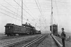
Canton Junction Tower stands by as electricity is added along the main line. The branch to Canton diverged to the right behind the tower and was never electrified. This is the second Canton Junction. The original Canton Junction, the one along URR"s original alignment, was located about 600 feet to the north-northeast (left).


AMTK 2014

AMTK 2014
Mile: -0.3 Date: Aug 2016
Ease: B View: SE
Area: B- T6: 292
Map: Ba 35 J 11 Topographic Maps

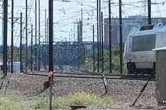
Amtrak engine 2014 is about to reach the second Canton Junction. Milepost 93 points across the tracks to the site of the tower in the prior photo. The disused Canton Branch's starting location is remembered by wider-than-usual separation between catenary poles near photo center, right of the tracks.


Aerial 1927
Photo courtesy Johns Hopkins University

Aerial 1927
Mile: Date: 1927
Ease: View: N (up)
Area: T6: 293
Map: Ba 35 K 12 Topographic Maps

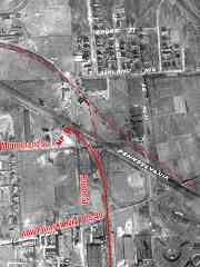
There were two Canton Junctions here because of two alignments. The oldest (now mostly disused) is represented by dashed lines. Those lines trace the original, at-grade route of URR on its way east to meet the Philadelphia, Wilmington and Baltimore Railroad (PW&B) division of PRR, and the at-grade spur to Canton.

This 1927 aerial zooms into milepost ("MP 0") at the second Canton Junction. The dark square adjacent the 0 digit was the tower. The red crosshatched line down to photo bottom traces this tour's path.


Haven Street

Haven Street
Mile: 0.1 Date: Aug 2016
Ease: A View: N
Area: B- T6:
Map: Ba 35 K 11 Topographic Maps

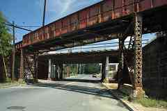
Train traffic increased along the main line after the Civil War, which made grade crossings more dangerous, so PRR funded grade separations in 1893. Two of them are visible from Haven Street. The nearer of the two, carrying the line to Canton, employs support columns with diagonal segments also found on other bridges of the 1890s. The durable stone abutments are typical of that period; by 1910, concrete was typically employed instead.

The distant bridge, which carries Amtrak's Northeast Corridor, was refurbished during the 20th century.


Not Double Tracked

Not Double Tracked
Mile: 0.1 Date: Aug 2018
Ease: A View: E
Area: C+ T6:
Map: Ba 35 K 11 Topographic Maps

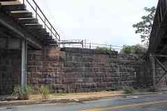
Uniform masonry tells us the Haven Street bridges for the main line (left) and the Canton branch (right) were built concurrently in 1893. The empty stone shelf on the right says provisions were made to support a second branch track, something that never transpired at this location.


Monument Street

Monument Street
Mile: 0.2 Date: May 2023
Ease: A View: W
Area: B- T6:
Map: Ba 35 K 11 Topographic Maps

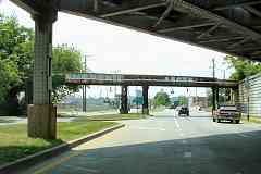
The branch's longest bridge (distant) that does not span water is found at Monument Street. Its south half (left) is older because it dates to before Monument Street was twinned in 1956. Streetcar line 6 had run along the median while NC's Orangeville Station stood in the southeast quadrant. Amtrak uses the bridge over the photog's head.

Link: 1947


Pulaski Highway

Pulaski Highway
Mile: 0.3 Date: Aug 2016
Ease: A View: E
Area: B- T6:
Map: Ba 35 K 12 Topographic Maps

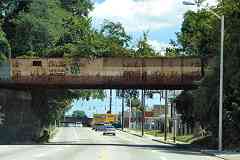
Stone supports suggest grade separation happened at Pulaski / US 40 when it did at Haven Street (1893).

Aerial photos from 1972 show trains still using this route, but these vines and trees tell a different story is true now. Floods from Agnes during June 1972 destroyed many ex-NC bridges north of Baltimore. The railroad decided to not repair them, which meant traffic from the north to the waterfront ceased, which reduced this line to serving only its already-dwindling number of local customers. The last train rolled here soon thereafter.

NC's alignment descends into a cut while it parallels Haven Street south (right) for about a mile.

Detour: floods in Patapsco Valley State Park


Aerial 2023
Photo courtesy Google
NEW! Dec 2024

Aerial 2023
Mile: 0.6 (center) Date: Sep 2023
Ease: View: N (up)
Area: T6:
Map: Ba 35 K 12 Topographic Maps

Dark green trees had overgrown the disused line by 2023, and homeless have taken up residence. Pulaski Highway curves left to right at the top. Below photo center, a gray strip of parking lots has covered the railroad's former right of way.

The bright, triangular building slightly left and below photo center has a curved hypotenuse -- evidence of the former NC spur to Esskay in the next panel.


NC Spur
NEW! Dec 2024

NC Spur
Mile: 0.5 Date: May 2023
Ease: A View: S
Area: C T6:
Map: Ba 35 K 13 Topographic Maps

NC's spur to Esskay crossed Haven Street where you see the diagonal stripe of blacktop patching in the foreground. B&O's spur crossed at the high spot where traffic congregates in the distance.


B&O Spur

B&O Spur
Mile: 0.6 Date: Aug 2016
Ease: B View: W
Area: C T6:
Map: Ba 35 K 13 Topographic Maps

B&O used this bridge to Esskay and Monumental Brewery in order to cross over the URR/NC branch to Canton. I can't think of another disused rail bridge over a disused rail line in this region. In their northeast quadrant had stood the Conowingo Wall Paper Company.

The tour is now reaching Canton, on the east side of Baltimore, that was perhaps the first planned city in the United States. It is where Peter Cooper, of steam engine fame, during the 1820s bought about 3 miles of waterfront property. He and other entrepreneurs soon joined forces as the "Canton Company" to develop the land with wharves, factories, housing and more. They were successful after a slow start.


Aerial 1972
Photo courtesy Johns Hopkins University

Aerial 1972
Mile: 0.9 (center) Date: Mar 1972
Ease: View: N (up)
Area: T6:
Map: Ba 35 K 13 Topographic Maps

We've moved a bit south such that B&O's spur to Esskay curves at the top. It was active until 1993. Esskay is easier to pronounce than the original company name of Schluderberg-Kurdle. Esskay, a standard at Orioles baseball games for decades, ended hot dog production during 2018.

The small bright rectangle immediately below that is the Lombard Street bridge over the line we're following. Railcars pause on the line south of Eastern Avenue at photo bottom. The route angling in at bottom right comes from Bay View Yard; it remains active as of 2024.


Lombard Street

Lombard Street
Mile: 0.7 Date: May 2023
Ease: A View: NW
Area: C T6:
Map: Ba 35 K 13 Topographic Maps

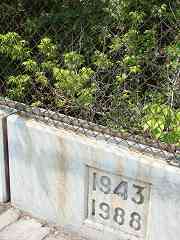
Lombard Street rises about 20 feet over the most densely treed stretch of the line. Some rusty rails are probably still down there. Aerial photos show grade separation already existed during the 1920s, so 1943 represents the first, or even second, time Lombard Street's bridge was rehabbed.


1927 Eastern Avenue
Photo courtesy Johns Hopkins University
NEW! Dec 2024

1927 Eastern Avenue
Mile: 0.2 Date: 1927
Ease: View: N (up)
Area: B- RBL:
Map: Ba 43 K 1 Topographic Maps

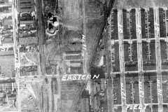
That marked 8th (Street) at left is now Haven Street. The rail line we are following parallels it on the right as if 9th Street, and meets Eastern Avenue at grade. The / diagonal began as PW&B's main line to Baltimore's President Street Station, but by photo time also connected to the line this tour follows. The dark rectangle left of the E of EASTERN is the shadow of Highlandtown Station, seen in the photo below.


Highlandtown Station
Photo courtesy Baltimore Streetcar Museum
and Digital Maryland
NEW! Dec 2024

Highlandtown Station
Mile: 1.0 Date: 1910s
Ease: A View: E
Area: C+ T6:
Map: Ba 35 K 13 Topographic Maps

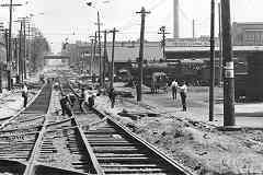
That appears to be a PRR H Class 2-8-0 Consolidation locomotive at Highlandtown Freight Station. An 1898 atlas labels it Eastern Avenue Station. Note that PRR applied its name, rather than NC's, to the station's sign. At photo time, NC was gradually being assimilated into the PRR collective.

In the foreground, United Railways and Electric (UR&E) workers are busy enhancing trolley coverage along Eastern Avenue. The Ford Model T automobile was not yet widespread.

Link: photo source


Trolley Interior
Photo courtesy Baltimore Streetcar Museum
and Digital Maryland
NEW! Dec 2024

Trolley Interior
Mile: Date: 1910s
Ease: View: S?
Area: T6:
Map: Ba 42 H 2? Topographic Maps

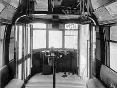
This example typifies the interior appearance of UR&E trolley cars. The sign at upper left reads, "Safety First Alphabet - V is for victim of unseemly haste. Have a care, watch your step. And no time will you waste." Meanwhile, lettering over the exit door reads "Move Quickly Please".

Link: photo source


Eastern Avenue 1910s
Photo courtesy Baltimore Streetcar Museum
and Digital Maryland
NEW! Dec 2024

Eastern Avenue 1910s
Mile: 1.0 Date: 1910s
Ease: A View: E
Area: C+ T6:
Map: Ba 35 K 13 Topographic Maps

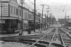
Haven Street meets Eastern Avenue where one could find O. Gentile's shop on the corner. This row of shops and homes was razed in 1930 in order to grade separate Eastern Avenue from both NC and PW&B lines. A foresightful B&O had already grade separated its line via the distant bridge.

Link: photo source


Eastern Avenue

Eastern Avenue
Mile: 1.0 Date: May 2023
Ease: A View: E
Area: C+ T6:
Map: Ba 35 K 13 Topographic Maps

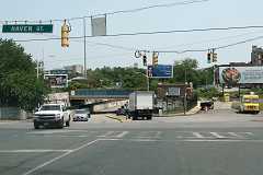
A century plus later, the same location looked like this. Original Eastern Avenue met NC at grade near the billboard on the right. The avenue, and its streetcar, were grade separated from multiple railroad alignments via the cut on the left made during 1930. The blue-painted bridge carried NC, three tracks wide at this point. Some of those rails are still on the bridge.

Link: streetcar line 26


Janney at Eastern 1915
Photo courtesy Baltimore Streetcar Museum
and Digital Maryland
NEW! Dec 2024

Janney at Eastern 1915
Mile: 1.0 Date: 1915
Ease: A View: E
Area: C+ T6:
Map: Ba 35 K 13 Topographic Maps

East of Highlandtown Station, PRR's other line to Canton, that of PW&B from Bay View, also crossed Eastern Avenue and the UR&E trolley. This view is closer to the same B&O bridge over Eastern Avenue seen in the similar vintage scenes above.

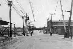
The covers over UR&E's power lines were not so much covers as a way to reduce the chance a trolley's conducting arm would lose contact with the power line as it bumped over PW&B's tracks. A railroad crossing is not a safe place to lose power and get stuck. Triangular semaphore signals, such as the one affixed to the rightmost pole, regulated trolley movement.

The Vogel frost proof closet (billboard at left) was a brand of toilet that resisted freezing. If you don't know why water in toilets might freeze, consider yourself lucky to live with indoor plumbing and reliable heating.

Link: photo source


Rails and Grass

Rails and Grass
Mile: 1.0 Date: May 2023
Ease: A View: N
Area: C T6:
Map: Ba 35 K 13 Topographic Maps

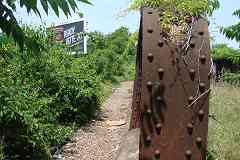
No train has passed Eastern Avenue via this bridge for about half a century, but rusty rails still peek out where not overtaken by plants. Highlandtown Station stood off photo right.


From O'Donnell Street

From O'Donnell Street
Mile: 1.4 Date: Jul 2016
Ease: A View: N
Area: C T6:
Map: Ba 43 K 2 Topographic Maps

The branch continued south from Eastern Avenue toward O'Donnell Street. It's overgrown now, as suggested by the stand of trees at center. Row houses were built there circa 2020.

Here, the NC (center) and met PW&B (right) lines had crossed. Not long after Agnes obviated NC's Canton branch, street running ceased on PW&B's former track west (left) from here. So, new-owner Conrail redirected traffic from the former PW&B line via the curve seen here so it would join the Canton Branch we are following. The tracks appoaching the camera have become Norfolk Southern's primary route from its Bay View Yard to the waterfront.


Boston Street

Boston Street
Mile: 1.7 Date: Nov 2016
Ease: A- View: N
Area: C- T6:
Map: Ba 43 K 2 Topographic Maps

We're looking north again since it makes for better lighting, even if it's opposite the tour direction. O'Donnell Street (prior panel) bridges in the distance but Boston Street (foreground) has never been grade separated. Behind the photog, NC's branch spreads into spurs, sidings and yards to serve various docks at the Canton waterfront.

The auto westbound on Boston Street has just crossed over the ex-NC track that leads toward Sparrows Point. A 1948 map puts Sparrows Point Junction here.

Change for: Canton Railroad tour at this site


NS 9686

NS 9686
Mile: 1.7 Date: Nov 2016
Ease: A- View: S
Area: C- T6:
Map: Ba 43 K 2 Topographic Maps

Though looking the other way from Boston Street yields sun glare, we can find NS 9686's horse kicking grass and CSX 3222's cat taking names in their shared yard. NS's main activity in this area is delivery to CONSOL Energy, at far right in this view. The distant big green signs are above I-95.

Change for: B&O Sparrows Point Branch tour at this site


From I-95

From I-95
Mile: 2.1 Date: Mar 2023
Ease: A View: NW
Area: B T6:
Map: Ba 44 A 3 Topographic Maps

One can look back from I-95 to the location of the prior photo. I-895 traverses under I-95 here. We're following the line on which the yellow-orange boxcar is parked toward and off photo right.

Change for: Canton RR tour at this site


From I-895

From I-895
Mile: 2.2 Date: Aug 2017
Ease: A View: S
Area: B T6:
Map: Ba 44 A 4 Topographic Maps

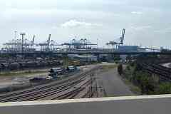
Looking from I-895 in the direction of this tour, on the left CSX and Canton Railroad share Penn Mary Yard, occpied by tank cars on this day, while on the right, NS's coal hoppers await unloading at CONSOL Energy. In the middle, previously the site of Gorsuch Creek and pond, the ex-NC yard contains nothing much on this day.

Huge cranes in the distance unload and load huge ships at Seagirt Marine Terminal. The ex-NC route we're following bypasses Seagirt in favor of the Dundalk Marine Terminal, adjacent but off photo left. The terminals are descendants of those started by Canton Company before the Civil War.

Newkirk Street parallels the tanks on the left. That's shown in the next panel.


From Newkirk Street

From Newkirk Street
Mile: 2.3 Date: Jul 2016
Ease: A View: S
Area: C T6:
Map: Ba 44 A 4 Topographic Maps

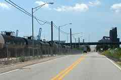
The tanks look bigger from Newkirk Street.

The ex-NC track to Sparrows Point emerges from the yard to cross Newkirk Street just beyond the trailer parked on the left.

Beyond that runs elevated Keith Avenue.


PRR Grain Terminal
Photo courtesy Johns Hopkins University

PRR Grain Terminal
Mile: Date: 1924
Ease: View: E
Area: T6: 299
Map: Ba 43 K 5 Topographic Maps

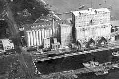
A short spur ran to PRR's gigantic waterfront grain terminal at the south end of Newkirk Street, formerly 14th Street. Grain from Pennsylvania farms was hauled here via the NC route later damaged in 1972's storm.

Links: ~1920s waterfront photo, ~1930?


Demolition

Demolition
Mile: Date: Jul 2016
Ease: A View: S
Area: C T6:
Map: Ba 44 A 5 Topographic Maps

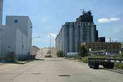
Removal of the disused grain terminal began during 2016.


From Keith Avenue

From Keith Avenue
Mile: 2.5 Date: Jul 2016
Ease: A View: N
Area: B T6:
Map: Ba 44 A 4 Topographic Maps

That's the ex-NC grade crossing of Newkirk Street near photo center, as seen from Keith Avenue.

When Maryland Steel Company of Baltimore County opened during the 1890s a few miles east of here at Sparrows Point, a new railroad customer was born. The steel company built track within its grounds, creating the Baltimore & Sparrows Point Railroad (B&SP), plus a leg west into Canton. It was in this vicinity that in 1916 NC and B&SP joined rails. NC would later purchase part of the B&SP route seen on the next tour page.


Aerial 1938
Photo courtesy Johns Hopkins University

Aerial 1938
Mile: Date: Apr 1938
Ease: View: N (up)
Area: T6: 301
Map: Ba 43 K 5 (center) Topographic Maps

The spur south to Canton spread into waterfront sidings that ended at the Canton RR Terminal.

The spur tour ends here, but you can continue southeast to Sparrows Point via the "Next" link below.


<< Previous (west) | THIS PAGE: Union Railroad South | Next (east) >>

Or, return to main page

Copyright Notice