TrainWeb.org Facebook Page
PRR / Amtrak Photo Tour


PRR / Amtrak in Maryland
Modern day photo tour

Accompanying each photo below are:

Click a photo to see a larger view. Please send your comments and corrections to Steve.


Special Note: >>> The places described on this page host quiet, high-speed trains. Stay well clear! <<<

<< Previous (north) | THIS PAGE: Union Station, Washington, DC | End of tour || main index

Metro Addition
Photo courtesy Library of Congress

Metro Addition
Mile: 135.3 Date: 1977
Ease: View: S
Area: B T6:
Map: DC 16 D 1 Topographic Maps

Union Station surrendered six tracks to make room for Metro's two, which in this zoom are the rightmost tracks that pass under H Street. The year prior to this photo, specifically on March 27, 1976, Metro service to Union Station was part of the first section of the system opened to public use.

In the shadows beyond, Metro's two tracks dip sharply in order to pass under the elevated spur on the right to the GPO building.

Links: LoC source photo, 1986


GPO Spur
Photo courtesy Dave Hiteshew

GPO Spur
Mile: 135.8 Date: Sep 2008
Ease: B View: N
Area: B T6:
Map: DC 16 D 1 Topographic Maps

This disused elevated spur at First and G Streets had connected Union Station (right) with the Government Printing Office (left), now Government Publishing Office. Paper by the trainload could be delivered directly into the GPO without any street running. The GPO has been housed at this location since 1903, which suggests this spur dates to the arrival of Union Station shortly after.


DC Metro

DC Metro
Mile: 135.8 Date: Jul 2019
Ease: B View: ?
Area: B T6:
Map: DC 16 D 1 Topographic Maps

Union Station is the busiest stop in DC's Metro system.


Bus Terminal

Bus Terminal
Mile: 135.8 Date: Jul 2019
Ease: B View: W?
Area: B T6:
Map: DC 16 D 1 Topographic Maps

Various bus stations combined efforts to form the Union Station Bus Terminal.


Concourse 1910
Photos courtesy Library of Congress

Concourse 1910
Mile: 135.9 Date: ~1910
Ease: B View: W
Area: B T6:
Map: DC 16 D 1 Topographic Maps

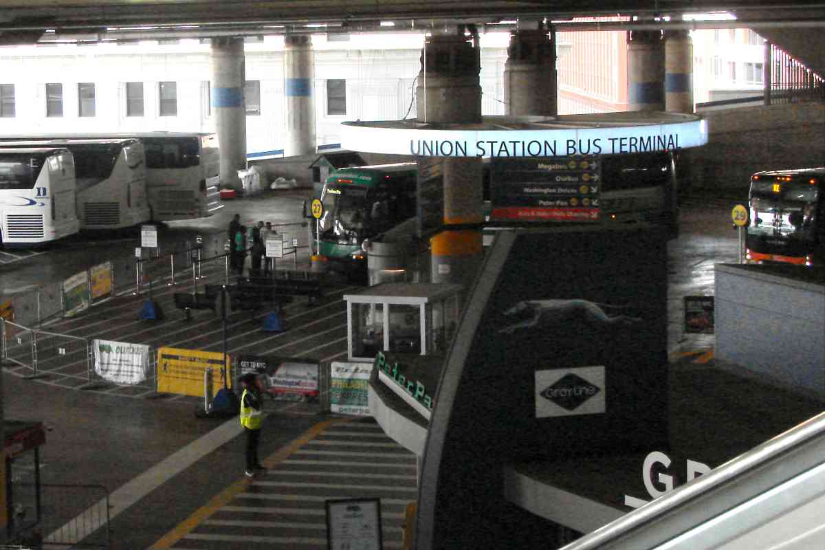
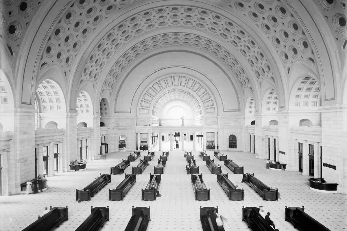
The vast rear concourse was found at the gates. Why is there not more seating for waiting passengers? Perhaps outgoing passengers were not permitted here until their train was ready, at which time they proceeded directly through to board.

gates 
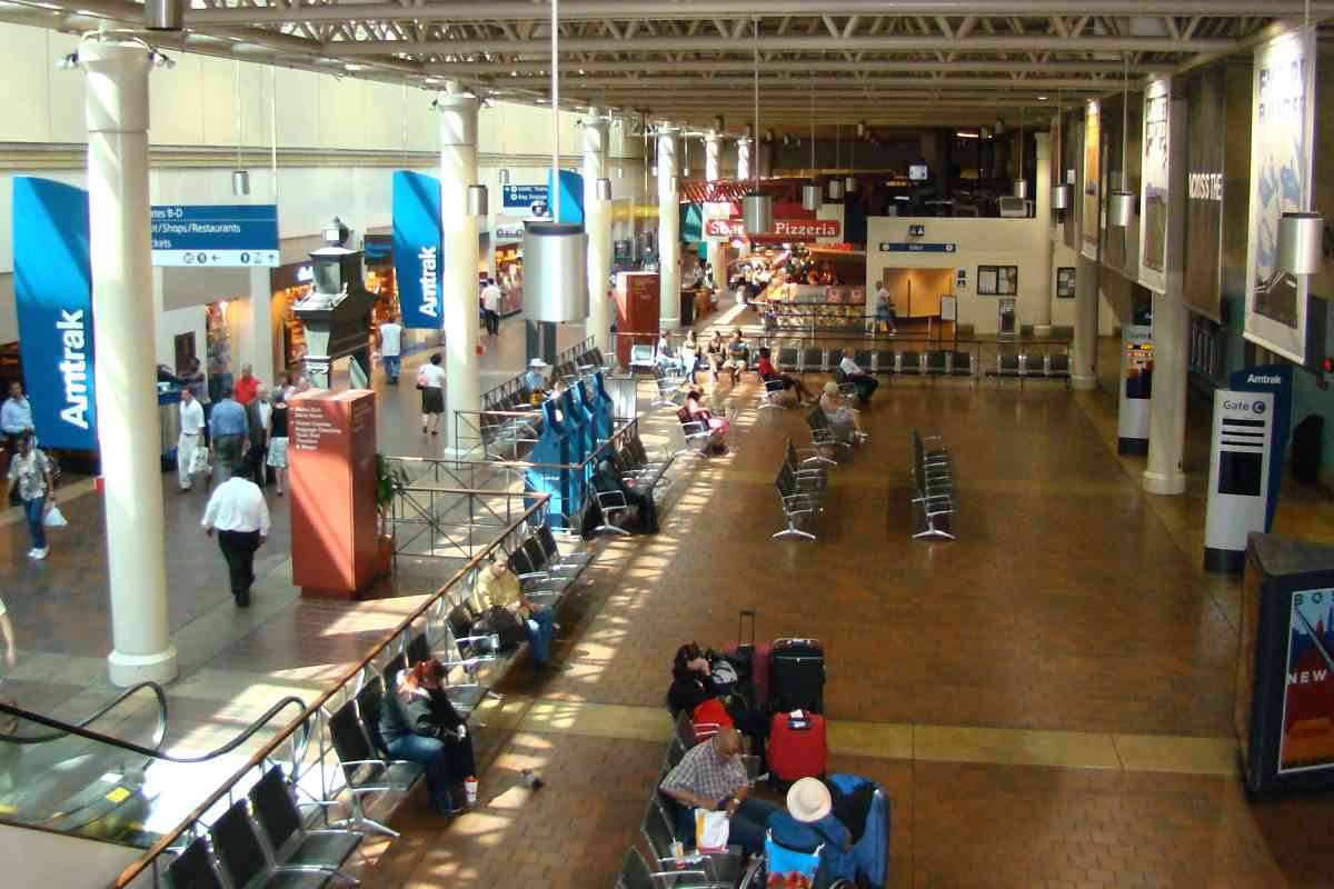
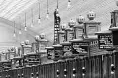
Represented via gate signage are the Pennsylvania RR, Chesapeake and Ohio, Washington Southern, and the Southern. B&O is not represented, but did serve the station. Now, LED lamp endurance means fewer trips up and down tall ladders to replace burned out bulbs, as at right.

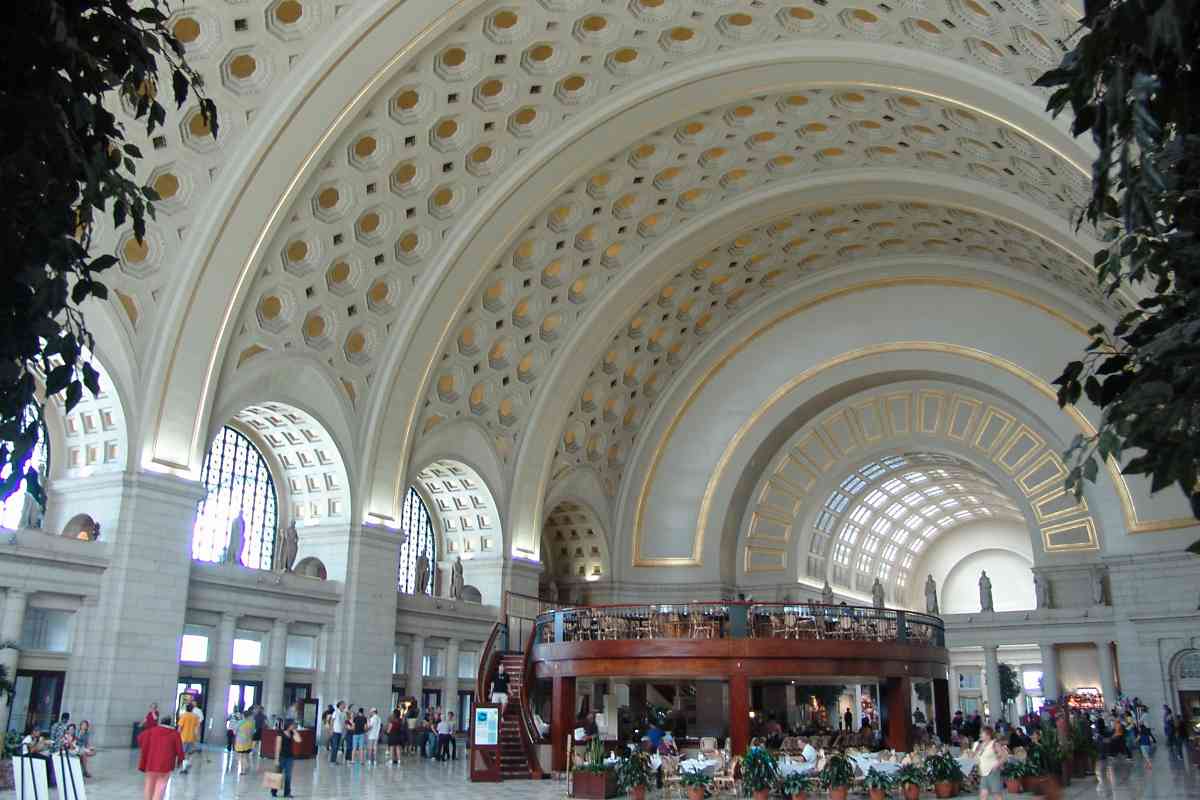
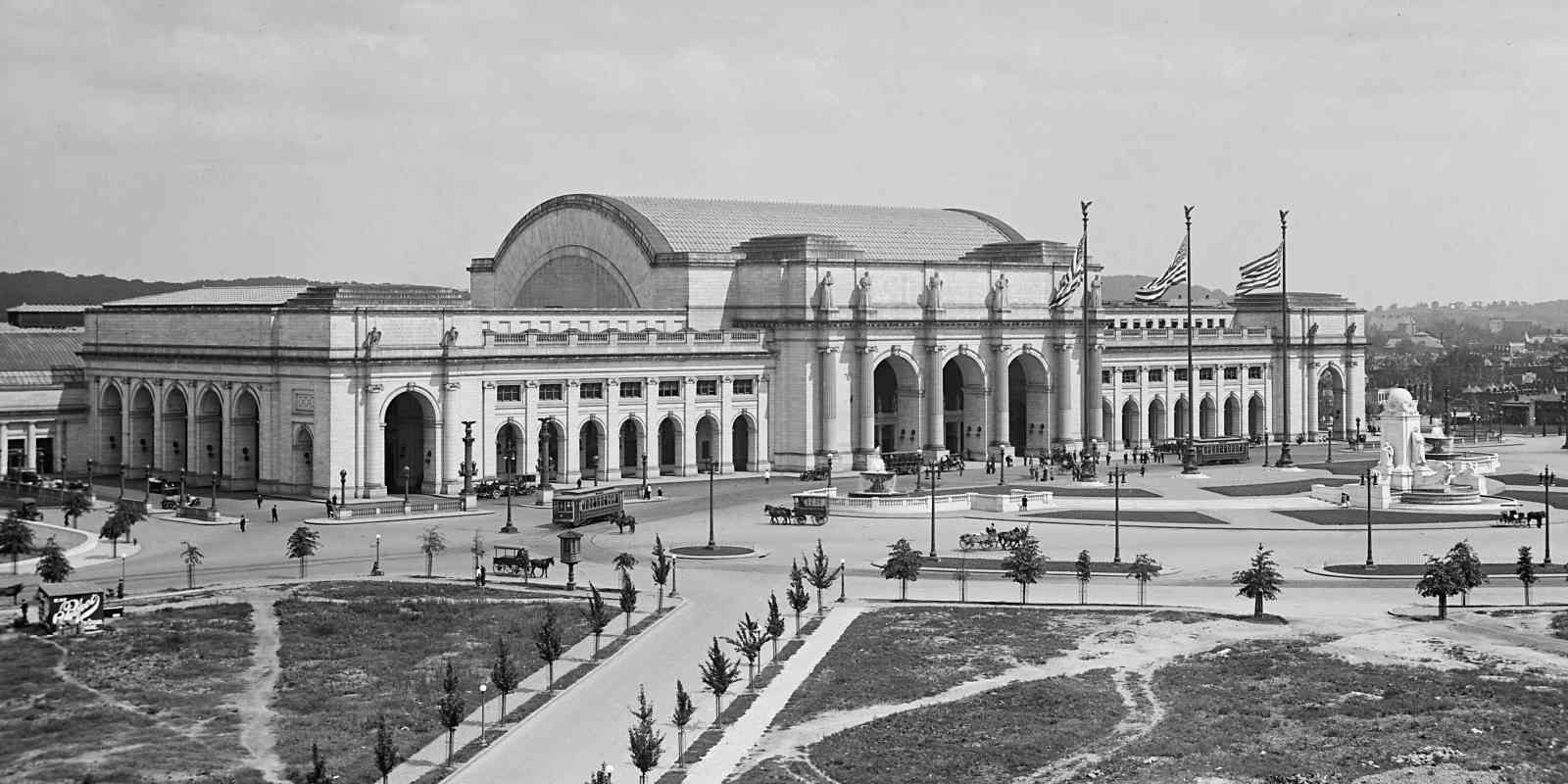
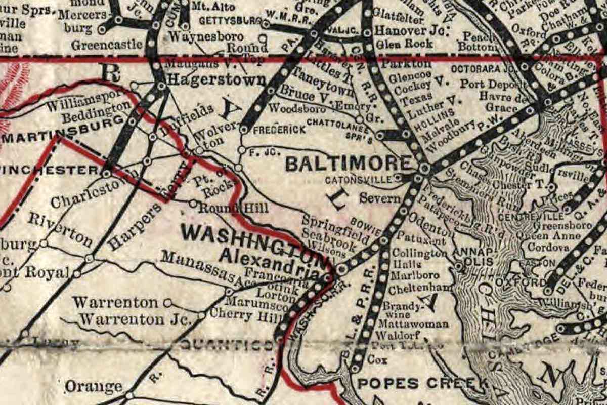
Washington Southern was formed by a merger of Alexandria and Fredericksburg Railway with Potomac Railroad, and during 1920 it merged into the Richmond, Fredericksburg and Potomac Railroad.

Links: reverse view 1910, 1921, buy a new car 1938, 1942, 100,000 one day 1944


Concourse 2008
Photo courtesy Dave Hiteshew

Concourse 2008
Mile: 135.9 Date: Sep 2008
Ease: B View: W
Area: B T6:
Map: DC 16 D 1 Topographic Maps

The rear concourse has been modified so much as to be unrecognizable to someone from 1910. The gates to the platforms are still on the right though.


Shopping

Shopping
Mile: 135.9 Date: Jul 2019
Ease: B View: ?
Area: B T6:
Map: DC 16 D 1 Topographic Maps

The front concourse's 1980s makeover installed many shops. Tickets counters are at distant center.


Tickets 1958
Photo courtesy Library of Congress

Tickets 1958
Mile: 135.9 Date: 1958
Ease: B View:
Area: B T6:
Map: DC 16 D 1 Topographic Maps

During the 1950s computers began to handle ticketing, but lots was still done by hand on paper.

Link: 1942 ticketing in lobby


Tickets_2019

Tickets 2019
Mile: 135.9 Date: Jul 2019
Ease: B View:
Area: B T6:
Map: DC 16 D 1 Topographic Maps

This is a similar view from about 60 years later.


Food Court

Food Court
Mile: 135.9 Date: Jul 2019
Ease: B View: NE?
Area: B T6:
Map: DC 16 D 1 Topographic Maps

What had been Union Station's baggage and parcel area was during the 1980s reformed into this food court. Union Station has become a sort of shopping mall with trains, lots of trains.


Lobby 1910
Photos courtesy Library of Congress

Lobby 1910
Mile: 135.9 Date: ~1910
Ease: B View: NW
Area: B T6:
Map: DC 16 D 1 Topographic Maps

signs During 1910 the front lobby was the main waiting area. The signs at distant left read: Telephones, Barber Shop, Smoking Room, Stop Over Ticket Office, Ticket Office, To Carriages, Baggage Room, Information, Parcel Room, Postal Telegraph, Western Union Tel. Not shown is a separate waiting room just for ladies.

Presumably the Stop Over Ticket Office was separate from the main ticket office because passengers who decided to stay in Washington overnight consumed more of the clerks' time with questions about sights to see, how to get there, etc.


Lobby 2008
Photo courtesy Dave Hiteshew

Lobby 2008
Mile: 135.9 Date: Sep 2008
Ease: B View: W
Area: B T6:
Map: DC 16 D 1 Topographic Maps

This is a similar view about a century later. The main entrance in is on the left side, with ticketing and trains to the right. Perhaps the honeycomb ceiling design found here served as the inspiration for that in DC Metro subway stations.

Link: ~1921


Union Station 1906
Photo courtesy Library of Congress

Union Station 1906
Mile: 136.1 Date: 1906
Ease: A View: NE
Area: B T6:
Map: DC 16 D 1 Topographic Maps

As Union Station neared completion, both horse carts and streetcars were bringing supplies and workers to the site.

Daniel Burnham's architecture here is a fine example of the Beaux Arts style that peaked in the United States around the time the station opened, but which has a timeless quality about it. The railroad industry peaked around that time too, but remains timeless as well.

Links: LoC source photo, streetcar track diamonds


Union Station 1913
Photos courtesy Library of Congress

Union Station 1913
Mile: 136.1 Date: 1913
Ease: A View: NE
Area: B T6:
Map: DC 16 D 1 Topographic Maps

wealth of the indies Rather grandiose inscriptions were chiseled into the exterior stone, for example, "He who would bring home the wealth of the Indies must carry the wealth of the Indies with him. So it is in travelling: a man must carry knowledge with him, if he would bring home knowledge." -Samuel Johnson

Links: Union Station gallery, ~1908, 1942


Statues

Statues
Mile: 136.0 Date: Jul 2019
Ease: A View: E
Area: B T6:
Map: DC 16 D 1 Topographic Maps

electricity Installed over a span of years, six tall Vermont marble statues by sculptor Louis Saint-Gaudens grace the entrance. The statues represent Apollo, Archimedes, Ceres, Prometheus, Thales,and Themis. The choice of Thales, leftmost in the zoom view, was particularly prescient in that he is the Greek god of electricity, and electrically-powered trains would not begin arriving at Union Station for roughly another 20 years.

Link: Thales statue being installed 1912


Aerial 1921
Photo courtesy Library of Congress

Aerial 1921
Mile: 136.1 Date: 1921
Ease: View: N
Area: B T6:
Map: DC 16 D 1 Topographic Maps

The non-random arrangement of people around Union Station suggests a special event was underway at the time of this photo, but information with the photo did not specify.

Links: Union Station closed 1981, 1980s restoration photos, 1988 reopening


Union Station 1999

Union Station 1999
Mile: 136.0 Date: Jun 1999
Ease: A View: NE
Area: B T6:
Map: DC 16 D 1 Topographic Maps

Union Station's semicircular plaza echoes its early days as a loop for streetcars. Streetcars gave way to automobiles curving along Columbus Circle. A statue of Christopher Columbus stands tall within within the circle, while flags of each of the 50 states line the outside edge.

The B&O Metropolitan Branch tour has photos of the Columbus statue as well as more of the station's exterior. A link to that tour is near page bottom.

Links: 1942, Washington Terminal Project PRR photos


B&P Station
Photo courtesy National Archives

B&P Station
Mile: on spur Date: 1881?
Ease: View: SE?
Area: T6:
Map: DC 16 B 2 Topographic Maps

Prior to Union Station, B&P's first Washington station, a small wooden structure, was in 1873 replaced by this masonry structure at 6th and B Streets (now Constitution Avenue) NW, presently the location of the West Building of the National Gallery of Art. President James Garfield was assassinated at this station during 1881. The building was demolished soon after Union Station opened.

B&P reached the station via what has become CSX's Landover Subdivision, previously the PRR's Landover to South End freight line. Today the route is approximately traced by the Anacostia Freeway (DC 295) and the Southeast Freeway (I-695).

Link: ~1900


1893 Map
Map courtesy Library of Congress

1893 Map
Mile: Date: 1893
Ease: View:
Area: T6:
Map: Topographic Maps

This Pennsylvania Railroad system map from 1893 displays its view of the railroading world. B&O is represented with thin lines, and few stops, such as "Wolverton" which should be Weverton. The B&O lines that connect Washington, Baltimore, and Philadelphia are not even depicted. Such was the perspective of the standard railroad of the world, an impressive operation by any measure.

Links: LoC Penn Line photos, Amtrak's Northeast corridor photos


The Northeast Corridor tour ends here. Thanks for following along!

Consider proceeding northwest along B&O's Metropolitan Branch,
or follow PRR's route from Potomac Yard into Washington.

<< Previous (north) | THIS PAGE: Union Station, Washington, DC | End of tour || main index

For other tours here now, select from the map: clickable map

Or, return to main page

Copyright Notice