TrainWeb.org Facebook Page
PRR / Amtrak Photo Tour


PRR / Amtrak in Maryland
Modern day photo tour

Accompanying each photo below are:

Click a photo to see a larger view. Please send your comments and corrections to Steve.


Special Note: >>> The places described on this page host quiet, high-speed trains. Stay well clear! <<<

<< Previous (north) | THIS PAGE: Union Station Yard | Next (south) >>

Construction 1977
Photo courtesy Library of Congress

Construction 1977
Mile: 135.3 Date: 1977
Ease: View: S
Area: B T6:
Map: DC 10 Topographic Maps

While the H Street bridge over the tracks neared completion, one of the first clear signs of railroad activity picking up from the early 1970s doldrums was the addition of an automobile parking deck behind Union Station. A second, larger deck would follow a couple decades later.

Near photo bottom, that's K Street sneaking under the tracks.

Links: LoC source photo, from ground 1977


K Street
Photo courtesy Dave Hiteshew

K Street
Mile: 135.5 Date: Sep 2008
Ease: A View: E
Area: B T6:
Map: DC 10 D 13 Topographic Maps

signal blinker Almost underneath K Tower is a combination of stone, steel, and modern concrete that permits K Street traffic to pass.

On the right is a non-standard application of a traffic signal as a warning blinker. The red and green went unused. Since photo time this signal has been removed.


H Street 1960
Photo courtesy District Department of Transportation (DDOT) Library

H Street 1960
Mile: 135.7 Date: Feb 1960
Ease: A View: E
Area: B T6:
Map: DC 16 D 1 Topographic Maps

The H Street bridge/tunnel, whichever perspective you prefer, shows its original form in this circa 1960 photo. The leftmost two automobiles are easy to identify (1957 Chevrolet, 1959 Chevrolet), the details and others I'll leave as a challenge for readers.

Those are oddly placed windows and coverings on the PRR coach above. I asked around but no one knew what that's about. A converted car?

Link: DDOT source photo


H Street 1972
Photo courtesy District Department of Transportation (DDOT) Library

H Street 1972
Mile: 135.7 Date: Nov 1972
Ease: (no access) View: E
Area: B T6:
Map: DC 16 E 1 Topographic Maps

Before the H Street bridge spanned Union Station's yard, auto traffic used this underpass. At photo time, "Amtrak" had not yet been painted onto all rolling stock, hence the "Penn Central"-labelled coach waiting above. (That lettering is difficult to see through lamp glare.)

Just two years after this H Street underpass was relighted with the mercury-vapor lamps seen here, it would be closed to make way for the H Street bridge. Those bluish mercury-vapor lamps on many city streets would in a decade or two be swapped out for brighter, orangish sodium-vapor ones.

Many sodium-vapor street lamps gave way to LEDs during the 2010s. Though LEDs existed at the time of this photo, decades of research were needed to make them bright enough for street lighting. You'll have to wait until, oh, perhaps the 2030s to find out what lamp comes next.

Links: DDOT source photo, DC street lighting


H Street 1964
Photos courtesy District Department of Transportation (DDOT) Library

H Street 1964
Mile: 135.7 Date: ~1964
Ease: (no access) View: W
Area: B T6:
Map: DC 16 E 1 Topographic Maps

At the northeast corner of H Street and the rail yard was an REA Express will-call office.

REA Express American Railway Express Agency formed in 1918 by a consolidation of smaller companies that offered package shipment services via railroad. The name shortened to Railway Express Agency, then REA Express by the time of this photo. After World War II the company lost business to roads, cars, and trucks, and declared bankruptcy in 1975, but not before losing the shipment of the first MITS Altair 8800 microcomputer.

Link: DDOT source photos


H Street 1974
Photo courtesy District Department of Transportation (DDOT) Library

H Street 1974
Mile: 135.7 Date: Jun 1974
Ease: (no access) View: NW
Area: B T6:
Map: DC 16 E 1 Topographic Maps

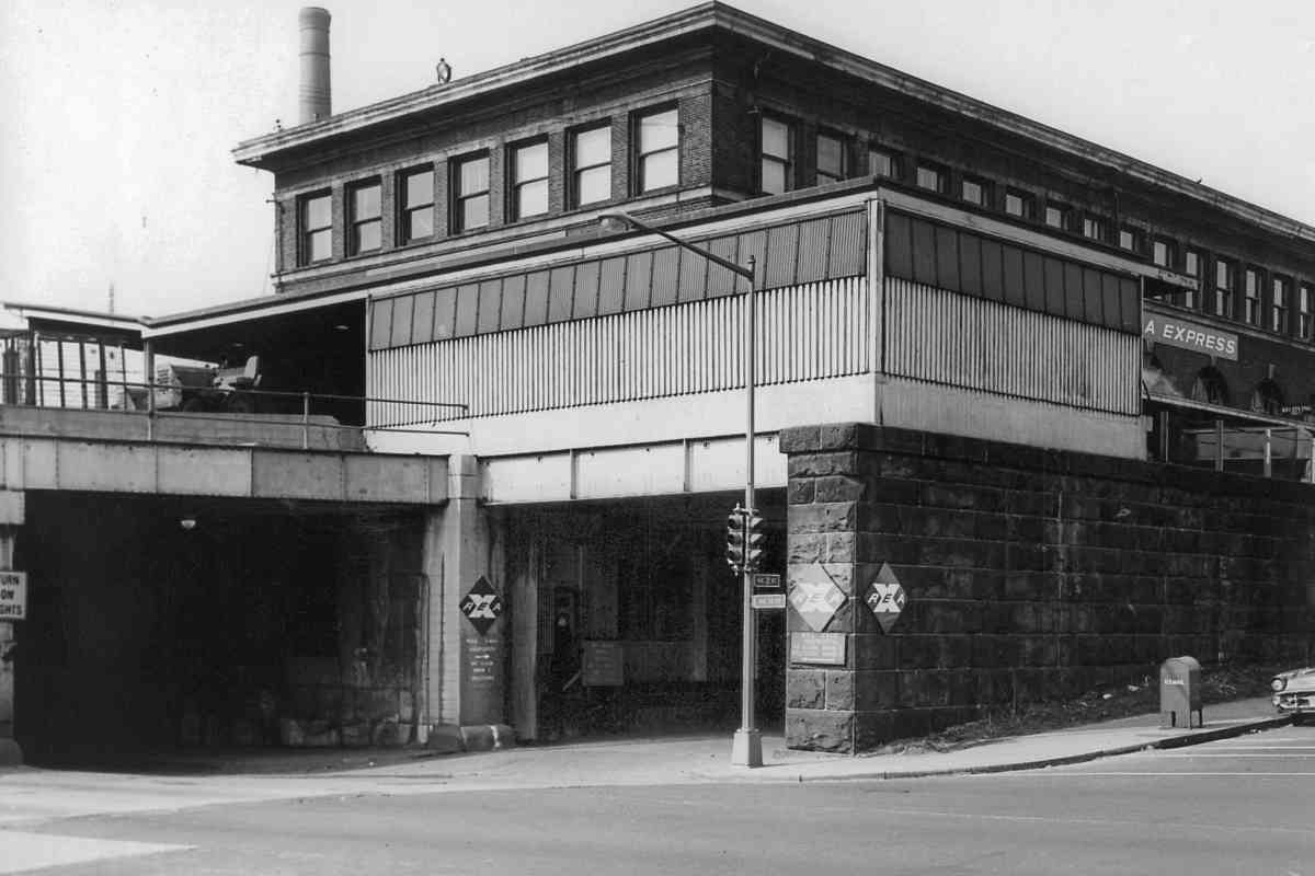
Public funding for roads and airports, plus wage/price controls took their toll on railroads. By 1974 the REA office had closed here, and the building, broken windows and all, was left to deteriorate, sadly like much of the Union Station area.

Assigning simple letter names to streets is both democratic and a way to avoid intersecting numbered roadways. In the Maspeth area of New York City, 60th Street, Avenue, Road, Drive, Lane, Place, and Court confusingly intersect each other within a stretch of less than 1000 feet. The trouble is single letters are difficult to hear distinctly, much to the chagrin of physicist Richard Feynman upon his first visit to Washington while consulting about the space shuttle Challenger disaster. For an important NASA meeting, a taxi took Feynman to what was an empty lot on 8th Street rather than the proper office on H Street.

Links: DDOT source photo, Every Street Is Named 60


Platforms 1974
Photo courtesy District Department of Transportation (DDOT) Library

Platforms 1974
Mile: 135.7 Date: Aug 1974
Ease: B+ View: W
Area: B T6:
Map: DC 16 D 1 Topographic Maps

cart and lamp The H Street bridge would soon cover this section of passenger platforms. Construction required approximately 3 years. Note the probably-original lamp pole near photo center. The zoom at right shows both the pole and a baggage cart that likely date to well before the 1970s.

Links: DDOT source photo, 1978, 1978


Looking North
Photo courtesy Library of Congress

Looking North
Mile: 136.0 Date: 1977
Ease: View: N
Area: B T6:
Map: DC 16 D 1 Topographic Maps

This is a reverse view of the construction as of 1977.

Link: LoC source photo


DC Streetcar

DC Streetcar
Mile: 135.7 Date: Jul 2019
Ease: B+ View: NE
Area: A T6:
Map: DC 16 D 1 Topographic Maps

DCSC 101B What's old is new. Streetcars of the past ran on H Street below the tracks here as part of the Washington, Baltimore and Annapolis Railway (WB&A), and as of 2016 they returned in the form of DC Streetcar. The cost of bringing streetcars back to the H Street corridor was so high (over $100 million for the first mile or so) many have questioned if it is an efficient, wise use of taxpayer money.

Change for: WB&A tour at this site
Link: similar view ~1910


MARCs

MARCs
Mile: 135.7 Date: Jul 2019
Ease: B+ View: N
Area: A T6:
Map: DC 16 D 1 Topographic Maps

As trains wiggle through switches near K Tower, when seen from afar they begin to resemble chromosomes.

Links: K Tower interior 1942, interior 2015


Switchers

Switchers
Mile: 135.7 Date: Jul 2019
Ease: B+ View: NW
Area: B T6:
Map: DC 16 D 1 Topographic Maps

Of these four switchers, the ones on the end, AMTK 597 and AMTK 599, are National Railway Equipment (NRE) model 2GS14B. Both date to the 2010s and are nicknamed Luke and Ella, respectively. In the middle, AMTK 533 and AMTK 541 are 1970-built examples of EMD model MP15DC.


MARC 24

MARC 24
Mile: 135.7 Date: Jul 2019
Ease: B+ View: NE
Area: B T6:
Map: DC 16 D 1 Topographic Maps

RR signs Diesel engines like this MARC Motive Power MP36PH-3C unit can depart Union Station and follow any of three commuter routes, the Brunswick, Camden, or Penn Line. Only the Penn Line is equipped with electric catenary.

Someone with a wry sense of humor posted a RR crossing sign within the yard.


MARC 4900

MARC 4900
Mile: 135.6 Date: Jun 1999
Ease: B View: S
Area: B IC2:
Map: DC 16 D 1 Topographic Maps

You'll note this train is not headed by a diesel locomotive. After leaving the station, it will follow the Penn Line north toward Baltimore, a direction opposite that of this tour.

During January 1953, Pennsylvania RR's runaway "Federal Express" train roared through here and rammed into Union Station, just days before crowds were expected for a Presidential inauguration.

Links: 1948, Wreck of the Federal Express, 1986 pic


Platforms 1962
Photo credit William Leffler

Platforms 1962
Mile: 135.6 Date: 1962
Ease: B View: SW
Area: B T6:
Map: DC 16 D 1 Topographic Maps

By the 1960s a confusing array of overhead semaphore signals had given way to trackside dwarf CPLs. On the right is Washington Terminal switcher model RS1 number 59.

Links: 1946, Number 59 in 1978


Platforms 1999

Platforms 1999
Mile: 135.7 Date: Jun 1999
Ease: B View: S
Area: B T6:
Map: DC 16 D 1 Topographic Maps

AMTK 941 exhibits my personal favorite paint scheme on model AEM7 engines.

Links: Walter Johnson here 1924, 1977, 1977, Amtrak ICE 1993


Platforms 2019

Platforms 2019
Mile: 135.7 Date: Jul 2019
Ease: B View: S
Area: B T6:
Map: DC 16 D 1 Topographic Maps

On both MARC 4912 and AMTK 652 the red lamps of reverse movement are illuminated, something not often seen on ACS-64 engines while they ply the Penn Line.

Links: PRR 5401 in 1929, The Senator in 1929, The Senator in 1929, 1980


Operator Cab

Operator Cab
Mile: 135.7 Date: Jul 2019
Ease: B View: E
Area: B T6:
Map: DC 16 D 1 Topographic Maps

panel A very 20th-century-looking telephone handset contrasts with the ACS-64's more modern-looking instrumentation. That speedometer registers up to 160 mph, or about 260 kph.

Yes, I was tempted to climb in the cab for a better photo, but did not wish to make anyone nervous. Security staff and cameras are numerous.


Cushy Cab
Photo courtesy Amtrak

Cushy Cab
Mile: Date: 2013
Ease: View:
Area: T6:
Map: DC 16 D 1 Topographic Maps

1953 cab Fortunately Amtrak has already done the necessary cab-climbing, and offered the main photo, the old-looking phone handset curiously absent.

Operator cabs from 60 years prior (right) were a wee bit less cushy. No cupholders back then either though.

Links: Amtrak source photo, MP54 cab 1977


<< Previous (north) | THIS PAGE: Union Station Yard | Next (south) >>

Or, return to main page

Copyright Notice