TrainWeb.org Facebook Page
B&O Photo Tour


B&O Baltimore Belt Line
Modern day photo tour

Accompanying each photo below are:

Click a photo to see a larger view. Please send your comments and corrections to Steve.


<< Previous (west) | THIS PAGE: Clifton Park to Bayview | Next (east) >>

1927 Aerial
Photo via Johns Hopkins University

1927 Aerial
Mile: 92 Date: 1927
Ease: View: N (up)
Area: RBL:
Map: Ba 35 Topographic Maps

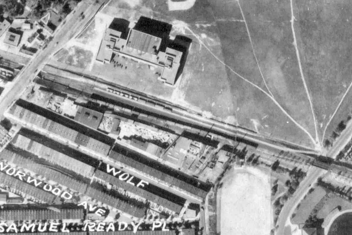
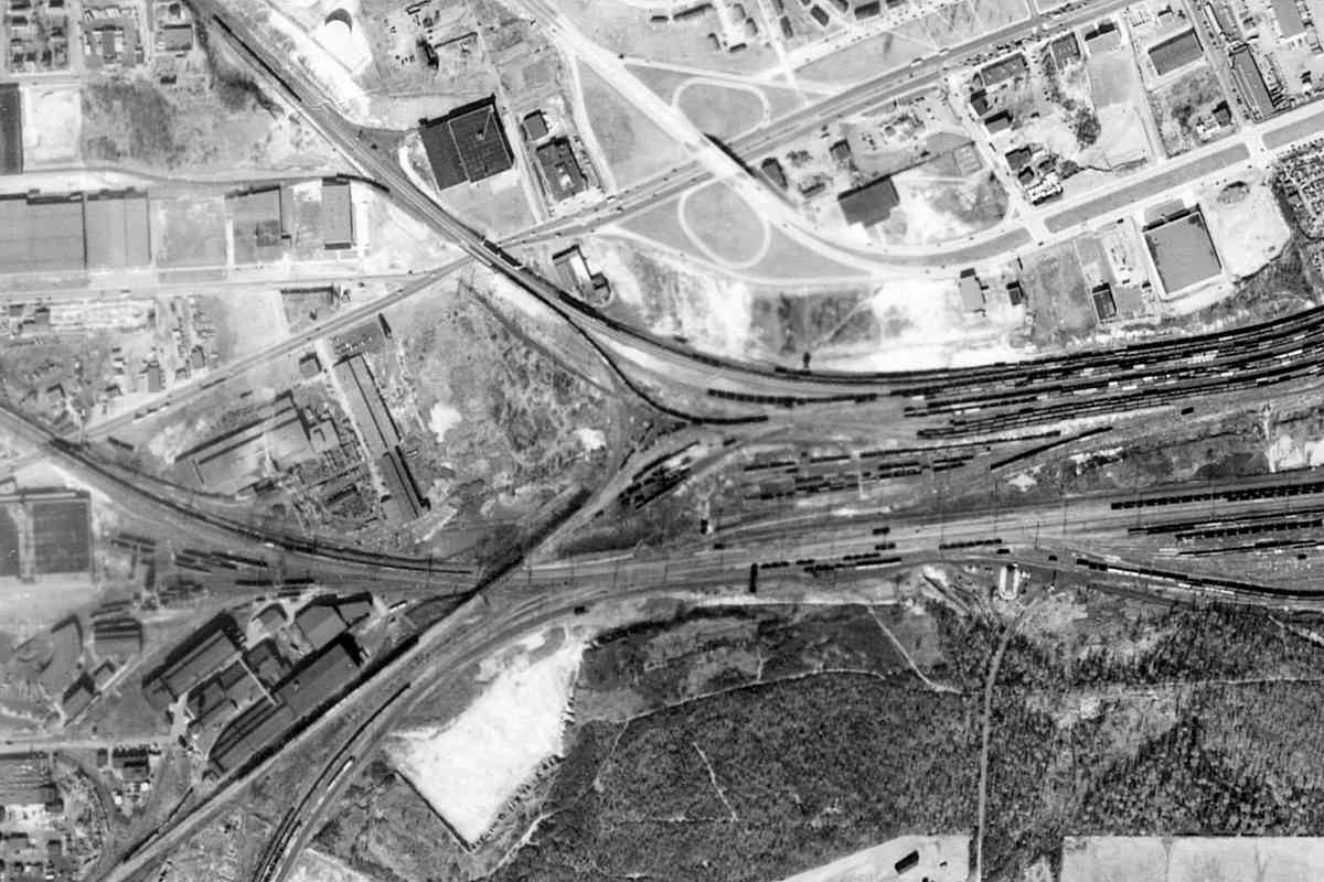
With Harford Road at upper left, this old aerial photo reveals the pre-Clough Street short siding along the southwest side of the Belt Line. St. Lo Drive is at lower right.

At upper right, Clifton Park was to be the home of Johns Hopkins University. Henry Thompson, 18th century owner of Clifton Park, served as President of the Baltimore and Harford Turnpike Company that built the adjacent Harford Road. After Thompson's death, heirs sold the property to Johns Hopkins in 1838 who in turn bequested it plus his B&O Railroad stock toward the formation of Johns Hopkins University.

Unfortunately, B&O stock was priced too low to fund new construction at Clifton, so the university was temporarily situated downtown. It moved to Homewood, JHU Gilman Hall 2004 its present Homewood location after donation of that land by heirs of Charles Carroll of Carrollton, the last living signer of the United States Declaration of Independence who on July 4, 1828 had laid the ceremonial first stone for construction of the B&O.

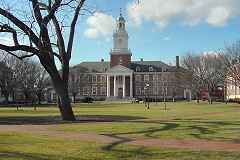
Old aerial photos indicate the tree in this 2004 campus photo's foreground predates the university's arrival. The campus name dates back to 1690 when this land was surveyed for John Homewood.

Link: Johns Hopkins biography at Wikipedia


Saint Lo Drive

Saint Lo Drive
Mile: 91.8 Date: Sep 2016
Ease: A View: N
Area: C- RBL:
Map: Ba 35 F 8 Topographic Maps

plaque Bridge 11, rebuilt by the American Bridge Company during 1929, carries trains over Clifton Park's Saint Lo Drive.

Though Clifton Lake, once a reservoir of Baltimore City's water system, was drained during the 1960s, its valve house remains, albeit in disrepair, abutting Saint Lo Drive.


CPLs
Photo courtesy Dave Hiteshew

CPLs
Mile: 91.7 Date: Sep 2009
Ease: B View: E
Area: D+ RBL:
Map: Ba 35 F 8 Topographic Maps

cpls East of St. Lo, this stately set of Color Position Light (CPL) signals had guarded the interlocking. Double track extends from here to Bayview Yard, the end point of this tour page. The CPLs have since been replaced by CSX's in-line signals.

Beyond, the sign of Goetze's Meat still stands tall even though the factory has been closed since 1974.


Goetze Siding

Goetze Siding
Mile: 91.5 Date: Aug 2016
Ease: B+ View: E
Area: D RBL:
Map: Ba 35 G 9 Topographic Maps

Goetze was large enough to warrant its own siding adjacent this trackside crumbling building. Only within the past few years has the building been broken into and become a homeless hangout. If you approach, be prepared to be growled at.

Some of the support columns look in sad shape, but they did survive the 2011 earthquake, so perhaps they have decades more to go. No stronger earthquake had occurred in the US east of the Rocky Mountains during the more than 110 years since the Belt Line was constructed.

Links: Goetze Meat, 2011 earthquake


Rose Street
NEW! mid-Oct 2024

Rose Street
Mile: 91.4 Date: Aug 2016
Ease: A View: N
Area: D+ RBL:
Map: Ba 35 G 9 Topographic Maps

Rose Street was given a wide path under the railroad in anticipation it would become a major entrance to Johns Hopkins University. But as described above, the university preferred its Homewood location, and Rose Street became a dead end. An 1882 map names this Mine Bank Lane.


Gay Street Station
Photo courtesy Baltimore Streetcar Museum
and Digital Maryland
NEW! mid-Oct 2024

Gay Street Station
Mile: 91.4 Date: 1915
Ease: A View: NE
Area: D+ RBL:
Map: Ba 35 G 9 Topographic Maps

Gay Street becomes Belair Road at the railroad. The road was being twinned along its southeast side at photo time, so B&O's bridge had to be lengthened. A United Railways and Electric (UR&E) trolley line was kept in service below. FPBW

The new bridge was built in 1914 by the Fort Pitt Bridge Works of Pittsburgh, Pennsylvania, a company that operated from 1896 until a merger with Colonial Steel in 1986. I like the plaque's sans serif, bold font, one apropos of a steel bridge works.

Link: photo source


Bridge Work
Photo courtesy Baltimore Streetcar Museum
and Digital Maryland
NEW! mid-Oct 2024

Bridge Work
Mile: 91.3 Date: 1910s
Ease: A View: SW
Area: D+ RBL:
Map: Ba 35 G 9 Topographic Maps

B&O's new Gay Street / Belair Road railroad bridge was built on this, the northeast side of the line. Information with this photo indicated that when complete, the new bridge was shifted southwest to take the place of the original. Once in place, it became the Belt Line's longest bridge that does not span water.

B&O's Gay Street Station had stood in the northeast quadrant (left), and either was removed to make room or was never much more than a small waiting shelter.

Link: photo source


Belair Road

Belair Road
Mile: 91.4 Date: Aug 2016
Ease: A View: NE
Area: D+ RBL:
Map: Ba 35 G 9 Topographic Maps

The 1914 version has remained on duty for over a century.


Work Zone
Photo courtesy Baltimore Streetcar Museum
and Digital Maryland
NEW! mid-Oct 2024

Work Zone
Mile: 91.3 Date: 1910s
Ease: View: NE
Area: D+ RBL:
Map: Ba 35 G 9 Topographic Maps

This was the view from B&O's bridge over Belair Road as trolleys of route 15 continued to run through the chaotic work zone. The quietest spot is UR&E's probably-temporary passenger waiting shelter just above photo center.

Link: photo source


Ads

Ads
Mile: 91.3 Date: Sep 2009
Ease: B View: NE
Area: D+ RBL:
Map: Ba 35 G 9 Topographic Maps

Delicious! Refreshing! Drink Coca-Cola At All Fountains. The brand's flowing font would not befit a steel bridge works. This ad dates to around 1910. Later Coca-Cola ads mention bottles as well as fountains.

The ad has outlasted the house that previously covered and preserved it. Other ads, visible to both B&O passengers and drivers on US 1 (Belair Road), have merged into a palimpsest. One topping the cola ad appears to be for biscuits, now commonly called crackers or cookies in the United States. It may have been for Uneeda Biscuit which was National Biscuit Company's (Nabisco's) first product.

Link: fading ads site


Edison Highway
Photo courtesy Maryland Historical Trust
NEW! mid-Oct 2024

Edison Highway
Mile: 90.8 Date: Aug 2016
Ease: A- View: W
Area: D+ RBL:
Map: Ba 35 H 9 Topographic Maps

Edison Highway meets Sinclair Lane above the railroad. The original road intersection was an awkward, dangerous one, so was redesigned into this form during 2016.


North Avenue

North Avenue
Mile: 90.7 Date: Aug 2016
Ease: A- View: SE
Area: D+ RBL:
Map: Ba 35 J 9 Topographic Maps

After curving under Edison Highway, the Belt Line meets North Avenue again, this time at the latter's most eastern reach (off photo right). The railroad has a lengthy straight run here. Bugle Field (baseball) had been on the right.


Federal Street
Updated mid-Oct 2024

Federal Street
Mile: 90.3 Date: Aug 2016
Ease: A View: E
Area: C- RBL:
Map: Ba 35 J 10 Topographic Maps

This underpass for Federal Street is now busy enough to warrant widening.

Hecht Warehouse At the northeast corner (left) during the 1950s, The Hecht Company department store constructed a warehouse that received an adjacent siding for deliveries via B&O. The siding is now gone -- and so is Hecht's -- while the store's painted name fades on the warehouse.


RR Crossing

RR Crossing
Mile: (90.2) Date: Aug 2016
Ease: A View: NW
Area: C- RBL:
Map: Ba 35 J 10 Topographic Maps

East of Federal Street, B&O's Columbia Siding curled into the Pennsylvania Railroad's former yard near Orangeville. The siding has not seen a train in decades, but the tracks and a unique crossing sign remain.


Forgotten Bridge

Forgotten Bridge
Mile: 90.1 Date: Mar 2020
Ease: B- View: N
Area: D RBL:
Map: Ba 35 K 10 Topographic Maps

This forgotten B&O stone bridge from the late 1800s is numbered 19 but is not marked on any map I have seen. It is aligned to permit Preston Street to pass under the railroad, but Preston Street never made it this far east. The creek in this vicinity gets its own culvert, so this bridge serves no purpose. Note: this location shows signs of being a homeless hangout.


Milepost 90
Photo courtesy Dave Hiteshew

Milepost 90
Mile: 90.0 Date: Jun 2009
Ease: B View: SE
Area: C RBL:
Map: Ba 35 K 10 Topographic Maps

At 90 miles from Philadelphia, milepost 90 gets the stencil treatment.


Columbia Siding

Columbia Siding
Mile: 89.9 Date: Aug 2016
Ease: B+ View: NW
Area: C RBL:
Map: Ba 35 K 10 Topographic Maps

B&O's Columbia Siding now ends at the red "Stop End of Track" sign. In reality, track continued beyond the sign at photo time, but was in poor condition. During the 1980s, the siding had served Continental Can Company and Westvaco. Milepost 90 peeks out at the right edge.


Macon Street
Photo courtesy Dave Hiteshew

Macon Street
Mile: 89.9 Date: Dec 2009
Ease: A View: NE
Area: C RBL:
Map: Ba 35 K 10 Topographic Maps

At Macon Street, you'll find bridge 20B, the Belt Line's only stone arch bridge under which you can drive. Note that the concrete addition reveals widening to support a third track. CSX 5316 is on top.


MoW

MoW
Mile: 89.9 Date: Aug 2016
Ease: A- View: SE
Area: C RBL:
Map: Ba 35 K 10 Topographic Maps

mow Maintenance of way is an ongoing job of all railroads. On this particular summer's day, CSX MoW units BR 9825 and MT 9524 teamed up to ensure the rails are properly spiked to the wooden ties and ballast (crushed stone) is distributed evenly.

Links: MoW pics, off site


BA Tower
Photo credit Steve Salamon
courtesy North American Interlockings
NEW! mid-Oct 2024

BA Tower
Mile: 89.6 Date: Mar 1980
Ease: B+ View: SE
Area: C RBL:
Map: Ba 36 A 11 Topographic Maps

WM 4320 pauses across from BA Tower. A CPL signal stood off photo left, but what is the black box affixed to the pole at right? Anyone know? WM 4320 became CSX 6219 but has not been spotted since 2015.

Link: source photo


New Signals

New Signals
Mile: 89.5 Date: Jul 2016
Ease: A- View: NW
Area: C RBL:
Map: Ba 36 A 11 Topographic Maps

dwarf Where BA tower previously stood, CPLs have given way to CSX's new signals. Even the dwarf signal was not spared.

Rusty rails are disused rails. Sidings like these at left had sprouted off the Belt Line at various places during the early 20th century; all but a few stragglers have since been pulled up. The leftmost one has been reactivated since photo time.

This location, at the northwest corner of Pulaski Highway, is considered one of the Belt Line's better railfanning spots, in part because one can peer the other direction into a bit of Bayview Yard.

Links: 1970s, 1990s


CSX 2239
NEW! mid-Oct 2024

CSX 2239
Mile: 89.5 Date: Jul 2024
Ease: A- View: E
Area: C RBL:
Map: Ba 36 A 11 Topographic Maps

CSX 2239, now a road slug, celebrated its 60th birthday by moving cars between reactivated local sidings and Bayview Yard with help from CSX 6470. CSX 2239 had been B&O 3543.


Over Pulaski Highway

Over Pulaski Highway
Mile: 89.5 Date: Jul 2016
Ease: A- View: SE
Area: C RBL:
Map: Ba 36 A 11 Topographic Maps

Deep zoom toward Bayview Yard finds a lonely locomotive. I-895 passes overhead beyond.


CSX 6032

CSX 6032
Mile: 89.4 Date: Aug 2018
Ease: A View: W
Area: C RBL:
Map: Ba 36 A 12 Topographic Maps

Arrival in Baltimore from the east via US 40, Pulaski Highway, will take you under this color-coordinated CSX bridge. The plaque left of B is a faded CSX sign that likely hides a B&O herald.


CSX 5325

CSX 5325
Mile: 89.3 Date: Jul 2016
Ease: A- View: NW
Area: C RBL:
Map: Ba 36 A 12 Topographic Maps

The lonely guy working on his rust, umm, tan is a GE model ES44DC built during 2006.

Link: more 5325 pics


1953 Aerial
Photo courtesy Johns Hopkins University

1953 Aerial
Mile: 89 Date: 1953
Ease: View: N (up)
Area: RBL:
Map: Ba 36 Topographic Maps

This aerial shows the Belt Line entering from upper left and feeding into a busy Bayview Yard on the right. The yard south of it belonged to the Pennsylvania Railroad and is now occupied by Norfolk Southern. More recent aerial photos will include I-895. Within a few years after this photo, B&O's bridge over Pulaski Highway would be lengthened so more lanes of autos could pass underneath.

The wye at the west (left) end of the B&O yard marks the start of the Sparrows Point Branch to Dundalk. The branch still exists but was quieted by the closure of the huge Bethlehem Steel factory at Sparrows Point.

Change for: this site's PRR/Amtrak tour from here southwest


CSX 8387

CSX 8387
Mile: 89.3 Date: Jul 2016
Ease: A- View: S
Area: C RBL:
Map: Ba 36 A 12 Topographic Maps

CSX 8387 is resting on the west leg of the wye. Note the tall catenary poles of Amtrak's Northeast Corridor in the distance, as well as CSX 2201.


Yard Office

Yard Office
Mile: 89.2 Date: Nov 2016
Ease: A View: W
Area: B RBL:
Map: Ba 36 B 11 Topographic Maps

The wye has CSX's Bayview Yard office surrounded. The view from I-895 is obstructed.

Link: Todd's Bayview page


Bayview Yard

Bayview Yard
Mile: 89.3 Date: Jul 2016
Ease: A- View: SE
Area: C RBL:
Map: Ba 36 A 12 Topographic Maps

Here's the view east into the yard from the ground...


From I-895

From I-895
Mile: 89.2 Date: Nov 2016
Ease: A View: E
Area: B RBL:
Map: Ba 36 B 11 Topographic Maps

... and from above.

Bayview was to be the eastern terminus of Baltimore's Red Line light rail project. The high cost of the project, some $3 billion, would require projected ridership fares of nearly $10 per trip just to cover the interest on bonds of that amount. And that plan called for the Red Line to cross but not connect with Baltimore's existing light rail and subway. As of this writing the Red Line project sits stopped at a red signal.

Link: Todd's Red Line page


The Belt Line meets / becomes the Philadelphia Branch here.

It also meets the Sparrows Point Branch which has its own tour.

<< Previous (west) | THIS PAGE: Clifton Park to Bayview | Next (east) >>

For more tours here now, select from the map: clickable map

Or, return to main page

Copyright Notice