TrainWeb.org Facebook Page
Old Main Line Photo Tour


B&O Old Main Line
Modern day photo tour

Accompanying each photo below are:

Click a photo to see a larger view. Please send your comments and corrections to Steve.


<< Previous (east) | THIS PAGE: disused at Ilchester, west | Next (west) >>

Temporary Bridge
NEW! Feb 2025

Temporary Bridge
Mile: 10.7 Date: May 2018
Ease: B View: NE
Area: A IC2:
Map: Ho 13 A 13, Ba 40 K 7 Topographic Maps

Underway at Ilchester, Maryland at photo time was the "Patapsco Interceptor Relocation" project, the rerouting of a sewer line as seen on the Bloede Dam removal page.

washout The project's temporary bridge across the Patapsco was just too tempting for Mother Nature who washed it away a few weeks after this photo via the Ellicott City flood of May 27, 2018. That washout is shown at right.

River Road pavement left behind by Agnes, and its yellow center stripe seen at lower left of the main photo, would be removed in 2019 as part of the project's cleanup.


Retaining Wall

Retaining Wall
Mile: 10.7 Date: May 2018
Ease: B View: E
Area: A IC2:
Map: Ho 13 A 13, Ba 40 K 7 Topographic Maps

stones B&O's retaining wall was removed again during 2018, this time by the sewer relocation project.

The retaining wall's original stones were set aside, as seen in these photos, then reinstalled.

One of the stones was found to be dated 1874, as shown below.


CHM 1874
Photo courtesy Maryland DNR

CHM 1874
Mile: (10.7) Date: Jan 2020
Ease: View:
Area: IC2:
Map: (Ba 40 K 7, Ho 13 A 13) Topographic Maps

This engraved stone was found in or near the retaining wall. Limestone like this block erodes faster than granite, so the sharpness of the inscription suggests it was either not facing outward, or had fallen face down where it sat undisturbed until discovered sometime around 2018.

A stone of a B&O bridge upstream, west of Daniels, also has the initials CHM, along with the year 1873. It seems likely CHM are the intials of one of the crew that built the bridges and/or retaining walls, perhaps a B&O employee or contractor.

Link: another CHM


Refreshed Trail
NEW! Feb 2025

Refreshed Trail
Mile: 10.7 Date: Jul 2019
Ease: B View: NW
Area: A IC2:
Map: Ba 40 K 7, Ho 13 A 13 Topographic Maps

The trail to the footbridge (distant center) was reopened during 2019. The rebuilt retaining wall is off photo left and below.


Ilchester Bollman
Photo courtesy Jeremy "Kipp" Clark

Ilchester Bollman
Mile: 10.7 Date: 1880s
Ease: View: NW
Area: A IC2: 115, 390
Map: Ba 40 K 7, Ho 13 A 13 Topographic Maps

B&O replaced its collapsed Patterson Viaduct first with a temporary wooden structure then with the iron Bollman bridge seen here. My eye reads the date on the bridge as 1869. This view is almost the same as that of the November 1999 picture farther above, yet this one appears crowded with buildings.

Immediately left of the bridge is the sunlit side of the first B&O Ilchester Station. To the left of that is George Ellicott's house and tavern. Further above are buildings of St. Mary's College. Most of these structures are now survived by little more than crumbling walls and foundations.


Ilchester Station
Photo courtesy Jeremy "Kipp" Clark

Ilchester Station
Mile: 10.7 Date: 1890s
Ease: View: SW
Area: A IC2: 115, 390
Map: Ba 40 K 7, Ho 13 B 12 Topographic Maps

When viewed from the side and above, the area appears less congested. This photo from the hillside above Ilchester Tunnel shows the original Ilchester Station, plus the riverside road that passed under the Patterson Viaduct's surviving stone arch, and George Ellicott's tavern on the right. The road was later moved higher up the embankment and today crosses where the station had been.

Also note at the shadowy extreme left edge of the photo that a steel girder bridge has supplanted the Bollman design. Such an upgrade has also been found at the OML's Monocacy River crossing near Frederick, Maryland, suggesting the Bollman design proved unacceptable for heavy use. Its iron bars had a reputation for loosening and requiring frequent readjustment. Steel is more durable than iron, so as steel's cost came down during the later 19th century, many iron bridges were swapped out for steel replacements.


Patterson Art
Image courtesy Johns Hopkins University
NEW! Feb 2025

Patterson Art
Mile: 10.7 Date:
Ease: View: S
Area: IC2:
Map: Ba 40 K 7, Ho 13 B 13 Topographic Maps

So few photos of the original Patterson Viaduct exist that people have taken to painting it. This view looks downstream.

park entrance ~1950 Jacob Bronowski considered the stone arch one of the inventions that defines humans. He devoted considerable time to it in his book and TV series The Ascent of Man.

Depicted in other art is a wagon road that crossed the river on this side of the Viaduct. Prior to the 1860s flood, a road along the Baltimore side of the river had connected Ilchester and Avalon. After the flood, that River Road was transferred to the Howard County side, the entrance to which from Ilchester is seen at right; it endured until the floods of Agnes.


Sign

Sign
Mile: 10.7 Date: ~1870 (Feb 2008)
Ease: B+ View: S (N)
Area: A IC2: 115
Map: Ba 40 K 7, Ho 13 B 13 Topographic Maps

Installed at the east end of the Patterson Viaduct is a sign describing the importance of B&O to Baltimore. It includes a circa 1870 picture that looks downstream to the then-new Bollman bridge.

Few Bollman bridges were longer than the 160 feet of this one because unequal thermal expansion of its iron segments of various lengths interfered with the bridge's stability. Even so, the longest single-span Bollman measured 360 feet as part of a Mississippi River crossing at Clinton, Iowa. The Bollman example that survives at Savage is also 160 feet long, but consists of two 80-foot spans.

Patterson's westernmost stone arch survived the floods of the 1860s. It remains extant per the next photo.

Link: The Engineering Contributions of Wendel Bollman


Patterson Arch

Patterson Arch
Mile: 10.7 Date: Jul 1999
Ease: B View: SE
Area: B+ IC2: 38
Map: Ho 13 A 13 Topographic Maps

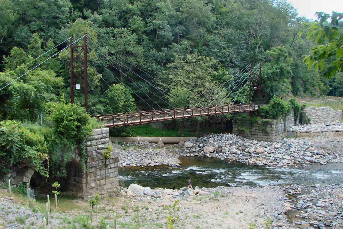
The surviving arch, pre-footbridge, was looking a bit weary by 1999.

It is here the railroad leaves Baltimore County for the first time and enters Howard County. It does so in order to switch to the opposite bank of the Patapsco. The next few miles of river upstream were lined with various mills originally sited to take advantage of free water power.

Prior to the construction of the railroad, all the mills were on the Baltimore County side of the river. They were situated so as to facilitate the transportation of their products to the port of Baltimore: by being on the Baltimore side to begin with, they would not have to haul the finished goods across the river.

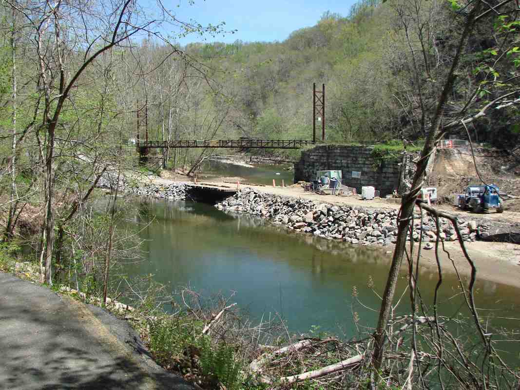
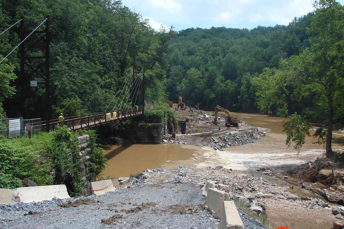
Since the mill buildings occupied the Baltimore bank of the Patapsco, B&O decided to cross the river and build on the opposite bank. One consequence was that to connect a mill to the railroad, a bridge would need to be built across the river.

The Ellicott brothers immediately recognized the importance of the railroad, and in exchange for land, convinced the B&O to build a bridge to their mill first. Records indicate the bridge was in place when the railroad began service in May 1830. A bridge (of newer construction) still exists at the site and is pictured later in this tour.


Reopened

Reopened
Mile: 10.7 Date: Jul 2019
Ease: A- View: E
Area: B+ IC2: 38
Map: Ho 13 A 13 Topographic Maps

1976 After the sewer line was relocated, the area was restored; the popular Grist Mill Trail reopened during 2019. Vines continue to overtake the Patterson's surviving arch at left. The photographer is standing at the site of B&O's first Ilchester Station as shown in a photo above. 1976 view at left of same side of the arch courtesy JD Hiteshew.


More Stringers

More Stringers
Mile: 10.7 Date: Sep 2003
Ease: A View: N
Area: B IC2:
Map: Ho 13 A 13 Topographic Maps

I brushed away leaves damp from Hurricane Isabel to reveal one of several more stone stringers in this area. Note how the original trackbed is parallel to Ilchester Road and almost perpendicular to the realigned right of way (the bridge over the road in the distance).

Ilchester Station had originally been positioned a short distance behind me, and St. Mary's College up on the hill at left.


Mount Clement
Photo credit St. Mary's College
NEW! Feb 2025

Mount Clement
Mile: 10.8 Date: 1868
Ease: B View: NW
Area: B IC2:
Map: Ho 13 A 12 Topographic Maps

George Ellicott sold the property here after he failed to convince B&O to make Ilchester (and the tavern he had constructed) a significant stop on the railroad.

The Redemptorist Order of the Catholic Church was the purchaser during 1866. Within two years they opened Mount Clement seminary, seen here when new, and transfered students from Annapolis.


Long Climb
Photo credit St. Mary's College
NEW! Feb 2025

Long Climb
Mile: 10.8 Date: ~1940
Ease: B View: W
Area: B IC2:
Map: Ho 13 A 12 Topographic Maps

St. Mary's stairway 1999 The school was renamed St. Mary's College circa 1890 after it became associated with the local parish of Our Lady of Perpetual Help.

By photo time, B&O had built Ilchester Tunnel and moved Ilchester Station to the site seen here. The college expanded via the 1934 addition of a fifth story to the main building on the hilltop at left.

It was a long climb from the station to the college via the stairs at right (1999 photo).

Link: OLPH history


Downfall
NEW! Feb 2025

Downfall
Mile: 10.8 Date: 1999
Ease: B View: W
Area: B IC2:
Map: Ho 13 A 12 Topographic Maps

After Catholicism did not evolve at the rate of society, many adherents moved on after finding the simple core value of love to be sufficient. Mass attendance declined, as did the number of men seeking the priesthood.

The Redemtorists closed St. Mary's in 1972 and sold the property soon thereafter. Plans to reuse the building as a Hindu retreat and study center fell through, leaving it unoccupied for decades. It became a favored location for haunted house adventures of local teenagers until someone ruined the fun by starting a fire in 1997.

Masonry survived the fire, but left with little bracing, it gradually collapsed in wind storms. The main photo is one of few taken after the fire but before the central statue of Mary tumbled.

Link: Atlas Obscura


St. Mary's College

St. Mary's College
Mile: 10.8 Date: Mar 2004
Ease: B View: SW
Area: B IC2:
Map: Ho 13 A 12 Topographic Maps

St. Mary's By 2004, these precarious walls threatened the safety of visitors to what hypester teens dubbed Hell House.

Howard Country debated what to do with the attractive nuisance before in 2006 finally bulldozing much of what remained standing.

Link: Maryland Historical Trust entry (PDF)


Cross River

Cross River
Mile: 10.7 Date: Dec 1999
Ease: C View: W
Area: A IC2: 203
Map: Ba 40 K 7, Ho 13 B 13 Topographic Maps

Looking from the top of Ilchester Tunnel, across the Patapsco River into Howard County, the 1902 bridge is in the foreground. The green line marks the path of the original alignment. In the center-right distance, steam from the Simkins recycling plant (formerly Thistle Mill) rises. Some of the truck trailers for recyclables are visible at left.


Ilchester Bridge
Photo courtesy HH Harwood collection

Ilchester Bridge
Mile: 10.7 Date: 1941
Ease: B View: W
Area: A IC2:
Map: Ba 40 K 7, Ho 13 B 13 Topographic Maps

This is a similar view in 1941, when Ilchester Station in its second incarnation was still standing. Upon the hill on the left, the maintained lawn of St. Mary's College can be seen, and at the left edge of the photo the base of the steps leading up to it from the station.


rejoining

Rejoining
Mile: 10.7 Date: Sep 2003
Ease: B+ View: W
Area: B IC2:
Map: Ho 13 B 12, Ba 40 K 7 Topographic Maps

Ilchester Station's concrete slab foundation is hidden within the brush on the left. The green line illustrates how the OML's original alignment had curved and where the current alignment rejoins.


<< Previous (east) | THIS PAGE: disused at Ilchester, west | Next (west) >>

Or, return to main page

Copyright Notice