TrainWeb.org Facebook Page
Maryland and Pennsylvania Railroad Photo Tour


Maryland and Pennsylvania Railroad
Modern day photo tour

Accompanying each photo below are:

Click a photo to see a larger view. Please send your comments and corrections to Steve.


<< Previous (south) | THIS PAGE: Roland Park to Towson | End of tour | main index

Aerial 1953
Photo courtesy Johns Hopkins University

Aerial 1953
Mile: 3.2 to 3.9 Date: Feb 1953
Ease: View: N (up)
Area: TM:
Map: Ba 26 K 13 (center) Topographic Maps

Ma & Pa's Notre Dame Station is the bright building left of the dark triangle at the very bottom. Charles Street is the vertical main road at right, and Roland Avenue is the one on the left.

Roland Park Siding extended about 500 feet north of Notre Dame Station on the east side of the tracks. Ma & Pa used it during the mid-1950s to drop off construction materials for the nearby Cathedral of Mary Our Queen.

Gilman Country School, as it was formerly known, is sandwiched at upper left between Roland Avenue and the thin line of Ma & Pa. The railroad crossed Belvedere Avenue (top) at grade.

Links: Ma & Pa memories, Cathedral history


Gilman School

Gilman School
Mile: 3.6 Date: Feb 2025
Ease: A View: N
Area: A TM:
Map: Ba 34 K 1 Topographic Maps

The school repurposed Ma & Pa's line as the access road on the left. Ahead, Ma & Pa turns a bit west to climb out of Stony Run's valley.

Link: school history


Northern Parkway

Northern Parkway
Mile: 3.8 Date: Feb 2025
Ease: A View: E
Area: A TM:
Map: Ba 26 K 13 Topographic Maps

Belvedere Avenue was twinned during the 1960s to become the more familiar Northern Parkway. The pedestrian bridge lies just east of where where Ma & Pa crossed Belvedere at grade.


Track Map
Image courtesy Ma&Pa RR Historical Society

Track Map
Mile: 3.5 to 4.1 Date: 1918
Ease: View: N (up)
Area: TM:
Map: Ba 26 K 13 (center) Topographic Maps

North of Northern Parkway (Belvedere), Ma & Pa ran in a cut along the west edge of Bryn Mawr School. Melrose Avenue crossed overhead via a bridge.

I suspect, but have not verified, that the stone culverts marked on this map have been lengthened subsequently such that their original masonry is no longer visible. Photos are welcome if you find one.


Homeland Station

Homeland Station
Mile: 4.3 Date: Feb 2025
Ease: A View: SE
Area: A TM:
Map: Ba 26 K 12 Topographic Maps

Homeland, the best preserved former Ma & Pa station, is now a private home where the line crossed Lake Avenue, which is seen at bottom. The tracks ran along the west side of the station.


The Elkridge Club

The Elkridge Club
Mile: 4.3 Date: Feb 2025
Ease: A View: N
Area: A TM:
Map: Ba 26 K 12 Topographic Maps

Trains ran along the raised mound at left, the western edge of The Elkridge Club's golf course. A 1928 map shows a passing siding here 884 feet in length. The Baltimore City/County line is one quarter mile ahead.

Beyond the evergreen trees right of center, the Ma & Pa line turned sharply right (northeast). It was at that curve on May 22, 1920 that the railroad experienced its worst wreck, that of a head-on collision of two trains. Crew members were killed, but the railroad kept its perfect record of no passenger deaths.

Link: The Elkridge Club


Pavement
Photo courtesy Google

Pavement
Mile: 5.1 Date: Feb 2017
Ease: View: N (up)
Area: TM:
Map: Ba 26 K 10 Topographic Maps

Ma & Pa emerged from The Elkridge Club here at Charles Street (vertical, four-lane road). Until Charles Street was repaved in 2018, old rails were visibly trapped in its pavement (photo center) adjacent to a gas station just north of Stevenson Lane. Stevenson Lane was previously named McKim Avenue here.


Sinclair
Photo courtesy Trackside Maryland

Sinclair
Mile: 5.1 Date: Sep 1952
Ease: A View: SW
Area: A- TM: 221
Map: Ba 26 K 10 Topographic Maps

This Ma & Pa train is making use of the rails across Charles Street.

Sherwood Brothers, Inc., originally an independent distributor of petroleum products in Maryland, became a wholly owned subsidiary of Sinclair Oil in 1935. Due to forced divestiture, Sinclair gas stations have not been seen in Maryland since about 1970. Who remembers the DINO soap Sinclair used to give away?

Link: DINO soap


Woodbrook Station
Photo credit John W. Barriger III*

Woodbrook Station
Mile: 5.1 Date: 1941
Ease: A- View: SW
Area: A- MP: 97, 142
Map: Ba 26 K 10 Topographic Maps

The 1914 version of Woodbrook Station later shared space with Sinclair's station on the right.

The 1941 photos on this page were taken from the end of a northbound train, which explains their reverse-to-tour-direction gaze. Esso was renamed Exxon as of January 1, 1973. "X" was the trendy letter of that era, eventually also finding its way into CSX.

Link: 1946


Gas Station

Gas Station
Mile: 5.1 Date: Jul 2024
Ease: A- View: SW
Area: A- TM:
Map: Ba 26 K 10 Topographic Maps

A similar modern view shows Sinclair is no longer present, but the Esso/Exxon station remains. Ma & Pa followed the bright driveway on the other side of Charles Street just right of photo center.


Parking Strip

Parking Strip
Mile: 5.2 Date: Jul 2024
Ease: A View: NE
Area: A- TM:
Map: Ba 26 K 10 Topographic Maps

North of the gas station, Ma & Pa's right of way, which had been double tracked here, has been repurposed into one of the narrower parking lots you are likely to encounter.


Encroachment

Encroachment
Mile: 5.2 Date: Jul 2024
Ease: A- View: NE
Area: A- TM:
Map: Ba 27 A 10 Topographic Maps

Beyond the parking, private development has encroached on the railroad's former right of way. About 1000 feet ahead, Abbey View Way has taken Ma & Pa's place and left no artifacts. Beyond that, we reach what had been Sheppard Asylum.


Atlas 1877
Image courtesy Johns Hopkins University

Atlas 1877
Mile: Date: 1877
Ease: View: N (up)
Area: TM:
Map: Ba 27 B 8 (center) Topographic Maps

This map was drawn when one of Ma & Pa's predecessors was in development. The connection shown near "Lake Sta." reflects an initial plan to share Northern Central's tracks out of Baltimore. Trains would have diverged to follow Towson Run northeast from where it meets Lake Roland.

That plan fell through only after some grading was done, as seen in the panel below. A secondary plan, labeled as "Prop Narrow Gauge R.R.", routed the line west of Sheppard Asylum. Ultimately, tracks would instead be laid along Sheppard's east side.

The junction site below "Lake Sta." is seen in the photo below.

Change for: Northern Central tour at this site


Unused Ma & Pa

Unused Ma & Pa
Mile: Date: Nov 2020
Ease: A View: E
Area: A T6:
Map: Ba 26 H 8 Topographic Maps

After a Ma & Pa predecessor graded a route from here that follows Towson Run upstream, the company went bankrupt. Some of its assets were acquired by the Baltimore and Delta Railway (B&D) who decided to instead create their own alignment, a narrow gauge one, along Stony Run as toured on the prior page. The grading along Towson Run is still visible from MD 134 as seen here.

Link: Maryland Central


Unused
Photo courtesy Google

Unused
Mile: Date: Mar 2004
Ease: View: N (up)
Area: TM:
Map: Ba 26 J 8 Topographic Maps

From MD 134 at lower left, snow highlights the unused grading as it winds upstream along the northern bank of Towson Run to Charles Street (MD 139) at upper right. Grading efforts had likely continued farther east, along present-day Towsontown Boulevard's route.

B&D's decision to instead follow Stony Run left the western part of the grading along Towson Run unused, a condition in which it still exists over 150 years later. Some maps label this the "North Central Railroad (sic) Towson Spur (unbuilt)".


Atlas 1898
Image courtesy Johns Hopkins University

Atlas 1898
Mile: 5.2 to 7.1 Date: 1898
Ease: View: N (up)
Area: TM:
Map: Ba 27 B 8 Topographic Maps

Ultimately, the railroad chose an alignment along the east side of Sheppard Asylum, now Sheppard Pratt's mental health facility in Towson.

The remainder of this tour follows Ma & Pa generally northeast to Towson Station near the circled 18 at upper right. After the map was drawn, Towson University joined Sheppard on the east and Greater Baltimore Medical Center did so on the west.

This image was created by joining together three separate maps of different scales, so some minor geographic inaccuracies are likely.

Link: Sheppard Pratt history


Dirt Path

Dirt Path
Mile: 6.2 Date: Jul 2024
Ease: A View: SW
Area: A- TM:
Map: Ba 27 B 8 Topographic Maps

Towson Center ticket stub SECU arena on the right is now Towson University Arena, a 5200-seat multi-purpose venue for sports, concerts and the like. It was known as Towson Center from its 1976 opening until 2013. Even if, like Rodney Dangerfield, Ma & Pa "don't get no respect" from bigger railroads, that has only made it more loved by railfans and historians.

A 1915 map shows a siding curving toward the arena, perhaps to Sheppard Asylum's power house. Stand-alone power houses were the circa-1900 central heating solution. Steam transported heat from a power house via pipes to radiators at many buildings, thereby removing the maintenance and dangers associated with fireplaces.


Sheppard Station Site

Sheppard Station Site
Mile: 6.2 Date: Jul 2024
Ease: A View: NE
Area: A- MP: 197
Map: Ba 27 B 8 Topographic Maps

A 1915 atlas places Sheppard Station, a passenger waiting shelter, in the southeast quadrant of where Auburn Drive (left-right) now meets Osler Drive. An emergency sign now occupies the location. The Ma & Pa line continued into the trees at center.

Links: Sheppard Station, 1942


Aerial 1927
Photo courtesy Johns Hopkins University

Aerial 1927
Mile: 6.2 to 6.5 Date: 1927
Ease: View: N (up)
Area: TM:
Map: Ba 27 B 8 (center) Topographic Maps

The sewage plant site is now occupied by the University Union building. A siding peeled to the right above the word Maryland to bring coal to the power house of Maryland State Normal School, a TU predecessor. TU's power plant remains at the same location as of 2025.


Towson University

Towson University
Mile: 6.5 Date: Jul 2024
Ease: A- View: NE
Area: B+ TM:
Map: Ba 27 C 7 Topographic Maps

Old aerial photos insist Ma & Pa ran along this Towson University (TU) path. Railroad cuts and bridges are no longer present.

Links: 1942, ~1950, TU history


Atlas 1915
Image courtesy Johns Hopkins University

Atlas 1915
Mile: 6.5 to 7.1 Date: 1915
Ease: View: N (up)
Area: TM:
Map: Ba 27 A 9 (center) Topographic Maps

We continue northeast past the power house spur to Towson Run, unlabeled on this map, through "Anderson". Towson Station is beyond at upper right along with various sidings. York Road is depicted vertically at right with two streetcar tracks.


Towson Run
Photo credit John W. Barriger III*

Towson Run
Mile: 6.9 Date: 1941
Ease: A View: SW
Area: A- TM: 182
Map: Ba 27 A 9 Topographic Maps

Looking back toward the future campus, Towson Run flowed under the tracks here. If this bridge were present today, it would span Bosley Avenue immediately south of Towsontown Boulevard. Towson Station is a short distance behind the photog.

Link: 1942


Towson Station
Photo credit John W. Barriger III*

Towson Station
Mile: 7.0 Date: 1941
Ease: A View: W
Area: A- TM: 144, MP: 153
Map: Ba 27 C 7 Topographic Maps

Ma & Pa's Towson Station stood in the southwest quadrant of what is now West Susquehanna Avenue and Towson Row. This version was built in 1921 after the original burned down the year before. The grade crossing with West Susquehanna Avenue is seen here.

The station was painted yellow. Its yellow-on-red signage was similar to that of Pennsylvania Railroad. After train service ended, the building was reused to hold auctions.

Link: 1940


Last Towson Run
Photo courtesy CT Mahan
and
The Ma & Pa by George W. Hilton

Last Towson Run
Mile: 7.0 Date: Jun 1958
Ease: A View: W
Area: A- TM: 144, MP: 153
Map: Ba 27 C 7 Topographic Maps

The final run to Towson was led by M&P 82 (as painted) on June 11, 1958. This train would retrieve empties during its return trip to Baltimore that evening. With that, Ma & Pa revenue operation in Maryland ceased. Just six weeks earlier, B&O had ended passenger service north of Baltimore. Ma & Pa's last passenger train operated August 31, 1954.

Links: in color, this unit in 2021


Aerial 1938
Photo courtesy Johns Hopkins University

Aerial 1938
Mile: 6.9 to 7.1 Date: Apr 1938
Ease: View: N (up)
Area: TM:
Map: Ba 27 C 7 Topographic Maps

The trip from Baltimore up to Towson Station (center) required 20 to 25 minutes but somewhat less in the opposite (downhill) direction.


BTC 7334
Photo credit ES Miller

BTC 7334
Mile: 7.1 Date: May 1951
Ease: A View: NE
Area: A- BSTPY: 95
Map: Ba 27 D 7 Topographic Maps

Southbound BTC 7334 rolls under Ma & Pa's York Road bridge; Catonsville was route 8's other terminal. The circular symbol left of the clearance sign is Ma & Pa's logo.

Links: 1950s, 1958 color


Over York Road
Photo credit John W. Barriger III*

Over York Road
Mile: 7.1 Date: 1941
Ease: A View: W
Area: A- TM: 144
Map: Ba 27 D 7 Topographic Maps

This older, quieter York Road view from track level shows the postwar automobile boom was yet to materialize. Ma & Pa's bridge over York Road is near center.


This Stop: The Future

This Stop: The Future
Mile: 7.1 Date: Jul 2024
Ease: A View: W
Area: A- TM:
Map: Ba 27 D 7 Topographic Maps

Via a photographic time warp, we can peer into Towson 80 some years later. Yes, this really is a similar view to that of the prior panel, though from Towsontown Boulevard street level. The gray building left of center is a Hampton Inn that occupies the site of Ma & Pa's Towson Station.

What's that stone wall at right?


Memories

Memories
Mile: 7.1 Date: Jul 2024
Ease: A View: NW
Area: A- TM:
Map: Ba 27 D 7 Topographic Maps

Towson has retained a stone pier of the railroad bridge in memory of Ma & Pa. The plate girder portion was removed in 1959. Emons Industries acquired what remained of Ma & Pa in 1971.

Link: plaque


Beyond
Photo credit John W. Barriger III*

Beyond
Mile: Date: 1941
Ease: View:
Area: TM:
Map: Topographic Maps

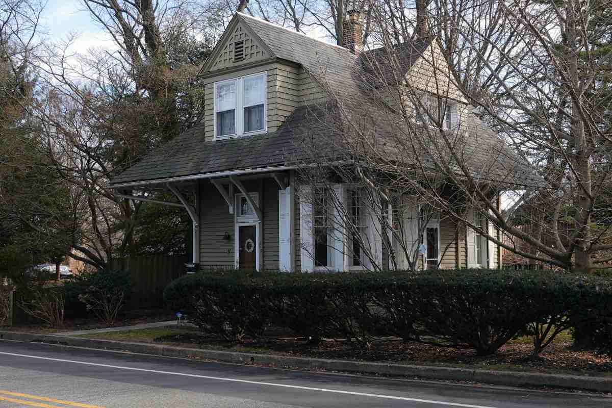
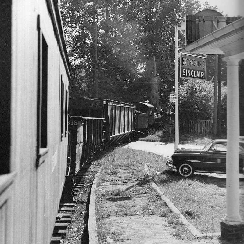
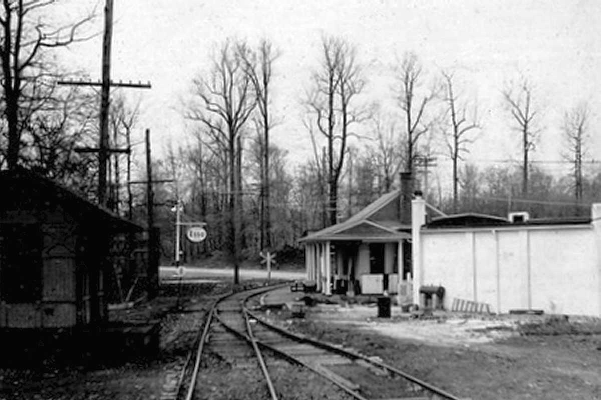
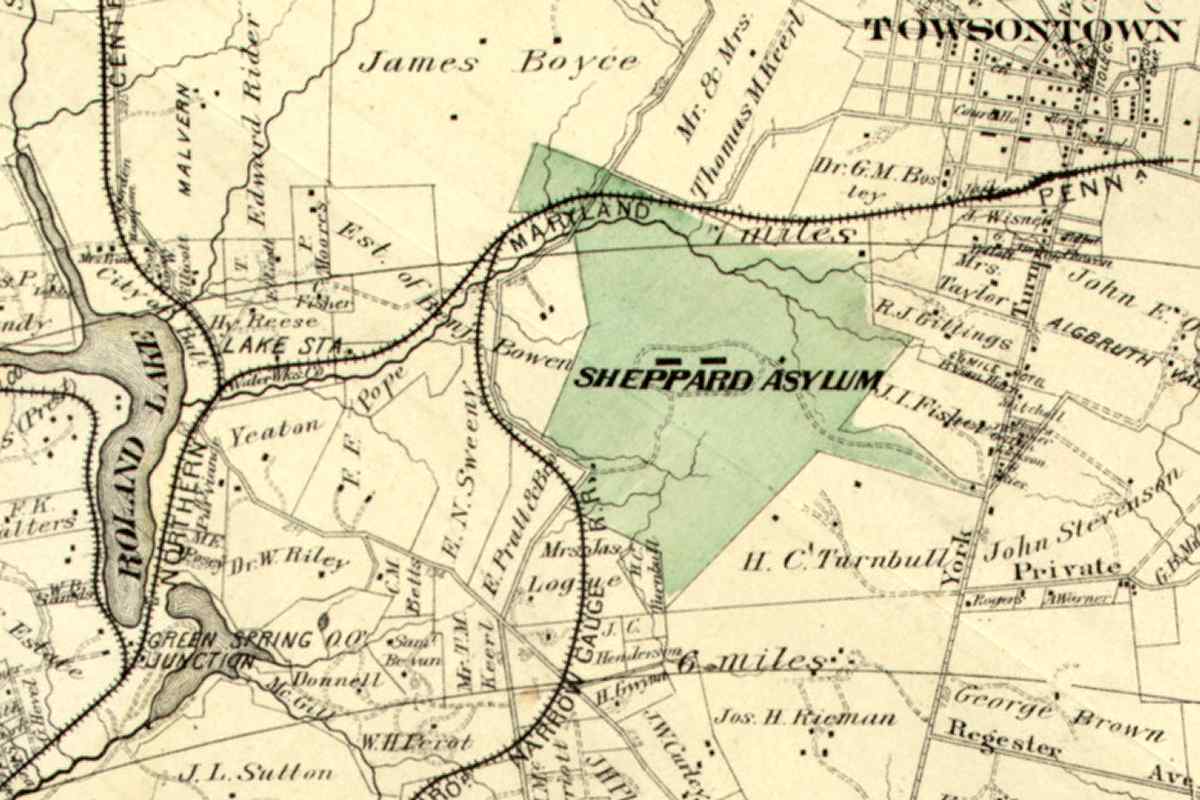
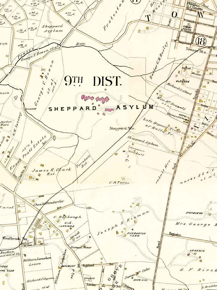
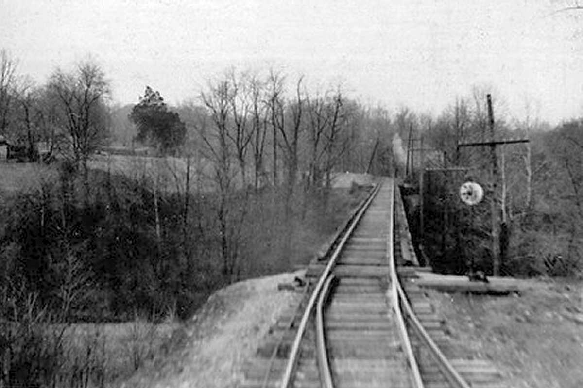
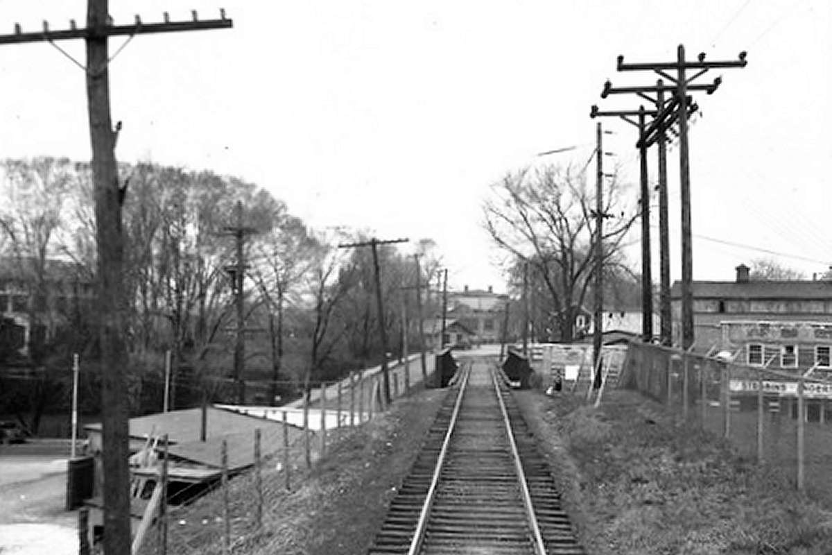
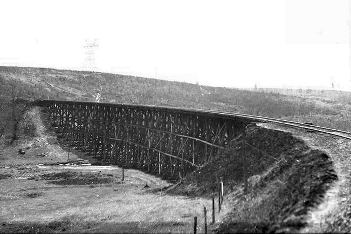
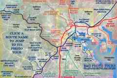
From Towson, the railroad wandered northeast via a notoriously-winding route to Bel Air, spanning several wooden trestles in the process. This unidentified photo depicts Gross Trestle near Fallston. At Bel Air, the line turned north to Delta, PA, then northwest to York, PA.

In 1999, Genesee & Wyoming began acquiring Ma & Pa trackage in Pennsylvania. They continue to operate it as of 2025 under the name York Railway (YRC). YRC exchanges railcars with both CSX and NS.

O. H. Nance, President of both Ma & Pa and Canton Railroad, dreamed of connecting the two. Routes were surveyed but nothing was built.

Detour: Canton Railroad tour at this site


<< Previous (south) | THIS PAGE: Roland Park to Towson | End of tour | main index

For other tours here now, select from the map: clickable map

Or, return to main page

* John W. Barriger III photos © 2005 St. Louis Mercantile Library at the University of Missouri St. Louis
Copyright Notice