TrainWeb.org Facebook Page
B&O Georgetown Branch Photo Tour


B&O Georgetown Branch
Modern day photo tour

Accompanying each photo below are:

Click a photo to see a larger view. Please send your comments and corrections to Steve.


<< Previous (east) | THIS PAGE: Mile 2 to 3 | Next (west) >>

Path
Photo courtesy Dave Hiteshew

Path
Mile: 2.0 Date: Nov 2008
Ease: B View: SW
Area: A IC2:
Map: Mo 36 C 10 Topographic Maps

West of Connecticut Avenue, the Capital Crescent rails-to-trails path quickly goes bucolic on us. But wait, what's that at the far left?

Link to older pic: 1956


Siding
Photo courtesy Dave Hiteshew

Siding
Mile: 2.0 Date: Nov 2008
Ease: B View: S
Area: A IC2:
Map: Mo 36 C 10 Topographic Maps

Good eye, it's an abandoned siding. This siding marks the initial goal of the Georgetown Branch: coal delivery to the power house of the Chevy Chase Lake & Kensington Railway trolley.

Link to older pic: 1972


Fence
Photo courtesy Dave Hiteshew

Fence
Mile: 2.1 Date: Nov 2008
Ease: B View: SW
Area: A IC2:
Map: Mo 36 C 10 Topographic Maps

Another fenced section... gotta keep Columbia Country Club golfers from escaping.

And, lookie what we have here: another small concrete box. Want to trade the curtain for what's inside the box? Yes, you say? OK...

Link to older pics: 1947, 1971, 1976


Inside
Photo courtesy Dave Hiteshew

Inside
Mile: 2.1 Date: Nov 2008
Ease: B View: NE
Area: A IC2:
Map: Mo 36 C 10 Topographic Maps

Looks like a zonk! Electrical terminals with wiring, and what would appear to be a battery. Shh, don't tell anyone there's also a scroll of secret information from a CIA operative, or maybe it's a Starbucks coffee cup. Either way, just pretty normal stuff for the DC area.


Chicago
Photo courtesy Dave Hiteshew

Chicago
Mile: 2.1 Date: Nov 2008
Ease: B View: NE
Area: A IC2:
Map: Mo 36 C 10 Topographic Maps

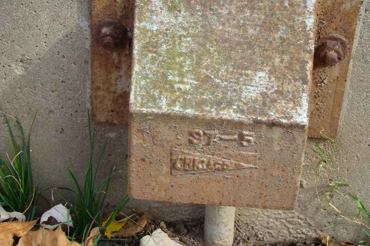
On the outside of the box, this Chicago pennant logo almost certainly represents the manufacturer, probably one of railroad equipment, possibly the Chicago Railroad Signal and Supply Company. Anyone know? Those names are so generic they make for difficult web searching.

The 97-5 reflects a forging date of May 1897, which matches the time period B&O was building the line here. Two year digits were displayed because, well, there wasn't much concern about confusion with railroad equipment from the 1700s.


East West Highway
Photo courtesy Dave Hiteshew

East West Highway
Mile: 2.8 Date: Nov 2008
Ease: B View: SW
Area: A IC2:
Map: Mo 36 B 11 Topographic Maps

A surprisingly boring stretch jumps us about three-quarters of a mile to the bridge for East-West Highway at a spot between Chevy Chase and Bethesda: the zip code border follows the railroad here.

Link to older pic: 1970s


Railfan Condos
Photo courtesy Dave Hiteshew

Railfan Condos
Mile: 2.8 Date: Nov 2008
Ease: B View: W
Area: A IC2:
Map: Mo 36 B 11 Topographic Maps

Yes, even well-to-do railfans need a place to live. Then somebody took their trains away.


Ties
Photo courtesy Dave Hiteshew

Ties
Mile: 3.0 Date: Nov 2008
Ease: B View: W
Area: A IC2:
Map: Mo 36 B 12 Topographic Maps

The trail gets a lot of use, and here has worn down to the ties.


Wisconsin Avenue
Photo courtesy Dave Hiteshew

Wisconsin Avenue
Mile: 3.1 Date: Nov 2008
Ease: B View: SW
Area: A IC2:
Map: Mo 36 A 12 Topographic Maps

At Wisconsin Avenue, the real estate is valuable enough to make the tracks worth covering over. I have not yet learned the year this grade separation was built.

Link to older pic: 1972


Tunnel
Photo courtesy Dave Hiteshew

Tunnel
Mile: 3.2 Date: Nov 2008
Ease: B View: W
Area: A IC2:
Map: Mo 36 A 12 Topographic Maps

The quasi-tunnel is about 1000 feet in length. When the tour resumes, we'll climb back out into the daylight.


<< Previous (east) | THIS PAGE: Mile 2 to 3 | Next (west) >>

Or, return to main page

Copyright Notice