|
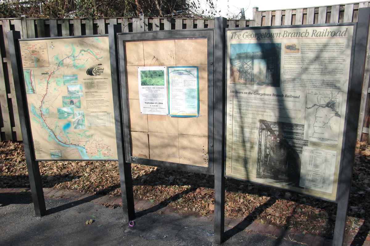
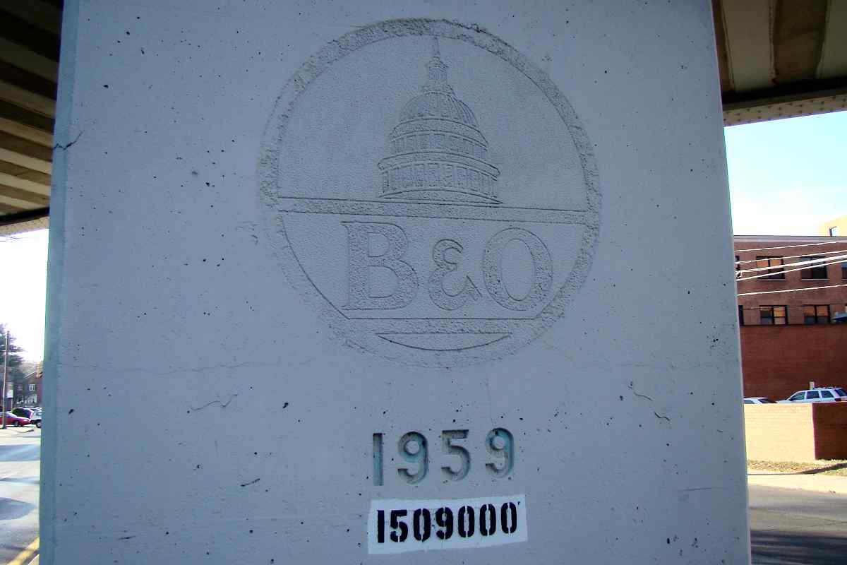
This sign describes the history of B&O in the area:
"The Capital Crescent Trail follows the route of an
old railroad line called the Georgetown Branch of the Baltimore and Ohio (B&O).
It's all that remains of an unrealized attempt by the B&O to construct a major rail
link between the Baltimore-Washington area and southern states. Had it been
successfully developed, this part of the Washington area might look very different
today.
"In the late 1880s, the B&O was eager to capture more business in southern states
but lacked a good Potomac River crossing and rail connections. The Pennsylvania
Railroad, a major competitor also wanting more southern business, had restricted
access to its bridge and rail links. B&O devised a plan to build a rail line to
connect its Metropolitan Branch line in Silver Spring, Maryland to northern
Virginia by bridging the Potomac near Chain Bridge and linking up with the
southern lines at Fairfax Station and at Quantico.
"In the early 1900s the railroad competitive atmosphere stabilized somewhat, and
the B&O was able to use the Pennsylvania Railroad's route through Washington
into Virginia, eliminating the need for a separate and costly B&O line. The
proposed bridge and Virginia section were never built. After overcoming financial
difficulties in the 1890s, the B&O completed the line from Silver Spring to
Georgetown in 1910 and named it the Georgetown Branch.
"The single-track Georgetown Branch was never intended to carry passengers but did
a fair business hauling freight - mainly coal to Georgetown and building supplies to
Chevy Chase and Bethesda. Demand declined steadily after World War II and few trains
ran on the line after 1980. The B&O was taken over by the Chesapeake and Ohio
Railway in 1963, which in turn was acquired by the CSX Corporation in the
1980s. The last train on the Georgetown Branch ran in 1985 and CSX sought to
abandon the line in 1986. Local interest in preserving the corridor led to its
development as the Capital Crescent Trail, a rails-to-trails project."
The 100 YEARS ON THE GEORGETOWN BRANCH RAILROAD timeline reads:
- 1888 � B&O Railroad developed the concept of creating a railroad line that
would connect its Metropolitan Branch with two Virginia lines, crossing the
Potomac River near Chain Bridge. Georgetown Barge, Dock, Elevator and
Railway Co. formed in Georgetown.
- 1889 � The Washington and Western Maryland Railroad formed for the section
from Delacarlia to the Aqueduct Bridge.
- 1890 � The Metropolitan Southern subsidiary of the B&O Railroad formed for
the Maryland section, and the Metropolitan Western subsidiary formed for the Virginia
section. One mile section of rail completed from Rock Creek to the Aqueduct Bridge.
- 1891 � The B&O Railroad takes over the Georgetown Barge, Dock, Elevator &
Railway Co.
- 1892 � Two miles of track laid from the junction with the B&O Metropolitan
Branch in Linden to Chevy Chase, including the 1400 foot-long wooden trestle
over Rock Creek.
- 1895 � The Arizona Avenue trestle is built over Canal Road and the C&O Canal.
- 1904 � The Rock Creek trestle is rebuilt and shortened by 281 feet in length
by adding fill on either end.
- 1906 � Plans for a crossing of the Potomac River near Chain Bridge and
connection with railroad lines in Virginia abandoned.
- 1909 � Metropolitan Southern Railroad completes additional 4.5 miles from Chevy
Chase to the District line, including Delacarlia Tunnel.
- 1910 � Georgetown Branch is completed and operated by the B&O Railroad.
- 1914 � Tracks temporarily extended across Rock Creek to bring limestone for
the construction of the Lincoln Memorial.
- 1928 � Rock Creek trestle rebuilt again, reinforced with steel girders on the
central span.
- 1942 � A flood washes railroad cars into the Potomac River in Georgetown.
- 1967 � Major fire burns portion of Rock Creek trestle.
- 1972 � Rock Creek trestle rebuilt after damage by hurricane Agnes.
- 1980 � CSX Corporation formed and absorbed the Chessie System railroads,
which had taken over the B&O Railroad in 1963.
- 1985 � Last train runs on the Georgetown Branch.
- 1986 � Application is filed with the Interstate Commerce Commission (ICC)
for abandonment of the Railroad.
- 1988 � ICC issues a certificate of Interim Trail Use for the Montgomery
County section.
There are some inaccuracies in the above sign's timeline. For example,
Chessie System did not "take over the B&O" in 1963 but rather C&O and B&O
became affiliated.
|