TrainWeb.org Facebook Page
ASL Photo Tour


Annapolis Short Line
Modern day photo tour

Accompanying each photo below are:

Click a photo to see a larger view. Please send your comments and corrections to Steve.


<< Previous (south) | THIS PAGE: Marley to Ferndale | Next (north) >>

B(urm)A Shave

B(urm)A Shave
Mile: 13.0 Date: Mar 2018
Ease: A- View: NW
Area: A EH:
Map: AA 8 D 8 Topographic Maps

B&A Shave? If you are too young to have seen steam engines in regular use, you may not know of Burma-Shave, which is remembered for advertising its shaving cream via widely-spaced road signs like these -- except Burma-Shave's jingles typically rhymed, even when they had nothing to do with shaving cream, for example:

    He saw
    The train,
    And tried to duck it.
    Kicked first the gas,
    And then the bucket.
    Burma-Shave

Beyond these signs the trail veers sharply left to get around Marley Station Mall that was built atop the right-of-way.

Link: more Burma-Shave jingles


Pumphrey's Field
Photo courtesy Johns Hopkins University

Pumphrey's Field
Mile: 13.3 Date: 1938
Ease: View: N (up)
Area: EH:
Map: AA 8 C 7 Topographic Maps

Before the mall arrived, MD 100 did so during the 1960s while B&A trains were still venturing this far south. Now the trail goes over MD 100 via bridge, then around the mall on its west side. The background of this map dates to 1938, about 10 years after Richie Highway was built. The future mall's perimeter road is traced in brown.

For this section of the tour, long-time local resident William Glover has kindly shared various memories of the B&A from his youth. He writes:

    "I see Route 100, and above that is what we called Pumphreys Field. Was that the true name, I have no idea. You can see the house and silos on the left, near where Marley Station Road meets the railroad. Played pick-up games of baseball in the open field here during the summer. The lay of the land was a gradual slope toward the tracks, which ran thru what I'll call a half cut: we had to climb a hill of about 10-15 feet to get from the tracks to the field and on the station side of the tracks there was no embankment at all.

    "The station is in the right place but a structure behind the station I really don't know, I have no memory of that at all. One other tidbit, yes the B&A crossed Route 100 at grade with gates and signals."


Parking Lot

Parking Lot
Mile: 13.3 Date: Mar 2018
Ease: A View: SE
Area: A EH:
Map: AA 8 C 7 Topographic Maps

The utility poles illustrate the original route right up to the mall's south side parking lot.


Marley Station Mall

Marley Station Mall
Mile: 13.3 Date: Mar 2018
Ease: A View: NW
Area: A EH: 76
Map: AA 8 C 7 Topographic Maps

Looking the opposite direction finds a white stripe (middle) that happens to approximately trace the ASL right-of-way. The railroad Marley Station had been located near the Macy's name.

William Glover says:

    "Marley Station Road's intersection with Richie Highway was moved when the mall was built so if you line up with the pole line (row) while facing Richie Highway with the mall at your back I estimate if you move 100 yards right of where the intersection is now, that would put you on the station. I remember it to be not much more than a freight shed with a side track on which sat the oldest wooden flat car that I ever saw. Both were overgrown with weeds and were unused at this time (1960s). The station sat on the Richie Highway side of the single track."

Link: station ~1950


Marley Creek
Photo credit John J. Bowman

Marley Creek
Mile: 13.7 Date: Aug 1935
Ease: B+ View: NW
Area: A- EH:
Map: AA 8 C 7 Topographic Maps

This photo from the WB&A era purports to look north near Marley. The siding suggests it was near the railroad's Marley Station, which was at the Macy's (south) side of the mall, however the curve ahead suggests the photo was north of the mall.

William Glover explains the siding was lengthy:

    "As a train fanatic I noticed that there were two sets of rails embedded where Marley Station Road crossed over the tracks, so it was definitely double tracked along here at some time and became single tracked right before the curve at Marley Creek.

    "Also note the post in the ground to the right of the switch. In 1970 there was a unused but fully intact, though rusted, signal along here right about where I suspected the second track started. This could be the spot."


Trail Bridge

Trail Bridge
Mile: 13.7 Date: Mar 2018
Ease: B+ View: NW
Area: A- EH:
Map: AA 8 B 6 Topographic Maps

At roughly the same spot as the 1935 photo above, History Marker S now stands off photo left. The trail spans Marley Creek via what appears to be an authentic, old bridge recycled from elsewhere. The bridge is not sturdy enough to have carried main line steam locomotives, and perhaps not even the comparatively light interurban cars. This may have instead been an automobile bridge. Columbia Pike at Patuxent River 1933

This design was a popular one during the first half of the 20th century. The photo at right from 1933 (photographer unknown) shows a similar bridge carried Columbia Pike across the Patuxent River. The view looks north from Montgomery County to Howard County. Now these stone supports are under water held behind Rocky Gorge Dam, and US 29 spans the river a short distance upstream.

William Glover reports:

    "It's been years since I walked the tracks at this very spot and you are correct that this bridge is not original and as a matter of fact there was never a rail bridge here at all..."


Washed Out

Washed Out
Mile: 13.7 Date: Mar 2018
Ease: B View: NW
Area: A- EH:
Map: AA 8 B 6 Topographic Maps

William Glover continues:

    "There was a fill here and at stream level there was a stone, not concrete, culvert of approximately four by four feet. A friend of mine crawled through once but I was too scared to follow him, there were snapping turtles as big as trash can lids in the rail pond that this fill created. (This is only one of the three branches of the creek that went under the tracks between the Harundale Mall and here.) There were two wooden trestles that were taken out during the flood control projects of the early 1960s and replaced by fills but this was not one of them.

    "Also, you have found here what became an end point of the B&A. In the spring of 1972 the B&A was on its last legs as I was graduating high school in Glen Burnie and we stones had a terrible storm named Agnes. The pond that the B&A fill created here became a small lake and Mother Nature took care of the rest. Within days erosion and water pressure ate away at the culvert and the fill collapsed and was washed out never to be repaired thus ending this railroad's route farther south.

    "Look at the bottom right, to the right of the shopping cart, (this is a far cry from what it used to look like here) what I want to see are the granite stones that were the top of the collapsed culvert. What do you think?"


Saunders Range 1950
Photo credit HH Harwood

Saunders Range 1950
Mile: 14.8 Date: Jan 1950
Ease: A- View: NW
Area: B+ EH:
Map: AA 8 A 4 Topographic Maps

During 1950 Harwood captured this B&A fan special at Saunders Range, named for a military and police trainee rifle range than opened in 1904 just north of Marley. Who knew ASL was "eccentric"?

The Baltimore Sun of June 16, 1907 reported:

    "MYSTERIOUS BOMBARDMENT OF AN ANNE ARUNDEL FARM -- Mr. Osbourn S. Pumphrey, of Marley, Anne Arundel county, is afraid that he will have to abandon the estate on which his family has lived for more than 150 years because of misdirected shots from the Maryland State rifle range at Saunders Station, three miles away. Altogether, if the present state of affairs keeps up, Mr. Pumphrey thinks that he will have to dispose of his farm and move to a locality out of reach of the modern rifle and the modern soldier.

    "The best way to get from Marley to Saunders Range is to walk up the track of the eccentric Annapolis Short Line railroad. After 15 minutes' meandering one will come to the outskirts of the range. One will see to the right hand side of the railroad a huge sign of white and red."


Saunders Range 2018

Saunders Range 2018
Mile: 14.8 Date: Mar 2018
Ease: A- View: NW
Area: B+ EH:
Map: AA 8 A 4 Topographic Maps

As of 2018 the house at left was still standing, and except for the lack of railroad, the site along Greenway Road near Greenway Village Place looks much the same.

William Glover recalled:

    "The train never went very fast, just crept along slowly, and never ran on Saturday or Sunday, and never at night. You could set your watch by the train heading down to Annapolis around 10:30 am and returning around 2:30-3:00 pm before school let out. One Saturday I remember being surprised hearing the train coming, from my house you could hear the train blowing its whistle crossing Crain Highway and for the other road crossings before getting to Norfolk Road, so I always had a few minutes to get down to the tracks, and to my amazement the only passenger train I ever saw past the Haurandale Mall went by. Not a real passenger train, just a few open air cars with people waving, pulled by old 50, it had to be some sort of tourist outing heading toward Annapolis."


Glen Burnie Station 1950
Photo credit R.W. Janssen

Glen Burnie Station 1950
Mile: 15.4 Date: Feb 1950
Ease: A View: NW
Area: B+ EH:
Map: AA 7 K 2 Topographic Maps

At Glen Burnie, a little girl waves bye bye to B&A car 103 that will soon retire from B&A passenger service.

WB&A's largest stations, including Glen Burnie's, had a restaurant within or nearby.

Link: WB&A Restaurant


Glen Burnie Station 2018

Glen Burnie Station 2018
Mile: 15.4 Date: Apr 2018
Ease: A View: NW
Area: B+ EH:
Map: AA 7 K 2 Topographic Maps

Some 68 years later that little girl has retired too. The utility pole at left remains on the job though to anchor the then-now comparison. A parking lot for the Crain Station building (right) occupies the site of the B&A's station.

At this location William Glover recalled:

    "A story that my father told me - One day he was drinking with work buddies at the Paddock Bar, at the corner of Crain Highway and Baltimore Annapolis Boulevard, where the apartment building is now, it's a block away from the B&A's crossing with Crain Highway, when they noticed that the train was blowing its horn over and over. After a few minutes of this a couple of them went down to the tracks to see what was up. One of them came back to tell my Uncle Ike that his car was blocking the tracks!!!! Just a bumper mind you but the train could not pass. Here's how. Look at the Glen Burnie 2018 photo. In the 'sixties, Green way duckpin bowling alley was the building across the street from Crain Station. Now notice the white van parked next to that building. That's how they parked in the day of the B&A but no fence or curb so he just backed his car in and headed for the bar down the street."

Links: more station photos, 1981


Crain Highway 1940s
Photo courtesy HH Harwood collection

Crain Highway 1940s
Mile: 15.4 Date: 1940s
Ease: A View: SE
Area: B+ EH:
Map: AA 7 K 2 Topographic Maps

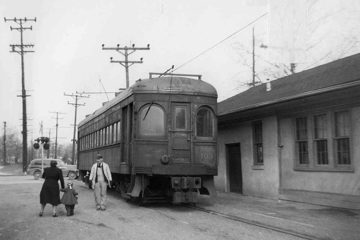
There's lots going on in this photo as passengers board B&A car 93 in Glen Burnie, plus several history mysteries.

The sign "South Shore Motor Bus Leaves From This Station" refers to B&A buses cycle that replaced the WB&A's South Shore rail service that had until 1935 followed the A&ER rails to Annapolis along the south shore of the Severn River. That bus route is now approximately retraced by I-97.

The "White House Signs" on the trashcan may be the name of a local sign-making company, and the number 600 their telephone on the Glen Burnie exchange.

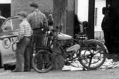
Can anyone identify the model of motor bike in the photo? What about the name of the cab company?

Link: station 1961, color


Crain Highway 2018

Crain Highway 2018
Mile: 15.4 Date: Apr 2018
Ease: A View: SE
Area: B+ EH:
Map: AA 7 K 2 Topographic Maps

Again utility poles help us match up the then and now scenes. In this view direction the buildings at right help as well. The station had been where Post 40 Road, Central Avenue, and Crain Highway meet in Glen Burnie.

More from William Glover:

    "At each major crossing the fireman (always 2 men on B&A 50 and no caboose) would get off in front of the train and walk ahead, crossing the road making sure that the traffic (very little traffic compared with today) was stopped. Crossings were guarded by the same type of signage as in the Severna Park station photo. Only 100 and 695 had gates and signals that I know of."


Dorsey Road

Dorsey Road
Mile: 16.1 Date: Mar 2018
Ease: A View: SW
Area: B EH:
Map: AA 7 J 1 Topographic Maps

At Dorsey Road, Maryland 176, the B&A trail ends because the old ASL route is now plied by Baltimore Light RailLink.

More William Glover memories:

    "I remember sitting in class one morning and hearing a loud BANG!!! A large truck got stuck underneath the train bridge that crossed over Dorsey Road. More than one truck got stuck under that bridge through the years."


Bumpers

Bumpers
Mile: 16.1 Date: May 1999
Ease: A- View: SE
Area: B EH:
Map: AA 7 J 1 Topographic Maps

Baltimore Light RailLink ends at the bumper posts... for now. The track has clearly been configured to permit future expansion southeast.

William Glover again:

    "Trains coming or going between Cromwell and Annapolis rarely had more than 3 box cars at a time, I don't remember seeing more than 5 or 6 cars ever. It was not unusual to see (B&A engine number) 50 run back or forth from Annapolis by itself. Coal cars went no further than Heins brothers, now SMO, at Dorsey Road. Sometimes I saw empties left at the Fifth Avenue runaround."


Cromwell Station

Cromwell Station
Mile: 16.2 Date: May 1999
Ease: A- View: SE
Area: B EH:
Map: AA 7 J 1 Topographic Maps

Light rail service began at Cromwell (north Glen Burnie), the southernmost of the system's stations, on May 20, 1993. Light rail cars like MTA 5018 were built by ABB Traction, the U.S. division of Asea Brown Boveri, as seen here in their original livery.

William Glover explained:

    "While switching cars at the industries at Cromwell, the (B&A) train with 2 or 3 box cars in tow, moving in the direction of Glen Burnie, would uncouple the cars before the switch into the industry, then speed up passing the switch with the engine, throw the switch, then allow the box cars to slowly free roll into the siding while stopping and backing up the engine to put the cars in their proper places. There were two runaround tracks - one in front of the Ferndale Fire Department the other was at the station ruins at the Fifth Avenue crossing in Glen Burnie."


Maintenance Facility

Maintenance Facility
Mile: 16.2 Date: Oct 2017
Ease: A View: W
Area: B EH:
Map: AA 7 J 1 Topographic Maps

Car storage and maintenance facilities are often found at the terminals of commuter rail lines, and Baltimore Light RailLink is no exception. PTS-61-C

From time to time various maintenance-of-way equipment is parked here. Plasser American's PTS-61-C was developed as a combination dynamic track stabilizer and catenary measuring system.

More William Glover memories:

    "There were places along the B&A tracks between Glen Burnie and Marley Station that I walked many times, that had cross ties that were so deteriorated that I pulled the spikes right out of them with my hand without effort. These tracks were never cared for, a tie or two replaced here and there, and it never looked like a main line railroad. More like a spur thru the woods. The railroad must have run a weed sprayer thru on occasion because the tracks were never overgrown, just neglected."


Cromwell Car Shop

Cromwell Car Shop
Mile: 16.2 Date: Oct 2017
Ease: A View: NW
Area: B EH:
Map: AA 7 J 1 Topographic Maps

Earleigh Heights Station On this particular weekday afternoon most of the rolling stock was in service rather than in the yard or in repair.


Catenary

Catenary
Mile: 16.2 Date: Oct 2017
Ease: A View: N
Area: B EH:
Map: AA 7 J 1 Topographic Maps

Catenary was first erected here by ASL during the 19-aughts. After passenger service ended in 1950, the wires were torn down, but what's old is new again as the wires returned with Light Rail during the 1990s.


Left Turn

Left Turn
Mile: 16.3 Date: Oct 2017
Ease: A View: N
Area: B EH:
Map: AA 2 J 13 Topographic Maps

no left, train The pole-mounted black square display alerts left-turning drivers to an approaching light rail train. That's I-97 in the distance.


Ferndale 1985
Photo credit HH Harwood

Ferndale 1985
Mile: 16.9 Date: 1985
Ease: A- View: N
Area: B EH:
Map: AA 2 H 11 Topographic Maps

By 1985 the B&O had not operated a passenger special through to Navy football in decades, so it was a surprise when on this day unit 6972 rolled into Ferndale. It was likely substituting while the B&A's usual engine number 50 was otherwise busy or being repaired. This might be the last day a B&O engine rode these rails.

By this time the B&A was down to one customer along this stretch, the Alco Gravure printing company that paid the B&A to deliver huge rolls of paper on which it produced Sunday Supplement advertising circulars. Typically once here the B&A's engine uncoupled, then moved to the rear to push the consist the remainder of the way.


Ferndale 2018

Ferndale 2018
Mile: 16.9 Date: Mar 2018
Ease: A- View: N
Area: B EH:
Map: AA 2 H 11 Topographic Maps

At the same location, where Ferndale Road meets Baltimore Annapolis Boulevard, light rail has replaced heavy diesels with MTA 5040. The white building at right is present in both the old and the new views.


Low Bridge 1985
Photo credit HH Harwood

Low Bridge 1985
Mile: 17.2 Date: Sep 1985
Ease: A View: N
Area: B EH:
Map: AA 2 G 11 Topographic Maps

Alco Gravure's paper came from Canada, hence these CN boxcars being led by normally-reliable B&A engine 50 across a low-clearance trestle.


Low Bridge 2018

Low Bridge 2018
Mile: 17.2 Date: Mar 2018
Ease: A View: N
Area: B EH:
Map: AA 2 G 11 Topographic Maps

To the surprise of many, the very non-standard rail bridge was rehabbed and kept in service by light rail. You can even drive under it, if your vehicle isn't tall, where Hollins Ferry Road meets Baltimore Annapolis Boulevard.

William Glover reports:

    "There is a wooden trestle that is original WB&A. It reminds me of the two that spanned the Marley Creek branches that I referred to earlier."


Watch Your Head

Watch Your Head
Mile: 17.2 Date: Apr 2018
Ease: A View: SW
Area: B EH:
Map: AA 2 G 11 Topographic Maps

Hah, another place Google's Streetview -- and NBA stars -- can't go. 5 mph July 2005 Here one finds a Speed Limit 10 sign, the lowest posted, non-advisory speed limit on any public road in the country.

Before someone mentions finding a 5 mph sign, the example at right does not qualify because it is an advisory sign distinguished by its yellow background. Even advisory 5s are so uncommon the county's road department does not stock many, choosing to instead modify a 15.


Orchard Road 1985
Photo credit HH Harwood

Orchard Road 1985
Mile: 17.3 Date: 1985
Ease: A- View: NW
Area: B EH:
Map: AA 2 G 11 Topographic Maps

During its final years, the B&A ran at least one special for fans, hence these passenger cars just north of Ferndale. At photo time the cars belonged to Railroad Passenger Cars, aka RRP, a local leasing group.

Link: more about RRP


Orchard Road 2018

Orchard Road 2018
Mile: 17.3 Date: Apr 2018
Ease: A- View: NW
Area: B EH:
Map: AA 2 G 11 Topographic Maps

Now Light RailLink transports passengers through the same location.

There's more to come as this tour works its way to Baltimore...


<< Previous (south) | THIS PAGE: Marley to Ferndale | Next (north) >>

Or, return to main page

Copyright Notice