TrainWeb.org Facebook Page
ASL Photo Tour


Annapolis Short Line
Modern day photo tour

Accompanying each photo below are:

Click a photo to see a larger view. Please send your comments and corrections to Steve.


<< Previous (south) | THIS PAGE: Shipley to Baltimore Highlands | Next (north) >>

Linden Avenue Xing

Linden Avenue Xing
Mile: 17.4 Date: Mar 2018
Ease: A View: SE
Area: B+ EH:
Map: AA 2 G 10 Topographic Maps

Southbound light rail MTA 5002 will arrive in Glen Burnie in a few minutes.

ASL entertained thoughts of building a branch line west from this vicinity to connect with the Pennsylvania RR system near Stoney Run (Penn Line BWI Airport station), but the project never got past the consideration stage.


Camp Meade Road

Camp Meade Road
Mile: 18.3 Date: Oct 2017
Ease: A View: NE
Area: A- EH:
Map: AA 2 E 8 Topographic Maps

When ASL built here during the 1880s, mass produced automobiles were decades in the future, and thus there was little need for grade separation. Ramifications of such decisions can linger for centuries. That's MTA 5042 in the lead.


Shipley
Photo credit James P. Shuman

Shipley
Mile: 18.3 Date: May 1936
Ease: A- View: SE
Area: A- EH:
Map: AA 2 E 8 Topographic Maps

After the ASL / WB&A consolidation ended in failure, the bondholders picked up the pieces and in 1935 continued service along what had once been ASL's bread and butter route, the one between Baltimore and Annapolis, where the B&O and Pennsylvania RRs did not offer competing service. James Shuman was at Shipley to record the then-infant Baltimore & Annapolis Railroad (B&A).

Link: station 1950


Shipley 1936
Photo credit James P. Shuman

Shipley 1936
Mile: 18.3 Date: May 1936
Ease: A- View: N
Area: A- EH:
Map: AA 2 E 8 Topographic Maps

Shuman also photoed B&A car 204 southbound into Shipley. In the background tall poles support high-voltage electricity.


Shipley 2017

Shipley 2017
Mile: 18.3 Date: Oct 2017
Ease: A View: N
Area: A- EH:
Map: AA 2 E 8 Topographic Maps

In much the same view during 2017, the tall poles are newer but Shipley remains a transmission and transportation corridor.


Shipley Station
Photo courtesy HH Harwood collection

Shipley Station
Mile: 18.3 Date: Jan 1950
Ease: B+ View: NW
Area: A- EH:
Map: AA 2 E 8 Topographic Maps

In 1950 while kids played Cowboys and Indians, older kids played Railfans and Photographers. As the B&A's only freight engine, electrically-powered number 18 was kept busy before the overhead wires were removed and the B&A went diesel.


1938_Aerial
Photo courtesy Johns Hopkins University

1938 Aerial
Mile: 18 - 19 Date: Apr 1938
Ease: View: N (right)
Area: EH: 10
Map: Topographic Maps

North of Shipley (to the right on this aerial), ASL's original alignment had consisted of a series of gentle S curves. Decades prior to this photo, when the WB&A pushed through it convinced the ASL to swap land and straighten its track in order to make room. The two railroads operated side by side along the next 3+ miles north.


Linthicum Stop

Linthicum Stop
Mile: 18.5 Date: Oct 2017
Ease: B View: NE
Area: A- EH:
Map: AA 2 E 8 Topographic Maps

The adjacent ASL and WB&A left behind an unusually wide corridor. When light rail arrived during the 1990s, it used some ASL right-of-way and some WB&A, as was convenient for routing and engineering.

Here Light RailLink's Linthicum stop occupies former ASL land, while on the left the East Coast Greenway traces the ex-WB&A main line.


Linthicum Junction
Photo credit John J. Bowman

Linthicum Junction
Mile: 18.6 Date: Jan 1950
Ease: B View: N
Area: A- EH:
Map: AA 2 F 8 Topographic Maps

By 1950 the B&A's own buses (left) had usurped so many customers that the company decided to cease rail passenger service -- but not without hosting Linthicum Junction 1950 by HH Harwood a fantrip. These days a railroad would likely go apoplectic upon seeing so many camera-wielding railfans swarming the tracks. That's the B&A's only freight-hauling unit, number 18, in the lead; number 18 had been an ASL 3300-volt passenger car.

The windowed building on the left was a B&A bus maintenance garage. Left photo credit HH Harwood.

Links: in color, looking NE


Connection
Photo credit James P. Shuman

Connection
Mile: 18.7 Date: Aug 1935
Ease: B+ View: N
Area: A- EH: 98
Map: AA 2 F 7 Topographic Maps

Upon the ASL - WB&A merger, during 1921 a single track was added here to connect the two systems. During the busy 1920s, it proved insufficient such that in 1930 the WB&A upgraded it to a full double-track junction with the interlocking tower at right. It also considered connecting to Curtis Bay from here for more coal business, but the Great Depression derailed that idea.


Maple Road
Photo credit WD Middleton

Maple Road
Mile: 18.7 Date: Nov 1949
Ease: A- View: NE
Area: A- EH:
Map: AA 2 F 7 Topographic Maps

The Depression followed by WW II and the growth of the automobile doomed interurban lines throughout the USA. One of those automobiles pauses as B&A 105 rolls through the Maple Road grade crossing during its final autumn of passenger service. On the opposite side of the road, one finds the WB&A's Linthicum Heights Station.

Link: looking SE


Linthicum Station 1985
Photo credit HH Harwood

Linthicum Station 1985
Mile: 18.7 Date: Sep 1985
Ease: A View: N
Area: A- EH:
Map: AA 2 F 7 Topographic Maps

During the first half of the 20th century, Linthicum Station had seen trains passing on both its east (right, ASL) and west (left, WB&A) sides.

Link: more station photos


Linthicum Station 2018

Linthicum Station 2018
Mile: 18.7 Date: Jan 2018
Ease: A View: N
Area: A- EH:
Map: AA 2 F 7 Topographic Maps

station After 1950 the B&A continued as a freight-only railroad. During the 1950s, probably coincident with track realignment necessitated by the arrival of the Baltimore Beltway, the B&A shifted active operation to the east side track, the original ASL alignment, and the one the B&A since 1935 had been using for freight.

During 2018 Light RailLink operates here on that ex-ASL alignment.

Link: BA 1984 caboose here


Solar Light

Solar Light
Mile: 18.7 Date: Jan 2018
Ease: A View: E
Area: A- EH:
Map: AA 2 F 7 Topographic Maps

Despite what Calvin's dad tells his son, no, the solar panels are not why it's called Light Rail.

These panels likely recharge battery backup power of the crossing signals.

Link: Calvin & Hobbes on color


Marker

Marker
Mile: 18.8 Date: Jan 2018
Ease: A View: SW
Area: A- EH:
Map: AA 2 F 7 Topographic Maps

This nearby marker details:

"Benson-Hammond House - Built circa 1820, the Benson-Hammond House is the headquarters of the Ann Arrundell County Historical Society and is open to the public.

"Annapolis and Baltimore Short Line - Organized in 1880, the Annapolis and Baltimore Short Line ran its first steam-powered passenger train in 1887. It was purchased by the Washington, Baltimore and Annapolis Electric Railroad in 1921. The Linthicum Depot was built in 1907 and restored in 1985."

Link: more about this marker


Twin Oaks Road

Twin Oaks Road
Mile: 18.9 Date: Jan 2018
Ease: A View: NE
Area: B+ EH:
Map: AA 2 F 7 Topographic Maps

At the Twin Oaks Road grade crossing MTA 5041 is headed south to Cromwell (north Glen Burnie).

The extra width on the left originates with the WB&A; ahead, light rail tracks shift left to it, then continue atop the ex-WB&A alignment for the next 1.5 miles north.


From Beltway
Photo credit HH Harwood

From Beltway
Mile: 19.0 Date: 1985
Ease: A View: SW
Area: B EH:
Map: AA 2 F 7 Topographic Maps

By the time the tracks reach the I-695 Beltway, they are on ex-WB&A land, with ASL's parallel route (left) repurposed into drainage. That's B&A 50 on duty as seen from a Beltway exit ramp.


Pumphrey Station Site

Pumphrey Station Site
Mile: 20.0 Date: Jan 2018
Ease: A- View: NE
Area: B- EH:
Map: AA 2 H 5 Topographic Maps

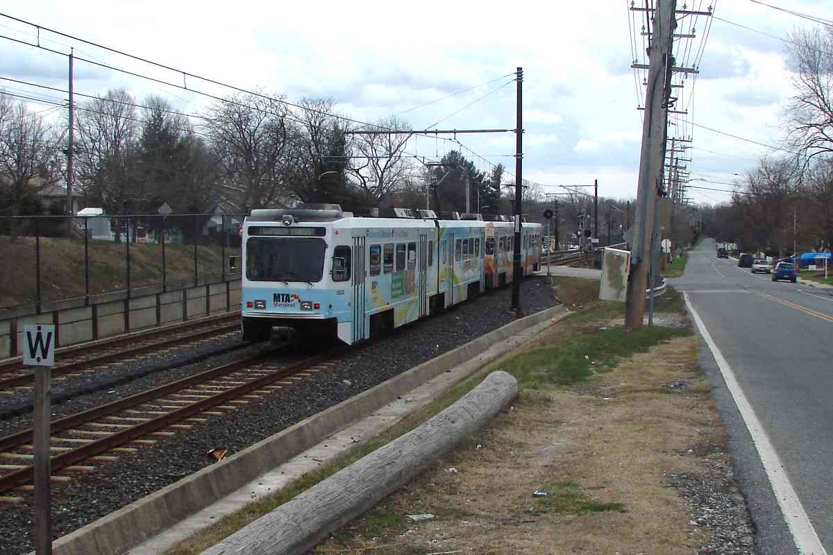
This sign near Light RailLink's Nursery Road stop memorializes a prior station: 
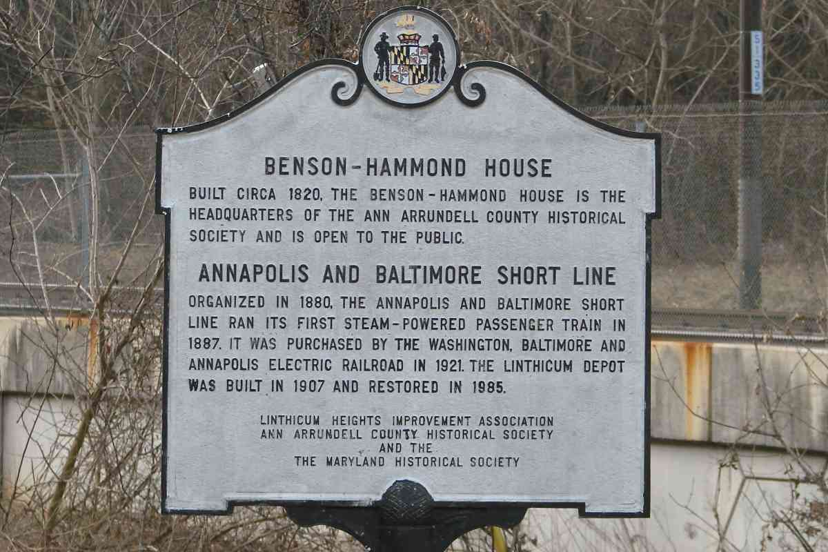
"Welcome to the Historic Pumphrey Community - Home of the original Pumphrey Railroad Station Baltimore & Annapolis Short Line March, 1887 - January, 1950. 1938 aerial

"This site is dedicated to the residents of Pumphrey by the Maryland Transit Administration on August 26, 2006.

"Robert L. Ehrlich, Jr., Governor - Michael S. Steele, Lt. Governor - Robert L. Flanagan, Secretary - Lisa L. Dickerson, MTA Administrator and CEO"

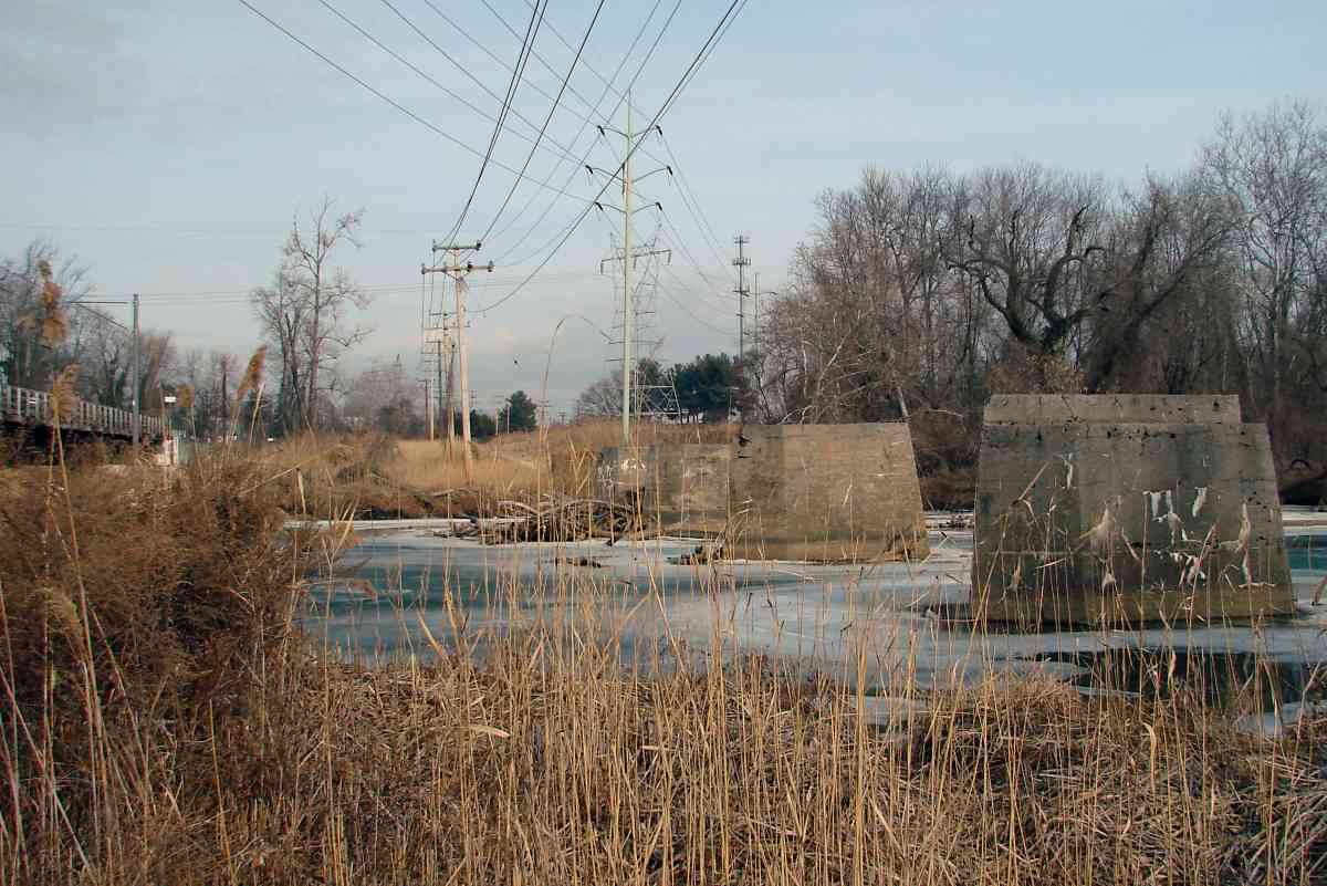
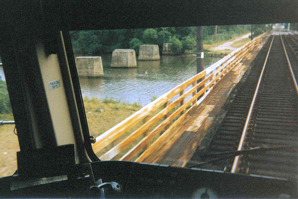
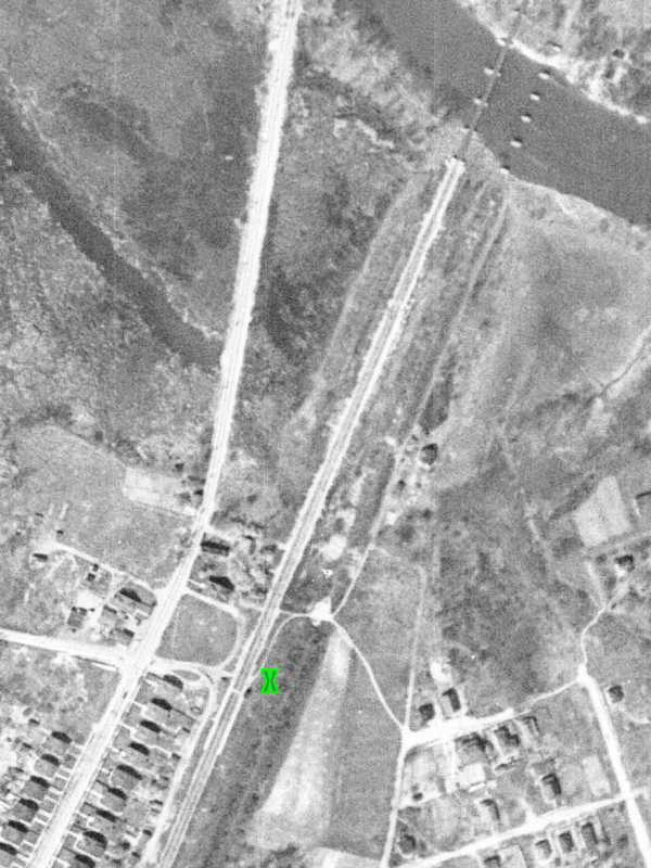
The green X marks the plaque's future location on a 1938 aerial. The plaque's text suggests ASL's Pumphrey Station endured to 1950, but there is no structure east (right) of the X where ASL's tracks had been. To the left of the X near the ex-WB&A tracks, there do appear to be one or two small waiting shacks that seem hardly worth memorializing.


Side-by-Side

Side-by-Side
Mile: 20.1 Date: Jan 2018
Ease: B+ View: N
Area: B- EH:
Map: AA 2 H 4 Topographic Maps

The utility poles on the right highlight the ASL route as it is about to exit Anne Arundel County.


Patapsco River

Patapsco River
Mile: 20.2 Date: Jan 2018
Ease: B+ View: NE
Area: B- EH: 79
Map: AA 2 H 4 Topographic Maps

Though ASL's bridge here was gone by 1938, more than 80 icy winters later its concrete supports soldier on hoping for a new purpose, perhaps part of a walking/biking trail to Southwest Area Park?


1927 Aerial
Photo courtesy Johns Hopkins University

1927 Aerial
Mile: Date: 1927
Ease: View: N (up)
Area: EH:
Map: Topographic Maps

After 1921 when the WB&A acquired ASL it relegated the line to freight and storage. The 1927 photo's resolution is too low to be certain but these appear to be empty coal hoppers. The hoppers may have been stationary for some time since they have been grouped so as to not block farm grade crossings.


From Light Rail

From Light Rail
Mile: 20.2 Date: Jul 1999
Ease: A View: S
Area: B- EH:
Map: Ba 42 H 12 Topographic Maps

During 1999, MTA car 5013 provided this viewing platform of the ASL's long-disused bridge remains.


Not Original
NEW! early-Dec 2021

Not Original
Mile: 20.6 Date: Jul 2021
Ease: B- View: E
Area: B- EH:
Map: Ba 42 J 11 Topographic Maps

In the vicinity of the I-695 Baltimore Beltway, ASL's right of way looks to have been repurposed as a utility access road. At a creek that runs parallel to the Beltway, I'd hoped to find an intact, original ASL bridge, but no such luck. Instead, this culvert has replaced the original; the large amount of fill above it means the access road sits at a higher elevation than had the railroad.


Ex-ASL

Ex-ASL
Mile: 21.0 Date: Oct 2017
Ease: A- View: NE
Area: B- EH:
Map: Ba 42 J 10 Topographic Maps

Pictured is MTA 5032 at the Baltimore Highlands stop that rests atop the ex-ASL right of way.

Link: B&A 50 in 1985


B&O 5079
Photo credit T.H. Arnold

B&O 5079
Mile: 21.4? Date: Nov 1935
Ease: View: S?
Area: EH:
Map: Ba 42 J 10? Topographic Maps

As if the distinguishing factors between ASL, WB&A, and B&A were not already sufficiently blurry, here's a B&O train operating on the ex-ASL, B&A tracks. B&O ran special trains to haul passengers between Baltimore and Army-Navy football games in Annapolis. Since this is a tour of the route established by ASL, regardless of which rail company operated upon it, this photo qualifies for inclusion.

Though the exact location is unknown, the power lines at left suggest somewhere between what are now the Baltimore Highlands and Patapsco light rail stops.


<< Previous (south) | THIS PAGE: Shipley to Baltimore Highlands | Next (north) >>

Or, return to main page

Copyright Notice