 |
Somerset &
Dorset Joint Railway Signalling at Bason Bridge |
 |
|||||
|
|||||||
The railway station at Bason Bridge was a simple intermediate station on the branch of the Somerset & Dorset Joint Railway (S&DJR) from Evercreech Junction to Highbridge in the county of Somerset. On 28-August-1854 the Somerset Central Railway (SCR) opened a single-track broad-gauge (7' 0¼") line from a junction with the Bristol & Exeter Railway (B&ER) at Highbridge to a terminus at Glastonbury and this was the first section of the future S&DJR. The station at Bason Bridge was opened later in 1856, probably about the same time as the next station down the line at Edington Road (later Edington Junction).
In 1862 the SCR merged with the Dorset Central Railway (DCR) to form the Somerset and Dorset Railway (S&DR) and in 1863 opened a continuous line to Wimborne. The DCR was constructed as standard gauge (4' 8½") and so the existing SCR system becoming mixed gauge, but in due course the broad gauge fell into disuse and was removed from the S&DR system about 1870. In 1874 the S&DR opened a line from Evercreech Junction to Bath and in 1875 it became the S&DJR when the line was leased jointly by the Midland Railway (MR) and London & South Western Railway (L&SWR). After the Grouping of the railways of Great Britain in 1923 the S&DJR remained a Joint line, but now under the control of the London, Midland & Scottish Railway (LMS) and the Southern Railway (SR), who were the successors to the MR and L&SWR respectively. The railways were nationalised in 1948 and in 1950 the Joint line west and north of Evercreech Junction came under the control of British Railways (Western Region) (BR(WR)). The S&DJR closed to passenger traffic on 6-March-1966, but some milk traffic survived at Bason Bridge until 1972.
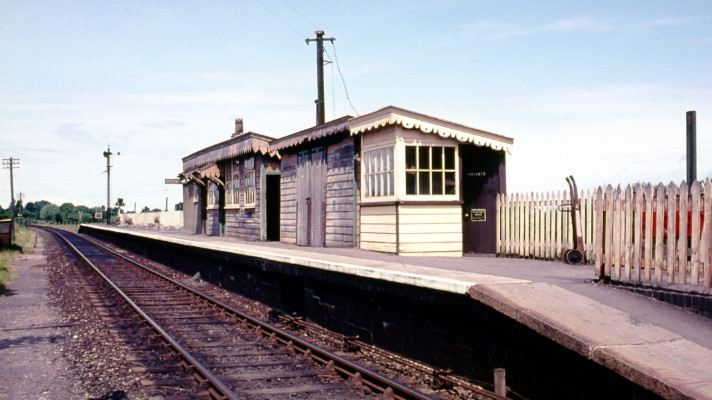
Bason Bridge station looking west in British Railways days circa-1965
| Brief History of the Station and Sidings |
The village of Bason Bridge lies about 2½ miles to the east of Highbridge on the north side of the River Brue, where the current B3141 road (Church Road) crosses the river to reach East Huntspill on the south side. In this area the SCR line ran along the north bank of the river roughly on a west-to-east alignment and crossed the road by means of a level-crossing. Very little is known about the original station, but it would appear to have changed very little over the years, being just a single platform on the north (Down) side of the line immediately to the west (Highbridge side) of the level-crossing at 20 miles 54 chains from Evercreech Junction. Some simple wooden buildings on the platform provided all the basic passenger facilities and no sidings were provided until the early 1900s. Despite its humble appearance, by the late-1920s the station had a staff of six:- the Stationmaster, two Clerks, two Porter/Shunters and a Junior Porter.
[Note: Atthill [1] states that the (original?) station had a row of low buildings on the UP side, but that may be a mis-print and/or a mis-interpretation of the details on early Ordnance Survey maps.]
S&DJR Officers' Minute 6325 of 25-July-1910 recorded that there were no 'sanitary conveniences' at Bason Bridge, so it was agreed to provide "...a small ladies' waiting room, together with a urinal and W.C..." {the latter presumably being intended for gentlemen!} at an estimated cost of £99. The work was to be done "...in connection with the renewal of the station platform...", but no details are known about that renewal, and it would include a connection to the public water main in order to provide water to both the station and the Stationmaster's house. It would appear therefore that the original provision of buildings on the station platform was not as extensive as seen in later photographs. By 1921 there was also a small pent-roof hut on the south side of the line immediately next to the west side of the level-crossing, but its date of construction and purpose are not known (contrary to the claim of some commentators, it was not the hut for the station ground-frame); however the annotation 'S.M.O.' on a railway survey plan would suggest that it might have served as the Station Master's Office.
A house for the Stationmaster had been built (at an unknown date by the 1880s) on the land between the railway and the river-bank, directly opposite the platform. The S&DJR Officers' Minute 5302 of 21-January-1902 recorded that the house stood on a 'bad foundation' and was in an unsatisfactory condition, despite every effort to keep the house habitable, so it was decided that re-erection on a new site was now 'absolutely necessary' and a plan was approved at an estimated cost of £355. It is not known exactly when that work was done, but in due course a new house was built some distance further westwards towards Highbridge, but again on land between the railway and the river-bank; it would appear that the old house was demolished soon afterwards.
By the time of the 1905 Appendix to the S&DJR Working Timetable (WTT) the station was listed as a telegraph post (code 'LM') on telegraph circuit No 6 (the Evercreech Junction North signal-box to Highbridge Loco signal box and station local circuit, which included the Bridgwater Branch). It was open from 6:40am until the last passenger train on week-days, but there was no Sunday duty. However by the time of the 1914 WTT Appendix the telegraph post was open on Sundays for the passage of the Down milk train (as by that date the milk factory siding was in operation).
The 1905 WTT Appendix (click here) also gave details of the bell-codes to be used by the signalman at Highbridge Loco signal-box to warn Bason Bridge of the approach of trains from Highbridge or Edington Junction. That information appeared also in the 1914 WTT Appendix, but it was not included in the 1933 WTT Appendix; it is unclear if its absence from the latter was because the warnings were no longer needed for some reason, or perhaps the details were now recorded elsewhere. It is not known whether the bell at Bason Bridge was located in the station ground-frame hut or perhaps the Booking Office or Stationmaster's Office. |
|
|||||||||||||
At the S&DJR Officers Meeting of 20-April-1909 it was reported (Minute 6210) that Wilts United Dairies Ltd proposed to erect a large milk factory at Bason Bridge and requested the S&DJR to provide them with a siding "...which would also be available for general goods traffic". At the subsequent meeting on 26th July it was agreed (Minute 6227) that a siding could be built at an estimated cost of £913 on land that would be conveyed free of cost to the Railway by the Dairies Company. This land would include provision "...for forming, when necessary, the goods wharf for the use of the general public...", although the Minute also records a decision that such a provision was not justified at that time. In due course the factory was built on land on the north side of the railway immediately to the east (Glastonbury side) of Church Road and a siding provided between it and the railway on the Down (north) side of the line. During the following decades there were various minor expansions in the factory's facilites and there are occasional references to these in the Minutes of the S&DJR Officers meetings with requests from the Dairies Company for various additional facilities.
It is unfortunate that very little map evidence has come to light for the several decades when the sidings were in use. The 25-inch series of Ordnance Survey maps appears to have no coverage between a survey done in 1902 (prior to the provision of any sidings) and an edition published in 1970 (after cessation of all public services) by which time some sidings had been removed. At some date two parallel dead-end sidings were constructed immediately to the east of the level-crossing on the Down side of the line, accessed by an extension of the trap-road at the west end of the Down Siding; these appear on a 1921 Midland Railway survey, which formed the basis for the plan included in the Judge & Potts book [2] and Cooke's track diagram [3]. A cattle-dock was provided on the north side of the siding nearer to the single-line at the buffer-stop end, while the other siding (further from the single-line and terminating against the east end of the cattle-dock) had a short kick-back siding leading into the milk factory. It is believed that these two sidings were provided for public goods traffic, although the milk factory may have shared use of them also.
It is unclear if both sidings were provided at the same time, as there is some evidence to suggest that the siding nearer to the main line may have existed in 1910, so perhaps the siding further from the main line was a later addition. Certainly there were various alterations as the milk factory continued to expand, although the precise nature and extent of the various changes is unclear. Minutes 6802 and 6839 for the S&DJR Officers meetings of 20th April and 18th October respectively in 1915 both record a request from the Dairies Company to expand their facilities by using a portion of railway land, in exchange for which they would hand over a strip of their own land "...on the north side of the goods yard". Minute 7031 (S&DJR Officers meeting of 11-July-1918) records approval (subject to various conditions) of a further application for "...additional siding accommodation...". At some time by 1938 another short siding, connected at both ends, had been added on the north side of the original Down Siding, which may have been the subject of a revised Private Siding Agreement enacted in 1934. In 1938 a new Up Siding was added on south side of the main single-line; initially this was connected at the east end only, but a connection at the west end was added in 1939. (For more details about the sidings see the signalling information below.)
By the time of the 1933 Appendix to the Working Timetable (WTT) the following 'Local Instructions' were included for Bason Bridge:-
| Signalling Information | ||||
|
Very little is known about the early signalling arrangements on the SCR (click here for more details about early S&DJR signalling.) However by the early 1900s the signalling installation at Bason Bridge had developed into a form that, apart from some alterations in the 1930s, lasted relatively unchanged until the end of the passenger service in March 1966. For descriptive purposes the signalling can be divided into two parts, conveniently divided by the level-crossing and each controlled by its own ground-frame (GF). The GF at the station itself was known simply as Bason Bridge GF, whilst the GF at the sidings was known as Bason Bridge Siding GF.
[Note: some commentators refer to the GF at the station variously as the 'station' or 'crossing' GF. Most official records appear not to apply any suffix to its name, but one S&DJR drawing does use the 'station' designation; where necessary for clarification the two GFs will be referenced in RailWest as the 'station' and 'siding' GFs.]
The National Archives (TNA) file MT6/11/91 contains a copy of B&ER "Instructions to Head Guards and all others concerned in the working of the single line between Glastonbury and Highbridge" dated 16-September-1854. The gist of these instructions was that no train was to move over the line without the guard (who was nominated specifically on a daily basis) on board, the implications being that at that time the whole branch from Highbridge to Glastonbury was worked as a single block section with a form of 'Pilot Guard' working (click here to see the full text). Clearly these arrangements would have been supersed once the SCR had extended eastwards beyond Glastonbury and certainly it would appear that by 1874 the line was being worked purely by 'block telegraph' without any form of physical 'train staff' in common with the rest of the S&DJR.
As described here, under the S&DJR's original 'block telegraph' method it was quite simple to provide block instruments at intermediate locations which could be switched 'in' or 'out' as required. It would appear that Bason Bridge had been provided with block instruments at some date, as S&DJR Officers Minute 377 of 8-November-1876 records for Bason Bridge that "...block instruments to be removed and block made through between Highbridge and Edington...". Then in 1886 S&DJR Officers Minute 3390 of 23rd September records that conversion to Train Staff & Ticket (TS&T) working had been completed on the branch from Evercreech Junction to Highbridge on 13th September (details are listed in WTT Appendix 8 dated 1-October-1886), at which time Bason Bridge became an intermediate location within the Shapwick - Highbridge Loco block section. Subsequently that block section was divided into two new separate sections (both with TS&T working) when a new signal-box was opened at Edington Junction in July 1890, after which Bason Bridge was within the new Edington Junction - Highbridge Loco section.
At an S&DJR Officers meeting on 27-October-1892 (Minute 4138) it was decided to install Electric Train Tablet (ETT) working on the Edington Junction - Highbridge Loco section and an undertaking for this was given to the Board of Trade (BoT) on 28-January-1893, but the actual date of introduction is unknown. (This work was done by re-using the Tyer's No 1 instruments recovered from the former single-line section between Binegar and Shepton Mallet after that stretch of line was doubled on 28-November-1892.) At some unknown date between 1933 and 1938 the Tyer's No 1 instruments were replaced by the Tyer's No 6 pattern, possibly as a result of the increase in facilities at the milk depot at Bason Bridge and/or the need for trains to be able to 'trip' from Highbridge and return. In BR days the ETT equipment was replaced by the BR(WR) pattern of Electric Key Token working probably circa-1952/53 and then in 1956 the block section became Shapwick - Highbridge East 'C' (formerly Highbridge Loco box) after the closure of the signal-box at Edington Junction on 4th February that year. However none of those changes in the method of block working would have had any significant effect on operations at Bason Bridge once it had ceased to be a block-post in 1876, other than the changes between the different types of tablet and key token would have required the release lock for the 'sidings' GF to be modified accordingly.
The S&DJR ran milk trains every day, including Sundays, which took the milk traffic to Templecombe for onward transport by the Southern Railway. To avoid the need to open several signal-boxes on Sundays just for the passage of one train, and its return journey some hours later, special operating arrangements were put in place. During the 1930s these were issued as part of a 'Programme of Special Trains and Special Instructions' - click here for an excerpt from Season Programme No 1 for 1938. On the Highbridge Branch, prior to the closure of Highbridge Loco signal-box on a Saturday night (or early Sunday morning), the signalman there would withdraw a tablet for the single-line section to Edington Junction and leave it secure in the box. Normal ETT block working between Highbridge Loco and Evercreech Junction North boxes would be suspended and replaced by Pilotman working. The Pilotman would collect the tablet (which was needed to unlock the 'sidings' GF at Bason Bridge) and then travel on the milk train all the way to Evercreech Junction (and indeed onwards to Templecombe); along the way he would operate signal-boxes or level-crossing gates and authorise the driver to pass signals at 'danger' as required. When the train returned to Highbridge the Pilotman would secure the tablet back in the Loco box. On the Monday morning the signalman at Highbridge Loco would advise Evercreech Junction North that the milk train had returned clear of the Branch, after which normal ETT block working would be resumed.
Note: in the Season Programme No 1 for 1933, on each Monday morning the signalman at Highbridge Loco was instructed to use the tablet returned from the milk train for the first train of the day from Highbridge to Edington Junction. However by the time of the Season Programme No 1 for 1938 the signalman was instructed simply to 'cancel' the tablet (ie replace it in the ETT instrument). This difference confirms that in 1933 the ETT instrument was still the old 'non-returnable' Tyer's No 1 pattern, whereas clearly by 1938 it had been replaced by the 'returnable' Tyer's No 6 pattern.
The earliest known mention of any signals at Bason Bridge can be found in S&DJR Officers Minute 377 of 8-November-1876, which recorded that "Distant signals are to be provided in each direction at Bason Bridge" (by that date semaphore signals were being provided instead of disc-and-crossbar (D&C) signals); however it is not known how those signals were to be worked. (Note: the Minutes for that meeting make various references to the provision or replacement of Home signals at some of the other level-crossings on the line, but there is no such mention for Bason Bridge. It is unclear therefore whether Bason Bridge already had Home signals or they were added at a later date.) The 1886 Ordnance Survey map marks a single signal-post on the Down side of the line between the level-crossing and the end of the platform and one may speculate whether perhaps that may have been a D&C signal or a post with two opposing semaphore arms (click here for more details about signalling at S&DJR level-crossings); certainly there was still a D&C signal at Huntspill crossing (the next level-crossing down the line towards Edington Junction) that was not abolished until 1889.
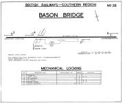 At some unknown date the signalling was upgraded to provide Distant and Home signals in both
directions, worked from an interlocked GF housed in a small
pent-roof hut on the platform at the east end of the existing buildings (20m 52c
from Evercreech Junction). The precise type of
lever-frame is unknown, but in later years it was recorded as being a 'low
frame' with levers at 5-inch centres (which might suggest
a frame of Saxby & Farmer design, but that can not be proven). The GF had six
levers working the four signals, a bolt on the level-crossing road gates and a
bolt for the pedestrian wicket gates; electric arm repeaters were provided for the two Distant signals. Given that the installation appears to
have remained virtually unchanged throughout its existence, it is probable that the original installation varied very little (if at all) from the final
arrangements in BR days shown here (click diagram for larger image or click
here to see the
'dog chart' for the mechanical locking). As late as the 1960s an S&DJR oval
lineman's board still hung on the front of the
GF hut.
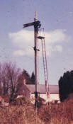 The
Down Distant (click picture for larger image) was located on the
right-hand side of the line and had a lower-quadrant (LQ) arm on a lattice post,
unusually with what would appear to be an Evans O'Donnell 'arrow-head' type
finial. The Down Home signal
was also a LQ arm on a lattice post and both Down signals had white 'sighting
boards' fixed down the front of their posts in order to improve visibility of
the signal for approaching drivers. (Although all official signal diagrams and early maps
show the Down Home signal a short distance west of the Highbridge
end of the platform, all known photographs show it actually on the
platform.) A 1930s photograph shows the Up Home to have been a tall-ish post (about the same
height as the Down Home) with a LQ arm and it is probable that it
too was a lattice post with a sighting board. By BR days this
signal had been replaced by a shorter SR-type rail-built post with an
upper-quadrant arm; S&DJR Signal Instruction
(SI) 370 states the Up Home arm was lowered 10' on its post on 30-June-1938, but
it is unclear if that change coincided with the change in style of arm+post. No photographs are known of the Up Distant, which was
sited on the Up side of the line about mid-way between the Up Home and
Bridge 276 over the River Brue (roughly opposite Moor Row farm on the other
side of the river).
As described above, in 1909 a siding was constructed to serve the new milk factory. According to TNA file MT6/1884/3 the S&DJR reported to the BoT on 25-November-1909 that the siding was ready for inspection and the subsequent BoT Inspection Report was dated 24-January-1910. The new siding was located east of the level-crossing on the Down (north) side of the line and it was connected into the single-line by points at each end. The point in the single-line at the Highbridge end faced Down trains and that at the Glastonbury end faced Up trains; a diagram from that period shows that there were trap points at each end of the siding which lead to short dead-end spurs. Control of all the points and their associated Facing Point Locks (FPL) was by a new 4-lever Bason Bridge Siding GF installed on the Down side of the line roughly mid-way between the two sets of facing points. (It is not known if this new GF was housed in any sort of hut, but that is a possibility.) The new GF was located 650' east of the 'station' GF (at approximately 20m 42c from Evercreech Junction) and it was unlocked by the single-line tablet for the Edington Jcn - Highbridge Loco section; the east and west points were 210' and 280' respectively from the GF.
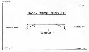 For such a
simple installation, there were a number of curious features evident from
the relevant official diagram (sadly too big to reproduce here, but
click the image for a larger sketch):-
In 1910 there was a proposal to add an extra lever (No 5) to the 'sidings' GF to work 'slots' on the Up Distant and Up Home signals controlled by the 'station' GF. (A 'slotted' signal was one which was controlled by two separate signal-boxes and/or GFs and would only move to 'off' when both the controlling levers were pulled.) It would appear that this change was implented in due course, as the details appear in a 1930 copy of the signal diagram for the 'sidings' GF and the abolition of those controls is mentioned specifically in SI 364 in 1938. It is unclear however why such a change was made here; there could be only one train at any one time in the single-line block section, so the alteration would seem to offer little or no extra protection for a train shunting the sidings especially as no equivalent 'slots' were provided on the Down signals.
When the 'sidings' GF was locked (not in use for shunting purposes) lever 5 had to be left in the reverse position so that its 'slots' on the Up signals would be 'off', so that the 'station' GF could work its signals as normal; this meant that when the GF was locked levers 1, 3 and 5 were all reversed and only 2 and 4 were normal. When the GF was unlocked lever 5 had to be put back to normal first, thereby ensuring that the Up signals could not be cleared while the sidings were in use. It would appear also from the 1930 diagram that the locking was altered so that the FPLs locked the points in their 'normal' position only; although that would be the usual arrangement for the facing points in a single-line leading into sidings, curiously it meant also that the trap-points at the siding exits were bolted only when the siding was 'closed' and therefore no shunting movements were taking place out of the siding anyway.
During the 1930s various alterations were made at the sidings. Some commentators have described these changes in a way which implies that they all occurred concurrently, but in fact the available records show that the work was spread over a number of years and did not conclude until 1939. According to SI 337 the points at the east end of the siding were moved 99 yards further east (away from the GF) on 28-May-1933 and then on 11-June 1933 the points at the west end were moved 31 yards east (towards the GF), so the net result was to lengthen the siding loop by 68 yards. The points at the east end were moved eastwards again on 15-Aug-1937 (SI 360), lengthening the loop by a further 78 yards. Then on 20-February-1938 (SI 364) the existing 'sidings' GF was abolished and replaced by a new GF located 'about 116 yards' further away from the station, which Cooke [3] records at 20m 37c; at the same time the 'slots' on the 'station' GF's Up Distant and Up Home signals were abolished.
The new GF had a frame of 13 levers (almost certainly of the standard SR 'knee' type) located back-to-track in a typical SR pent-roof ground-level wooden hut located on the Up (south) side of the single-line. Two months later a new Up Siding was opened on the south side of the single-line (between the railway and the river-bank) on 13-April-1938 (SI 367), which was accessed by a point facing to Up trains and sited a few yards to the east of the new GF; two new 'dwarf shunting signals' were provided to control movements into and out of this new siding. In the following year the Up Siding became a 'loop' siding on 3-February-1939 (SI 377) when its west end was connected into the single-line by a new point facing to Down trains; here again two new 'dwarf shunting signals' were provided to control movements into and out that end of the siding. Although the official diagram for the 1938 installation shows all the 'dwarf shunting signals' as the 'miniature semaphore' type, the only known photographs of those ground signals are from the BR period and show the later 'half-disc' type, so it is not known exactly which type were installed originally.
| Details for new Bason Bridge Siding GF from 1938 onwards | ||
| Click any thumbnail to see larger image | ||
| GF Diagram circa-1950 | Dog Chart circa-1937 | |
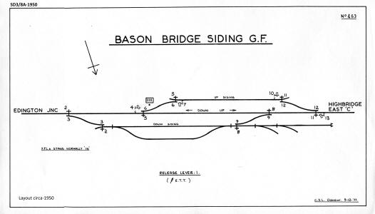 |
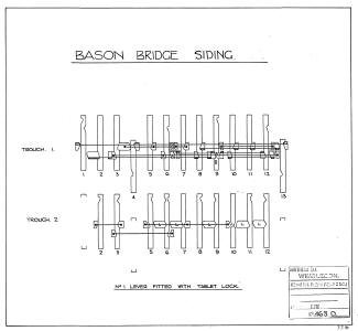 |
|
| Mechanical Locking Table 1939 | ||

|
||
On 8-July-1937 the SR raised an order for a set of 13 Lever Description Plates for the new Siding GF; these plates would have been in the contemporary SR style of oval cast-iron plates with painted legends. The order included plates with the appropriate descriptions for levers Nos 10-13; it is unclear therefore what was done with those plates during the period between the installation of the GF in February 1938 and the installation of the equipment worked by those levers in February 1939, but it is assumed that all 13 levers were installed in the frame at the outset in 1938.
Bason Bridge was closed to public goods traffic on 10-June-1963. Passenger traffic ceased on 6-March-1966 along with the rest of the S&DJR, at which time the line eastwards from 20m 28c (just east of the milk factory sidings) to Evercreech Junction was closed completely. However the remaining section of line westwards to Highbridge continued to be used for the milk traffic, which had always been an important daily feature of S&DJR operations. On the same date both GFs were taken out of use, all signals were abolished, all the points converted to hand-lever operation, and the level-crossing gates were padlocked across the road and operated by the train-crew as required (BR(WR) Weekly Notice K2/9/66). Thereafter the line from Highbridge to Bason Bridge was operated simply as a long siding under the control of the signalman at Highbridge with a permanent speed restriction of 10 MPH (as listed in Table C2 of the September 1969 BR(WR) Sectional Appendix for the West of England Division).

Extract from Chief Civil Engineer's line diagram post-1966
After closure to passenger services the various buildings on and around the platform were demolished and by the time of a 1970 OS map the track eastwards to Glastonbury had been lifted, as also had the two public goods sidings. Milk traffic finally ceased on 3-October-1972, after which the line from Highbridge was lifted and the level-crossing was abolished. The milk factory itself closed eventually in 1987, since when the site has been been used for other business purposes and has absorbed the former sidings area; the view eastwards from the road is now blocked by a row of tall trees. The 'new' stationmaster's house survived as a private residence for many years until sadly it was destroyed by fire on 10-April-2020. Only the actual station platform now remains visible in the undergrowth as the sole substantial remnant of the railway's presence in Bason Bridge. However the hut from the 1938 'sidings' GF passed into private hands and has been restored elsewhere by its current owner.
© CJL Osment 2021-24
Acknowledgements to Tony Cooke and Peter Russell for additional information.
Station colour photograph courtesy Mike Morant collection,
Down Distant photograph © Chris Newman.
References