TrainWeb.org Facebook Page
WB&A Photo Tour


Washington, Baltimore and Annapolis Railway
Modern day photo tour

Accompanying each photo below are:

Click a photo to see a larger view. Please send your comments and corrections to Steve.


<< Previous (southwest) | THIS PAGE: Patuxent River to BWI Airport | Next (northeast) >>

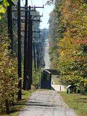
Pole Line

Pole Line
Mile: Date: Oct 2017
Ease: A View: S
Area: A EH: 84
Map: AA 17 E 1 Topographic Maps

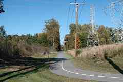
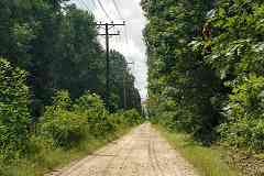
This view looks a mile back toward the Patuxent River from the Anne Arundel County side. Though WB&A's alignment is obviously marked by the utility poles, confusion over of who presently owns the old right of way has delayed construction of the WB&A Trail here. Apparently the county owns the land on the northwest side of WB&A (right) but for unclear reasons has refrained from extending the trail through it.

Link: Buz Meyer and the trail


Two Rivers

Two Rivers
Mile: Date: Oct 2017
Ease: A View: N
Area: A EH: 91
Map: AA 17 E 1 Topographic Maps

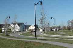
Turning to look the opposite direction from the same spot reveals large tracts of land have been available to facilitate construction of the Two Rivers community. Off photo left, gravel pits that date to the early days of WB&A have been repurposed into retaining ponds. Stone was mined here for WB&A track ballast, and later for other uses into the 2010s.

Prior to the paving of Two Rivers Boulevard during 2013, the utility wires had continued away from the camera toward the gap in the trees at distant right. WB&A had a stop a short distance north of where Two Rivers Boulevard meets realigned Conway Road but no evidence of it remains.


From Conway Road
Photo courtesy Google

From Conway Road
Mile: Date: Jun 2008
Ease: A View: S
Area: A EH:
Map: AA 17 E 1 Topographic Maps

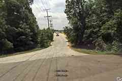
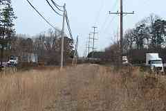
This was the scene from where WB&A and Conway Road had intersected before Two Rivers arrived and shifted Conway Road south to about where that gravel truck is. As the pavement's grading hints, previously Conway Road had bridged over the WB&A. To the north in 2008 the WB&A Trail had not yet officially arrived, and was little more then a weedy path under utility lines.


Trail Resumes

Trail Resumes
Mile: Date: Oct 2017
Ease: A- View: N
Area: A EH:
Map: AA 12 E 13 Topographic Maps

Now we're closer to the aforementioned gap in the trees. Both the trail that had ended at the Patuxent River and the utility poles resume following the WB&A's alignment here. Why does the trail curve in from the right (east)?


Dining Room

Dining Room
Mile: Date: Oct 2017
Ease: A- View: S
Area: A EH:
Map: AA 12 E 13 Topographic Maps

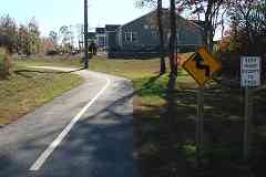
The trail makes a big, S-shaped, incomplete detour at the Two Rivers development not only because of the previously mentioned property dispute but also because now someone's dining room is in the way.

This home and the others adjacent have the distinction of being the only private residences anywhere sitting atop what had been the WB&A line. Rails to nails?


Braegers Road

Braegers Road
Mile: Date: Aug 2000
Ease: B View: S
Area: A- EH:
Map: AA 12 F 12 Topographic Maps

After rail service ended during 1935, much of the right of way between Bowie and Odenton was repurposed into Braegers Road, which remained unpaved until about 2009. I have also seen the name spelled Bragers; it may have originally been applied to what is now named Patuxent Road.


From Patuxent Road
Photos credit James P. Shuman

From Patuxent Road
Mile: Date: Jul 1935
Ease: A View: S
Area: A- EH: 107
Map: AA 12 F 11 Topographic Maps

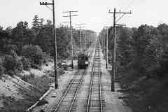
zoom As straight as the arrow in its herald, WB&A track permitted high speeds between stops. The white placard on the car likely advises customers of the WB&A's impending shutdown.

This view was snapped from the Patuxent Road bridge over the tracks. Through the summer haze note the similar grade separation back at Conway Road.


Braeger Station
Photo credit James P. Shuman

Braeger Station
Mile: Date: Jul 1935
Ease: A View: NE
Area: A- EH: 84
Map: AA 12 F 11 Topographic Maps

Bits of Braeger Station, basically a waiting shack, can be glimsped at bottom left. The structure sat at the northwest corner of what is currently the WB&A Trail at Patuxent Road. Braeger Siding peels off to the right to Alan Barton Company, and farther down Little Patuxent Siding peels off to the left, both to gravel pits that are now filled by water. Much of the gravel had been washed down from upstream by floods.


Little Patuxent

Little Patuxent
Mile: Date: Oct 2017
Ease: B View: NE
Area: A- EH:
Map: AA 12 F 10 Topographic Maps

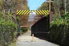
WB&A's bridge across the Little Patxuent was likely one of those sold for scrap during the difficult economic times of the 1930s. The trail waited until 2008 to receive this replacement.

Since the sign reads, "No Jumping, Diving, Swinging From Bridge" that means anything else goes, right?


Bridge Artifact

Bridge Artifact
Mile: Date: Oct 2017
Ease: B View: NE
Area: A- EH:
Map: AA 12 F 10 Topographic Maps

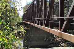
attachments The trail's bridge reuses WB&A abutments at either end, but arcs over the mid-river supports where after 80 years one can still find bridge attachment hardware.

Between roads, houses, trails, and, as we'll see later, airports and light rail, very little of WB&A's route has remained in an untouched state likely to yield artifacts.


Hills

Hills
Mile: Date: Oct 2017
Ease: B+ View: S
Area: A- EH: 107
Map: AA 12 G 9 Topographic Maps

Hills like these revealed by deep zoom back 1.5 miles were not a problem for the electrically-powered trains that could match the speed of the era's steam locomotives. Instead, the frequent stops made by WB&A slowed travel: the trip between Baltimore and Washington took less time on B&O.


Creek

Creek
Mile: Date: Oct 2017
Ease: B+ View: N
Area: A- EH:
Map: AA 12 G 9 Topographic Maps

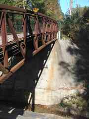
Though WB&A's bridge here remained walkable into the 2000s, for the trail it was replaced in favor of this model. It appears a fresh mound of concrete was poured down over the old abutments.


Strawberry Lake Way

Strawberry Lake Way
Mile: Date: Oct 2017
Ease: A View: N
Area: A EH:
Map: AA 12 G 9 Topographic Maps

When Strawberry Lake Way arrived around 2000, it created a new grade crossing.


Egg Arch

Egg Arch
Mile: Date: Jan 2021
Ease: B View: W
Area: A EH:
Map: AA 12 G 9 Topographic Maps

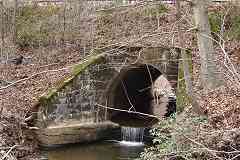
An alert reader called my attention to a bridge I had missed. This one over an unnamed creek exhibits an atypical-for-WB&A, egg-shaped arch.


Knotty Pole

Knotty Pole
Mile: Date: Jan 2021
Ease: A- View: N
Area: A EH:
Map: AA 12 G 9 Topographic Maps

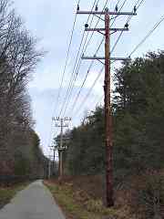
Utility lines still follow most of WB&A's former route, most supported by standard poles. This pole, however, has unusually knotty wood. A recheck of old photos reveals knotty poles like this had been much more common when WB&A trains were operating.

The last WB&A train ran here during 1935. Might this pole be a survivor from then? Possibly. In this region, the average life of utility poles is about 50 years, but some are known to endure for over 100 years. They are inspected regularly and replaced only when needed.


Old Waugh Chapel Road

Old Waugh Chapel Road
Mile: Date: Oct 2017
Ease: B+ View: NE
Area: A- EH:
Map: AA 12 H 6 Topographic Maps

I was hoping to find an older structure supporting Old Waugh Chapel Road. This location was a WB&A stop.

With the original railway defunct since 1935, scant are WB&A artifacts and Web info. This tour may be the most concentrated record of the WB&A currently online.


Piney Orchard Parkway

Piney Orchard Parkway
Mile: Date: Oct 2017
Ease: A View: NE
Area: A- EH: 159
Map: AA 12 J 3 Topographic Maps

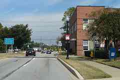
The nearest black car has just rolled over where WB&A's main line and South Shore division, the former Annapolis & Elk Ridge (A&ER) Railroad, had met at diamond track. At Naval Academy Junction, offices as the spot was known, passengers bound for or from Annapolis would change for trains to Baltimore and Washington. Their platform was on the right near the USPS mail collection box. The brick building beyond is a remodeled WB&A office. Some of these rails have forging dates in the 1920s.

The location was called Naval Academy Junction because the US Naval Academy in Annapolis was one of the primary stops along the South Shore division. Midshipmen and others would change to/from main line trains here.

Links: older pics, building's tenant


Naval Academy Junction
Photo credit James P. Shuman

Naval Academy Junction
Mile: Date: May 1935
Ease: A View: S
Area: A- EH: 150, 157
Map: AA 12 J 3 Topographic Maps

That's the WB&A office building at left prior to remodeling, and beyond it the passenger platform.

On the right, a WB&A bus pauses for transfers to Fort Meade which is a few miles to the east (right).

Change for: A&ER line to Annapolis


Odenton Map
Photo courtesy Johns Hopkins University

Odenton Map
Mile: Date: 1952
Ease: View: N (up)
Area: EH: 154
Map: AA 12 Topographic Maps

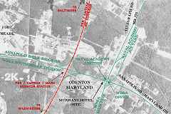
A&ER arrived first (1840), but it was not until 1872 when B&P (later Pennsylvania) Railroad intersected that the town of Odenton formed. Another 32 years elapsed before WB&A joined the railroad scene.

WB&A's operations through Odenton had ceased by the time of this 1952 aerial photo, with part of its right-of-way expropriated by Telegraph Road (Maryland 170), and other parts reorganized into Baltimore and Annapolis Railroad. This aerial photo predates Maryland 32.

Crosshatched lines show where rails remained extant as of 2017. The stretch between Odenton Station and Naval Academy Junction was used at least as recently as 2013.


1961 Aerial
Photo credit unknown

1961 Aerial
Mile: Date: 1961
Ease: View: N
Area: EH: 152, 154
Map: AA 12 K 3 Topographic Maps

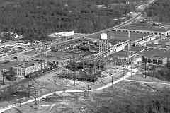
Northeast of Naval Academy Junction was Naval Academy Junction Yard, WB&A's primary car maintenance facility, not to be confused with "The Yard" as midshipmen refer to the Naval Academy campus some 10 miles away in Annapolis.

WB&A's old yardw as repurposed during 1941 by the National Plastics Products Company which endured until 1961 when, per the boxcars in this photo, rail service was still active. The site changed owners several times and saw its last industrial use by Nevamar Company during the early 2000s.


Substation

Substation
Mile: Date: Oct 2017
Ease: A- View: SW
Area: A- EH: 177
Map: AA 12 K 2 Topographic Maps

Both in 1961 and today, electrical substations dot the route, the most tangible evidence of WB&A's former presence. When this yard substation was last used by WB&A, it stepped down the supply from 33000 volts to the 1200 volts employed by the rolling stock.

Links: pics of WB&A rolling stock, more (as B&A)


Apartments

Apartments
Mile: Date: Oct 2017
Ease: A- View: NE
Area: A- EH:
Map: AA 12 K 2 Topographic Maps

The old factory buildings were demolished during 2013 to make room for new apartments on a portion of the land. In the foreground, rails remain embedded in concrete.

Link: Flats170 history


Tear Down
Photo credit R.K. Henry

Tear Down
Mile: Date: Oct 1936
Ease: A View: NE
Area: A- EH:
Map: AA 12 J 3 Topographic Maps

Steel rails have scrap value, wood crossties not so much. These ties might still be buried under the pavement of Maryland 170.


Separating

Separating
Mile: Date: Oct 2017
Ease: A View: N
Area: A- EH:
Map: AA 12 K 2 Topographic Maps

Maryland 170 and WB&A go their separate ways northeast of Odenton.


Power Lines

Power Lines
Mile: Date: Mar 2019
Ease: A- View: N
Area: A- EH:
Map: AA 12 K 1 Topographic Maps

Power lines still clearly delineate the WB&A alignment north of Odenton. Near photo center, a truck illustrates the location of MD 32. On this side of MD 32, a WB&A bridge that spanned a small creek had survived into the 1980s; now the streambed there is littered with pieces of concrete and rusty metal. Prior to MD 32, on the right had stood the Super 170 Drive-In theater that opened during 1963.

Link: Super 170 at Cinema Treasures


Severn Run

Severn Run
Mile: Date: Feb 2005
Ease: B- View: W
Area: A EH:
Map: AA 6 K 13 Topographic Maps

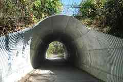
On the north side of Maryland 32 is found the only remaining stretch of accessible, undisturbed WB&A Main Line right of way. A mere 500 feet in length, it still manages to contain three significant WB&A artifacts, one of which is this double quasi-arch masonry bridge across Severn Run, the largest surviving WB&A masonry bridge. A similar but smaller bridge has been reviewed by the Maryland Historical Trust.


Old Mill Road

Old Mill Road
Mile: Date: Feb 2005
Ease: A View: NW
Area: A EH:
Map: AA 6 K 13 Topographic Maps

Just north of Severn Run are disused bridge abutments at Old Mill Road.

Old Mill may refer to Collings Fulling Mill on Severn Run that dates to the 1770s, or to an even older mill in the area named Summerland Mill.


Severn Run Station

Severn Run Station
Mile: Date: Feb 2005
Ease: A View: N
Area: A EH:
Map: AA 6 K 13 Topographic Maps

And just a little farther north one finds this concrete, likely the foundation of WB&A's Severn Run Station. It is the most complete of the station foundations I have found along the main line.


Clark Station Road

Clark Station Road
Mile: Date: Oct 2017
Ease: A View: N
Area: A EH:
Map: AA 7 A 11 Topographic Maps

This scene typifies the look north of Severn Run Station where the right of way lives on as a 4+ mile straight run named WB&A Road. Trains had stopped here at Clark, as well as Delmont, Elmhurst, and McPherson ahead.


Clark Station Foundation
NEW! late-Feb 2022

Clark Station Foundation
Mile: Date: Jul 2021
Ease: A View: SE
Area: A EH:
Map: AA 7 A 11 Topographic Maps

As a reader reported, bits of Clark Station's crumbling concrete foundation can still be found near the base of this Stop sign. There's another segment across WB&A Road (left) that serves as a curb of sorts.


Maryland 100

Maryland 100
Mile: Date: Jan 2018
Ease: A View: W
Area: A EH:
Map: AA 7 D 4 Topographic Maps

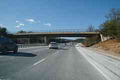
Without a bridge like this one, Maryland 100 and WB&A would have met at grade had the railroad still been operating. This bridge carries WB&A Road up and over busy 100, a route that, if ever completed, would serve as an outer beltway for Baltimore.


BWI Airport

BWI Airport
Mile: Date: Feb 2005
Ease: A View: N
Area: A EH:
Map: AA 7 D 2 Topographic Maps

Where WB&A Road meets Maryland 176, about 2 miles of former WB&A right of way are now inaccessible - except via aircraft. Former stops covered over by Baltimore-Washington International Airport runways include Kelly, Wellham, and Downs. Unlike on aircraft carriers, here cabling is not needed to snag landing planes, so the utility lines go underground.


<< Previous (southwest) | THIS PAGE: Patuxent River to BWI Airport | Next (northeast) >>

Or, return to main page

Copyright Notice