TrainWeb.org Facebook Page
B&O Washington Branch Photo Tour


B&O Washington Branch
Modern day photo tour

Accompanying each photo below are:

Click a photo to see a larger view. Please send your comments and corrections to Steve.


<< Previous (east) | THIS PAGE: Route 100 Industrial Park | Next (west) >>

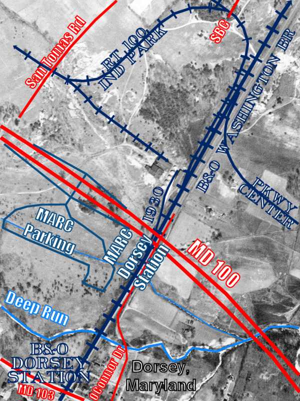
Brief Historical Background: Route 100 Industrial Park

Spurs
NEW! mid-Oct 2020

Spurs
Mile: 13.0 Date: Jan 2019
Ease: A View: NE
Area: B IC2:
Map: Ho 17 E 12, AA 1 B 11 Topographic Maps

As seen from Maryland 100 near Dorsey, at left a thin layer of snow contrasts with the steel rails of the Route 100 Industrial Park spur, also called the Dorsey Industrial track.

The wide, flat-graded area on the left originated long before CSX installed a signal there: starting around 1930, it hosted a siding for B&O's first industrial customer at Dorsey.


Aerial 1938
NEW! mid-Oct 2020

Aerial 1938
Mile: 13.0 Date: Apr 1938
Ease: View: N (up)
Area: IC2:
Map: Ho 17 E 12, AA 1 B 11 Topographic Maps

industry 1938 That siding is marked 1930 near the center of this aerial photo from 1938. Many modern features have been overlaid, including most of the Route 100 Industrial Park spur that is the subject of this tour page.

The magnified view at left shows what appear to be several tanks adjacent to the siding. The site was cleared during 1982 to make room for new industry. The current spur curls around to end very close to where the 1930 siding had ended. The siding began between what is now Maryland 100 and the masonry arch bridge that can be glimpsed under the passenger platforms of MARC's Dorsey Station. At left, that bridge is visible at the bottom left corner.


Spurs

Spurs
Mile: 13.0 Date: May 2002
Ease: B+ View: N
Area: B IC2:
Map: Ho 17 E 12, AA 1 B 11 Topographic Maps

The track into the Route 100 Industrial Park is notable for its steepness.

Some mid-20th century topographical maps show a pre-Route-100-Industrial-Park siding had avoided the steep climb and instead clung trackside here on the left.


Rusty Shiny
Photo courtesy Dave Hiteshew

Rusty Shiny
Mile: 13.0, spur 0.1 Date: May 2008
Ease: B View: N
Area: B IC2:
Map: Ho 17 E 11, AA 1 B 11 Topographic Maps

Of these two ascending into the Industrial Park, guess which sees more trains. The rusty set has been disconnected since photo time.


Snowy
Photo courtesy JP Frecker

Snowy
Mile: 13.0, spur 0.2 Date: Dec 2009
Ease: B+ View: S
Area: B IC2:
Map: Ho 17 E 11, AA 1 B 11 Topographic Maps
Neither rain nor the first snow of autumn 2009 shall prevent CSX from its appointed rounds on the spur. That's MD 100 in the distance.

Until the 1970s, a grade crossing of the main line in the vicinity of the engine had connected with OConnor Drive on the far side of the tracks. Prior to that, an unpaved OConnor Drive had wandered northeast to Smith Avenue.


Rail Brace
Photo courtesy Dave Hiteshew

Rail Brace
Mile: 13.0, spur 0.2 Date: May 2008
Ease: B View: W
Area: B IC2:
Map: Ho 17 E 11, AA 1 B 11 Topographic Map

This economy rail brace from W S Corp dates to 1928; in this case economy includes dyslexic letter stamping. The original 1930 siding was dismantled when the Route 100 Industrial Park spur was built during the 1970s. It is very possible this rail component had been part of the original siding, then reused on the 1970s spur.


Mirror 9

Mirror 9
Mile: Date: Jul 2002
Ease: A View: NW
Area: A IC2:
Map: Ho 14 E 7 Topographic Maps

A similar mirroring appears on this stone mile marker in Clarksville. The markers along the Ellicott City and Clarksville Turnpike (now MD 108) date to the 1869-construction of the 10-mile road by contractors John Oren and Harper Carroll along what had been Old Sandy Spring Road.

Leonardo da Vinci used mirror writing extensively, possibly to obfuscate documentation of his ideas from readers unfamiliar with the technique.


Santa Barbara Court
Photo courtesy Dave Hiteshew

Santa Barbara Court
Mile: 13.0, spur 0.3 Date: May 2008
Ease: A View: W
Area: B IC2:
Map: Ho 17 E 11, AA 1 B 11 Topographic Maps

The area at Santa Barbara Court looks nothing like the California town, but it does have the first grade crossing for the spur. The spur splits here, and will again further ahead. Note the boxcars in the distance, evidence this track comes to life sometimes. This location is marked SBC near the top of the 1938 aerial above.


New Rails
NEW! mid-Oct 2020

New Rails
Mile: 12.8 Date: Mar 2020
Ease: A View: W
Area: B IC2:
Map: Ho 17 E 11, AA 1 B 11 Topographic Maps

New rolling stock? No, new rails.

Look closely at the back of this unit to find a chain attached to a rail. That's a 500-foot segment of rail being dragged toward Santa Barbara Court for installation there.


Rising Grade
NEW! mid-Oct 2020

Rising Grade
Mile: 12.8 Date: Mar 2020
Ease: A View: NW
Area: B IC2:
Map: Ho 17 E 11, AA 1 B 11 Topographic Maps

The dragging reached and stopped at Santa Barbara Court. Deep zoom shows track work was also being done at a San Tomas Road grade crossing.

If the tracks appear to rise into the distance, it's because they do: the distant grade crossing is at an elevation 20 feet higher, making a grade of 2.3%. As of 2020, there remain a couple three active customers along the line, as evidenced by the distant boxcars.


Clawing
NEW! mid-Oct 2020

Clawing
Mile: 12.8 Date: Mar 2020
Ease: A View: W
Area: B IC2:
Map: Ho 17 E 11, AA 1 B 11 Topographic Maps

The new rail was to replace the closer of the old, so had to be scooped up and repositioned.


Prentice 2124
NEW! mid-Oct 2020

Prentice 2124
Mile: 12.8 Date: Mar 2020
Ease: A View: NW
Area: B IC2:
Map: Ho 17 E 11, AA 1 B 11 Topographic Maps

This bigger unit assists with the lifing. The new 500-foot segment weighs roughly 10 tons.


Finishing Up
NEW! mid-Oct 2020

Finishing Up
Mile: 13.0, spur 0.4 Date: Mar 2020
Ease: A View: E
Area: B IC2:
Map: Ho 17 E 11, AA 1 B 11 Topographic Maps

Meanwhile, at the San Tomas Road grade crossing workers apply finishing touches. This is one of two such crossings of that road.


Tamper RM 1956

Tamper RM 1956
Mile: 13.0, spur 0.4 Date: Apr 2018
Ease: A View: NE
Area: B IC2:
Map: Ho 17 E 11, AA 1 B 11 Topographic Maps

tamper control The spur is a convenient place to park some of that MoW equipment for the weekend.

A Ballast Tamper like this Harsco Mark IV HD is a sophisticated machine with laser sighting to measure the levelness of track. It can adjust the height to smooth dips and rises by vibrating the track. The Mark IV sold for in excess of $3 million when new during 2011.

The Millenium Falcon's laser cannon stations have nothing on this operator's control chair.


Tampers

Tampers
Mile: 13.0, spur 0.4 Date: Apr 2018
Ease: A View: W
Area: B IC2:
Map: Ho 17 E 11, AA 1 B 11 Topographic Maps

This is the active tamping part of a tamper. These arms contact the track or dig into the ballast to vibrate it to induce a sort of liquefaction that permits the track height to be raised or lowered to yield the desired levelness.


Regulator

Regulator
Mile: 13.0, spur 0.4 Date: Apr 2018
Ease: A View: N
Area: B IC2:
Map: Ho 17 E 11, AA 1 B 11 Topographic Maps

regulator control Bryan Park "The Rhino" Ballast Regulator has everything one needs for a day of pushing rocks around the rails -- except maybe a cupholder. Farmer Machine Company of Ashland, Virginia builds these machines to CSX specifications.

CSX's Maintenance-of-Way of equipment is itself maintained by the Bryan Park Roadway Shop in Richmond, Virginia.

Links: The Rhino, rolling to the next job


Give a Hoot
Photo courtesy Dave Hiteshew

Give a Hoot
Mile: 13.0, spur 0.4 Date: May 2008
Ease: A View: N
Area: B IC2:
Map: Ho 17 E 11, AA 1 B 11 Topographic Maps

...don't just toot.

Whenever I see these manual switch controls, this one given maintenance not long ago, I think of an owl. I also think of Jimmy Durante.


San Tomas Road
Photo courtesy Dave Hiteshew

San Tomas Road
Mile: 13.0, spur 0.6 Date: May 2008
Ease: A View: SE
Area: B IC2:
Map: Ho 17 D 11, AA 1 B 11 Topographic Maps

Deliveries arrive via the track on the left.


Pulled
Photo courtesy Kirk Nabors

Pulled
Mile: 13.0, spur 0.6 Date: Sep 2018
Ease: A View: NW
Area: B IC2:
Map: Ho 17 D 11, AA 1 B 11 Topographic Maps

Here's a delivery in progress. First the covered hoppers, such as MLLX 26358, get pulled past the switch and across San Tomas Road.


Pushed
Photo courtesy Kirk Nabors

Pushed
Mile: 13.0, spur 0.6 Date: Sep 2018
Ease: A View: E
Area: B IC2:
Map: Ho 17 D 11, AA 1 B 11 Topographic Maps

Then the switch is thrown, and in this case CSX 6446 reverses to push the covered hoppers onto the siding.


Pneumatic
Photo courtesy JP Frecker

Pneumatic
Mile: 13.0, spur 0.7 Date: Dec 2009
Ease: A View: E
Area: B IC2:
Map: Ho 17 D 11, AA 1 B 11 Topographic Maps

This main photo is from an earlier delivery. Somtimes the engine offloading 2018 pushes the covered hoppers far back between buildings.

Ths closeup at left of plastic pellet hoppers NDYX 879151 and CBFX 470195 dates from April 2018.

The pellets fall by gravity to the bottom of the hoppers where suction-driven air currents offload them along one of up to seven tubes into the manufacturing facility.

The tracks end in the distance very close to where the ~1930-built siding had.


High Road Low Road
Photo courtesy Dave Hiteshew

High Road Low Road
Mile: 13.0, spur 0.7 Date: May 2008
Ease: A View: S
Area: B IC2:
Map: Ho 17 D 11, AA 1 B 11 Topographic Maps

The spur's tracks diverge and curve to serve many warehouses, even ones at different elevations. That is MD 100 in the distance.


Dwarf CPL

Dwarf CPL
Mile: 12.9 Date: Dec 2008
Ease: B+ View: S
Area: B IC2:
Map: Ho 17 E 12, AA 1 B 12 Topographic Maps

Elves are busy at dusk on a chilly Chrismas Eve, so instead this dwarf CPL guards the mainline from rail traffic exiting the Route 100 Industrial Park spur.


New Signals

New Signals
Mile: 12.9 Date: Feb 2011
Ease: B+ View: S
Area: B IC2:
Map: Ho 17 E 12, AA 1 B 12 Topographic Maps

Much taller signals have taken on the job since then. The distant CPL knows its days are numbered (it was removed later in 2011).

On the next page, we'll resume where we left off the Washington Branch.


<< Previous (east) | THIS PAGE: Route 100 Industrial Park | Next (west) >>

Or, return to main page

Copyright Notice