TrainWeb.org Facebook Page
B&O Washington Branch Photo Tour


B&O Washington Branch
Modern day photo tour

Accompanying each photo below are:

Click a photo to see a larger view. Please send your comments and corrections to Steve.


<< Previous (east) | THIS PAGE: Hyattsville to Brentwood | Next (west) >>

Hyattsville

Hyattsville
Mile: 33.4 Date: Nov 2003
Ease: B+ View: NE
Area: B- IC2: 157
Map: PG 12 D 5 Topographic Maps

The wye here at Hyattsville allows the Alexandia Branch to split from the Washington Branch and take a more easterly route around downtown Washington, DC. The Alexandria Branch tracks are not seen in this photo, but are off to the right.

This view from within the wye looks northeast back toward the Alt US 1 overpass, as well as the concrete slab on the right where Hyattsville Station had been. The station survived into the 1950s and an adhacent B&O freight house into the 1980s.

Links: 1964


Hyattsville Wye

Hyattsville Wye
Mile: 33.4 Date: Nov 2003
Ease: B+ View: SW
Area: B- IC2:
Map: PG 12 D 5 Topographic Maps

This photo looks the opposite direction to the previous. Here you can see the so-called west leg of the wye (it's on the southeast side of the wye) splitting off to the Alexandria Branch, which is now on the left.

Immediately behind the pine trees on the right is US 1. About a mile in the distance is the overpass of 38th Avenue.

Links: 1940, 1940, 1940


Alexandria Branch

Alexandria Branch
Mile: 33.4 Date: Nov 2003
Ease: B+ View: E
Area: B- IC2:
Map: PG 12 D 5 Topographic Maps

And this view looks along the wye's west leg toward the start of the Alexandria Branch. On the left is the Alt US 1 bridge again, and the concrete slab even farther left is the former location of Hyattsville Station.


JD Sign

JD Sign
Mile: 33.6 Date: Apr 2004
Ease: A View: N
Area: B- IC2:
Map: PG 12 D 5 Topographic Maps

CSX removed JD Tower during the 1990s, but left behind this sign that had alerted trains of their approach to the tower.


CSX 690

CSX 690
Mile: 33.8 Date: Apr 2004
Ease: B View: SW
Area: B- IC2:
Map: PG 12 C 5 Topographic Maps

Red signals at Hyattsville stopped this eastbound train on a spring afternoon. Closest to the camera are defect detectors, then the bridge over Charles Armentrout Drive (newest bridge in the area). Next, where CSX 690 has paused, is the railroad bridge over the Anacostia River's Northwest Branch. About a mile in the distance is 38th Avenue, and even farther Eastern Avenue.

Links: sound recordings (WAV files) of defect detector 1, 2, 3, 4, 5


Brentwood
NEW! late-Dec 2023

Brentwood
Mile: 34.4 Date: Mar 2022
Ease: A- View: NE
Area: B IC2:
Map: PG 12 C 5 Topographic Maps

Deep zooming back from Bunker Hill Road's former grade crossing and the site of B&O's Brentwood Station finds enough heat distortion even in winter to make Track 2 appear to be dressed in a bowtie. Milepost 34 is the bright vertical rectangle at left. A B&O list from 1889 puts Highlands Station here.

Link: Brentwood Station ~1950


38th Avenue

38th Avenue
Mile: 34.6 Date: Nov 2003
Ease: A View: SW
Area: B IC2:
Map: PG 12 B 7 Topographic Maps

This is what happens when you violate the "keep the sun at your back" rule of photography. With better lighting, this is a nice spot for an overhead view of trains.

Fortunately, there's nothing of railroading significance to try to see through the glare in this view from 38th Avenue. About a half mile ahead, the tracks leave Maryland and cross with little fanfare into Washington, DC near mile marker 35 and the Eastern Avenue bridge glimpsed in the distance.


Eastern Avenue

Eastern Avenue
Mile: 35.0 Date: Jun 2004
Ease: B View: SW
Area: C IC2:
Map: PG 12 A 8 Topographic Maps

Eastern Avenue (background) designates the boundary between Maryland and Washington, DC. It's also near mile 35; a beaten-up stone milepost hides in brush on the left.

An 1878 GM Hopkins map puts Reeve's Station on the right just beyond the bend, perhaps at Central Avenue. Another source spells it Rives.


Langdon
NEW! late-Dec 2023

Langdon
Mile: 35.7 Date: Feb 2020
Ease: B+ View: SW
Area: B- IC2:
Map: PG 12 C 5 Topographic Maps

Between Eastern Avenue and Queens Chapel Road, the railroad runs in a slight cut, one deep enough to discourage industry from developing along it. Langdon Station had stood in this vicinity. A B&O list from 1889 calls it Mills Station instead.

Link: Langdon Station ~1950


Queens Chapel Road

Queens Chapel Road
Mile: 36.0 Date: Jun 2004
Ease: A View: SW
Area: C IC2:
Map: DC 10 J 10 Topographic Maps

It's quiet here, however as we'll see that changes past the bend and the Queens Chapel Road overpass in the distance.

B&O's Washington Branch track did not have this gentle curve prior to 1907 and the opening of Union Station, The track instead continued straight, and ran along what is now West Virigina Avenue.

An 1878 GM Hopkins map puts Montello Station in the southeast quadrant of the grade crossing with Queens Chapel Road.


Map 1907
Image courtesy Library of Congress

Map 1907
Mile: 36.2 Date: 1907
Ease: View: N (up)
Area: IC2:
Map: DC 10 J 10 Topographic Maps

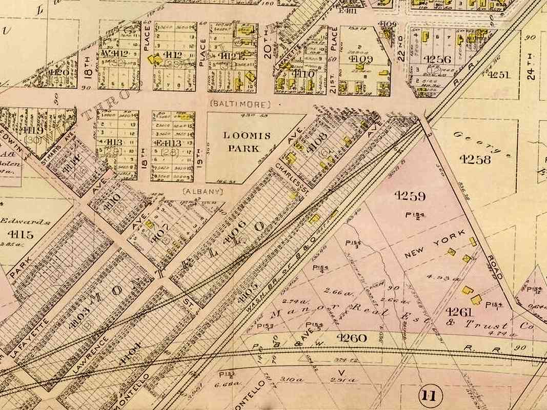
This Baist real estate map of 1907 captures B&O's curving realignment to facilitate access to DC's then-new Union Station. Queens Chapel Road runs diagonally from top toward lower right, where it is simply labelled "Road".

After passing southwest under Queens Chapel Road, B&O had continued straight where the Baltimore & Potomac (marked PB&W here, later Pennsylvania) 
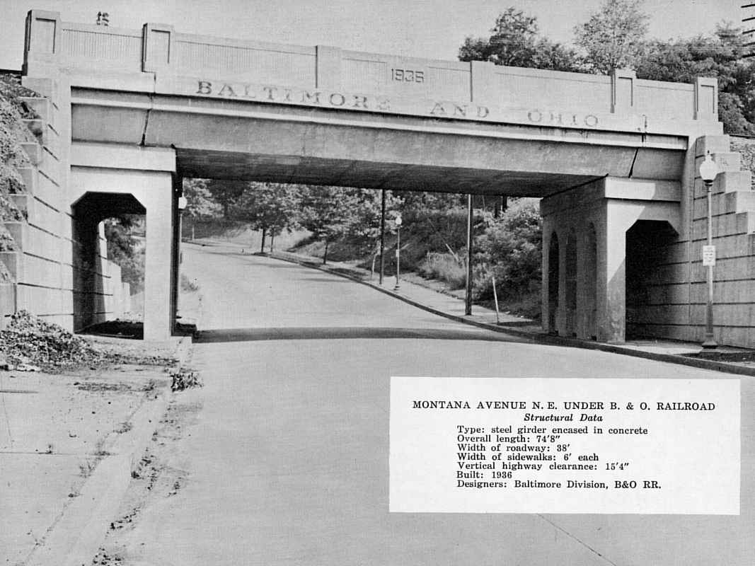
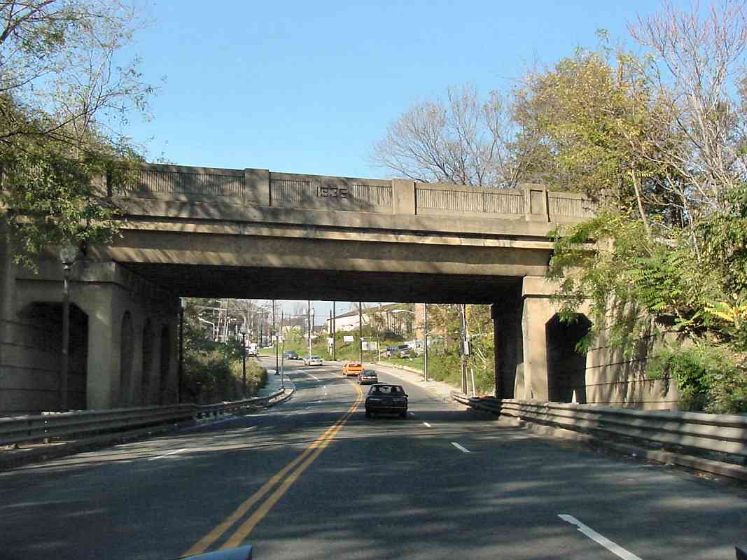
Railroad crossed at diamonds. Today that location is just east of where Montana Avenue passes under both railroads. On this map, Montana Avenue is labelled Edwin Street, and "(Baltimore)" is now Bryant Street.

The then-new B&O alignment curves west through the area of Montello, where the depicted street grid and housing lots existed only as a plan. Subsequent Baist-brand maps suggest B&O's original, uncurving alignment remained to serve local industry until New York Avenue was extended east to Bladensburg Road during the 1930s. When built, New York Avenue followed a more easterly route than the east-northeasterly plan depicted by this map.


Siding Culvert

Siding Culvert
Mile: 36.2 Date: Feb 2020
Ease: A- View: SE
Area: C IC2:
Map: DC 10 J 10 Topographic Maps

culvert Missing from the Baist map is this creek parallel to and southwest of Queens Chapel Road. As tempting as it is to call this box culvert a Washington Branch original, its location is not quite far enough southeast to match the path of that old alignment. Furthermore, the stone cutting style exhibited is that of the early 1900s, so this was likely a siding built at the time of the track realignment here for Union Station.


Toward Ivy City

Toward Ivy City
Mile: 36.3 Date: Feb 2020
Ease: B+ View: SW
Area: C IC2:
Map: DC 10 J 10 Topographic Maps

Deep zoom past B&O's bridge over Montana Avenue shows where B&O and Pennsylvania Railroads had met to run side-by-side on the way to Union Station. Ironically, the round color-position light (CPL) signals on the left are the ex-Pennsy, now Amtrak ones for its Northeast Corridor, whereas the in-line signals on the right are CSX's replacement for B&O's iconic CPLs.

Off photo right is a disused siding. B&O had served many Brentwood-area customers via sidings on both sides of the main.


Montana Avenue

Montana Avenue
Mile: 36.4 Date: Nov 2003
Ease: A View: N
Area: C IC2:
Map: DC 10 H 10, PG 11 H 10 Topographic Maps

With New York Avenue a short distance behind, this 1936-dated bridge carried B&O over Montana Avenue on its way to train yards (left). Immediately behind the photog is Pennsylvania Railroad's bridge, which serves the same purpose, but is not nearly as attractive looking.

Prior to the Union Station track realignment, B&O had a small station named Montello near this location.


Shared RoW

Shared RoW
Mile: 36.7 Date: Dec 2018
Ease: A View: E
Area: B- IC2:
Map: DC 10 H 11 Topographic Maps

Behind the Quality Inn near New York Avenue and 16th Street, the former railroad foes joined to begin sharing the route into downtown; for MARC commuters the two lines go by the names Camden and Penn. Emerging from behind the motel on the Camden Line is CSX 3061 in "Rock Runner" duty. As you might reason, "rock runner" is a generic name for a train that rolls crushed stone from mines to various distribution points.

B&O initially had a monopoly on railroad service to Washington but eventually Pennsy muscled in. Each RR had its own city station, making the downtown area and Mall busy with steam engines, unsightly steam engines according to the politicians.

In 1900, they "encouraged" the railroads to build a single, joint station, and in 1907 Union Station opened. Under the name Washington Terminal Company, B&O and PRR jointly constructed a shared alignment to the station, as well as the Ivy City repair shops.


Ivy City

Ivy City
Mile: 36.7 Date: Dec 2018
Ease: A View: W
Area: B- IC2:
Map: DC 10 H 11 Topographic Maps

The Rock Runner illustrates CSX's route through Ivy City, now dominated by Amtrak, MARC, and the Washington, DC Metro. This train is not bound for DC, but rather CSX's Metropolitan Subdivision where it can continue into the hills for a stone refill.

Union Station created the need for railroad support, such as repair shops. Ivy City Yard still serves in that capacity.

The containers adjacent New York Avenue at bottom left are part of "Hecht Town", essentially a publicity stunt to promote the redevelopment of the former Hecht Company warehouse on the south side of New York Avenue.


Track 1

Track 1
Mile: 36.7 Date: Dec 2018
Ease: A View: W
Area: B- IC2:
Map: DC 10 H 11 Topographic Maps

Both ends of the Rock Runner are visible as it crosses over the "waistline" of Ivy City Yard and follows Track 1 toward the CSX Metropolitan Subdivision. That's 9th Street spanning overhead.


F Tower Site
NEW! late-Dec 2023

F Tower Site
Mile: 37.0 Date: Mar 2022
Ease: B View: W
Area: C IC2: 394
Map: DC 10 G 11 Topographic Maps

The two nearest tracks are ex-PRR, Amtrak. The rightmost two curve to begin CSX's Metropolitan Subdivision at the pair of signals. One track barely visible between allows MARC Camden Line trains to reach Washington Union Station. B&O's F Tower had stood at this photo's right edge, adjacent the 9th Street overpass.

Link: 1974


Joint RoW

Joint RoW
Mile: 37.2 Date: Jul 2005
Ease: C View: E
Area: C- IC2: 232
Map: DC 10 F 11 Topographic Maps

The uncooperative (for railfanning) 9th Street overpass provides an overhead look back about a mile long. In this reverse view, the ex-B&O (now CSX) tracks on the left and the electrified ex-Pennsylvania RR tracks (now Amtrak) on the right transition into shared Washington Terminal trackage.

At the bottom of the photo, note the pair of ex-B&O tracks bends to the left: they are part of the large wye that now connects with CSX's Metropolitan Subdivision. The switch at the bottom leads a single track into Union Station. B&O's F tower had been here on the left; on page 232 of Impossible Challenge II it can be seen in a photo similar to this that dates from the 1940s.

B&O's right of way prior to the realignment had continued across what has become New York Avenue, passing close to the Hecht Company warehouse seen at upper right.

Link: ~1950


Ivy City Yard

Ivy City Yard
Mile: 37.2 Date: Jul 2005
Ease: C View: E
Area: C- IC2:
Map: DC 10 F 11 Topographic Maps

Amtrak's Ivy City repair center is north (left) of the joint RoW. Though this is not an exclusive former B&O operation, the yard is significant enough to warrant the next few photos.

The 9th Street overpass offers enough views to make any railfan's mouth water, but there is a reason this area is called the "holy grail of railfanning". Lots of trains, yes, but no place to park, a rough neighborhood, and if that wasn't enough, a once anthrax-contaminated post office (yes, this is where you can find the infamous Brentwood Postal Facility).


Amtrak 2036

Amtrak 2036
Mile: 37.1 Date: Jul 2005
Ease: A View: E
Area: C IC2:
Map: DC 10 G 11 Topographic Maps

From trackside it looks like Amtrak Acela 2036 has a sore nose. This is the same train seen at the extreme left of the prior photo.

Link: 1956


Amtrak 918

Amtrak 918
Mile: 36.8 Date: Jul 2005
Ease: B View: SW
Area: C IC2:
Map: DC 10 G 11 Topographic Maps

AMTK 918 gets reinvigorated at the train spa.


Wye

Wye
Mile: 37.2 Date: Jul 2005
Ease: C View: W
Area: C- IC2:
Map: DC 10 F 11 Topographic Maps

Back at the 9th Street overpass vantage point, but this time looking the opposite direction (west)...

The three tracks are left are the direct ones to Union Station. Below is the wye track that connects to the Metropolitan Branch. The 1873-opened Met extends from Washington north-northwest through Rockville and Gaithersburg to meet the Old Main Line at Point of Rocks, Maryland.

The two photos below zoom into the picture, first to the left, then to the right.

Links: 1940, 1940, 1940


Zoom Left

Zoom Left
Mile: 37.2 Date: Jul 2005
Ease: C View: SW
Area: C- IC2: 243, 272
Map: DC 10 F 11 Topographic Maps

Ahead the tracks bend toward Union Station. The closest of the three is followed by MARC Camden Line (Cap Sub) trains to Union Station. The empty foreground area was filled with new storage tracks during 2013.

That's the top of the Washington Monument at the extreme left.


Zoom Right

Zoom Right
Mile: 37.2 Date: Jul 2005
Ease: C View: NW
Area: C- IC2:
Map: DC 10 F 11 Topographic Maps

In 1976 some of Washington Terminal was transferred to the then-new DC Metro subway to become their Brentwood Shops. In the distance are several rows of Metro cars.

Reader Dave Manning disagrees with some of the details:

    "Eckington was still in service by the B&O in 1976 and NO part of it was ever transferred or used by WMATA. The only yard used to build Brentwood was the old Pullman yard and it was completely built and in service by 1976, along with the first segment of the Red Line. So, the only thing that happened in 1976 relative to Brentwood was that the Metro line here opened for service. In the photo you shot from the 9th St. bridge, Eckington would be between the Metro cars and that red brick warehouse in the center of the shot. The piggyback yard extended perpendicular to the main yard tracks and was off to the left."

Reader Eugene Leache provided some historical background:

    "Eckington was the estate of prominent journalist, and D.C. mayor, Joseph Gales. During the Civil War it was the site of a Union Army hospital."

Link: Eckington Yards 1923


AMTK 794

AMTK 794
Mile: 37.2 Date: Dec 2018
Ease: A View: SE
Area: C IC2:
Map: DC 10 F 11 Topographic Maps

Washington Terminal Company livery makes this rebuilt SW1000R stand out as it rolls under 9th Street. Built in 1953, in a previous life "WATC 794" was Montour 83.

Washington Terminal Company is almost wholly owned by Amtrak. Its job is to push and pull rail equipment around Union Station / Washington Terminal.

Links: MTR 83, more 794 pics


<< Previous (east) | THIS PAGE: Hyattsville to Brentwood | Next (west) >>

Or, return to main page for other tours.

Copyright Notice