TrainWeb.org Facebook Page
B&O Washington Branch Photo Tour


B&O Washington Branch
Modern day photo tour

Accompanying each photo below are:

Click a photo to see a larger view. Please send your comments and corrections to Steve.


<< Previous (east) | THIS PAGE: Montevideo to Bridewell | Next (Waterloo branch) >>

Licking Run

Licking Run
Mile: 14.5 Date: May 2002
Ease: C View: NW
Area: B IC2:
Map: AA 5 K 1, Ho 20 E 12 Topographic Maps

With help from paths made by dirt bikers, it was possible to wind your way down from the tracks to this 1835-era culvert. It's been shored up since with concrete (and spray paint), but someone has created a walkway to the entrance. Are people crazy enough to dirt bike through here? The opening is about 4 feet high.

This stream is unnamed on the ADC maps. A rule of thumb: unnamed streams on the ADC maps are usually spanned via culverts, and named streams are usually spanned via stone arched or steel bridges. An 1860 Martenet's map names this stream "Licking Run".


Stringers

Stringers
Mile: 14.5 Date: May 2002
Ease: C View: N
Area: B IC2:
Map: AA 5 K 1, Ho 20 E 12 Topographic Maps

But the real surprise comes if you employ the wooden walkway to get close enough to the culvert to look inside: many of the granite blocks are recycled stone stringers! These had been used for the initial (circa 1830) track construction on the Old Main Line. I've marked with small circles some of the holes where the iron strap rail had been affixed to the heavy blocks.

In 1830 these blocks had been hewn by hand, and B&O wasn't one to waste all that effort. When the stringers proved unacceptable as a track bed on the OML, B&O pulled most of them up, and obviously hauled some here.

This is one of only two known bridges/culverts to have been built primarily with the recycled stringers, but there are likely others waiting to be discovered.


Collapse
Photo courtesy Dave Hiteshew

Collapse
Mile: 14.5 Date: Mar 2007
Ease: C View: NW
Area: B IC2:
Map: AA 5 K 1, Ho 20 E 12 Topographic Maps

During 2007 the stringer culvert's concrete cap gave way. CSX deemed the remaining structure safe so merely tossed some erosion-reducing stone blocks down the embankment. Trees have since regrown in this area.


MARC 74
Updated mid-May 2023

MARC 74
Mile: 14.7 Date: Sep 2017
Ease: A View: S
Area: B IC2:
Map: Ho 20 E 12, AA 5 K 1 Topographic Maps

Mar 2022 MARC 74 speeds commuters past Burnettes Spur. Though here the spur looks disused, railcars were seen on it during 2022 (left).

Per their web site, the Burnette company manufactures "technical polyurethane foams for the use in transportation, medical, acoustical, personal care, and other markets."


Disused Siding
NEW! mid-May 2023

Disused Siding
Mile: 14.8 Date: May 2022
Ease: A View: NE
Area: B IC2:
Map: Ho 20 D 13 Topographic Maps

Rails embedded in the pavement attest to a former siding. Old aerial photos are of insufficient resolution to reveal when this siding was last active.


Montevideo Road
NEW! mid-May 2023

Montevideo Road
Mile: 14.9 Date: Dec 2021
Ease: A View: SE
Area: B IC2:
Map: Ho 20 D 13 Topographic Maps

A motorcyclist pauses to watch CSX 6540 glide past, preceded by CSX 4310. Plans have existed for decades to build an overpass for Montevideo Road, one of the busiest grade crossings on the line.


CSX 7534

CSX 7534
Mile: 14.9 Date: Feb 2000
Ease: A View: NE
Area: B IC2:
Map: Ho 20 D 13 Topographic Maps

CSX 7534 model C40-8 barrels southwest past dirty mounds of snow toward Montevideo Road. CSX later sold the unit to Maine Central.

Link: MEC 7534 in Pan Am paint


CSX 997

CSX 997
Mile: 14.9 Date: Apr 2021
Ease: A View: NE
Area: B IC2:
Map: Ho 20 D 13 Topographic Maps

A run-in with a tree put an eye out, but CSX 997 tore off one of the tree's limbs to carry proudly as a souvenir. CSX 3051 trails.


Meet
NEW! mid-May 2023

Meet
Mile: 14.9 Date: Oct 2021
Ease: A View: NE
Area: B IC2:
Map: Ho 20 D 13 Topographic Maps

CSX 903905 Caboose 903905 and CSX 3411 meet.

Many cabooses have been repurposed as a shoving platform, a station for a crew member who checks the rails ahead are clear as the local consist behind him is pushed. In this case, a flatcar follows, itself sometimes used as a shoving platform.


CSX 2054
Updated mid-May 2023

CSX 2054
Mile: 14.9 Date: Oct 2021
Ease: A View: S
Area: B IC2:
Map: Ho 20 D 13 Topographic Maps

Montiviedo Road The shoving was being done by CSX 6503 and CSX 2054, the latter rebuilt into model GP38-3 form by CSX's Huntington shop.

In multiple railroad references, I have seen this, umm, let's call it an alternate spelling of the grade crossing road's name. I'd guess some master document has it spelled Montiviedo. The other side of this box shows the more-common Montevideo spelling.

An 1878 map places a B&O station in the northeast quadrant of this grade crossing. A B&O list from 1889 calls it Wayman Grove Station.


Milepost 15

Milepost 15
Mile: 15.0 Date: Sep 2003
Ease: B View: SE
Area: B IC2:
Map: AA 5 J 3, Ho 20 D 13 Topographic Maps

All the milestones I've located so far are on the Anne Arundel county side of the tracks. This one is tucked away so deep in the brush it's easily missed. Since photo time, this taken-for-gran1te stone has been removed.

At roughly this location over on US Route 1 had stood the One-Spot Flea Killer factory with its dog-shaped building. The site, in the southwest quadrant of US 1 and Hicks Road, is now occupied by a Super 8 motel.

Link: One-Spot Flea Killer


Jessup Station

Jessup Station
Mile: 15.7 Date: Sep 2000
Ease: A View: NE
Area: B IC2: 312
Map: AA 5 G 4, Ho 20 K 5 Topographic Maps

Under a sky of puffy cumulus clouds, CSX 682 heads a westbound train of containers through Jessup on track 1. It was one of a handful of engines to be painted with not one but two lightning bolts at its number.

An 1870s map shows B&O's Pierceland / Hooversville Station within the northeast quadrant of this former grade crossing, about where the passenger waiting shack is on the right. The Jessup Road grade crossing was initially eliminated during 1942, and the bridge rebuilt during 1975.

Link: 1975


MARC 7761
NEW! mid-May 2023

MARC 7761
Mile: 15.7 Date: Jan 2022
Ease: A- View: NE
Area: B IC2:
Map: Ho 20 K 5, AA 5 G 4 Topographic Maps

The waiting shacks are gone, but Jessup is still a MARC stop. MARC's single-level cars like this were built by Sumitomo/Nippon Sharyo during the early 1990s.


Jessup Road

Jessup Road
Mile: 15.7 Date: Sep 2000
Ease: A View: SW
Area: B IC2: 312
Map: AA 5 G 4, Ho 20 K 5 Topographic Maps

As of 2023, clearance at MD 175's / Jessup Road's bridge has not yet been signal expanded to permit passage of double stacks. The scene still looks much the same as in this 2000 photo except CSX has swapped out the CPL signals for their new counterparts, such as that at right.

Given the amount of effort CSX has expended since the mid-2000s to eradicate B&O's CPL signals, one might expect they'd use the opportunity to simultaneously convert to LEDs, but that did not happen, at least not here. Along the Penn Line, Amtrak has been changing signals from incandescent to LED. There is a downside to the LEDs though: they do not generate enough heat to melt snow, so are at risk of being obscured by a snowstorm.

Links: 1994, 2011


MARC 68

MARC 68
Mile: 15.7 Date: Jul 2018
Ease: A- View: S
Area: B IC2:
Map: Ho 20 K 5, AA 5 G 4 Topographic Maps

MARC's last remaining model GP40WH-2 engine in revenue service pushes through Jessup at 80 mph. This had been Conrail engine 3205. MARC 17 is along for the ride.

Link: MARC 68 pics


MARC 85
NEW! mid-May 2023

MARC 85
Mile: 15.7 Date: Jul 2022
Ease: A- View: SW
Area: B IC2:
Map: AA 5 G 4, Ho 20 K 5 Topographic Maps

One of MARC's SC-44 units charges through Jessup.


Jessup Parking

Jessup Parking
Mile: 15.7 Date: Sep 2017
Ease: A View: S
Area: B IC2: 312
Map: AA 5 G 4, Ho 20 K 5 Topographic Maps

The Jessup commuter station has parking room for about 50 cars but even on a weekday it goes underutilized. Signs of this style were erected at all MARC stations during the 2010s.


Prison Spur
NEW! mid-May 2023

Prison Spur
Mile: 16.0 Date: Apr 2021
Ease: B View: SE
Area: B IC2:
Map: AA 5 G 5, Ho 20 J 5 Topographic Maps

This pole line amd some concrete are all that remain of a former spur that brought coal to the prison at Jessup. The spur shows up first on 1907 USGS topo maps, and is visible in aerial photos into the 1960s after which it was removed when the prison shifted away from coal for heating. Perhaps during the early decades prisoners were also transported via train.


Weld

Weld
Mile: 16.0 Date: Sep 2003
Ease: B View: SE
Area: B IC2:
Map: AA 5 G 5, Ho 20 J 5 Topographic Maps

Mr. Carnegie, meet Mr. Illinois.

Two rails, from two different manufacturing plants, from two different years, become one via continuously welded rail, aka "ribbon rail".


MARC

MARC
Mile: 16.1 Date: Sep 2003
Ease: B View: NE
Area: B IC2:
Map: AA 5 G 5, Ho 20 J 5 Topographic Maps

Churning a cloud of dust behind, MARC engine 61 pushes this set of 3 commuter cars toward DC during an early autumn afternoon. To reduce the need for turning, MARC engines are designed for remote operation from the end passenger car, in this case MARC 7756

In the foreground is one of only two concrete whistle signs I've seen surviving on the Washington Branch.


New Signals

New Signals
Mile: 16.1 Date: Sep 2017
Ease: B View: NE
Area: B IC2:
Map: AA 5 G 5, Ho 20 J 5 Topographic Maps

Checking the site 14 years later finds new signals.

Too small to be worth showing is a concrete block on the right just beyond the signals, the last relic of a spur that brought coal to the prison at Jessup. The spur shows up first on 1907 USGS topo maps, and is visible in aerial photos into the 1960s after which it was removed when the prison shifted away from coal for heating. Perhaps during the early decades prisoners were also transported via train.


Widening

Widening
Mile: 16.2 Date: Apr 2021
Ease: B View: S
Area: B IC2:
Map: Ho 20 J 6 Topographic Maps

CSX installed retaining walls (unseen on right) on the northwest side of the line in preparation for one more track into Jessup Yard (distant left).


Not Wye

Not Wye
Mile: 16.2 Date: Apr 2021
Ease: B View: NE
Area: B IC2:
Map: Ho 20 J 6 Topographic Maps

This connection with the Waterloo Branch (foreground, and subject of the next tour page) was not remade into a wye. Jessup Yard already has a wye closer to it should the need arise to turn an engine around.


Signals

Signals
Mile: 16.2 Date: Apr 2001
Ease: B View: NE
Area: B IC2:
Map: Ho 20 J 6 Topographic Maps

Despite heat-induced atmospheric distortion, with digital camera at max zoom in the past, we could look almost a half mile north back toward Jessup Station to find the old color position light signals. Since then, CSX has replaced all but a few CPLs.

The bridge in the distance carries MD 175 over the tracks.

The amber signal seen here means "Medium Approach Medium", that is, proceed at medium speed approaching the next signal at medium speed.

Reader Ralph Hough wrote:

    "hey steve. i am a conductor for csx and i was looking at your website. very nice site i thought. i really enjoy learning the history of the b&o. one thing i need to bring to your attention is mile 7.2 picture (signals) the amber signal is 'approach' not 'medium approach medium'. i followed your link to mikes signal page and he has it wrong also. again, very nice website. i will be stopping back frequently. thanks...."

Ex-B&Oer Mike Blair added detail:

    "Conductor Hough is quite correct that the one displayed in your picture is an approach signal and would require The engineer to immediately reduce to medium speed and approach the signal at Dorsey prepared to stop. ( !! UNLESS his train was greater than 7300 feet long ! In which case he would have to act quickly to stop at Montevideo Road to avoid blocking the roadway, since trains greater than that length will not fit between the road and Dorsey signal.)"

Links to illustrated descriptions of signals: Mike's B&O Signals Page, Todd's CPL Home Page


Insulators

Insulators
Mile: 16.3 Date: Sep 2002
Ease: B View: SE
Area: B IC2:
Map: Ho 20 J 6 Topographic Maps

A little-known fact is during the 1880s B&O had its own telegraph company with wires that extended from Boston, Massachusetts to Galveston, Texas. Its slogan was "New Lines, Low Rates". B&O sold the company during 1887 to Western Union who continued to transmit telegrams until January 27, 2006.

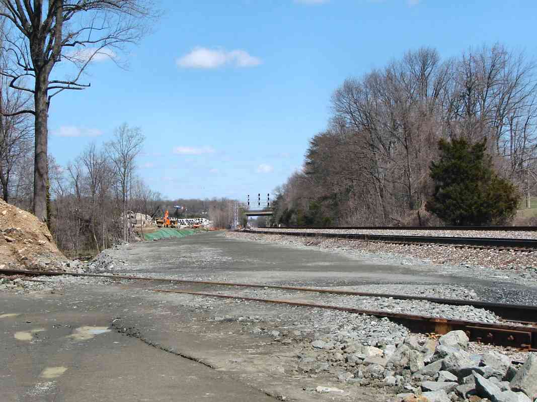
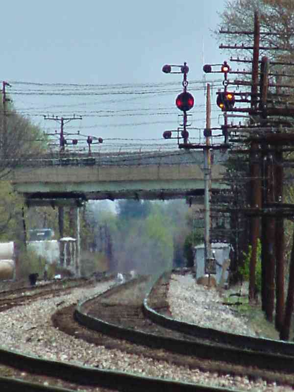
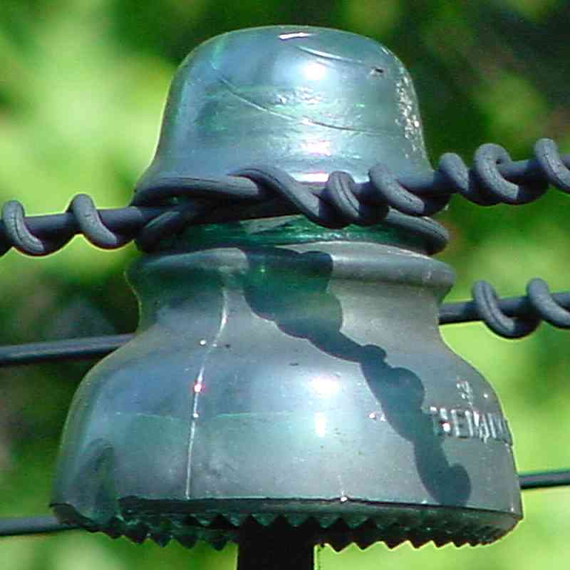
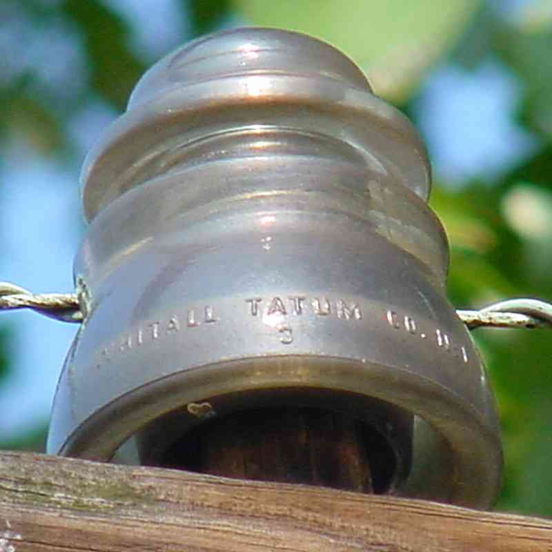
Before the 2000s when CSX removed the disused utility poles lining their routes in the region, insulators by the thousands still adorned the tired poles. The Old Main Line was fitted with a high percentage of plastic insulators, but along the Washington Branch collector-favored glass insulators survived in an array of styles and colors.

mounted Made in U.S.A. plastic Hemingray Whitall Tatum
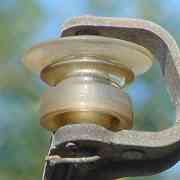
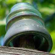
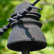
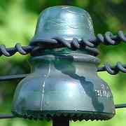
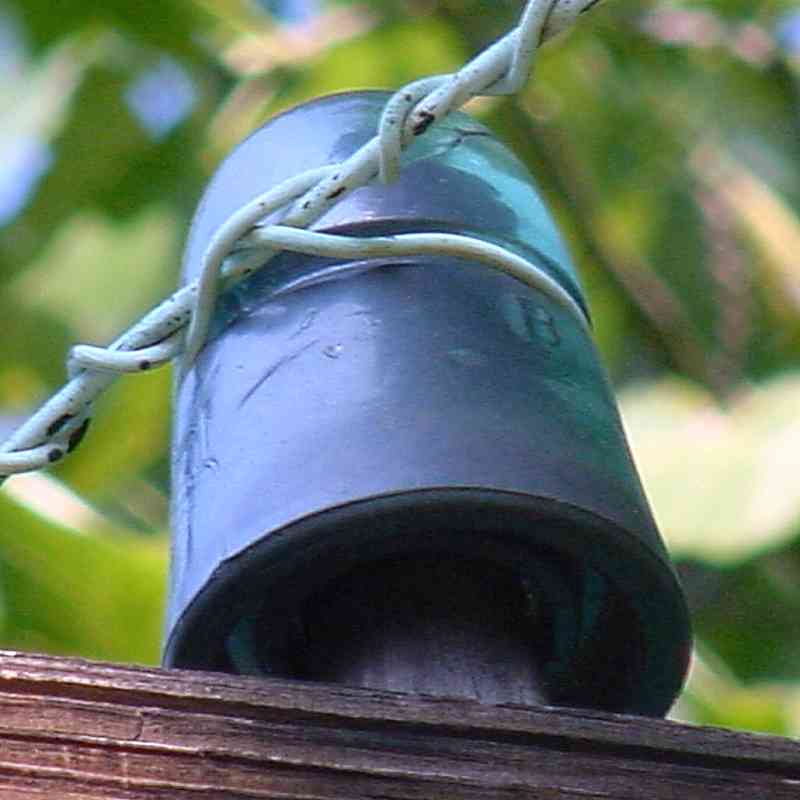
Many people collect insulators and therefore know them much better than me. Trackside I saw fewer of the one at top than the others. Collectors prize insulators of certain colors and manufacturers. Some of those illustrated were made by Hemingray, perhaps the one at top by Brookfield. If anyone cares to ID those here I'll be happy to add the details.

Links: B&O telegram, insulator photos, insulator list


Seven Dwarves

Seven Dwarves
Mile: 16.2 Date: Dec 2021
Ease: B View: S
Area: B IC2:
Map: Ho 20 J 6 Topographic Maps

With the 2021 addition of a second track into Jessup Yard, CSX installed dwarf signals that are numbered, the only such application of which I've seen.


jockeying

Jockeying
Mile: 16.2 Date: Dec 2021
Ease: B View: S
Area: B IC2:
Map: Ho 20 J 6 Topographic Maps

As an autorack train reaches each numbered dwarf, the signal changes to a very holiday-appropriate green-over-red. I believe these signals are intended to instruct not a train approaching from behind the camera, but rather CSX 7259 as it jockeys back and forth to gather empty autoracks.


Dorsey Run

Dorsey Run
Mile: 16.3 Date: Apr 2001
Ease: B View: NW
Area: B IC2:
Map: AA 5 G 6, Ho 20 J 6 Topographic Maps

bridge 17b This B&O bridge over Dorsey Run is the only one I've found with both brick arch and brick interior walls. Its masonry appears more modern than that found in brick arch examples dating to the 1870s. I suspect brick was used to reline an original stone arch here, or this could be the last brick arch bridge built by B&O.

The stones in the foreground, near the base of the large tree, are evidence of an older bridge, one for the road that had been the adjacent prison's south entrance. B&O's 1917 Form 6 places Bridewell Station at this milepost.


1969 Widening

1969 Widening
Mile: 16.3 Date: Apr 2021
Ease: B View: S
Area: B IC2:
Map: Ho 20 J 6, AA 5 G 6 Topographic Maps

The upstream end is archless and appears to be a 1969 addition to support one lead track into the then-new Jessup Yard.


2021 Widening
NEW! mid-May 2023

2021 Widening
Mile: 16.3 Date: Jan 2023
Ease: B View: SE
Area: B IC2:
Map: Ho 20 J 6, AA 5 G 6 Topographic Maps

Barboursville bridge To make room for a second Jessup Yard lead, the bridge was extended again in 2021 via an overhanging structure created by CSX's Barboursville Bridge Shop in West Virginia. Its foundation appears to stand independent of both the original bridge and its 1969 extension.

About 200 feet beyond at the red car are the noisy grounds of the Jessup Correctional Institution, formerly the Maryland House of Correction, aka "the Cut". Multiple guard towers overlook this bridge.


<< Previous (east) | THIS PAGE: Montevideo to Bridewell | Next (Waterloo branch) >>

Or, return to main page

Copyright Notice