TrainWeb.org Facebook Page
PRR / Amtrak Photo Tour


PRR / Amtrak in Maryland
Modern day photo tour

Accompanying each photo below are:

Click a photo to see a larger view. Please send your comments and corrections to Steve.


Special Note: >>> The places described on this page host quiet, high-speed trains. Stay well clear! <<<

<< Previous (north) | THIS PAGE: Winans to Patapsco | Next (south) >>

Signal Pole
Photos courtesy Dave Hiteshew

Signal Pole
Mile: 103.5 Date: Aug 2007
Ease: B View: S
Area: B T6:
Map: Ba 42 A 11 Topographic Maps

pole The skeletal remains of a PRR pole-mounted signal stand on the left. This is the only such survivor of which I know along the Penn Line. In Baltimore there's a similar signal skeleton but it is mounted on a catenary pole.

The link shows an example of the latter at Magnolia, Maryland.

Link: 1976


Culvert

Culvert
Mile: 103.6 Date: Feb 2019
Ease: B- View: NE
Area: B T6:
Map: Ba 42 A 11 Topographic Maps

Aerial photos suggest this concrete model replaced a B&P stone box culvert when PRR added a third track during the 1930s. Culvert inlets like this need to be cleared periodically to maintain throughput otherwise the next heavy rain might overflow the culvert -- and the tracks.


Meet the B&O
Photos courtesy Dave Hiteshew

Meet the B&O
Mile: 103.7 Date: Aug 2007
Ease: B- View: S
Area: B T6: 328, 343
Map: Ba 42 A 11 Topographic Maps

Winans Arch was not wide enough for the third track PRR wanted. While planning a new bridge, PRR also made provisions B.O.R.R for a fourth track, hence the extra room under B&O (now CSX) here. The bridge's builder's plaque reads McClintic-Marshall Corporation 1934.

There are four ex-B&O tracks above, making it a 4-track-over-3-tracks grade separation, soon to be 4 over 4, the most in the area. Someone asked me if there exists in the present day USA a wider, non-yard, grade separation of two rail lines, such as 5-tracks-over-5-tracks. I know of a 6-over-8 in Chicago (northeast of where I-94 and I-57 meet). No one has been able to top that.


Speed Blur

Speed Blur
Mile: 103.8 Date: Apr 2000
Ease: B View: N
Area: B T6: 328
Map: Ba 42 A 11 Topographic Maps

Departing Baltimore, B&P (PRR) opted for a route west of B&O, but here switches to the east. From this point down to Washington, DC, the ROW will remain on the east side of B&O's. B&O in 1835 chose a more inland route, one closer to the fall line where it could serve the various early factories and small towns that had already dotted the central Maryland landscape.

By contrast, this route B&P surveyed during the 1850s was through more sparsely settled areas, and at a lower elevation. This meant its track could be straighter, necessitating fewer cuts through high ridges and fewer tall bridges.

Change for: B&O tour at this site


Signal Mounts

Signal Mounts
Mile: 103.8 Date: Feb 2019
Ease: B- View: E
Area: B T6:
Map: Ba 42 A 11 Topographic Maps

signal mounts PRR had at one time affixed signals to the south side of the B&O bridge. The mounting hardware is all that remains, perhaps left behind because the bridge is not Amtrak property. These are the only disused overhead signal mounts (more than just brackets) I have found along the line. A westbound CSX freight was rumbling above as this Amtrak train passed below.


Washouts

Washouts
Mile: 103.8 Date: Feb 2019
Ease: B View: S
Area: B T6:
Map: Ba 42 A 11 Topographic Maps

The Penn Line follows Gadsby's Run south. Heavy rains during 2018 caused some trackside washouts here, as revealed by the replacement, larger stone ballast visually above MARC 28.


Amtrak 2032

Amtrak 2032
Mile: 104.0 Date: Feb 2019
Ease: B- View: S
Area: B T6:
Map: Ba 41 K 12 Topographic Maps

A different kind of washout, this time the dreaded sun glare, strikes again. In the distance is I-895.


Under I-895

Under I-895
Mile: 104.2 Date: Nov 2002
Ease: B- View: S
Area: B T6:
Map: Ba 41 K 12 Topographic Maps

Arriving during 1957, the I-895 Baltimore Harbor Tunnel Thruway was the first limited-access highway to cast a shadow on the Penn Line in the Baltimore area.


Serious Maintenance

Serious Maintenance
Mile: 104.2 Date: Aug 2017
Ease: A View: SW
Area: B+ T6:
Map: Ba 41 K 12 Topographic Maps

Amtrak takes track maintenance seriously. As viewed from I-895, that's quite a stretch of MoW equipment.

PRR spaced the tall catenary poles about 270 feet apart along straight track. Since this equipment spans about 4 poles, we can quickly calculate it stretches about 1000 feet, or more than 3 football fields.

A farm's grade crossing was found at photo bottom right before I-895 arrived during the 1950s.

Link: Amtrak catenary repair


Santa Fe

Santa Fe
Mile: 104.3 Date: Nov 2002
Ease: C View: E
Area: B+ T6:
Map: Ba 41 K 13 Topographic Maps

Concrete crossties courtesy the Santa Fe? That's how they are stamped. These were made by San-Vel Concrete company, and are intended to last 50 years, which is 10 to 20 more years than a wooden tie. Concrete ties cost about twice as much as a wooden tie.


Patapsco Bridge

Patapsco Bridge
Mile: 104.3 Date: Nov 2002
Ease: C View: SE
Area: B+ T6: 343
Map: Ba 41 K 13 Topographic Maps

Compared to B&O's grand Thomas Viaduct located about two miles upstream, the Penn Line's bridge across the Patapsco River is positively mundane. Undoubtably, it was also much less costly to construct. It was not built until after Elkridge Landing upstream had ceased being a viable port.

The steelwork on this side of the bridge appears to date from a widening during 1898, whereas that on the other side is newer, perhaps rebuilt around 1990.


Downstream Side

Downstream Side
Mile: 104.3 Date: Nov 2002
Ease: C View: S
Area: B+ T6: 343
Map: Ba 41 K 13 Topographic Maps

The piers with reddish stone and angular ends are original B&P construction circa 1870. To reduce flooding concerns, during 1898 the Wilson Brothers Company contracted to lengthen the bridge via three new stone piers. Those 1928 have rounded ends, such as the closest in this view. At the same time the company likely also widened the bridge from two to three tracks.

The "1928" embossed in concrete reveals when the piers were widened on this, the downstream side, in preparation for electrification of the line.

A fourth track is scheduled for addition here during the 2020s. Whether that will require a total rebuild of this bridge is not yet clear. Perhaps it can be tacked on in the manner of the prior expansions.

Link: 1885


Deferred Maintenance

Deferred Maintenance
Mile: 104.3 Date: Nov 2002
Ease: C View: E
Area: B+ T6:
Map: Ba 41 K 13 Topographic Maps

Amtrak is desperately in need of a "round tuit" when it comes to repainting the bridges they inherited. At photo time it was in excess of a half century since the steel portions of the Patapsco Bridge last received a coat of paint.

When this bridge was painted during September 1952, Amtrak was but a gleam in some government bureaucrat's eye, Pennsy Pacific K4 steamers were still hauling passengers, and President Harry S Truman was busy with a police action in Korea.


Icy Patapsco
Photo courtesy Johns Hopkins University

Icy Patapsco
Mile: Date: winter 1926/1927
Ease: View: N (up)
Area: T6:
Map: AA 1 Topographic Maps

Patapsco grade crossing This wintry photo predates electrification of the line. Careful pixel counting of width versus height of the bridge over the Patapsco River, and comparing those measurements with modern ones, suggests by 1927 the bridge carried 3 tracks.

The river appears to be sufficiently frozen for vehicles to traverse it then diagonally cross the tracks at the south end of the bridge where a locomotive is poised on the rightmost track. Surveys or other preparations to erect catenary poles astride the bridge may have begun by photo time.


Widened

Widened
Mile: 104.4 Date: Oct 2018
Ease: B View: N
Area: B+ T6: 343
Map: AA 1 K 5 Topographic Maps

levered Concrete added to both sides of some bridge piers was so meticulously linked with the prior stonework that no failures are apparent even after a century or so. The piers have managed the additional stress of supporting cantilevered catenary poles. Even the geese look suitably impressed.

At the river the line enters Patapsco State Park for a brief visit. That's the same park through which much of B&O's Old Main Line treks.


MARC 4901
Photo courtesy Dave Hiteshew

MARC 4901
Mile: 104.4 Date: Oct 2009
Ease: B- View: W
Area: B+ T6:
Map: AA 1 K 5 Topographic Maps

Dusk comes earlier and earlier during autumn.

At roughly 500 feet, this bridge over the Patapsco is the line's longest between Catonsville, Maryland and Washington, DC.


Time Warp

Time Warp
Mile: 104.4 Date: Oct 2018
Ease: B- View: NE
Area: B T6:
Map: AA 1 K 5 Topographic Maps

Beatles and Springsteen graffiti? Something tells me the water level adjacent this pier was lower during the 1970s.

The newer / older sections of this pier are evident; graffiti like Bing Crosby croons! would better match the electrification time period.


Amtrak 2023
Photo courtesy Dave Hiteshew

Amtrak 2023
Mile: 104.4 Date: Oct 2009
Ease: B View: N
Area: B+ T6:
Map: AA 1 K 5 Topographic Maps

Into the 21st Century the Patapsco River bridge has hosted 3 tracks but no more. Efforts have begun to add a fourth track between Halethorpe and Odenton, more specifically, between the Winans and Grove interlockings. The project's $600 million funding sounds insufficient to include a new bridge here.

The Amtrak lettering on the nose of the Acela units came in various colors until standardized to blue during 2013.


Arundel Sand and Gravel
Photo courtesy Johns Hopkins University

Arundel Sand and Gravel
Mile: Date: Apr 1938
Ease: View: N (up)
Area: T6:
Map: AA 1 Topographic Maps

By this time of this 1938 aerial, the line had been electrified; that's the Patapsco River bridge at upper left.

Served by PRR sidings to the east was the Arundel Sand and Gravel Company that began operation here during 1917. At peak it produced 30000 to 40000 tons of sand and gravel per day.


MARC 63
Photo courtesy Dave Hiteshew

MARC 63
Mile: 104.5 Date: Oct 2009
Ease: B View: S
Area: B+ T6:
Map: AA 1 K 5 Topographic Maps

Prior to the sand and gravel company, the site (left in this view) was home to an iron forge and mill known as Stoney Run Hills.

In the distance, I-195 bridges the tracks.

Link: iron forge here


Amtrak 2027

Amtrak 2027
Mile: 104.7 Date: Oct 2018
Ease: B+ View: S
Area: B+ T6:
Map: AA 1 K 6 Topographic Maps

Two very different Amtrak engines meet near I-195.


Amtrak 512

Amtrak 512
Mile: 104.7 Date: Oct 2018
Ease: B+ View: W
Area: B+ T6:
Map: AA 1 K 6 Topographic Maps

Amtrak 512 Amtrak's new solar-powered locomotive occupies the center track while hooked up for a recharge.

No, actually that's AMTK 512, a GE model B32-8WH, in barricade duty while workers repair the center track. This 1991-built unit was given its Phase V paint scheme during 2015. The solar panel powers a track greaser.

Link: more AMTK 512 pics


MoW

MoW
Mile: 104.9 Date: Dec 2017
Ease: B+ View: N
Area: B T6:
Map: AA 1 K 6 Topographic Maps

This self-powered catenary maintenance vehicle rolled into I-195's shadow, its windshield wipers also serving as windshield washers.


Furnace Avenue

Furnace Avenue
Mile: 104.9 Date: Nov 1999
Ease: A View: E
Area: B T6:
Map: AA 1 J 6 Topographic Maps

On the east side of Elkridge stands the line's oldest surviving underpass between Baltimore and Washington. This is likely a B&P original that dates to the decade of the 1860s. Like the bridge over the Patapsco, the western side of this one appears to have been widened for track three. Four tracks might not fit, meaning this bridge might be completely replaced during the 2020s, so don't delay if you want photos. The clock is similarly ticking on a few remaining original B&P bridges south of here.

Of much newer construction is I-195 which towers behind the narrow Furnace Avenue underpass. In the foreground is Stoney Run, a stream the RR parallels for several miles as it, and we, continue south to Severn, Maryland.


Movin' On
Screen captures via fair use

Movin' On
Mile: 104.9 Date: 1975 (Oct 2017)
Ease: A View: W
Area: B T6:
Map: AA 1 K 6 Topographic Maps

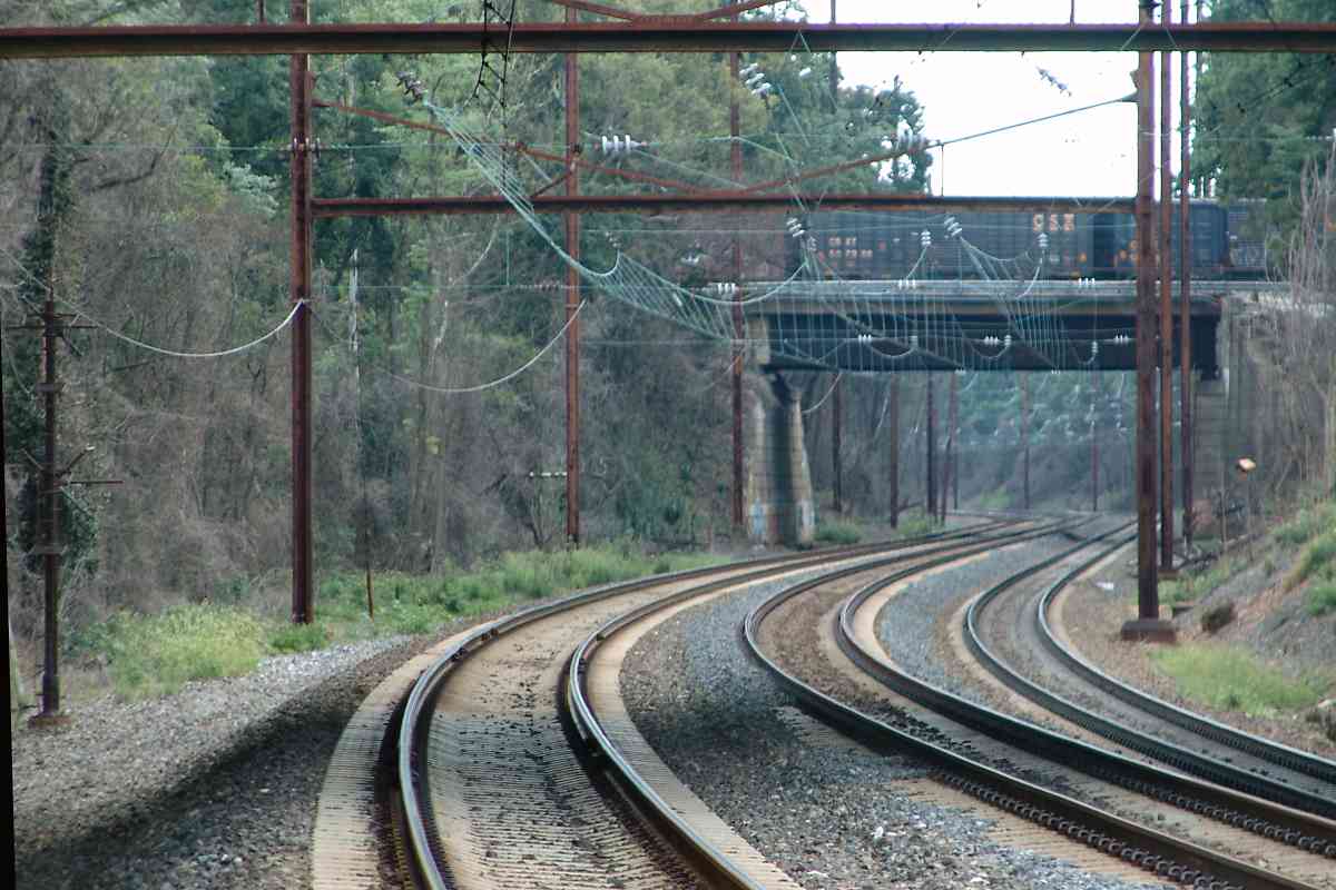
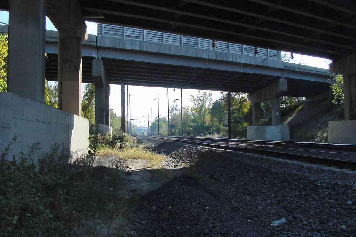
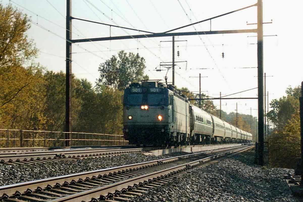
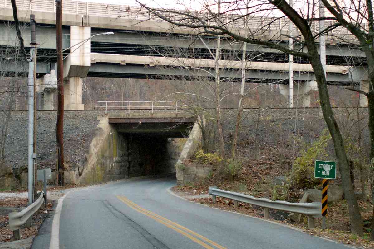
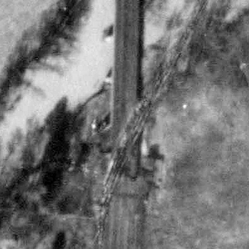
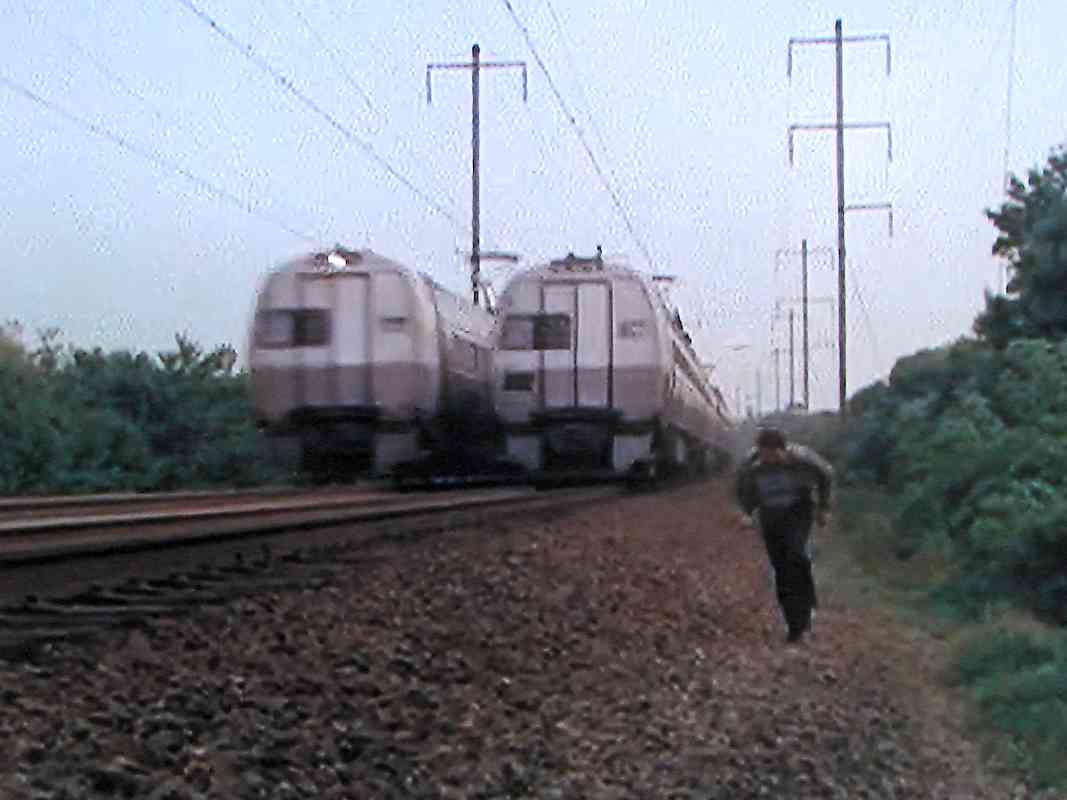
In this scene from the 1975 TV series Movin' On, Claude Akins (or his stunt double) as Sonny jumps from the Furnace Avenue bridge in an attempt to take back his truck from hijackers, one of whom is oblivious below. Sonny does not know his rig is carrying dangerous cargo.

Reader SFC Charles Thompson wrote:

    "Steve, I really enjoy your website. I am currently serving in Afghanistan, and between missions I like to go to your site on my down time, as it is like a short visit home.

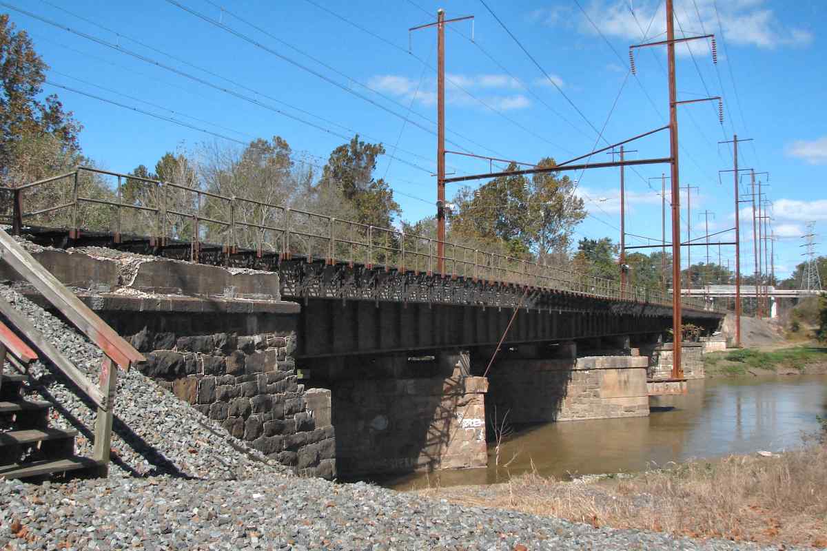
    "I do not know if many people are aware of this, but a small portion of the Pennsy, specifically the Furnace Ave. bridge, was featured in the TV show from 1975 called 'Moving On', Movin' On starring Claude Akins. The episode was #2 from season two, called 'From Baltimore to Eternity'. During the show the green semi 'Sonny' operated became stuck under the Furnace Ave. bridge. Claude's character, Sonny, climbed up onto the right of way to inspect the problem just as a Metroliner went past. Pretty dramatic footage to me at age 11. The bridge seemed remote to me, especially since this was before the construction of the I-195 spur to BWI. I don't know where to get a link to footage from the show, but it would be great for the Furnace Ave. bridge section."

As of this writing, Amazon Prime members can stream at no extra cost two seasons of the Movin' On series. The mentioned episode also contains on-location filming around Baltimore's Inner Harbor while its World Trade Center and Maryland Science Center were under construction.


MARC 7851
Photo courtesy Dave Hiteshew

MARC 7851
Mile: 104.9 Date: Oct 2009
Ease: A- View: NW
Area: B T6:
Map: AA 1 K 6 Topographic Maps

MARC 4912 pushes this commuter train past the site of Patapsco Station, a B&P original stop. What is likely the station building appears in a 1952 aerial, but now the site has merely a flat-graded area. A 1970 aerial shows a path of trash from the site north into the former quarry, which matches a report I received about parts of the demolished station being found there. That's I-195 above.


<< Previous (north) | THIS PAGE: Winans to Patapsco | Next (south) >>

Or, return to main page

Copyright Notice