TrainWeb.org Facebook Page
PRR / Amtrak Photo Tour


PRR / Amtrak in Maryland
Modern day photo tour

Accompanying each photo below are:

Click a photo to see a larger view. Please send your comments and corrections to Steve.


Special Note: >>> The places described on this page host quiet, high-speed trains. Stay well clear! <<<

<< Previous (northeast) | THIS PAGE: Loudon Park | Next (south) >>

Gwynn Tower

Gwynn Tower
Mile: 99.4 Date: Feb 2016
Ease: B View: E
Area: C- T6: 335
Map: Ba 42 E 1 Topographic Maps

tower closeup Gwynn Tower was initially named Gwynns Run Tower. Centralized traffic control spelled the end of PRR's towers, and Gwynn was no exception. It went disused during the 1980s, and has deteriorated since.

Building a B&P Tunnel replacement will bring big equipment to the area, making for a logical time to demolish the tower.

Links: 1977, 1980 pic with GG1, 1995, PRR tower list


MARC 4915

MARC 4915
Mile: 99.4 Date: Feb 2016
Ease: B View: SW
Area: C- T6:
Map: Ba 42 E 1 Topographic Maps

Immediately south of Gwynn Tower, eight signals, the most you'll find in one spot, regulate trains in two directions along four tracks. A fifth track was removed during 2012.

Link: 1957


Amtrak 2022
Photo courtesy Dave Hiteshew

Amtrak 2022
Mile: 99.9 Date: Oct 2007
Ease: B View: N
Area: C T6:
Map: Ba 42 C 2 Topographic Maps

The previously-mentioned fifth track is visible at right in this older view under Frederick Road.


Aerial 1927
Photo courtesy Johns Hopkins University

Aerial 1927
Mile: 100 Date: 1927
Ease: View: S (up)
Area: T6: 337
Map: Ba 42 C 2 Topographic Maps

Note that north is at the bottom of this photo, where one finds Frederick Road with Caton Avenue meeting it at lower left. By photo time, quad track, or at least room for such, had reached this far, hindered from further progress by not only the Frederick Road bridge but also a B&P station. The white arrow points to B&P's Carroll Station, later Frederick Road Station, that nestled at the intersection. PRR removed the station during 1930 so quad tracking could continue south.


Aerial 1967
Photo courtesy Library of Congress

Aerial 1967
Mile: 100 Date: 1967
Ease: View: S (up)
Area: T6:
Map: Ba 42 C 2 Topographic Maps

"Sta" marks the site of the original station. A Wikipedia reference claims a subsequent station building remained in use by Amtrak until 1984, but the latest I could confirm from a train schedule was 1971. The white arrow points to what might have served as the station at the time of this photo. The wye at photo top shows where the Claremont Branch met the main. Loudon Park Cemetery is on the right.


Sidings
Photo courtesy Dave Hiteshew

Sidings
Mile: 100.0 Date: Oct 2007
Ease: B View: N
Area: C T6: 337
Map: Ba 42 C 2 Topographic Maps

That fifth track had connected to these assorted industrial sidings south of Frederick Road. The B&P's/PB&W's/PRR's original station here (Carroll Station) had been located on this side of the bridge, left of the green trees left of photo center.


Amtrak 2011
Photo courtesy Dave Hiteshew

Amtrak 2011
Mile: 100.0 Date: Oct 2007
Ease: B View: S
Area: C T6:
Map: Ba 42 C 2 Topographic Maps

Via a wye on the left the extra track also connected to the Claremont Branch that served stockyards between the Penn Line and B&O's Old Main Line. The stockyard slogan was "Every hoof under one roof."


Guard Rail
Photos courtesy Dave Hiteshew

Guard Rail
Mile: 100.0 Date: Oct 2007
Ease: B View: E
Area: C T6:
Map: Ba 42 C 2 Topographic Maps

1915 The Claremont Branch opened in 1892 and, due to a decline in use after the mid-20th Century, preserved some older examples of track equipment, such as these dated 1915 and 1925.

"Manganese Guard Rail 1925 Manufacture Type N" - Manganese added to the steel created a harder, tougher material better able to withstand impacts. It was, and still is, often used for rail frogs. Guard rails were likely used here to reduce the chance a train would derail and spill onto the adjacent, active, high-speed tracks.


Amtrak 917

Amtrak 917
Mile: 100.0 Date: Jul 2015
Ease: B View: N
Area: C T6: 338
Map: Ba 42 C 2 Topographic Maps

All that old trackage was cleaned out by the time of this photo at milepost 100. Amtrak would retire this and all its AEM-7 locomotives within the year that followed.

The AEM-7s had in 1980 replaced Amtrak's ex-PRR GG1s. During 1935 PRR GG1s 4800 and 4880 had made the inaugural trip along the then-newly-electrified route between New York City and Washington.

Link: pic of GG1 number 4800


Milepost 100

Milepost 100
Mile: 100.0 Date: Jul 2015
Ease: B View: W
Area: C T6:
Map: Ba 42 C 2 Topographic Maps

This spot near St. Agnes Hospital is 100 railroad miles from PRR's Broad Street Station in Philadelphia, Pennsylvania.


Amtrak 2024

Amtrak 2024
Mile: 100.1 Date: Jul 2018
Ease: B View: NE
Area: C T6:
Map: Ba 42 C 2 Topographic Maps

At photo time, Acela units such as AMTK 2024 still had a decade or two of useful life. Actively used motive passenger rail equipment generally lasts 30 to 40 years. Rail equipment made by one particular manufacturer, Budd, has often lasted 50 years.

During 2018 Amtrak fenced off the Claremont Branch wye on the right.

Change for: Claremont Branch tour at this site


Amtrak 650
Photo courtesy Dave Hiteshew

Amtrak 650
Mile: 100.2 Date: Oct 2007
Ease: A- View: N
Area: C T6:
Map: Ba 42 C 2 Topographic Maps

On a fine autumn day AMTK 650 nears the site of Loudon Park Station, and Loudon Park Cemetery. Serious railfans in their own autumn need look no further for a burial spot with a good view.


Loudon Park Station

Loudon Park Station
Mile: 100.2 Date: 1927
Ease: View: N (up)
Area: T6: 337
Map: Ba 42 C 2 Topographic Maps

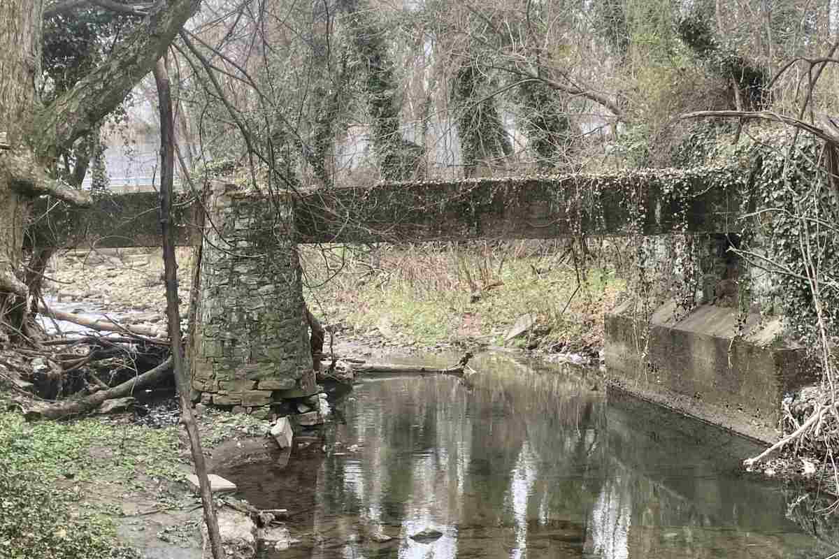
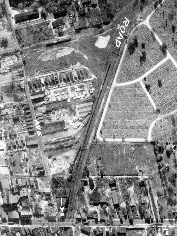
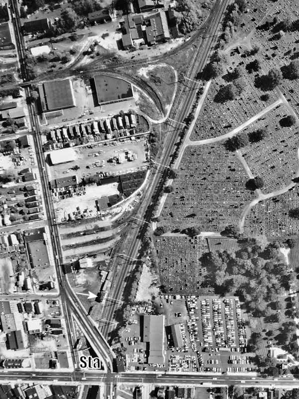
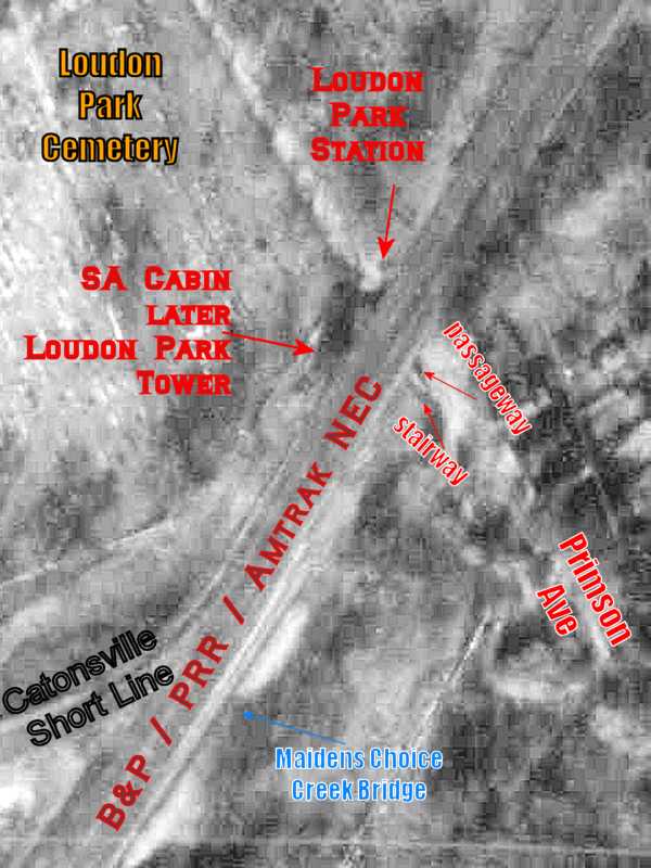
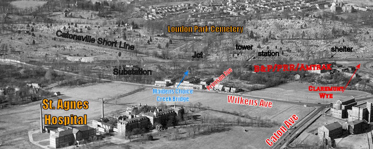
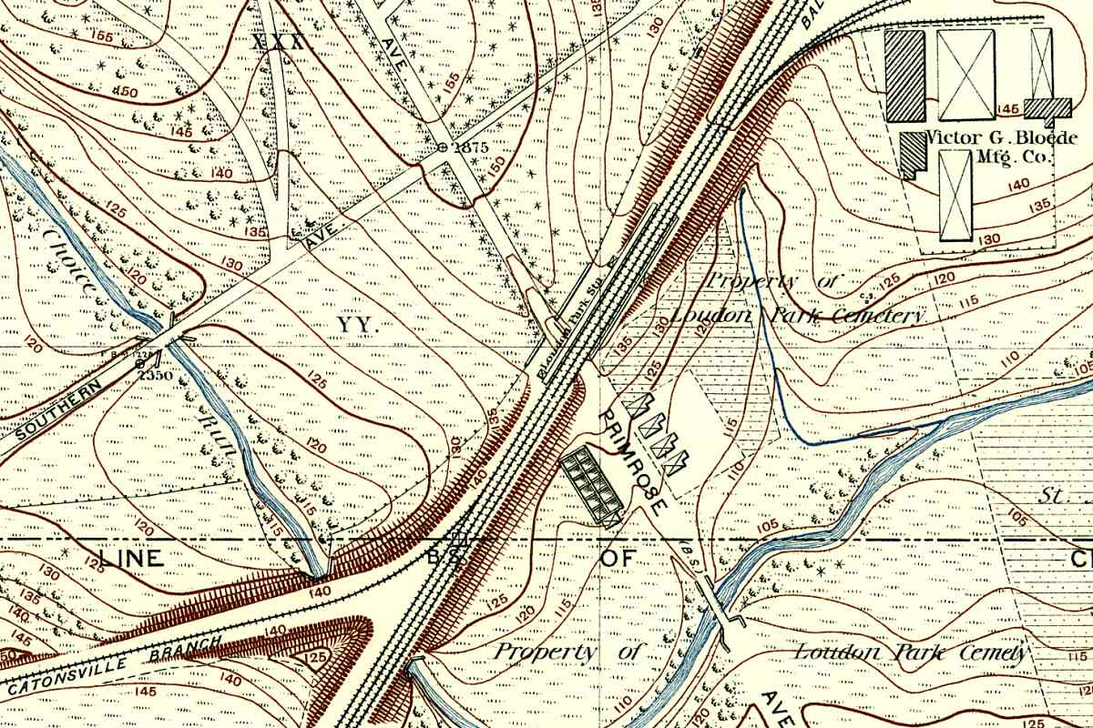
Loudon Park Station was one of three B&P structures on the northwest side of the main line tracks between the Claremont Branch and Catonsville Short Line (CSL), a Class III railroad that served Catonsville, Maryland. Though the CSL ceased operation during 1972, enough artifacts are found to warrant its own tour pages.

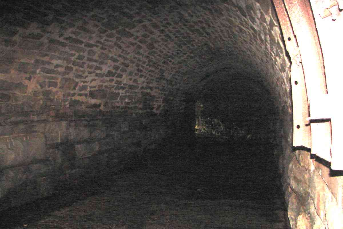
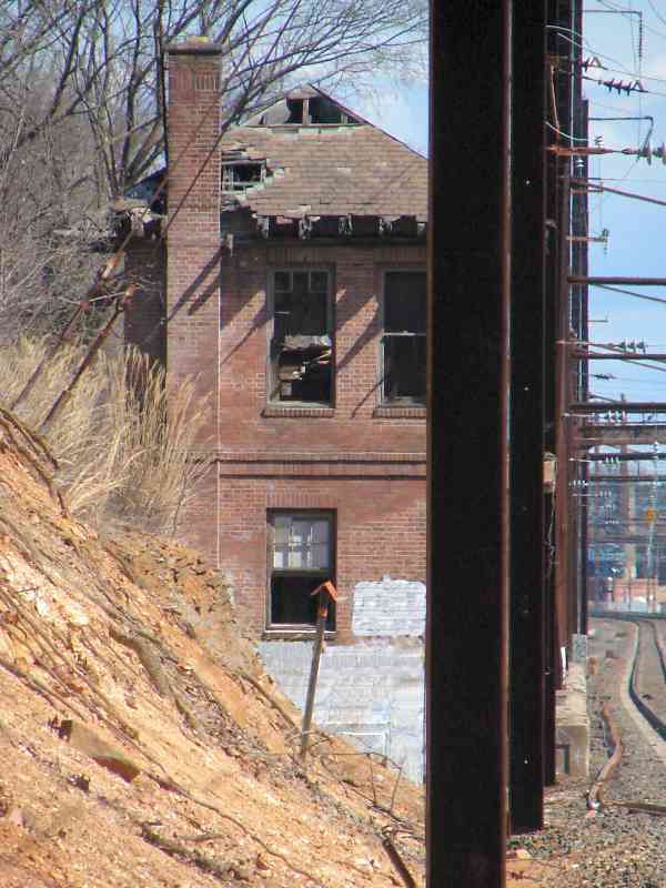
The largest structure was SA Cabin, later named Loudon Park Tower, southwest of a passageway under the tracks that connected Primson Avenue with the cemetery. Loudon Park Station, little more than a waiting shack, sat north of the passageway.

Polk's Baltimore Maryland City business directory of 1906 reports, "LOUDON PARK STATION (B&P RR), SE side of Loudon Park Cemetery." The B&P name hung on after it was incorporated into the Philadelphia, Wilmington & Baltimore Railroad during 1902. Remember, these were little more than names since both companies were under control of PRR.


Artifacts

Artifacts
Mile: 100.2 Date: Oct 2016
Ease: A- View: S
Area: B- T6: 338
Map: Ba 42 C 2 Topographic Maps

These cut stones are likely remnants of Loudon Park Station's foundation, platform, or stairs. In the cemetery a path of slate pavers leads to this location, but during 2018 Amtrak added fences that block your way to the tracks. The dark red utility box occupies the site of Loudon Park Tower. Between the station and tower is the passageway under the tracks. Aerial photos indicate decreasing use of the passage, as evidenced by increasing plant growth, starting during the 1960s.


Passageway

Passageway
Mile: 100.2 Date: Oct 2016
Ease: B View: SE
Area: C+ T6:
Map: Ba 42 C 2 Topographic Maps

The passageway looks surprisingly modern, lined with concrete rather than cut stone. This was a logical place for the CSL and B&P to exchange passengers not only because it is where the two lines met but also because from here people could access both St. Agnes Hospital and Loudon Park Cemetery. Primrose Avenue had connected with the passageway.


1939 Aerial
Photo courtesy Baltimore Sun

1939 Aerial
Mile: 100.3 Date: 1939
Ease: View: W
Area: T6: 338
Map: Ba 42 E 4 Topographic Maps

At first glance, this 1939 aerial photo by The Baltimore Sun newspaper appears ready to help, but unfortunately is too low a resolution for us to pick out small trackside structures.

A 1945 Pennsylvania RR list of the Maryland Division confirms Loudon Park Station was located between the Claremont Branch and the CSL junction:

  • Jct. B. & O. R. R. / Baltimore MD / PRR / Interchange / Claremont Branch - 8692
  • Station / Loudon Park MD / PRR / Main Line - 8750
  • Jct. C. S. L. R. R. / Loudon Park MD / PRR / Main Line - 8750
    • Public Delivery / Kenwood MD / PRR / R Freight - All Kinds / Catonsville Short Line Railroad - 8754
    • Public Delivery / State Asylum MD / PRR / R Freight - All Kinds / Catonsville Short Line Railroad - 8756
    • Spring Grove State Hospital / State Asylum MD / PRR / Catonsville Short Line Railroad - 8756
    • J. S. Wilson Co. / Catonsville MD / PRR / Catonsville Short Line Railroad - CV
    • Public Delivery / Catonsville MD / PRR / Catonsville Short Line Railroad - CV
    • End of Catonsville Short Line Railroad / Catonsville MD / PRR / Catonsville Short Line Railroad - CV

Link: source photo


Start

Start
Mile: 100.3 Date: Aug 2015
Ease: B View: SW
Area: B- T6: 339
Map: Ba 42 C 3 Topographic Maps

Even if the stations and stops are inscrutable, the CSL itself is more evident. As seen from the tuscan red equipment box, the vague gap in the trees right of the boulder reveals where the CSL had ventured. At the right edge of the photo the weeds diminish because Maidens Choice Creek flows below.

Bloede Mfg Co 1894 The boulder serves no railroad purpose but rests where an 1895 topographical map (left) says an old Baltimore City boundary stone (B.S.) was placed. This was the city's limit after the so-called Belt Annexation of 1888 moved the city's southwest corner to within Loudon Park Cemetery a half mile west of this boulder. Baltimore City would expand to its current (2019) size in 1918.

Change for: Catonsville Short Line tour at this site


Stone Bridge

Stone Bridge
Mile: 100.3 Date: Aug 2015
Ease: B+ View: SE
Area: B T6:
Map: Ba 42 C 3 Topographic Maps

Unlike B&O's Old Main Line, few original stone arch bridges survive along the Pennsylvania RR's line through central Maryland. This one has been modified multiple times, first widened with stone to support the CSL, and later with concrete to shore up weaknesses.


Interior

Interior
Mile: 100.3 Date: Aug 2015
Ease: B View: E
Area: B- T6:
Map: Ba 42 C 3 Topographic Maps

The interior's dog leg and masonry products reveal the extent of modifications during the bridge's more-than-150-year life.


AC Motor Stop
Photos courtesy Dave Hiteshew

AC Motor Stop
Mile: 100.3 Date: Oct 2007
Ease: B View: SW
Area: C T6:
Map: Ba 42 C 3 Topographic Maps

AC Motor Stop 55 speed A.C. Motor Stop signs are posted where the catenary ends for a given track. The drilled "pixels" endure in a way paint does not.

Some much newer signs, such as the speed 55 at right, emulate the drilled style only in appearance.


Amtrak 625

Amtrak 625
Mile: 100.3 Date: Sep 2015
Ease: B View: S
Area: B- T6:
Map: Ba 42 C 2 Topographic Maps

AMTK 625 model ACS-64 speeds past the Loudon Park Substation; some PRR documents spell it Louden Park. This location, also known as Violetville, has long been associated with electricity: in the vicinity were offices of Victor G. Bloede, the person who financed Bloede Dam as part of the Patapsco Electric & Manufacturing Company.

Visually behind the train is the Violetville Substation that took the place of B&P's St. Agnes Station.

Links: 1932, 1970s LoC photo, more about Victor G. Bloede


1882_map
Updated late-Aug 2022

1882 Map
Mile: 100 Date: 1882
Ease: View: N (up)
Area: T6:
Map: Ba 42 C 2 Topographic Maps

St. Agnes Station had also been known as Maidens Choice Station. Per an 1898 atlas, the station was located in the northeast quadrant of Maidens Choice Road's grade crossing with B&P. Grade separation came during the late 1800s when Wilkens Avenue was built on a new alignment adjacent to Maidens Choice Road. Wilkens met the old alignment immediately east of Caton Avenue which is why even now it curves abruptly there.

Perhaps due to property or grading problems, the CSL met B&P a short distance northeast of B&P's St. Agnes Station. The resulting inconvenience to passengers was one reason St. Agnes Station was replaced by Loudon Park Station nearer CSL Junction.

During years following this map, Joseph Brinkley's property would be added to Loudon Park Cemetery, and Maidens Choice Road south of the cemetery would be erased, its traffic shifted to the newer and straighter Wilkens Avenue.


Saint Agnes Station
Updated late-Aug 2022

Saint Agnes Station
Mile: 100.4 Date: 1927
Ease: View: N (up)
Area: T6: 337
Map: Ba 42 C 3 Topographic Maps

This aerial view suggests St. Agnes Station was still standing as of 1927. One source reports it was disused as a station during 1885 having been bypassed around that time by the then-new Wilkens Avenue. Passengers instead used Loudon Park Station about 1200 feet northeast at CSL Junction. The dashed red line traces for former Maidens Choice Road.

A few years after this photo, electricity came to the railroad, prompting the site of St. Agnes Station to be repurposed into Violetville Substation.


MARC 33

MARC 33
Mile: 100.3 Date: Aug 2015
Ease: B View: S
Area: B- T6:
Map: Ba 42 C 3 Topographic Maps

Occasionally you'll see a mashup of MARC (Maryland Area Regional Commuter) equipment like this: two engines of different designs hauling a mix of bi-level and single-level cars. One standard is the frontmost car is always a quiet car intended for passengers to read, relax, or work rather than talk.

The portion of the Northeast Corridor covered by this tour is known as the Penn Line to the commuters aboard this train. In the background is an overpass carrying Wilkens Avenue.


<< Previous (northeast) | THIS PAGE: Loudon Park | Next (south) >>

Or, return to main page

Copyright Notice