TrainWeb.org Facebook Page
PRR / Amtrak Photo Tour


PRR / Amtrak in Maryland
Modern day photo tour

Accompanying each photo below are:

Click a photo to see a larger view. Please send your comments and corrections to Steve.


Special Note: >>> The places described on this page host quiet, high-speed trains. Stay well clear! <<<

<< Previous (north) | THIS PAGE: Glenn Dale to New Carrollton | Next (south) >>

A16505

A16505
Mile: 120.9 Date: Mar 2019
Ease: A View: SE
Area: B+ T6:
Map: PG 9 G 8 Topographic Maps

What was Herbert Hoover's campaign slogan? "A chicken in every pot, and a train in every photo," something like that. This tour page gets close to that goal, plus, unlike President Hoover, can guarantee the value of your Pennsylvania RR stock will not collapse.

During 2019 this Catenary Maintenance Vehicle was kept busy installing new power cable hangers above track 1. Note the European-style bumpers.


Amtrak 2036

Amtrak 2036
Mile: 121.4 Date: Mar 2019
Ease: B- View: NE
Area: B+ T6:
Map: PG 9 F 8 Topographic Maps

Keeping a safe distance often means deep zoom (36x) photos that exhibit heat distortion even on cool March days. Let's call it an artistic effect.

The zoom reveals Bowie sits at a lower elevation than its surroundings. That's the museum's yellow caboose at distant right.

Link: 1977


Newstop Branch

Newstop Branch
Mile: 121.4 Date: Mar 2019
Ease: B View: NW
Area: A T6:
Map: PG 9 F 8 Topographic Maps

Stone culvert hunting along the Penn Line often disappoints with modern piped culverts. This one's outlet is surprisingly distant from the trains, perhaps to facilitate future track additions. Some maps list this creek as the Newstep Branch.


Amtrak 2002

Amtrak 2002
Mile: 121.9 Date: Apr 2004
Ease: A View: NE
Area: A- T6:
Map: PG 9 E 9 Topographic Maps

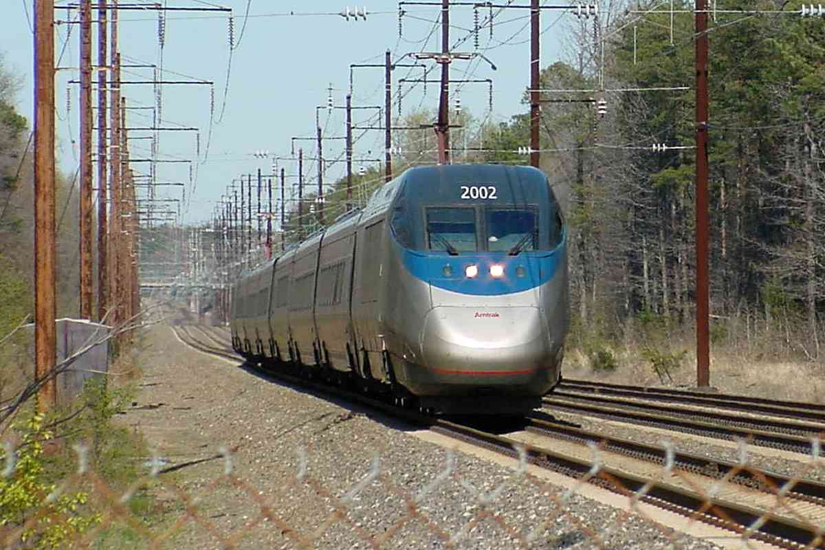
Enduring almost till 1990, Springfield Road, the last grade crossing to be eliminated on the Northeast Corridor between Washington, DC and New York, provided a nice spot to watch AMTK 2002 zoom past. Since photo time the fencing has changed. A 1904 map places Springfield Station within the southeast quadrant of the crossing.

This is the first known photo of Acela power car number 2002. Due to various problems, the Acela units replaced Amtrak's Metroliners more slowly than initially anticipated. Metroliner service endured until 2006.

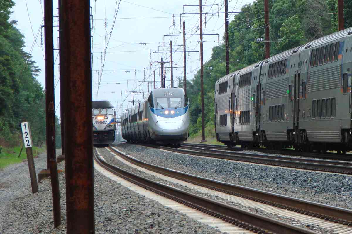
Per local resident Derald, as confirmed by topo maps, during its 1930s electrification this stretch of the line was shifted southeast (right) into the position seen here. The original route is buried in Derald's yard.


Two Trains

Two Trains
Mile: 121.9 Date: Jun 2018
Ease: B View: NE
Area: A- T6:
Map: PG 9 E 9 Topographic Maps

One photo, two moving trains.


Three Trains

Three Trains
Mile: 121.9 Date: Jun 2018
Ease: B View: SW
Area: A- T6:
Map: PG 9 E 9 Topographic Maps

One photo, three moving trains. Topping that along a high-speed line will be difficult, even after a fourth track is added.


Amtrak 651

Amtrak 651
Mile: 122.1 Date: Jun 2018
Ease: B View: SW
Area: A- T6:
Map: PG 9 E 10 Topographic Maps

Northbound AMTK 651 has just passed the line's highest spot in PG County.


Quiet Spur

Quiet Spur
Mile: 122.6 Date: Jun 2018
Ease: A View: NE
Area: B T6:
Map: PG 9 C 11 Topographic Maps

In Glenn Dale, the line's only in-service industrial spur bewteen Odenton and Landover has been quiet for awhile.

On the way to Washington during the 1830s, B&O chose to build near the fall line ostensibly because that was the location favored by water-powered factories, ones that, along with their employees, could become rail customers. With more luck than foresight, during the 1870s the B&P/PRR built east of the fall line, a fortuitous choice that later enabled the railroad to serve the next generation of businesses, ones powered by electricity and located near US 1 / I-95. The fall line represents approximately how far inland the ocean reached the last time all of Earth's ice melted.


Amtrak 2027

Amtrak 2027
Mile: 123.1 Date: Apr 2019
Ease: B View: SW
Area: A T6:
Map: PG 9 B 11 Topographic Maps

1878 map An 1878 Hopkins map places the B&P station in the northeast quadrant of the (former) grade crossing with Glenn Dale Road; in the main photo that's on the left.

As of 2019 St. George's Episcopal Church was still at the location shown on the 1878 map, but a proposed Maglev train route squeezes close to it. A 1904 map labels the area on the southeast side as an estate of Ex-Governor Oden Bowie.

Links, before grade separation: 1971, 1971


Retaining Wall

Retaining Wall
Mile: 123.4 Date: Apr 2019
Ease: B View: SW
Area: A- T6:
Map: PG 9 B 11 Topographic Maps

Folly Branch meanders and erodes enough in this vicinity to require a railroad retaining wall for AMTK 654 and relatives.


MARC 19

MARC 19
Mile: 123.9 Date: Apr 2019
Ease: B View: NW
Area: A T6:
Map: PG 8 K 12 Topographic Maps

When one looks up prosaic in a railroad dictionary, pictured is a modern piped culvert. Perhaps this one will be interesting a century from now, or maybe not. In either case, it is hereby documented. The opposite (inlet) end is equally modern concrete and pipe.

To the southwest, and accessible only by railroad, a 1904 map labels an apparent housing development named Brashears Park. Perhaps the plan never came to fruition because no traces of it remain evident.


New Attachments

New Attachments
Mile: 124.0 Date: Apr 2019
Ease: B View: SW
Area: A- T6:
Map: PG 8 K 12 Topographic Maps

new mount During 2019 Amtrak equipped track 1 with new catenary holder arms between what are known as the messenger and the auxiliary wires. These arms will dampen destructive oscillating waves that higher speed trains can induce in the wires. The bronze auxiliary and copper contact wires are grooved to facilitate attachment grasp.

This is preparation for higher speed operation. Amtrak made test runs of Acela equipment up to 165 mph during 2012.

Unfortunately, the arms add visual clutter to an already visually busy system. These holders will presumabely be added to the catenary above the other two tracks as well.


Misty

Misty
Mile: 124.6 Date: Jun 2018
Ease: A- View: NE
Area: A- T6: 389
Map: PG 8 J 13 Topographic Maps

A misty afternoon helps us briefly imagine that's the headlight of a Pennsy K4 steamer slowing to stop at Seabrook, even when in reality it's another MARC train.

The large black rectangles at track level are defect detectors. Sometimes they are called smashboards, though the first smashboards were devices used at bridges to warn the operator of impending danger. Something being dragged by a train will strike a defect detctor's paddle, and trigger an alert to the railroad.

Links: CR 807, snowing, CSX 809


Amtrak 629

Amtrak 629
Mile: 124.6 Date: Aug 2019
Ease: A- View: NE
Area: A- T6: 389
Map: PG 8 J 13 Topographic Maps

On a clear day you can see forever -- or AMTK 629 -- whichever comes first.

The distance of viewable straight trackage is at least 2 miles, on a clear day.

Links: NS 4270, CSX 5103


Seabrook Station

Seabrook Station
Mile: 124.6 Date: Aug 2019
Ease: A- View: SW
Area: A- T6:
Map: PG 8 J 13 Topographic Maps

Seabrook is the only location in PG County that's enjoyed regular train service continuously since 1872. The B&P's station building had stood on the southeast side of the tracks (left).

The end of this train would be crossing Seabrook Road had not Amtrak closed the grade crossing circa 1990. For commuters, MARC built longer platforms and moved the nearby signals about 1000 feet northeast of the location seen in the various linked 1960s photos. A commuter train crashed into a stalled Amtrak train here on June 9, 1978.

Link: NTSB warns of faulty cab signals


MARC 26

MARC 26
Mile: 124.7 Date: Jun 2018
Ease: A- View: SW
Area: A- T6:
Map: PG 8 J 13 Topographic Maps

Rain-spattered MARC 26, trying to find the sun, pushes away from Seabrook.

A freight siding had served businesses on the northwest (right) side of the tracks during prior decades.

Links looking SW: 1968, PC 4906 at grade crossing 1969, 1978


Penn Central 4900
Photo credit Roger Puta

Penn Central 4900
Mile: 124.8 Date: Mar 1969
Ease: A- View: NE
Area: A- T6:
Map: PG 8 J 13 Topographic Maps

Before MARC and Amtrak were conjured, short-lived Penn Central hauled freight along the line such as via this 1940-built ex-PRR GG1 class locomotive. The photographer is looking northeast from Seabrook Road's former grade crossing.

PC retained PRR's single-color Position Light signals; Amtrak would colorize them later, plus add gauntlet signals as seen in the 1978 photo linked below. Gauntlet signals, the small circles next to the larger position light signals, alerted train operators to gauntlet track switch settings. The gauntlet track added after this photo would bring stopping trains closer to station platforms. Apparently, the extra gauntlet switches and signals were deemed unnecessary, because they are no longer extant, likely removed about 1990.

Links: source photo, 1978, PRR 4900, PC 4900, as AMTK 903


Bald Hill Branch

Bald Hill Branch
Mile: 125.3 Date: Apr 2019
Ease: B+ View: S
Area: A- T6:
Map: PG 13 G 1 Topographic Maps

van Every so often my opsimathy for the B&P is rewarded by an artifact such as this fine stone bridge over Bald Hill Branch. It is visible from Lanham Severn Road. Relatively fresh mortar suggests it has been rebuilt since its B&P origin, but that's not a complaint. The other, outlet side looks to be concrete, probably the result of lengthening to permit more tracks above, however that side is difficult to access for a photo. The white van was hauling track workers.

Unless I've missed another, only three B&P stone arch bridges survive along the Penn Line: this one, Severn Run, and Maiden's Choice.


Amtrak 2003

Amtrak 2003
Mile: 125.7 Date: Aug 2019
Ease: B+ View: NE
Area: B T6:
Map: PG 13 F 2 Topographic Maps

After several miles of straight track, DC-bound AMTK 2003 demonstrates it remembers how to negotiate curves such as this one near Lanham.


MARC 32

MARC 32
Mile: 126.1 Date: May 2019
Ease: B+ View: W
Area: B T6:
Map: PG 13 F 3 Topographic Maps

As seen from the Lanham Station Road grade crossing (now closed), MARC 32 with "steam" breaking on its brow lifts passengers up a gradual incline. The railroad generally follows the Beaver Dam Branch southwest from here to the Anacostia River. That's the I-95/I-495/Capital Beltway in the background.

The next photo illustrates the reverse view as would be seen from the white truck traversing the Beltway.


From Beltway

From Beltway
Mile: 126.3 Date: Dec 2018
Ease: A View: E
Area: B T6:
Map: PG 13 E 3 Topographic Maps

The B&P's Lanham Station had stood at bottom right, on the other side of the tracks within the southeast quadrant of the Lanham Station Road grade crossing. MARC service continued there until 1982, long after the station structure had been removed.


Capital Beltway
Photo credit Hikki Nagasaki

Capital Beltway
Mile: 126.5 Date: Jun 1979
Ease: C View: NE
Area: B+ T6:
Map: PG 13 E 4 Topographic Maps

Dating to 1970, Capital Beltway Metropark was the last station planned by PRR; it opened under the name of successor Penn Central. It was an infill station designed for easy automobile access from the Capital Beltway. Three months and five days after the station opened, Penn Central declared bankruptcy; in 1971 control of the station was turned over to Amtrak. Conrail operated PRR's commuter trains from then until Maryland took over.

During 1982, MDOT (later MARC) ceased commuter service at both Lanham and Landover in favor of Capital Beltway, thereby overloading it. Fortunately, a larger station was already under construction nearby, adjacent Washington Metro's New Carrollton stop. When in 1983 MARC began stopping at New Carrollton, the Capital Beltway station was shuttered.

Links: about station, 1973, 1976


Gauntlet Signal
Photo credit Roger Puta

Gauntlet Signal
Mile: 126.5 Date: Jul 1970
Ease: C View: SW
Area: B+ T6:
Map: PG 13 E 4 Topographic Maps

Concern about high speed trains running adjacent to, but not stopping at, the Capital Beltway's platform led to the addition of gauntlet track, the nearer set of rails seen in this photo, as at Seabrook. Gauntlet signals, the small circles next to the larger position light signals, alerted train operators to the switch settings.

Penn Central would never get around to repainting all its old PRR equipment, hence the leftover red and gold Pennsy keystone heralds on these MP54 units. The company had filed for bankruptcy a few weeks before this photo.

MP54s came in several varieties, the first of which entered service during 1908. Such "red cars" or "red rattlers" were a familiar sight to commuters in various Northeastern US cities until the last car was retired in 1981. Several examples survive in museum collections.

Links: 1970, 1970s


Station 1972
Photo credit Hikki Nagasaki

Station 1972
Mile: 126.5 Date: Apr 1972
Ease: A View: NW
Area: B+ T6:
Map: PG 13 E 4 Topographic Maps

The addition of commuter service during 1982 overwhelmed the tiny "Capital Beltway Transportation Center" that offered seating to just 10 waiting passengers. The station operated from March 16, 1970 to October 30, 1983.

Link: source photo


Ex-Station 2019

Ex-Station 2019
Mile: 126.5 Date: Jun 2019
Ease: A View: NW
Area: B+ T6:
Map: PG 13 E 4 Topographic Maps

With extensive remodeling the station found a new life as an office. At least they retained, the, umm, front door, maybe.

A now disused and sealed passenger passageway runs under the tracks.

Link: more about station


New Carrollton

New Carrollton
Mile: 126.9 Date: Jun 2018
Ease: A View: NE
Area: B T6:
Map: PG 13 D 5 Topographic Maps

The aforementioned Capital Beltway station was at distant center, this side of the visible overpass, which is the Beltway. Since 1978 Metro's New Carrollton yard and repair shops have been at right.

New Carrollton has blossomed into a transportation center to rival DC's Union Station. Metro, MARC, and Amtrak all stop here, as will light rail trains of the Purple Line under construction at photo time.

Links: 2010, 2010


Signals

Signals
Mile: 126.9 Date: Jun 2018
Ease: A View: NE
Area: B T6:
Map: PG 13 D 5 Topographic Maps

limited clear In the main photo's deep zoom, a northbound Amtrak train is changing tracks after passing a pole-mounted signal, one of only two along the Penn Line between Baltimore and DC. The pole signal is displaying Rule 281c, Limited Clear at what is named Carroll interlocking.

The wide area between tracks previously hosted one platform of Capital Beltway Station.

At left an approaching southbound MARC train is slowing to stop.

Links: 1979, rule 281c limited clear, CR 3253 at Carroll interlocking


Metroview

Metroview
Mile: 127.0 Date: Jun 2018
Ease: A View: W
Area: B T6:
Map: PG 13 D 5 Topographic Maps

If you gild it, they will come. Large office buildings and fancy mixed-use MARC 86 developments, such as Metroview, have sprung up around the busy station.

At photo time, MARC 86 had not yet celebrated its first birthday. If the Siemens Charger model SC-44 looks longer than all other MARC engines, that's because at 71 feet 4 inches it is. Amtrak also has some Chargers, that as of this writing it operates along the US west coast. The SC-44 can reach speeds in excess of 130 mph.


Entrance

Entrance
Mile: 127.0 Date: Jun 2019
Ease: A- View: W
Area: B+ T6:
Map: PG 13 D 5 Topographic Maps

While the trains make electric music, solid walls of concrete grace a station entrance that manages to look sleek.

New Carrollton's proximity to both the Capital Beltway and US 50 is one reason for its popularity. There were no transportation facilities at this site Before Metro opened here during 1978, though the Penn Line's old Lanham and Landover stations, plus the Capital Beltway stop, were not far.

Link: Metro under construction


Interior

Interior
Mile: 127.1 Date: Jun 2018
Ease: B+ View: W
Area: B+ T6:
Map: PG 13 D 5 Topographic Maps

Burnt orange was a popular color when Metro was getting going. New Carrollton's well-maintained station is older than it looks.

Link: more station pics


Ballast Train
Photo courtesy Dave Hiteshew

Ballast Train
Mile: 127.0 Date: May 2010
Ease: B+ View: NE
Area: B+ T6:
Map: PG 13 D 5 Topographic Maps

It takes a bit of luck to see more than just passenger trains operating along the Penn Line during the day. The Norfolk Southern engine within this consist is behind empty hoppers, and ahead of full ones. HZGX is the reporting mark of Herzog Contracting Corporation who would appear to have been actively reballasting this stretch of track at photo time.

The solar panels on top do not power the hoppers' movement but rather the doors at their botton that dispense fresh stone ballast. The link below is to a 4-second video of ballast pouring from a similar hopper along CSX's Old Main Line during April 2014.

Link: ballasting video (MPG format)


Amtrak 650
Photos courtesy Dave Hiteshew

Amtrak 650
Mile: 127.1 Date: May 2010
Ease: B+ View: NE
Area: B+ T6:
Map: PG 13 D 5 Topographic Maps

ACS-64 650 Since photo time, Amtrak's HHP-8 model units have been retired, but before that happened delivery of ACS-64 units began -- including, oops, some with the same numbers. Unit 650 shown above was later renumbered 680 to avoid confusion with the newer 650 at right.

A side note: ACS-64 units numbered 665 and 667 exist, but 666 was skipped.

Detour: this site's Amtrak ACS-64 photo page


Amtrak 914
Photos courtesy Dave Hiteshew

Amtrak 914
Mile: 127.1 Date: May 2010
Ease: B+ View: SW
Area: B+ T6:
Map: PG 13 D 5 Topographic Maps

By photo, time Amtrak's boxy AEM-7 "toasters" such as AMTK 914 were pantograph nearing retirement. However, many of the round-sided Amfleet cars like these, some dating to the 1970s, were still rolling as of 2019 having been refurbished during 2017. Amfleet cars are modeled on the Penn Central's Metroliner cars of 1969.

To reach up and touch the overhead electric supply line, Amtrak's preferred pantograph design has settled on the flexing arm and contact seen at right. I am surprised the "ears" at its top sides curve downward since an upward curve would better discourage the mechanism from sliding to the side then up over the catenary, which would be Not Good.


MARC 8054

MARC 8054
Mile: 127.1 Date: Jun 2019
Ease: B+ View: E
Area: B+ T6:
Map: PG 13 D 5 Topographic Maps

Two of these (insulated?) catenary pole crossbars are found at the station.

Link: similar view from ground 1977


Take Your Pick

Take Your Pick
Mile: 127.1 Date: Jun 2019
Ease: B+ View: S
Area: B+ T6:
Map: PG 13 D 5 Topographic Maps

From left to right at New Carollton: Metro (Orange Line), Amtrak, MARC. The Purple Line will be another option; the line's other end is in Bethesda at Metro's Red Line. Compared to Baltimore, the DC region is better at interconnecting disparate transportation types.

Links: ~1978, ~1980, ~1980


Amtrak Leading MARC

Amtrak Leading MARC
Mile: 127.2 Date: Jun 2019
Ease: B+ View: SW
Area: B+ T6:
Map: PG 13 D 5 Topographic Maps

These are not round-sided Amfleet cars. Instead, here AMTK 631 leads a set of MARC bi-level cars on what was announced as a MARC train. In 2019 MARC arranged to borrow a limited amount of Amtrak equipment during rush hours.

All the cantilevered signal mounts along the Penn Line are near stations, however this is the only one holding one full-sized signal.

Links: 1987, Amtrak Archives Northeast 1980s


Departures
Photo courtesy Dave Hiteshew

Departures
Mile: 127.2 Date: May 2010
Ease: B+ View: SW
Area: B+ T6:
Map: PG 13 D 5 Topographic Maps

Yes, these two Washington-bound trains are going bye bye, but do not despair, trains less camera-shy will appear in the next update.

Link: ~1980 similar view pre-station


<< Previous (branch) | THIS PAGE: Glenn Dale to New Carrollton | Next (south) >>

Or, return to main page

Copyright Notice