TrainWeb.org Facebook Page
PRR / Amtrak Photo Tour


PRR / Amtrak in Maryland
Modern day photo tour

Accompanying each photo below are:

Click a photo to see a larger view. Please send your comments and corrections to Steve.


<< Previous (index) | THIS PAGE: Susquehanna to Martin Airport | Next (southwest) >>

Special Note and Brief Historical Background:

Susquehanna River
Photos courtesy Dave Hiteshew

Susquehanna River
Mile: 60.5 Date: Oct 2007
Ease: B View: SE
Area: A T6:
Map: Harford County Topographic Maps

From below, fishermen watch a northbound train cross the ex-Pennsylvania Railroad, now Amtrak, Susquehanna River bridge. It is the oldest fishing of five extant bridges that span the river within Maryland, as well as the shortest and farthest downstream of the five, located near where ferry service began during the 1600s to connect Perryville with what is now Havre de Grace, Maryland.

These photos look downstream from tbe ex-B&O, now CSX, river bridge. Obscuring the view is an arch of US 40's Hatem Memorial bridge. Thomas J. Hatem was a locally-born attorney and politician who served in various roles, including Harford County Commissioner.

Link: LoC photo


Swing Section
Photo courtesy Dave Hiteshew

Swing Section
Mile: 60.5 Date: Apr 2010
Ease: A View: NE
Area: A T6: 125, 384
Map: Ha Topographic Maps

swing A section of Pennsy's double-tracked bridge was built with additional clearance for passing ships, and taller ships can pass at the swinging (turning) section. The catenary (overhead wiring) was added during the 1930s.

1970s upstream view at left courtesy Library of Congress.

Links: LoC source photo, 1980s, 1986 on board, 2006 on board, 2013 on board


Work
Photo courtesy Dave Hiteshew

Work
Mile: 60.5 Date: Apr 2010
Ease: A- View: N
Area: A T6:
Map: Ha Topographic Maps

At more than a century old, the bridge needs -- and gets -- regular checkups. Total replacement with a 4-track bridge of Channel Span Network Tied-Arch design is in the planning stages but unlikely to be ready before the year 2030. This view looks upstream, with the ex-B&O bridge the most distant visible.

Links: 1964 repairs, tied-arch bridge


Steel
Photos courtesy Dave Hiteshew

Steel
Mile: 60.5 Date: Apr 2010
Ease: A View: W
Area: A T6: 119
Map: Ha Topographic Maps

The steel sections are of a Howe deck truss design. A plaque at the Havre de Grace Side reads as follows:

plaque Erected 1904-1906
---
William H. Brown
Chief Engineer
Alexander C. Shand
Asst. Chief Engineer
Edward B. Temple
Asst. Chief Engineer
Henry R. Leonard
Engineer of Bridges
James F. Cullen
Asst. Engineer In Charge
---
Contractors for Masonry
McMullen & McDermott
---
Contractors for Superstructure
Pennsylvania Steel Co.
Havre De Grace End Of Bridge
American Bridge Co.
Perryville End And Draw Span


First Bridge
Photo courtesy Dave Hiteshew

First Bridge
Mile: 60.5 Date: Apr 2010
Ease: A View: E
Area: A T6: 111, 115, 117, 120
Map: Ha Topographic Maps

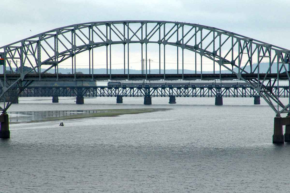
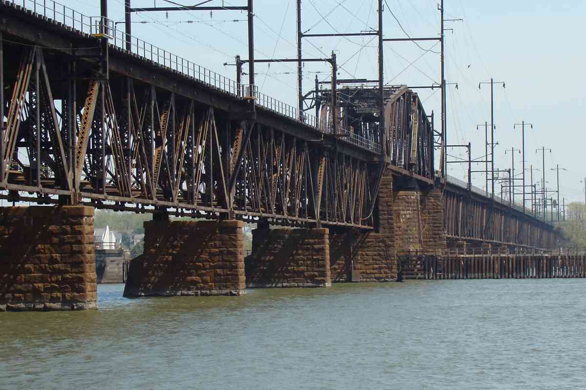
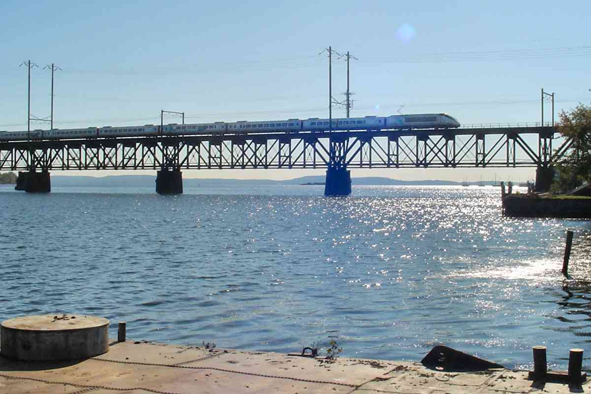
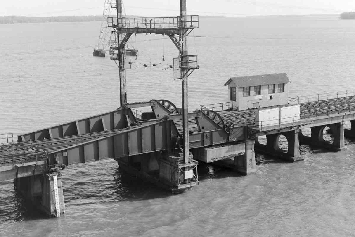
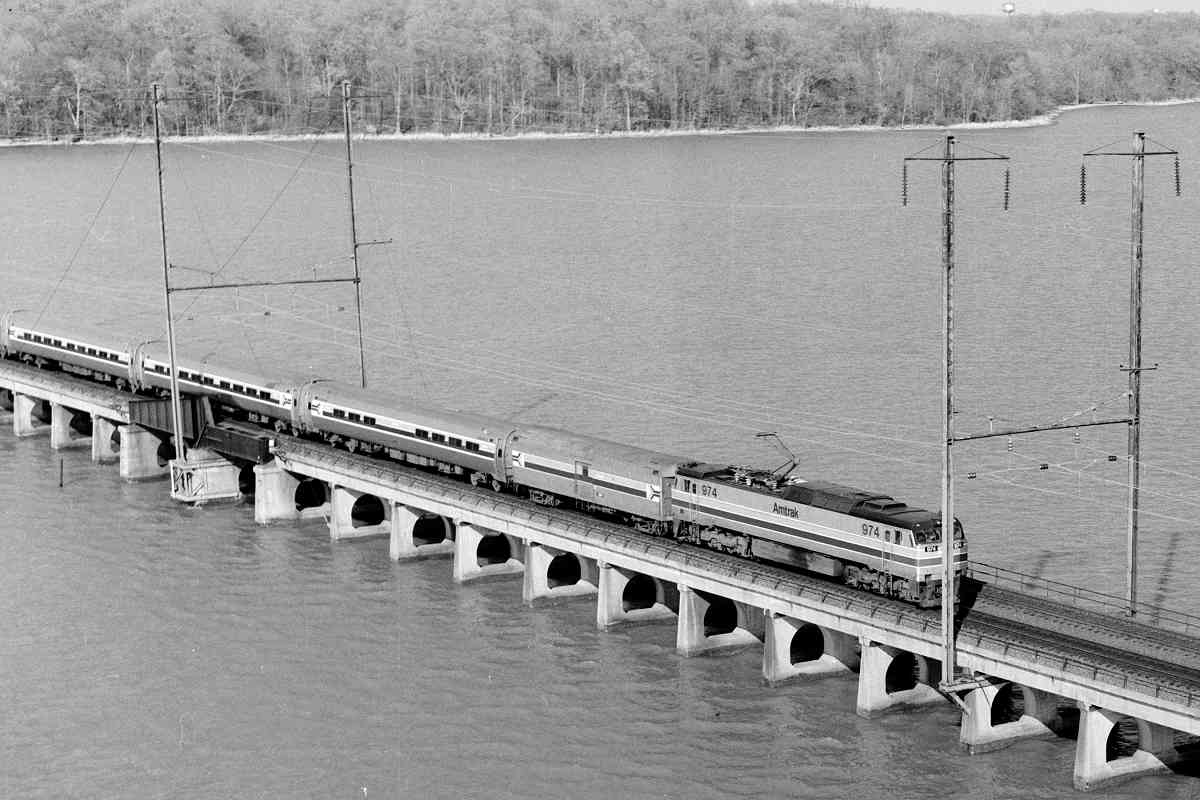
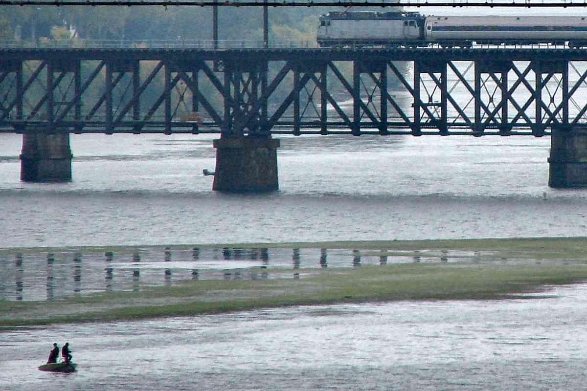
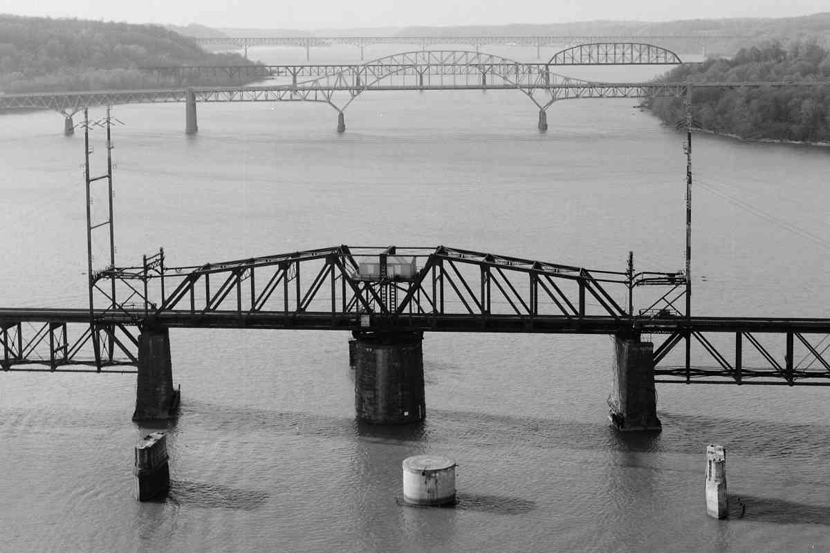
The ex-Pennsy, now Amtrak bridge was preceded by a wooden bridge on these adjacent, disused piers built by the Philadelphia, Wilmington, and Baltimore Railroad (PW&B) during the 1860s. For about 30 years prior to PW&B's bridge, ferries had floated railcars across the Susquehanna River.

After the trains had transitioned to the newer bridge, the original was repurposed and re-opened during 1910 to carry people, carts, and early automobiles. Due to the lofty tolls charged it became known as The Gold Mine Bridge.

The Gold Mine Bridge was so narrow, opposing vehicles were unable to pass each other at normal speed. After the State of Maryland purchased the bridge, during 1926 it added a second deck over the original. Unfortunately the upper deck was placed only 12.5 feet over the lower, and as vehicles grew taller, soon vertical clearance became the problem.

That was solved during 1940 by the Thomas J. Hatem Memorial Bridge that still carries US 40 across the river. The old bridge was dismantled for scrap steel during WW II, leaving the empty piers seen in this photo.

Links: 1925 photo, 1979


Blue
Photo courtesy Dave Hiteshew

Blue
Mile: 60.5 Date: Oct 2008
Ease: A- View: SE
Area: A T6: 124
Map: Ha Topographic Maps

On a bright autumn day, one of Amtrak's Acela engines points the way southwest, the general direction of this tour.

Link: 1983


Freedom Lane
Photo courtesy Dave Hiteshew

Freedom Lane
Mile: 60.6 Date: Apr 2010
Ease: A View: N
Area: A T6:
Map: Ha Topographic Maps

Once back on land, the railroad spans six local Havre de Grace streets, two by original, single-lane, stone arch bridges like this one over Freedom Lane. In case you wish to look, Google's Streeview van managed to barely squeeze under and through.


AMTK 612
NEW! late-Sep 2022

AMTK 612
Mile: 65.5 Date: Apr 2022
Ease: A- View: NE
Area: A T6:
Map: Ha Topographic Maps

Spring sun reflects off an Amtrak southbound that will not stop at Aberdeen.


Aberdeen Station
Photo courtesy Dave Hiteshew

Aberdeen Station
Mile: 65.5 Date: Jun 2010
Ease: A- View: N
Area: A T6: 129
Map: Ha Topographic Maps

Aberdeen, Maryland is the next significant town on the way southwest. Aberdeen and Perryville are the northeasternmost stops for MARC (Maryland Area Regional Commuter) trains. This express with Amtrak 2011 at the end rolled through the station; only certain local Amtrak trains stop at Aberdeen.

Link: 1976


Aberdeen Wye
Photo courtesy Dave Hiteshew

Aberdeen Wye
Mile: 65.6 Date: Jun 2010
Ease: A- View: SW
Area: A T6: 128
Map: Ha Topographic Maps

The track at distant left is part of a wye to Aberdeen Proving Ground (APG) the US Army's oldest weapons testing area, and where ENIAC, the first electronic computer, arrived during 1947 and spent most of its operational years.

Links: more about ENIAC, 2006


AMTK A29324
NEW! late-Sep 2022

AMTK A29324
Mile: 66.0, spur 0.2 Date: Apr 2022
Ease: A View: N
Area: A T6:
Map: Ha Topographic Maps

The APG spur hosts Maintenance of Way equipment from time to time. This unit is a Nordco Clip Applicator, aka Nipper Clipper.

Link: Nipper Clipper info


NS 9931
NEW! late-Sep 2022

NS 9931
Mile: 70.8 Date: Apr 2022
Ease: A- View: NE
Area: A T6:
Map: Ha Topographic Maps

North of Baltimore, it's not All Passengers All the Time. Some Norfolk Southern freights operate to the Bay View / Canton area even during daytime. The second Bush River Station had been located about a half mile north of here.


Bush River Drawspan
Photo credit Library of Congress

Bush River Drawspan
Mile: 72.0 Date: 1970s
Ease: View: S
Area: T6: 137
Map: Ha Topographic Maps

Opting for a route across several river outlets along the edge of the Chesapeake Bay meant the railroad needed several track causeways, all of which were -- and, as of 2022, still are -- double tracked and equipped with drawspans.

Links: LoC source photo, MARC on bridge 2011, NS on bridge 2012


Amtrak 2037
Photos courtesy Dave Hiteshew

Amtrak 2037
Mile: 75.1 Date: Apr 2010
Ease: A- View: E
Area: A T6:
Map: Ha Topographic Maps

Amtrak 2009 Amtrak 2037 has the green signal to continue east from Aberdeen. While CSX eliminated its Color Position Light signals, Amtrak has retained theirs.

The bright light to its left is southbound Amtrak 2009.

The trackside mechanism is a defect detector that scans for overly hot wheel bearings.


Amtrak 951
Photo courtesy Dave Hiteshew

Amtrak 951
Mile: 75.1 Date: Apr 2010
Ease: A- View: NE
Area: A T6:
Map: Ha Topographic Maps

Southbound Amtrak 951 reaches milepost 75.

By convention, Pennsylvania Railroad referred to trains along what is now Amtrak's Northeast Corridor as either southbound or northbound. This helped the Pennsylvania distinguish them from its trains between say, Philadelphia and Pittsburgh, that operated along trackage oriented more east-west than the Northeast Corridor.


Amtrak 912
Photos courtesy Dave Hiteshew

Amtrak 912
Mile: 75.1 Date: Apr 2010
Ease: A- View: W
Area: A T6:
Map: Ha Topographic Maps

signals Northbound Amtrak 912 flies through Edgewood Station.

The lower-half of Amtrak signals come in a variety of styles, sometimes individual lamps, sometimes strips of lamps, or combinations thereof. These are one of the line's easiest signals to view up close since they are over the station's platforms.

Link: 2012


Edgewood Tower
Photo courtesy Dave Hiteshew

Edgewood Tower
Mile: 75.1 Date: Apr 2010
Ease: A- View: SW
Area: A T6: 133
Map: Ha Topographic Maps

Several Pennsylvania Railroad interlocking towers survive along the Northeast Corridor, such as this masonry example at Edgewood.

Links: LoC 1970s, 2016, PRR tower list


P.R.R. Co Cover
Photo courtesy Dave Hiteshew

P.R.R. Co Cover
Mile: 75.1 Date: Apr 2010
Ease: A- View:
Area: A T6:
Map: Ha Topographic Maps

When manholes are located at stations, this style of cover is used. Few of this type with PRR text remain extant.


Gunpowder River
Photo credit Library of Congress

Gunpowder River
Mile: 78.7 Date: 1970s
Ease: View: W
Area: T6:
Map: Ha Topographic Maps

Northbound Amtrak 974 has recently crossed from Baltimore County into Harford County where the Gunpowder and Bird Rivers meet. The confluence of the rivers requires the Northeast Corridor's longest water crossing in Maryland, one just shy of a mile.

Links: LoC source photo, GG1 in 1976, 1978, 1983, 2012


Bird River

Bird River
Mile: 80.7 Date: Aug 2018
Ease: A- View: NE
Area: A T6: 131
Map: Ba 30 J 13 Topographic Maps

Once back on land the right of way typically expands to three or four tracks in width. After having crossed Bird River (distance) into Baltimore County, southbound Amtrak 655 cuts through the heat shimmer of a hot summer day. Chase Station had been located in the distance.


Crane Spur

Crane Spur
Mile: 82.0 Date: Aug 2018
Ease: B View: NE
Area: A- T6:
Map: Ba 38 F 2 Topographic Maps

This spur carried coal to the Charles P. Crane Generating Station that was decomissioned during 2018. Several similar spurs are scattered along the line, remnants of Pennsylvania Railroad's freight train era. Norfolk Southern still uses the Northeast Corridor for freight, but passenger trains greatly outnumber the freights.

Note the derail (foreground) is mechanically linked to the switch (distance) via the long rod immediately left of the track.

Links: NS PRR 8102, NS PRR 8102


Former Signal Bridge

Former Signal Bridge
Mile: 82.0 Date: Aug 2018
Ease: B View: W
Area: A- T6:
Map: Ba 38 F 2 Topographic Maps

Old signal bridges can be identified by the sturdy horizontal structure that connects catenary towers on opposite sides of the track. From time to time the railroad moves locations of signals, and their old bridges are left behind because they are integrated with the towers. Milepost 82 is at right. The nearest track rarely sees passenger trains, hence its wooden ties have not been swapped out for concrete ones.

Link: NS 5603 in 2010


Eastern Avenue

Eastern Avenue
Mile: 82.1 Date: Aug 2018
Ease: A View: W
Area: A- T6:
Map: Ba 38 F 2 Topographic Maps

The Crane Spur crosses over an Eastern Avenue that continues about 13 miles west to Baltimore's Inner Harbor.


MARC 18

MARC 18
Mile: 82.9 Date: Aug 2018
Ease: B View: SW
Area: A T6:
Map: Ba 38 D 3 Topographic Maps

Its illuminated red lamps mean MARC 18 is at the end of this commuter train, pushing it south while another MARC train (distant right) emerges from a storage track to begin its afternoon schedule.

Link: NS 9589 in 2010


Amtrak 610

Amtrak 610
Mile: 83.0 Date: Aug 2018
Ease: B+ View: SW
Area: A T6:
Map: Ba 38 D 3 Topographic Maps

Northbound Amtrak 610 charges past big-digit milepost 83.

Link: PRR 5711


Bengies Station
Photo courtesy Johns Hopkins University
NEW! late-Sep 2022

Bengies Station
Mile: 83.5 Date: Apr 1938
Ease: View: N (up)
Area: T6:
Map: Ba 38 B 4 Topographic Maps

Bengies Station was located at what had been the Bengies Road grade crossing, I have not yet determined exactly which of those structures was the station. The tall building on the north side of the tracks was probably Bengies Tower.

Due to it having just two tracks upon the outset of World War II, the stretch west from here into Baltimore was the most severe bottleneck between New York and Washington. During 1942, PRR rushed to upgrade the on-land portions to quad track so as to handle 200 trains per day, roughly one every seven minutes all day and night.

Link: tower 1934


Amtrak 625

Amtrak 625
Mile: 83.9 Date: Aug 2018
Ease: B+ View: E
Area: A- T6:
Map: Ba 38 A 4 Topographic Maps

The quad tracking remains present. Both trains are southbound, though the MARC train on the right is easing into the Martin State Airport stop.

Link: NS Jersey Central Heritage unit 2012


Car Shop

Car Shop
Mile: 83.9 Date: Aug 2018
Ease: B+ View: S
Area: A- T6:
Map: Ba 38 A 4 Topographic Maps

MARC stores and maintains railcars in the building at right that is adjacent to the Martin State Airport stop.

Links: MARC 33 getting new generator 2011, inside Wilmington, DE shop 2013


The Bike Car

The Bike Car
Mile: 83.9 Date: Aug 2018
Ease: B+ View: W
Area: A- T6:
Map: Ba 38 A 4 Topographic Maps

bike racks The Martin State Airport stop is busy enough to warrant additional MARC trains starting here, hence these storage tracks, one of which happened at photo time to host a Bike Car.

Bike Cars like unit 7710 contain special racks inside for passengers to stow the bicycles they used to get to the train, and/or to their destination. Passenger traffic flows one way through such cars.

The view at left was shot through the end door to what appear to be empty bike racks.


Amtrak 642

Amtrak 642
Mile: 84.0 Date: Aug 2018
Ease: A- View: NE
Area: A- T6:
Map: Ba 38 A 4 Topographic Maps

Amtrak 642's eyecatching red paint makes it one of the most photographed model ACS-64 units. On the side the special paint added during 2015 reads, "America's Railroad Salutes Our Veterans".

Links: side view, 1997


NS 9783
Photo courtesy Dave Hiteshew

NS 9783
Mile: 84.0 Date: Apr 2010
Ease: A- View: NW
Area: A- T6:
Map: Ba 38 A 4 Topographic Maps

Sometimes black-and-white-painted units roll through too, such as these Norfolk Southern locomotives making an uncommon daytime run. Most freight service on the line is relegated to night so as to avoid the daytime peak demand for passenger service.

Link: NS 5620 in 2010


Milepost 84

Milepost 84
Mile: 84.0 Date: Aug 2018
Ease: A- View: N
Area: A- T6:
Map: Ba 38 A 4 Topographic Maps

These prism-shaped steel mileposts date from circa 1900 when the line was, at least on paper, the Philadelphia, Baltimore and Washington Railroad. Number 84 is one of the easiest mileposts to see since it is directly across the tracks from the Martin State Airport stop's platform. To some of these mileposts Amtrak has affixed placards with larger digits.


Warthog

Warthog
Mile: 84.0 Date: Aug 2018
Ease: A- View: W
Area: A- T6:
Map: Ba 38 A 4 Topographic Maps

The catenary has snagged another drone.

Actually, the pilot in this Fairchild Republic A-10 Thunderbolt II "Warthog" aircraft was practicing landings at nearby Martin State Airport.

Links: 1996, 1997, 2011


<< Previous (index) | THIS PAGE: Susquehanna to Martin Airport | Next (southwest) >>

Or, return to main page

Copyright Notice