TrainWeb.org Facebook Page
B&O Photo Tour


B&O Philadelphia Branch
Modern day photo tour

Accompanying each photo below are:

Click a photo to see a larger view. Please send your comments and corrections to Steve.

<< Previous (west) | THIS PAGE: White Marsh to Clayton | Next (east) >>

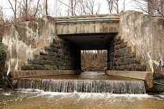
White Marsh Run
Photos courtesy Dave Hiteshew

White Marsh Run
Mile: 81.7 Date: Jan 2008
Ease: B View: NW
Area: B RBL:
Map: Ba 29 H 12 Topographic Maps

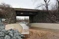
clearance Concrete buffers retard erosion at bridge 10A.

Old aerial photos show that when a nearby private grade crossing for an aggregates company closed about 1980, trucks rerouted themselves under the bridge, hence the clearance signs.

Link: 1940s


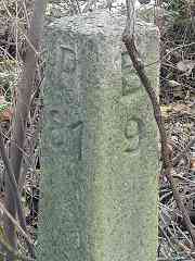
Milepost 81
Photo courtesy Dave Hiteshew

Milepost 81
Mile: 81.0 Date: Nov 2008
Ease: B View: SE
Area: A- RBL:
Map: Ba 29 J 11 Topographic Maps

Mileposts in the style of those along the Washington Branch display the distance from/to Baltimore and Philadelphia. Do these date to the 1880s opening the line? I am unsure. Their concrete is more worn at the top than sides, suggesting at least many decades of weathering, if not more than a century.


Honeygo Run
Photo courtesy Dave Hiteshew

Honeygo Run
Mile: 80.6 Date: Jan 2008
Ease: B View: NW
Area: A- RBL:
Map: Ba 29 J 10 Topographic Maps

Bridge 11A was remodeled due to erosion too; it was widened as well. An 1898 atlas places B&O's Cowenton Station off photo right; it was similar to Aberdeen Station, which follows later in this tour.

Link: bridges and stations on the line


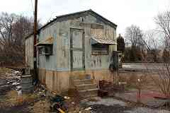
Chessie Shack
Photos courtesy Dave Hiteshew

Chessie Shack
Mile: 80.5 Date: Jan 2008
Ease: A View: NE
Area: A- RBL:
Map: Ba 29 K 9 Topographic Maps

Chessie Apparently Chessie ran out of lives at the Ebenezer Road grade crossing because CSX removed this shack while it was removing nearby CPL signals about 2010. The shack may have housed equipment related to the defect detector seen below. Maybe I looked in the wrong spot because there are reports the shack remains extant.


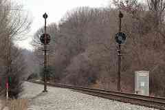
Gettin' In Tune
Photo courtesy Dave Hiteshew

Gettin' In Tune
Mile: 80.6 Date: Jan 2008
Ease: A View: NE
Area: A- RBL:
Map: Ba 29 K 9 Topographic Maps

Do these CPLs look far enough apart to permit double track? They do not to me, which means this straight and narrow section has been single tracked since the CPLs were installed during, oh, the 1940s or 1950s.


WMDD

WMDD
Mile: 80.6 Date: Jul 2016
Ease: A View: NE
Area: A- RBL: 169
Map: Ba 29 K 10 Topographic Maps

WMDD = White Marsh Defect Detector. I was going to name this as part of a then-now pair, but 8.5 years of separation does not feel sufficient!


Milepost 78
Photo courtesy Dave Hiteshew

Milepost 78
Mile: 78.0 Date: Jan 2008
Ease: B- View: NE
Area: A RBL:
Map: Ba 30 D 5 Topographic Maps

Along the US east coast this gray, featureless sky during January portends snow, except when it doesn't, as was this case this time. The snow seen in the photo below fell two days earlier.


Old Marker
Photos courtesy Dave Hiteshew

Old Marker
Mile: 78.0 Date: Jan 2008
Ease: B- View: SE
Area: A RBL:
Map: Ba 30 D 5 Topographic Maps

P78 B18 P81 B9 It's so far from the tracks you'd never spot <-- this older mile marker during leaf season. 78 + 18 = 96, and 96 is the milepost at Camden Station in downtown Baltimore. That is a logical reference point for passengers.

Wait, the marker we saw back at milepost 81 --> shows 81 + 9, which is only 90 miles total. Milepost 90 is approximately where the B&O's Belt Line and CSX's Baltimore Terminal Subdivision begin. That is not a sensible reference point since the transition from one branch to another is of no consequence to passengers.


Slab Marker
Photo courtesy Dave Hiteshew

Slab Marker
Mile: Date: Jan 2008
Ease: B- View:
Area: A RBL:
Map: Ba 30 D 5 Topographic Maps

SE_CURITY
_ H W R CO
_ - 15 1/4
_ENTED
_854
I suspect this was a marker for a property line or an underground pipeline. Anyone know more?

Link: modern utility markers


CSX 8610
Photo courtesy Dave Hiteshew

CSX 8610
Mile: 77.6 Date: Jan 2008
Ease: B View: SW
Area: A- RBL:
Map: Ba 30 E 4 Topographic Maps

Autoracks are eastbound from Baltimore lugged by CSX 8610 and CSX 5333 over Gunpowder Falls Bridge.

Link: 1981


Gunpowder Falls Bridge
Photo courtesy Dave Hiteshew

Gunpowder Falls Bridge
Mile: 77.6 Date: Jan 2008
Ease: B- View: SW
Area: A- RBL: 108
Map: Ba 30 E 4 Topographic Maps

I believe the stone to be original 1880s construction but the steel of that era was replaced with that seen here, and concrete added around 1906 to support the demands of faster trains.


Arches
Photos courtesy Dave Hiteshew

Arches
Mile: 77.6 Date: Jan 2008
Ease: B- View: SE
Area: A- RBL:
Map: Ba 30 E 4 Topographic Maps

arch It's an uncommon amalgam of stone and concrete.


CSX 733
Photo courtesy Dave Hiteshew

CSX 733
Mile: 77.2 Date: Aug 2010
Ease: A View: E
Area: A- RBL:
Map: Ba 30 E 4 Topographic Maps

CSX 733 and CSX 7495 are westbound at Jones Road.


Culvert
Photo courtesy Dave Hiteshew

Culvert
Mile: 76.7 Date: Jan 2008
Ease: B View: ?
Area: A RBL:
Map: Ba 30 G 3 Topographic Maps

During the 1880s the B&O was still building culverts out of stone though the roof appears to be steel.


Bridge 15A
Photo courtesy Dave Hiteshew

Bridge 15A
Mile: 76.5 Date: Jan 2008
Ease: B View: SE
Area: A RBL:
Map: Ba 30 G 3 Topographic Maps

Some bridges were revamped later, such as this one in 20th century style.


MoW
Photo courtesy Dave Hiteshew

MoW
Mile: 76.4 Date: Jan 2008
Ease: A- View: SE
Area: A- RBL:
Map: Ba 30 G 2 Topographic Maps

When 84 Lumber is not expecting delivery via train, their siding becomes convenient storage. This MoW unit is self-propelled.

Link: same model MoW unit on OML


Derail
Photo courtesy Dave Hiteshew

Derail
Mile: 76.4 Date: Jan 2008
Ease: A- View: E
Area: A- RBL:
Map: Ba 30 G 2 Topographic Maps

Track insulators, the orange joints, isolate the siding from the main line's signalling system. The yellow item is a derail that blocks a car on the siding from unintentionally rolling onto the main.


Switch
Photos courtesy Dave Hiteshew

Switch
Mile: 76.4 Date: Jan 2008
Ease: A- View: SW
Area: A- RBL:
Map: Ba 30 G 2 Topographic Maps

Chessie System This switch is set up for both manual and remote operation. The last time this equipment was updated, the Chessie System had not yet become CSX: the forging date is October 1984.


Little Gunpowder Falls
Photos courtesy Dave Hiteshew

Little Gunpowder Falls
Mile: 76.2 Date: Jan 2008
Ease: B View: NE
Area: A RBL:
Map: Ba 30 G 2 Topographic Maps

details Track revisions are evident at Little Gunpowder Falls. What had been double track was reduced to single.

These steel beams are not 1880s original but instead exhibit a design the B&O used during the 1920s. Note how at the support the height of the beams changes, as well as that of the wood ties.

Ties on bridges are more difficult to replace and thus to extend their life sometimes have end protectors -- the silvery-white rectangles -- installed to discourage the wood from splintering.


CSX 5317
Photo courtesy Dave Hiteshew

CSX 5317
Mile: 76.2 Date: Jan 2008
Ease: B View: SW
Area: A RBL:
Map: (Ba 30 H 2) Topographic Maps

Dusk comes early during cloudy January afternoons. The railroad called these CPLs the East Bradshaw signals.


CSX 2300
Photo courtesy Dave Hiteshew

CSX 2300
Mile: 76.2 Date: Jun 2009
Ease: B View: SW
Area: A RBL:
Map: (Ba 30 H 2) Topographic Maps

CSX 2300 is a recently repainted model GP30 that was born December 1962 as B&O 6969.

Links: more CSX 2300 pics, B&O 6969 pics


Joppa Farm Road

Joppa Farm Road
Mile: 76.0 Date: Jul 2016
Ease: A View: SE
Area: A RBL:
Map: (Ba 30 H 2) Topographic Maps

Grade separation during the years before automobiles meant enough width for horse-drawn carriages to pass, but that's not quite enough room for two at-speed autos to do so safely. Several such underpasses survive on the line in their original form.


CSX 5369
Photo courtesy Dave Hiteshew

CSX 5369
Mile: 76.0 Date: Nov 2009
Ease: B View: E
Area: A RBL:
Map: (Ba 30 H 2) Topographic Maps

westbound at milepost 76...


CSX 565
Photos courtesy Dave Hiteshew

CSX 565
Mile: 75.1 Date: Jun 2009
Ease: A- View: W
Area: A RBL:
Map: (Ba 30 K 1) Topographic Maps

xing Near the Joppa Road grade crossing old track ties are staged for pickup and landfilling. Due to their prior chemical treatment, old ties are not burned or chipped. About 700 million wooden ties support the rails of US railroads. Each lasts approximately 40 years, which means about 16 million are replaced every year.

Signals flash at the grade crossing. Note how the fixtures are offset and contain holes for light to escape from the sides so pedestrians can also be alerted. In the distance a B&O CPL is signalling approach.

Link: tie disposal


Double Culvert
Photos courtesy Dave Hiteshew

Double Culvert
Mile: 75.1 Date: Jun 2009
Ease: B View: NW
Area: A RBL:
Map: (Ba 30 K 1) Topographic Maps

An uncommon double-culvert is on duty near the crossing. This is only the third I've seen along ex-B&O lines in Maryland.


Ex-Culvert
Photo courtesy Dave Hiteshew

Ex-Culvert
Mile: 75.0 Date: Jun 2009
Ease: A View: E
Area: A RBL:
Map: (Ba 30 K 1) Topographic Maps

Piped culverts are more a 20th century expedient therefore I doubt this extracted pipe dates to original 1880s line construction.


Siding
Photo courtesy Dave Hiteshew

Siding
Mile: 74.6 Date: Jun 2009
Ease: B View: W
Area: A- RBL:
Map: Topographic Maps

The Manley-Reagan siding awaits post-disconnection cleanup. Aerial photos from 2016 show it as yet unremoved.


CPLs
Photos courtesy Dave Hiteshew

CPLs
Mile: 74.4 Date: Jun 2009
Ease: B- View: W
Area: A RBL:
Map: Topographic Maps

The G sign (grade) at the Clayton signals advises engineers they can proceed through a stop signal if needed to keep their train moving over the hill.


CSX 5241
Photo courtesy Dave Hiteshew

CSX 5241
Mile: 74.1 Date: Jun 2009
Ease: B View: W
Area: A RBL: 66
Map: Topographic Maps

That hill is more evident when traced by a train. This is the highest spot on the line west of the Susquehanna River.


Mountain Road
Photo courtesy Dave Hiteshew

Mountain Road
Mile: 74.1 Date: Jun 2009
Ease: B View: NE
Area: A RBL:
Map: Topographic Maps

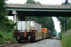
At photo time the Philadelphia Subdivision had not yet been cleared for double-stacks, so only single-stacks were on the menu.

The concrete left of the train's last car represents the location of Mountain Road's prior bridge.


<< Previous (west) | THIS PAGE: White Marsh to Clayton | Next (east) >>

Or, return to main page

Copyright Notice