TrainWeb.org Facebook Page
Old Main Line Photo Tour


B&O Old Main Line
Modern day photo tour

Accompanying each photo below are:

Click a photo to see a larger view. Please send your comments and corrections to Steve.


<< Previous (east) | THIS PAGE: Planes 3 and 4 | Next (west) >>

Map - West
Updated late-Jun 2018

Map - West
Mile: Date: Jan 2005
Ease: View:
Area: IC2: 352
Map: Topographic Map

This map covers the area from Mt. Airy west to near Monrovia.

Represented are data from Harwood (1979), USGS maps (1945, 1980), and aerial photos (1938, 1980, 2018) combined with research from hiking and photographing the area multiple times across many years.

Track alignments are depicted on the map by colors that indicate the date of opening. The same colors are overlaid on some of the photos below to assist visualizing the route.


1938 Aerial
Photo courtesy Johns Hopkins University
NEW! late-Jun 2018

1938 Aerial
Mile: 39.1 - 41.0 Date: 1938
Ease: View: N (up)
Area: A IC2:
Map: Fr 32 C 3 Topographic Maps

No photos of Mt. Airy's inclined planes in operation exist because practical photography was not invented before the Planes had been obviated by the Mt. Airy Loop track. These aerial photos capture the Planes a century after their disuse yet before an expanded US 40 and Interstate 70 erased much of their paths. These are the oldest photos I have found of the disused Planes; this is the highest resolution currently available.

Arrows mark the endpoints of indicated features. Shadow and light suggest the 600-foot ridgetop cut between Planes 2 and 3 had not yet been filled.


Plane 3 Top

Plane 3 Top
Mile: 40.2 Date: Dec 2004
Ease: A View: W
Area: A IC2: 354
Map: Fr 42 B 2, Ho 2 A 5 Topographic Maps

This is the view down from the filled cut, now spanned by Mt. Airy's Ridge Road, to the top of Plane 3 which is adjacent to the house on the left. Plane 3 is the best preserved of all the planes, and now serves as a utility access road.


uphill

Uphill
Mile: 40.4 Date: Dec 2004
Ease: B View: E
Area: A IC2:
Map: Fr 42 B 2, Ho 2 A 5 Topographic Maps

Looking back to view Plane 3's 5% grade, the steepest of the bunch... trains now avoid the whole issue by riding in relative comfort through Mt. Airy tunnel, which is underground on the left. The tunnel's grade here is 0.8%.


I-70 Grade

I-70 Grade
Mile: 40.8 Date: Apr 2005
Ease: A View: E
Area: A IC2:
Map: Fr 41 K 2, Ho 1 K 5 Topographic Maps

Eastbound trucks work a bit to overcome the last significant hill on the way to Baltimore. Plane 3 is within the trees over on the left.


Mud

Mud
Mile: 40.5 Date: Dec 2004
Ease: B View: W
Area: A IC2:
Map: Fr 42 A 2, Ho 2 A 5 Topographic Maps

At a low spot the utlity road and Plane 3 go their separate ways, with the path of the latter marked by the small gap in the forest on the right.

I was surprised to find any gap at all: the planes were removed from railroad use over 170 years ago. Or, maybe not. In misc.transport.rail.americas the late Silas Warner wrote:

    "Originally there was an inclined plane, with cables, to pull trains up into Mt. Airy on the east side, and a steep but steam-worked grade on the west side. About 1870 the B&O built the tunnel, and tore up the cable but left the west-side grade. A single car and steam engine ran up and down the west side to connect passenger trains to town."

Silas has the tunnel date wrong, which makes me question the accuracy of his other statements. But I had to get in a Silas Warner reference since during 1973 he one of the creators of the game =empire= on the PLATO computer system. PLATO did pretty much what the Internet does, except it did so a quarter-century earlier. =empire= initiated my interest in multi-user computer games, from which I started playing various railroad-themed games, which spurred me on to create my own, for which I needed photographs, which encouraged me to take RR pictures, and thus was born this site.

Link: John Daleske describes =empire=


Culvert

Culvert
Mile: 40.5 Date: Dec 2004
Ease: C View: N
Area: A IC2:
Map: Fr 42 A 2, Ho 2 A 5 Topographic Maps

What the ... ? Why is this picture here?

See the stone on the right? It's a culvert deep below the location of the prior photo. In fact, it's the only known surviving culvert along the route of the planes. And that's the reason the picture is here, because it's obviously not for being good.

The fact I survived shoe-sucking mud, a swampy brook, and shoulder-high thorny brush to get this picture has nothing to do with it. Nope.


Gap

Gap
Mile: 40.6 Date: Dec 2004
Ease: C+ View: W
Area: A IC2:
Map: Fr 42 A 2, Ho 1 K 5 Topographic Maps

This gap in the forest marks Plane 3's route down to where it meets up with the tracks of the Mt. Airy Cutoff portion of the Old Main Line and Mt. Airy Loop.


Nearing Base

Nearing Base
Mile: 40.7 Date: Apr 2005
Ease: B View: W
Area: B IC2:
Map: Fr 42 A 2, Ho 1 K 5 Topographic Maps

Emerging from the forested section yields this view to the west. The base of Plane 3 was somewhere within the area depicted here, probably just beyond the crane along the route marked in green. The tracks in the foreground are those of the Mt. Airy Cutoff, Frederick Road (MD 144) is on the right, and Mill Bottom Road connects the two.

In spring 2005 CSX cut down the century-old trees and cleared the area. A resident said the railroad told her they were merely clearing excess vegetation.


Mill Bottom Road

Mill Bottom Road
Mile: 40.8 Date: May 2004
Ease: A View: N
Area: B IC2:
Map: Fr 41 K 2, Ho 1 K 5 Topographic Maps

Before CSX chopped down the trees, this is what the area at Mill Bottom Road resembled. Here all three B&O Mt. Airy alignments make their closest approach in 3-dimensions. The tracks in the foreground are the 1901 Mt. Airy Cutoff, and those most distant (marked by magenta) are the 1838 Mt. Airy Loop. In between, 1831's Plane 3 (green) has descended from Parrs Ridge on the right, to its base in this vicinity.


Back

Back
Mile: 40.8 Date: Apr 2005
Ease: A View: E
Area: B IC2:
Map: Fr 41 K 2, Ho 1 K 5 Topographic Maps

Now we're looking back from Mill Bottom Road to see Plane 3's path.

Wait, notice the small hole the green line bisects at bottom center? What could that be? Has CSX's clearing effort uncovered an artifact? Let's climb down for a closer look.


Pulley Pit?

Pulley Pit?
Mile: 40.8 Date: Apr 2005
Ease: B+ View: E
Area: B IC2:
Map: Fr 41 K 2, Ho 1 K 5 Topographic Maps

Aha, it is an artifact! I believe it could be the remains of the foundation of the stream-powered pulley system B&O reportedly employed at the planes. If my guess is correct, this is a significant find because the very existence of the pulley system had always been in question. No evidence of it had been previously known.

The pit is embedded within a stone/brick/cement structure that is approximately 17 feet by 34 feet as outlined in the photo. The pit itself is 2.5 feet wide by 15 feet long. Debris lines the pit, 2 feet below the surface at max. There are at least 8 rods that protrude upward from the walls up to 18 inches (arrows); other rods may be hidden or broken off. I envision the pit was positioned between the rails and contained the pulley system's base wheels.

This structure is in the right place, pointing the correct direction, seems about the proper size, and is configured as one might expect. However, there is a major problem: it doesn't look old enough. The cement is too well-preserved and the rods look like they might be steel (which had not yet been invented in 1831). If it somehow dates to the 1830s, it has been preserved remarkably well. Did the trees shelter it from weathering, or is the structure more recent? And if it is modern, what was its purpose?

Over the years, I had walked in this area many times in a fruitless search for Plane 3 artifacts. Little did I know this interesting puzzle had been hiding just a few feet away. Nature is once again shrouding this artifact: the area has since been taken over by the quickly-growing, invasive ailanthus tree.


Wheel Axle?

Wheel Axle?
Mile: 40.8 Date: Apr 2005
Ease: B+ View: W
Area: B IC2:
Map: Fr 41 K 2, Ho 1 K 5 Topographic Maps

butter roller 
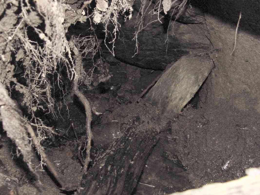
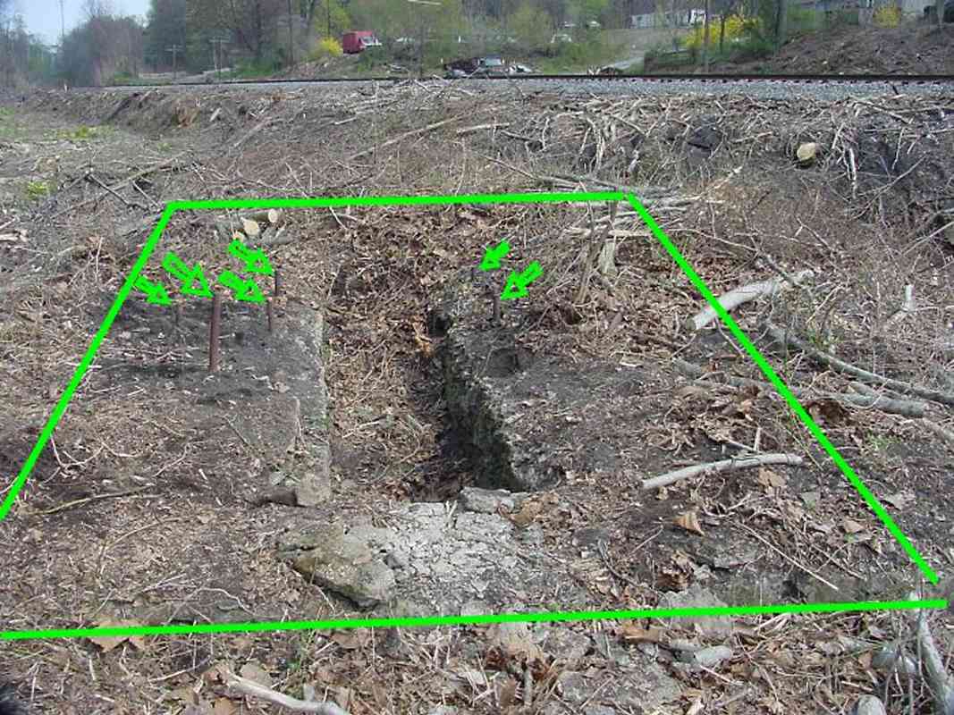
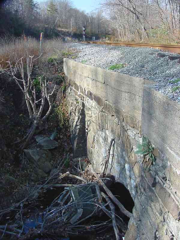
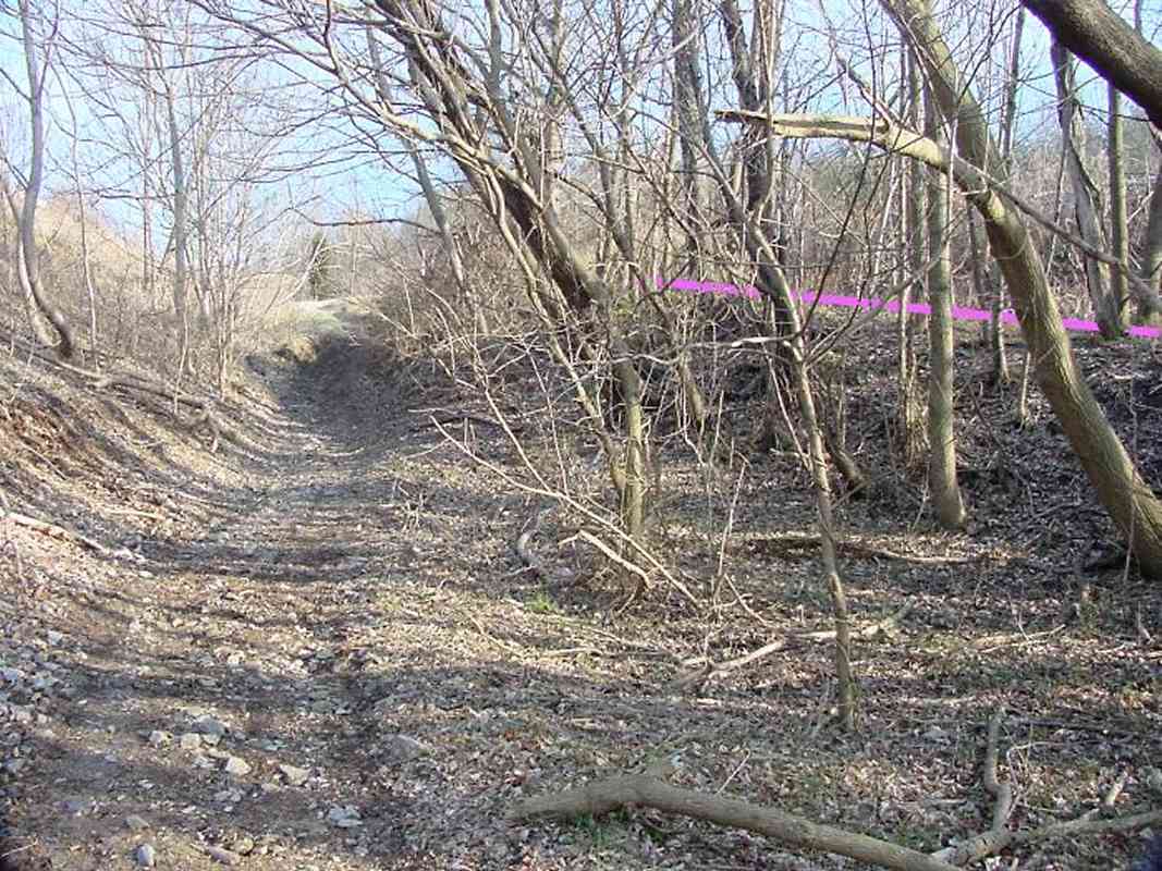
The focus of the structure is near its center where I discovered the walls uniquely contain small depressions; a small rusty pipe protrudes from one side. This is where I would expect the axle of a pulley system to reside, in a fashion similar to the restaurant butter roller pictured at left.

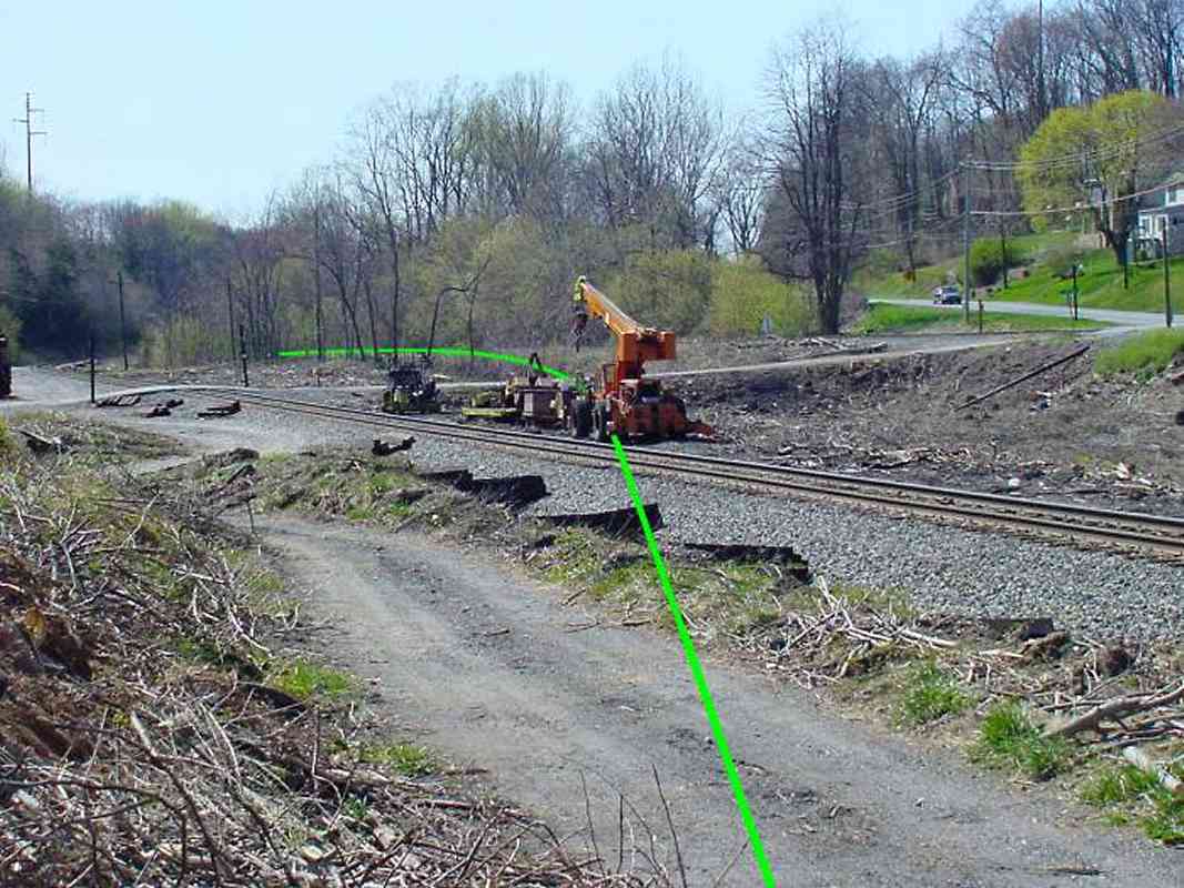
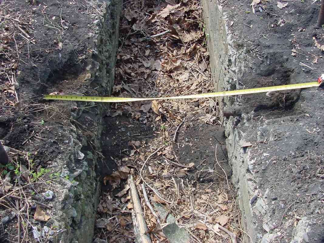
The tape measure reports the feature is 4 feet 3 inches wide, which is a good number since it fits nicely between standard gauge rails. That's supporting evidence of a railroad history for this structure.

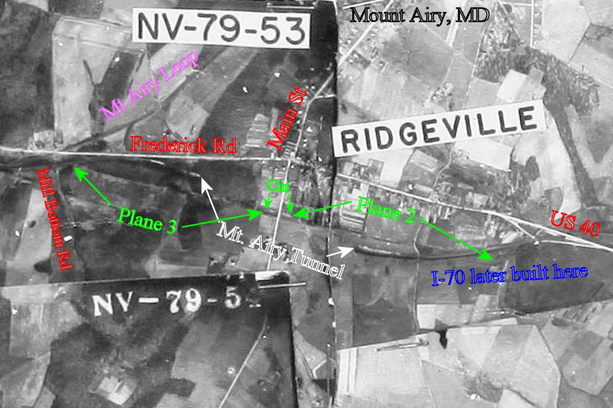
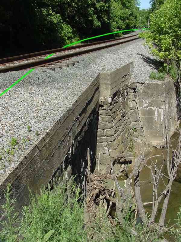
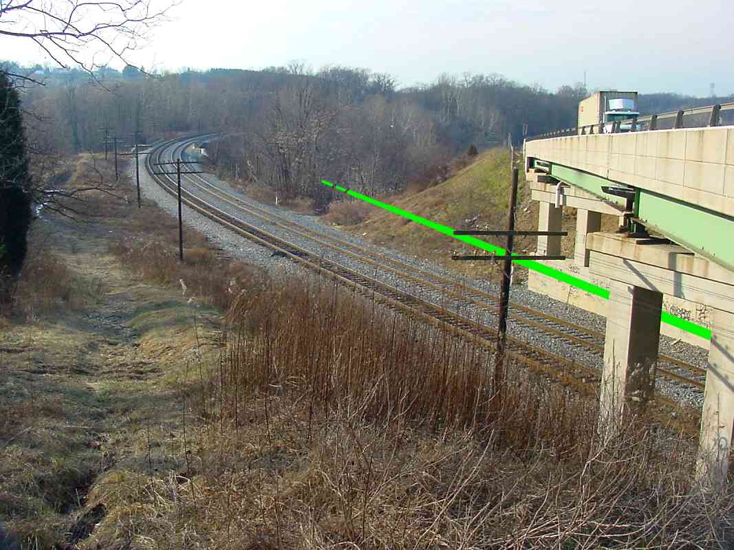
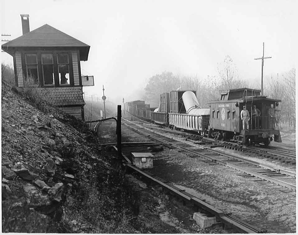
But there's another problem. Originally, B&O graced the OML with double track, so it's likely the planes were similarly double-tracked. So, why is there only one pit? Furthermore, two tracks would facilitate implementing an interconnected pulley system that counterbalanced the weight of a westbound (downhill) train to help lift an eastbound (uphill) one. The Allegheny Portage Railroad, for one, built such a system in the 1830s. Yet, in the OML's early days trains were infrequent enough B&O might have done without a counterbalanced system, or might even have single tracked the planes. Records are sparse, so there's lots of room for speculation.

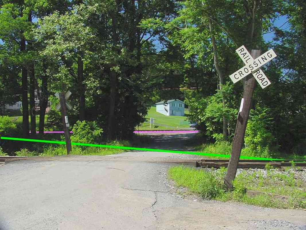
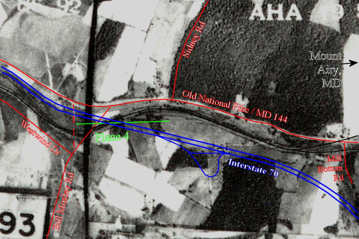
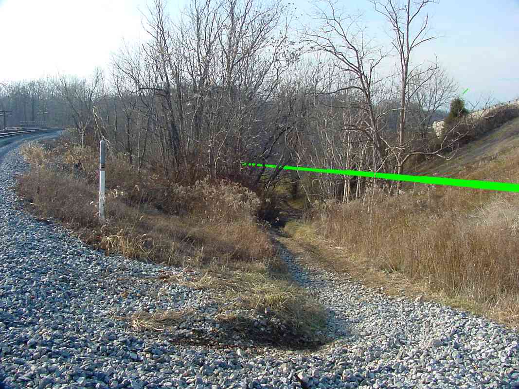
Could this structure instead be the remains of a signal tower, or water pumping station? Since the location is right, might the B&O have built it for Plane 3 use then later repurposed it? Does anyone have more information?

Link: 1820s steam-powered inclined plane of Stockton and Darlington Railway (video)


Plane 3 Base

Plane 3 Base
Mile: 40.8 Date: Oct 2004
Ease: A View: W
Area: A IC2:
Map: Fr 41 K 2, Ho 1 K 4 Topographic Maps

At the base of Plane 3, both forms of lifting assistance (the horses and the pulley system) would have required a level staging area where the trains could be connected. That's this location, near the Frederick Road (MD 144) grade crossing of the still-in-service Mt. Airy Loop. The pulley pit is hidden behind the trees on the extreme left.

According to data published by Harwood, B&O's original route wandered west from here over level ground for 3687 feet which included a masonry bridge and a wood trestle.

Link: 1920 reverse view


Arched Bridge

Arched Bridge
Mile: 40.9 Date: Nov 2004
Ease: B View: W
Area: B IC2:
Map: Fr 41 K 2, Ho 1 J 5 Topographic Maps

Here's the masonry bridge. It now carries the Mt. Airy Loop over Bush Creek.

Two things to note: 1) the style of masonry work of the arch stones matches that of only one other early B&O bridge, the original twin arch bridge over the Patapsco River between Planes 1 and 2, and 2) the angle of the bridge does not quite line up parallel to the Loop's track. For these reasons I believe this bridge was initially built in 1831 for use with B&O's original inclined plane route.


1831 Bridge

1831 Bridge
Mile: 40.9 Date: May 2004
Ease: B View: NE
Area: B IC2:
Map: Fr 41 K 2, Ho 1 J 5 Topographic Maps

This view looks the opposite direction back up the Mt. Airy Loop track toward Frederick Road.

Note how the arched (closest) portion of the bridge does not align with the track. When the Loop (magenta on the map) was built a few years later to replace the planes, the curve here was changed, necessitating a differently-angled addition to the bridge.

The concrete that tops the bridge implies its height was increased from the original. Both the original 1831 alignment and the 1838 Loop alignment had traversed this area at a slightly lower elevation.


Mt. Airy Junction

Mt. Airy Junction
Mile: 41.0 Date: May 2004
Ease: B View: W
Area: B IC2:
Map: Fr 41 K 2, Ho 1 J 5 Topographic Maps

Cutoff to the left, Loop to the right, stuck in the middle with a hue of green is the plane's route. B&O's MA Tower had stood on the left.

While the length of the level area between Planes 3 and 4 is documented as 3687 feet, its exact route was obscured by the new alignments. The green line represents my best estimate of the original alignment. As it fades into the distance, heading for what had been Plane 4, notice how it does not descend like the existing tracks do: the original alignment was on a level grade between planes.

The Loop took the place of Planes 1, 2, and 3, but not Plane 4 which was a short distance further west. My research indicates B&O opted to spread Plane 4's steepness across a few miles of regraded track.

CSX removed the weary CPL (signal in center) later in 2004.

Link: MA Tower 1952


Plane 4 Line
Photo courtesy Johns Hopkins University
NEW! late-Jun 2018

Plane 4 Line
Mile: 41.0 - 42.0 Date: 1938
Ease: View: N (up)
Area: A IC2:
Map: Fr 41 H 2 Topographic Maps

As it did for other planes, this low-resolution composite aerial from 1938 shows a straight line of trees where one would expect to find Plane 4. Because this line of trees is 1900 feet long, the plane's historically documented length, it is reasonable to conclude these trees echo Plane 4's path a century after B&O ceased using it.

Plane 4 extended south of and parallel to Old National Pike, Maryland 144, from Sidney Road west to Bill Moxley Road's former location. Between those endpoints, Plane 4 had existed where Interstate 70 now bridges the current railroad.


Sidney Road

Sidney Road
Mile: 41.5 Date: Nov 2004
Ease: A View: S
Area: A IC2:
Map: Fr 41 H 1, Ho 1 H 4 Topographic Maps

If you visit at the right time of day and season, the sun helps to illuminate "shelves" upon which various alignments had perched. This is the view looking south from the intersection of MD 144 and Sidney Road.

At top left the green line marks B&O's original 1831 alignment; it stayed level between the base of Plane 3 (farther left) and the top of Plane 4 (here). Records indicate a wooden bridge had spanned a dip in the land just east of Plane 4 but subsequent regrading has obscured that dip.

The black line shows the currently active Mt. Airy Cutoff alignment as it descends from the ridge.

The magenta line illustrates the 1838 alignment, constructed at the same time as the Mt. Airy Loop. The roughly 2-mile-long regrade eliminated the need for Plane 4. Note how its slope is roughly the same as that of the Cutoff.

Bush Creek flows at the bottom of the hillside, and the pavement of MD 144 is seen in the foreground.


I-70
Updated late-Jun 2018

I-70
Mile: 41.5 Date: Jan 2005
Ease: A View: W
Area: A IC2:
Map: Fr 41 J 2, Ho 1 H 5 Topographic Maps

If Plane 4 still existed it would cut across I-70 west of Mount Airy about as shown, though at a lower elevation than depicted by the green line, i.e. it would be beneath the pavement and descending into the distance.

At the white van ahead I-70 spans the current railroad.


From I-70

From I-70
Mile: 41.5 Date: Jan 2005
Ease: A? View: N
Area: A IC2:
Map: Fr 41 H 2, Ho 1 H 4 Topographic Maps

However tempting it may be to say that bright line of snow is a Plane 4 artifact, careful measurements put Plane 4 parallel to it but closer to the camera. The excavation came after Plane 4 was disused. This is a view from I-70 looking north.


Snow

Snow
Mile: 41.5 Date: Jan 2005
Ease: A? View: NW
Area: A IC2:
Map: Fr 41 H 2, Ho 1 H 4 Topographic Maps

West of the excavation, I believe Plane 4 ran through a cut on the far side of the this line of snow that highlights the cut's southern edge.


Driveby

Driveby
Mile: 41.6 Date: Jan 2005
Ease: A? View: NE
Area: A IC2:
Map: Fr 41 H 2, Ho 1 H 4 Topographic Maps

From a little further west on I-70 you can look back to see both the plane's alignment (white stripe above guardrail) as well as, at a lower elevation, the present-day double trackage of the Mt. Airy Cutoff.


Plane 4 Top
NEW! late-Jun 2018

Plane 4 Top
Mile: 41.5 Date: May 2005
Ease: B- View: W
Area: A IC2:
Map: Fr 41 H 2, Ho 1 H 4 Topographic Maps

The excavated area is off photo left. According to my measurements, that's where Plane 4 had been rather than along this path. There remains little to see of Plane 4, even after the snow melts. Perhaps some artifacts, such as a stone foundation, survive somewhere in the brush but I found none.


Plane 4 Path
Updated late-Jun 2018

Plane 4 Path
Mile: 41.7 Date: Dec 2004
Ease: B View: W
Area: A IC2:
Map: Fr 41 H 2, Ho 1 G 4 Topographic Maps

Plane 4 descended about as shown by the green line. The current railroad and I-70 intersect along Plane 4's route. Harwood's data says the plane was 1900 feet long and dropped 81.4 feet to a base at Bush Creek, for a 4.3% average grade. Elevation data from Google Earth confirm an 80 foot drop along the Plane 4 path described by this tour page.

The next photo zooms down immediately across the tracks.

Link to older picture: 1985


Plane 4?

Plane 4?
Mile: 41.8 Date: Dec 2004
Ease: B View: W
Area: A IC2:
Map: Fr 41 H 2, Ho 1 G 4 Topographic Maps

Upon first glance it is tempting to call this ATV path Plane 4. By comparing the 1938 aerial photos with modern ones, I put Plane 4 a few feet to the north (right), as illustrated by the green line.


Regrade

Regrade
Mile: 41.8 Date: Dec 2004
Ease: B+ View: E
Area: A IC2:
Map: Fr 41 G 2, Ho 1 G 4 Topographic Maps

Looking uphill back toward the location of the prior photo reveals a graded shelf of land on the right. Initially I was tempted to call this Plane 4, but after looking more closely, the shelf carves out a curve. The planes were straight segments. Instead I believe the shelf to be part of the regrade that replaced Plane 4 in 1838. Plane 4 was immediately adjacent on its left (north), running through the center of this photo.


Bill Moxley Road
NEW! late-Jun 2018

Bill Moxley Road
Mile: 41.8 Date: May 2004
Ease: B+ View: N
Area: A IC2:
Map: Fr 41 G 2, Ho 1 G 4 Topographic Maps

As seen from Bill Moxley Road, Plane 4 existed between the current railroad (near bridge) and I-70 (far bridges).


Plane 4 Base

Plane 4 Base
Mile: 41.9 Date: Dec 2004
Ease: B View: W
Area: A IC2:
Map: Fr 41 G 2, Ho 1 G 4 Topographic Maps

Records state the base of Plane 4 was near Bush Creek at an elevation of 576 feet. Topo maps say this is the spot; I-70 is behind the trees and CSX bridge 30B behind the photographer. The creek-bank stones are not squared off like those used in B&O bridges, so are unlikely to be relics. If there are artifacts hiding, I've not been able to uncover them here. Hey, where are those CSX tree choppers when you need 'em?


Plane 4 Lives

Plane 4 Lives
Mile: 42.6 Date: Apr 2005
Ease: A View: N
Area: A IC2:
Map: Fr 41 F 1, Ho 1 E 3 Topographic Maps

Plane 4 is long gone but not forgotten. People were needed at its base to assist with the horses (and maintain the purported steam winches), and a tiny community grew up nearby. Over a century and a half later, the Plane 4 name lives on at this repair shop west of Woodville Road.


<< Previous (east) | THIS PAGE: Planes 3 and 4 | Next (west) >>

Or, return to main page

Copyright Notice