TrainWeb.org Facebook Page
Old Main Line Photo Tour


B&O Old Main Line
Modern day photo tour

Accompanying each photo below are:

Click a photo to see a larger view. Please send your comments and corrections to Steve.


Sykesville - Brief Historical Background:

Looking East

Looking East
Mile: 28.3 Date: Oct 2003
Ease: B View: E
Area: A IC2: 71
Map: Ca 35 A 4, Ho 5 B 5 Topographic Maps

Looking back toward Baltimore, the Old Main Line emerges from a quiet stretch of rural trackage between Henryton and Sykesville. If the utility poles appear to diverge from the tracks, it's because they do: the original alignment (green line) swept a curve farther from the river.


Looking West

Looking West
Mile: 28.3 Date: Oct 2003
Ease: B View: W
Area: A IC2: 205
Map: Ca 35 A 4, Ho 5 B 5 Topographic Maps

Turning around at the same location yields a view of just one example of dozens of small curves B&O straightened along the OML. The original curves are depicted on valuation maps, or "val maps", the railroad drew in the early 1900s. You can order copies of these old val maps from CSX, but 1) they are pricey, about $50 per track mile, and 2) in my experience the CSX map department doesn't answer their phone nor return calls.

The fall foliage remains browned and tattered from the visit of Hurricane Isabel during the prior month. Ahead is the bridge that carries MD 32 over the river and tracks.


MD 32

MD 32
Mile: 28.5 Date: Mar 2003
Ease: B+ View: SE
Area: A IC2: 304
Map: Ca 35 A 4, Ho 5 A 5 Topographic Maps

The tracks have been shored up to help withstand the pounding of pile drivers and other equipment as a replacement for the deteriorating Sykesville Bypass bridge is hurried into place.

The bridge was built in 1963, and survived the 1972 flood, but its unusual aluminum girder construction was undone by a materials problem: steel load bearing pads. The mixture of metals encouraged corrosion via galvanic action, leading to premature deterioration. The same effect occurs with "silver" amalgam dental fillings, causing mercury to leach from the fillings.

Link: more about the bridge


Tavern

Tavern
Mile: 28.5 Date: Mar 2003
Ease: A View: W
Area: B+ IC2: 88
Map: Ca 35 A 4, Ho 5 A 5 Topographic Maps

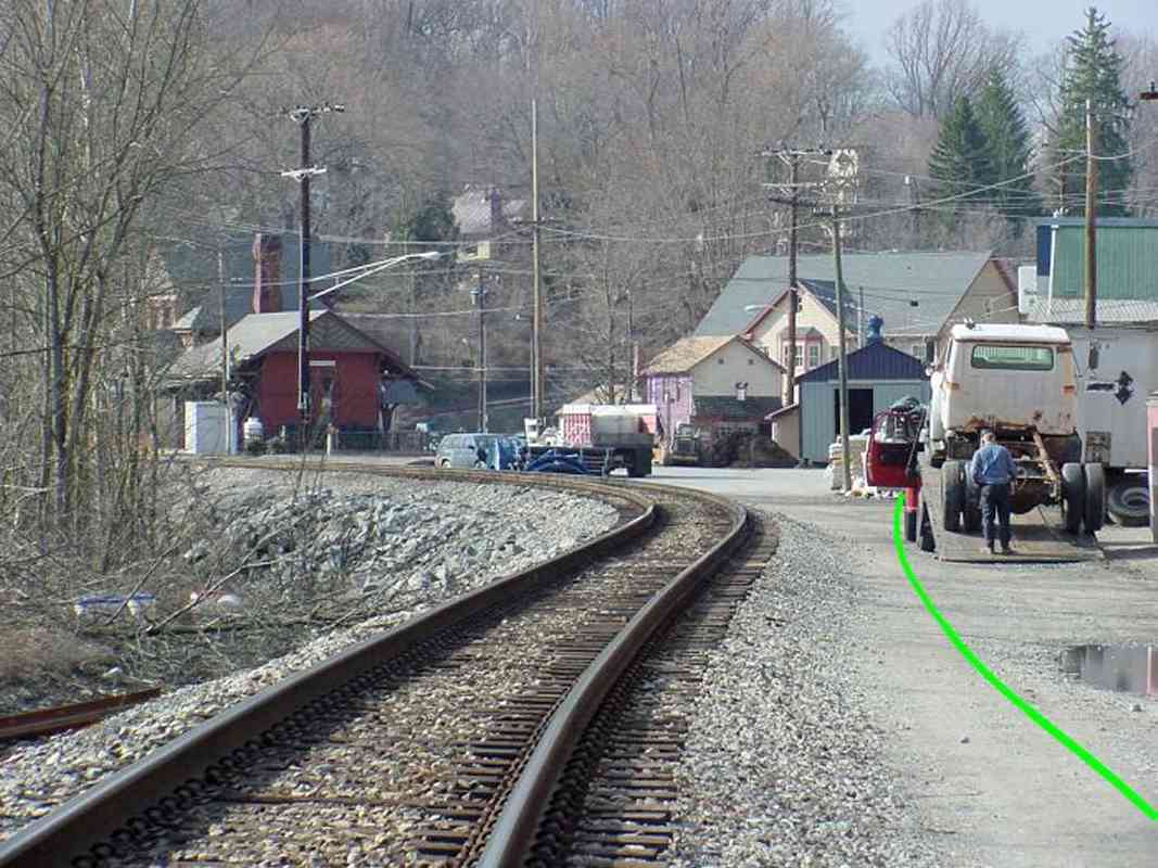
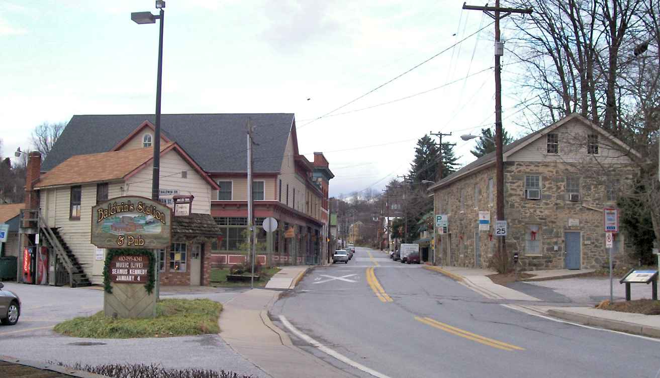
Acting as history's bookend, B&O's second train station in Sykesville (the red brick building at distant left) is now occupied by a restaurant. 
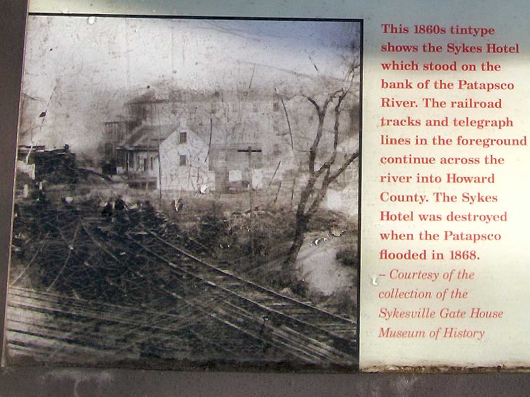
Conversely, B&O's first station started life as a restaurant (tavern) and 47-room hotel; it had been situated to the left of where the blue-shirted man is standing.

That first station survived almost 40 years sandwiched precariously between the tracks and the river until the huge flood of 1868 swept it, and much of the town, away. If it looks like there is not enough room for a hotel, be aware that the river has been rerouted by floods and man's efforts.

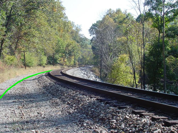
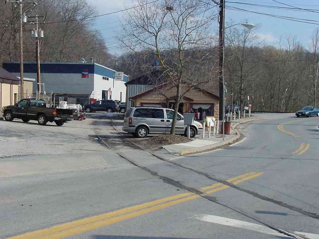
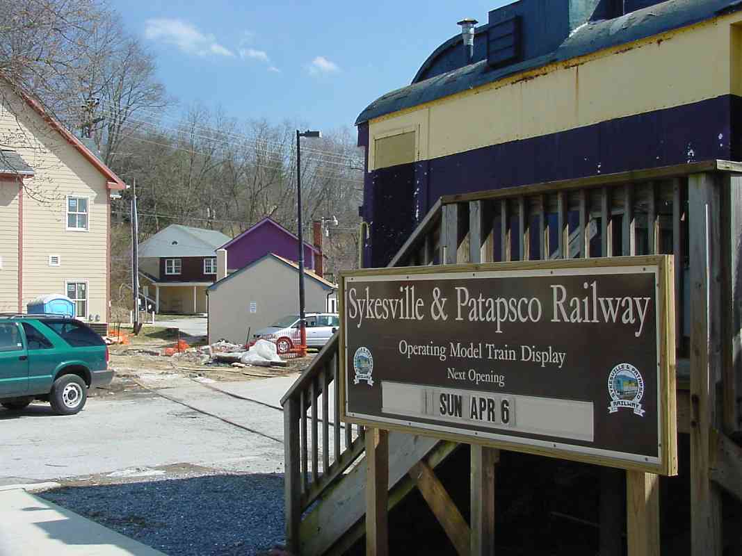
For future reference, note the purple building at distant center: The original alignment followed the green line west and tracked adjacent to that building.


1860 Map

1860 Map
Mile: 28.6 Date: 1860
Ease: View: N (up)
Area: IC2:
Map: Ca 35 A 4, Ho 5 A 5 Topographic Maps

At the eve of the Civil War, most Sykesville residents lived on the Howard County (south) side of the river. On the north side, the tavern/hotel, a store (Zimmermann) and post office were squeezed between the river and railroad.

After the 1868 flood demolished most of the town, residents rebuilt on the Carroll County (north) side, the land of which rises somewhat more steeply from the river thereby offering some flood protection.


Sykes Hotel
(Photo courtesy Paul Van Bloem)

Sykes Hotel
Mile: 28.7 Date: 1860s (Dec 2006)
Ease: A View: SE (NE)
Area: B+ IC2:
Map: Ca 35 A 4, Ho 5 A 5 Topographic Maps

A descriptive historical sign in downtown Sykesville includes a vintage picture of the hotel with a westbound steam engine poised in front, plus store and post office prior to the 1868 flood.

The sign's text is incorrect about the railroad crossing the river into Howard County: all the artifacts from that time period I've found are on the Carroll County side. West of here the railroad does briefly traverse back into Howard County, but did not do so until the Sykesville Tunnel was added during the 20th century. However, if that steam engine operates in reverse, it will return to Howard County in about four miles.


Relics

Relics
Mile: 28.7 Date: Mar 2003
Ease: A View: SE
Area: B+ IC2:
Map: Ca 35 A 4, Ho 5 A 5 Topographic Maps

This was snapped roughly from the same location as the 1860s photo above, but the scene is very different today.

Sykesville embraces its railroad history, and at Main Street has never seen fit to pave over the long-disused steel relics of the original B&O alignment. The purple building noted earlier is behind and to the right of the photographer, and the current tracks are found behind the blue car at this photo's right edge.


Main Street 1935

Main Street 1935
Mile: 28.7 Date: 1935
Ease: A View: N
Area: A IC2: 133
Map: Ca 35 A 4, Ho 5 A 5 Topographic Maps

The same track relics, likely then in use as a siding, cross Main Street in this 1935 view north from the B&O station.


Main Street 2006
Photo courtesy Paul Van Bloem
Updated Oct 2008

Main Street 2006
Mile: 28.7 Date: Dec 2006
Ease: A View: N
Area: B+ IC2: 133
Map: Ca 35 A 4, Ho 5 A 5 Topographic Maps

Little other than vehicles and signage changed in 71 years. Hiding behind the Baldwin's Station and Pub sign is the purple building, recently repainted in a more subdued color.

Richard Lyons, former Sykesville Fire Department Chief, kindly wrote about the history of the building:

    "Steve, you mention the tracks going to the right of the 'purple building' in the Sykesville Approach photo. Maybe irrelevant to this site, but that building is the first and original firehouse for the Sykesville Fire Company which just celebrated its 75th anniversary. They used that firehouse starting in the 1930s until the start of WW2, when the company moved into the stone 'church' building just up and across Main Street. Moved into the 'state of the art' firehouse farther up Main Street in 1949, staying there until 1983, when we consolidated our 2 stations at the current location on Rt 32 in Flohrville. I do not know if that building was used or new when the Fire Co. moved in. It has been used for several businesses since, from a general store to a 'crab shack'. I have heard tales from some of the old-timers of having to wait for railcars to be moved so the firemen could get to the firehouse and so the truck could go 'uptown'."


S&P Railway

S&P Railway
Mile: 28.8 Date: Mar 2003
Ease: A View: E
Area: B+ IC2: 205
Map: Ca 35 A 4, Ho 5 A 5 Topographic Maps

West of the purple building, the relic siding is home to a stranded C&O passenger car that now hosts displays of the Sykesville & Patapsco Railway.


C&O Passenger Car

C&O Passenger Car
Mile: 28.8 Date: Apr 2001
Ease: A View: NW
Area: B IC2:
Map: Ca 35 A 4, Ho 5 A 5 Topographic Maps

Here's a better view of the C&O passenger car. The car is on loan to the town of Sykesville where it is maintained by a volunteer organization. The red B&O caboose in the distance has been restored by, I think, the same group.

Reader Joe Moltz kindly wrote to fill in the details:

    "As Vice President of the Sykesville and Patapsco Railway, I'd like to add a little more info for your Sykesville photos. The passenger car is a 1910 C&O Parlor car built by Pullman. It served on the C&O till it became an office car and saw its last duty as such in Laurel, Md. It was donated to the B&O Museum and then transferred to Sykesville in 1991.

    "Currently the car houses model train layouts in O and HO scales operated by the S&P Railway club. We are open the first Sunday of each month with special Christmas openings in December.

    "The Caboose is a 1925 ex B&O type I-5, I believe. It houses the N Scale layout of the S&P and is open at the same time as the Pullman car."


B&P Tower

B&P Tower
Mile: 28.8 Date: Oct 2003
Ease: A View: S
Area: B+ IC2:
Map: Ca 35 A 4, Ho 5 A 5 Topographic Maps

Adjacent to the C&O passenger car is a reconstruction of a Baltimore & Potomac Railway interlocking tower that had served the railroad from 1910 to 1988 at a location near Penn Station in Baltimore. When construction of Baltimore's Light Rail threatened the tower, portions were saved and eventually incorporated in the building seen here.

It now houses a contract post office and Old Main Line Visitor's Center.

Links: ~1977, ~1990, 2003


B&O Mark

B&O Mark
Mile: 28.9 Date: Mar 2003
Ease: B View: N
Area: B IC2:
Map: Ca 34 K 4, Ho 4 K 5 Topographic Maps

There aren't many artifacts remaining to be found with a B&O name, so when I do find one, it's worth a photo. Part of the iron tie plate (someone please tell me the proper terminology) on the siding here bears a B&O mark while its neighbor on the left reveals it is from Beth(lehem Steel). It has been a few years since these were installed...

Reader Mike Brown wrote to say:

    "The device in question is called a 'rail brace'; these are used on stock rails, adjacent to switches to prevent the rail from rolling out when a train passes. There are no spikes or fasteners along the inside of the stock rail along the switch point.

    "Rail Braces can also be found on inside guard rails on bridges and along the running rail on very sharp curves.

    "PS: killer web site, kept me up all night . . . Thankx for doing all of the hard work!"

Thanks much for the info, Mike.


Rejoin

Rejoin
Mile: 28.9 Date: Mar 2003
Ease: B View: E
Area: B+ IC2:
Map: Ca 34 K 4, Ho 4 K 5 Topographic Maps

In this view back to Sykesville, from the spot at which the original alignment and present-day one meet, the tower's red roof is at center. The rusty rails tell us the tracks on the left no longer see much use.


Steamer
Photo courtesy HH Harwood collection

Steamer
Mile: 28.9 Date: 1949
Ease: View: E
Area: IC2:
Map: Ca 34 K 4, Ho 4 K 5 Topographic Maps

Those rails were not rusty when in 1949 B&O 4427 puffed westward. The prior photo was snapped from almost the same spot, as evidenced by the tall building at left, where you'll find another steam engine. The OML witnessed its last regular-service steam engines in the 1950s.


Continue along the current alignment west from Sykesville

Or, return to main page


Copyright Notice