TrainWeb.org Facebook Page
Old Main Line Photo Tour


B&O Old Main Line
Modern day photo tour

Accompanying each photo below are:

Click a photo to see a larger view. Please send your comments and corrections to Steve.


<< Previous (east) | THIS PAGE: Frederick Junction to Eastalco | Next (west) >>

New Signals

New Signals
Mile: 54.2 Date: May 2001
Ease: A View: W
Area: A IC2: 391
Map: Fr 38 J 1 Topographic Maps

Back at Frederick Junction, new signals were installed to support MARC service. They are seen here just days after replacing CPL-style signals, and are still turned to prevent misinterpretation before they are powered up and checked.

The overpass is that of Urbana Pike, MD 355.


B&O 4469
Photo courtesy Herb Harwood collection

B&O 4469
Mile: 54.2 Date: Feb 1950
Ease: A View: NE
Area: A IC2: 297
Map: Fr 38 J 1 Topographic Maps

Steam and diesels meet at Frederick Junction in 1950, just prior to the ~50 year pause in passenger service. The photographer is standing under the MD 355 overpass, and looking the opposite direction of the prior photo.

Link: station photo


CSX 207
Photo courtesy Dave Hiteshew
NEW! Aug 2007

CSX 207
Mile: 54.3 Date: May 2007
Ease: B View: SW
Area: A IC2:
Map: Fr 38 H 1 Topographic Maps

Exhaust from CSX 207 and 229 blur the sky as they haul coal eastbound under I-270.


Snowbound
Photo courtesy Herb Harwood collection

Snowbound
Mile: 54.5 Date: 1950s
Ease: B View: W
Area: A IC2:
Map: Fr 38 H 1 Topographic Maps

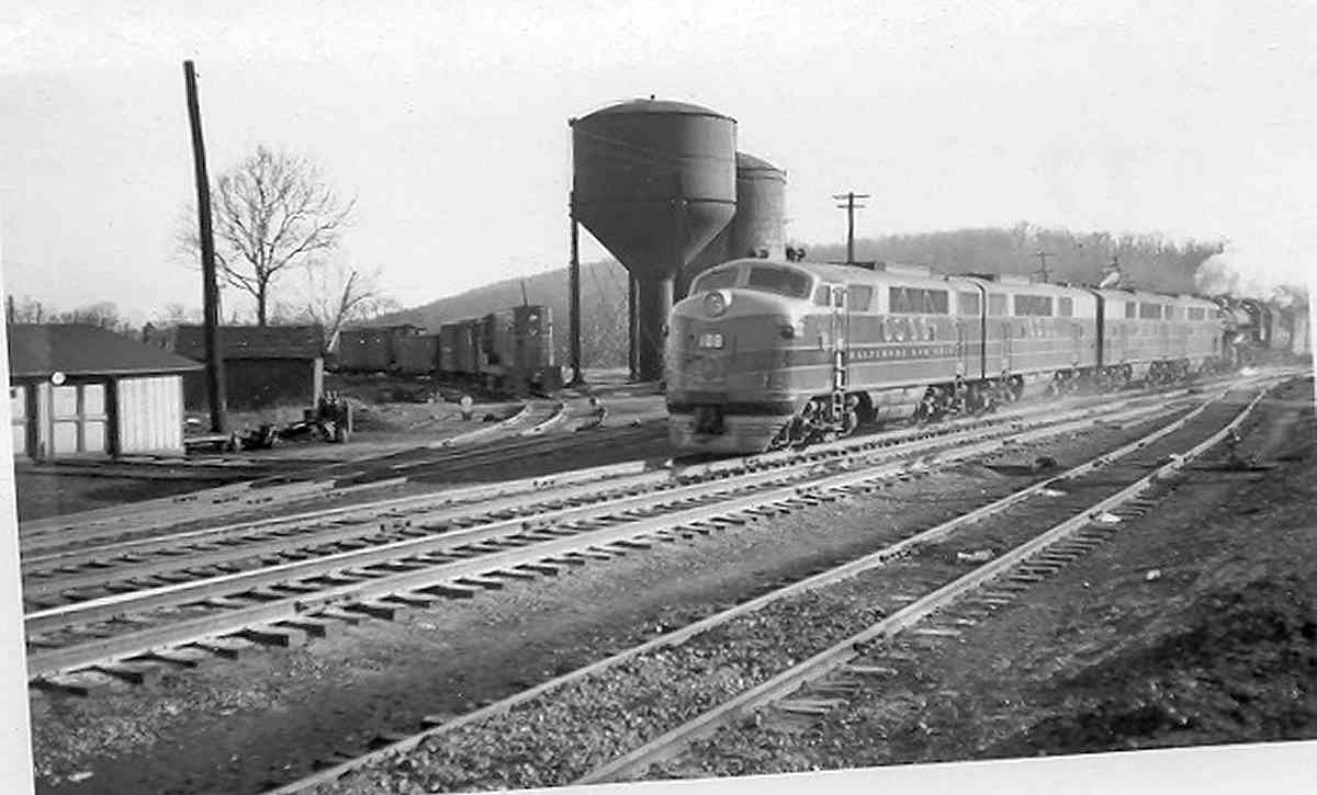
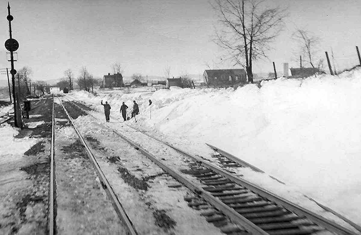
Information included with this snowy photo claims it was snapped near Frederick Junction, but determining its exact location was an interesting puzzle. In fact, I had begun to think that perhaps this was not in the vicinity of the Junction.

There appears to be an overpass in the distance, and the sun angle implies this view looks west. The pictured overpass cannot be MD 355 since the Monocacy River or Frederick Junction wye would be visible in the foreground, and I had (incorrectly) thought MD 355 was the only overpass in the vicinity during this time frame.

Reader Al Moran clued me in that US 240, the predecessor to I-270, was already in place by 1953, and the distant overpass was likely that road. He added, "The thing that really makes me think it IS Frederick Junction are the mountains in the background. When you drive down 15 and 340, that's what it looks like."

Additional research shows there had been sidings just west of Frederick Junction, and those sidings can be seen in this photo. Thus, the puzzle has been solved: the pictured location is between MD 355 and what is now I-270.

Link: I-270 info


Culvert
Photo courtesy Dave Hiteshew
NEW! Aug 2007

Culvert
Mile: 55.0 Date: May 2007
Ease: B View: N
Area: A IC2:
Map: Fr 38 G 1 Topographic Maps

All the box culverts west of Frederick Junction show signs of modification from their original form. This one uses an unusual type of stone, and has deterorating mortar at the joints, both signs that it was rebuilt after the 1830s.


Milepost 55
Photo courtesy Dave Hiteshew
NEW! Aug 2007

Milepost 55
Mile: 55.0 Date: May 2007
Ease: B View: E
Area: A IC2:
Map: Fr 38 G 1 Topographic Maps

Mile marker 55 works on its tan while its predecessor "mile marker on a rail" prefers the shadier spot on the right. In the distance is the I-270 overpass.


Milepost 55
Photo courtesy Dave Hiteshew
NEW! Aug 2007

Ballenger Creek
Mile: 55.5 Date: May 2007
Ease: C+ View: E
Area: A IC2:
Map: Fr 38 F 2 Topographic Maps

The bridge over Ballenger Creek suprises with its concrete lining, a style unseen along the OML since back near mile 9 at Avalon.


McKinney Spur
Photo courtesy Dave Hiteshew
NEW! Aug 2007

McKinney Spur
Mile: 55.7 Date: May 2007
Ease: B View: SW
Area: A IC2:
Map: Fr 38 E 3 Topographic Maps

A rusty, but still-operational spur serves the McKinney Industrial Park. Note the special timber enclosure to support the switch. Other spurs in this vicinity, such as one about a 1000 feet ahead, have been disconnected from the OML in order to reduce wear on the equipment and the chances of a derailment. Derailments happen at switches more often than at non-switch locations.


Brace 1949
Photo courtesy Dave Hiteshew
Updated Nov 2012

Brace 1949
Mile: 55.9 Date: May 2007
Ease: B View: NW
Area: A IC2:
Map: Fr 38 E 3 Topographic Maps

Bracing for that disconnected spur shows a casting date of August 1949.

Reader Don Damour comments:

    "What appears to be a brace in the photo is probably a guard rail for a switch. I used to work for a short line and have done a lot of trackwork."


Muffins

Muffins
Mile: 56.0 Date: Sep 2005
Ease: A View: N
Area: A IC2:
Map: Fr 38 E 3 Topographic Maps

The smell of freshly baked bread mingles with that of creosote outside the Thomas' English Muffin bakery. No tank engines were seen, though several other industrial parks in this area receive train service.


Harmon

Harmon
Mile: 56.1 Date: Sep 2005
Ease: A View: SE
Area: A IC2:
Map: Fr 38 E 4 Topographic Maps

Some sort of detector sits adjacent to the rails here. The name on the box is Harmon. Anyone know what it does?


Spurs
Photo courtesy Dave Hiteshew
NEW! Aug 2007

Spurs
Mile: 56.2 Date: May 2007
Ease: B+ View: SW
Area: A IC2:
Map: Fr 38 E 3 Topographic Maps

Polished rails attest that several industrial parks in this area still receive train service. The OML's tracks are the ones on the right that extend to the grade crossing in the distance.


Quiet

Quiet
Mile: 56.7 Date: Sep 2005
Ease: A View: NE
Area: A IC2:
Map: Fr 38 C 5 Topographic Maps

As the OML makes its way toward Tuscarora Creek, it enters several miles of rather non-descript, almost quiet terrain, at least as compared to the rocky cliffsides it weaves along while following the Patapsco River.

This view zooms from the Lime Kiln Road grade crossing back to that of Buckeystown Road, MD 85.


Alpha Portland Cement
Photo courtesy Dave Hiteshew
NEW! Aug 2007

Alpha Portland Cement
Mile: 57.2 Date: May 2007
Ease: B View: SW
Area: B+ IC2:
Map: Fr 38 B 5 Topographic Maps

The Alpha Portland Cement company's Frederick plant qualifies for the OML's largest trackside siding west of Baltimore; essentially it's a small railyard. The cement company was founded in 1891 or 1894 (sources vary), and opened this location in 1958 near the site of a much older lime kiln. All of Alpha's cement plants are located along significant rail lines.

Portland cement is so named due to similarities with stone quarried on the Isle of Portland in Dorset, England. Joseph Aspdin patented the process of making Portland cement in 1824, and now it is the most popular type of hydraulic cement; hydraulic cement is a kind that is mixed with water during preparation for use.


CSX 229
Photo courtesy Dave Hiteshew
NEW! Aug 2007

CSX 229
Mile: 58.0 Date: May 2007
Ease: B View: NE
Area: A IC2:
Map: Fr 38 A 7 Topographic Maps

Westbound CSX 229 and empty coal cars kick up dust along the three-quarter-mile-long Alpha siding/yard as a now-empty support for a former B&O CPL signal watches trackside near milepost 58.


New Design Road

New Design Road
Mile: 59.0 Date: Sep 2005
Ease: A View: SW
Area: A IC2:
Map: Fr 37 J 9 Topographic Maps

For about 6 miles, the OML trackage is as straight here as anywhere along its route between Baltimore and Point of Rocks. The quiet, rural appearance belies the industrial giant that lurks down the spur. This view is from the New Design Road grade crossing. The track on the right leads to Eastalco.


Eastalco

Eastalco
Mile: spur Date: Sep 2005
Ease: A View: S
Area: A IC2:
Map: Fr 37 G 7 Topographic Maps

Amidst the farms, Alcoa's Eastalco Aluminum factory near Adamstown occupied over 2000 acres of land previously part of the estate of Charles Carroll. When operating, the factory consumes a huge amount of electricity and produced about 500 tons of aluminum each day, hence the service by rail.


<< Previous (east) | THIS PAGE: Frederick Junction to Eastalco | Next (west) >>

Or, return to main page

Copyright Notice