|
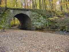
A. This large, disused stone bridge crosses the Patapsco River near Mt.
Airy. It is along an extension of the Mt. Airy Loop that the B&O built
in 1901/02 to connect the Loop with the then new Mt. Airy Cutoff.
The river below is the Patapsco, hardly more than a stream here.
The pipe seen at right discharges effluent from the Mt. Airy waste
treatment plant.
This is a difficult location to reach because a somewhat long and/or
steep hike through brush is needed. The bridge is mentioned in
The Great Road on page 434.
A big "thank you" to all who participated in the contest. We'll
have more contests in the future.
There are more pictures and history of this disused alignment at
the Mt. Airy Loop - East page.
For reference, here was the contest question:
Q. Where can this be found? Look closely: there are sufficient clues here
to uniquely identify this bridge. I believe it to be the largest single-arch
B&O stone bridge anywhere within the area covered by my Photo Tours site.
It is substantial enough to warrant mention in one of
the books on my books page.
To win, correctly identify the:
- B&O branch or line, and
- approximate location on that line, and
- name of stream/river flowing underneath
| 