TrainWeb.org Facebook Page
Washington Branch Photo Tour


B&O Washington Branch
Washington Branch Mysteries

Accompanying each photo below are:

Click a photo to see a larger view. Please send your comments and corrections to Steve.


Unknown1

#1
Mile: 6.0 Date: Sep 2003
Ease: B View: NW
Area: B IC2:
Map: AA 5 J 2, Ho 20 D 13 Topographic Maps

I can figure out the CSX part, but what's the meaning of the ML stamped into the edge of this tie?

Reader Al "sd80macking" Moran reports:

    "Not a direct answer but most of the ties have a 'GS' which stands for Green Spring WVa. I would imagine that ML stands for anothet tie treating place..."

Contributor JD Hiteshew says:

    "I talked to a member of the crews doing the track maintenance, and he said the lettering on the ends of the ties were: CSX-ML represented CSX-Main Line, eight foot ties. We saw one on the site lettered FL-07, CSX ML, and that was Florida, 2007, CSX Main Line, Eight foot ties."


Unknown2

#2
Mile: 7.2, spur Date: Sep 2002
Ease: B View: NW
Area: B IC2:
Map: Ho 20 J 5 Topographic Maps

Some time ago small piles of ballast were dumped at regular distance intervals. Why has not it not been spread evenly? Any reason other than someone forgetting to do so?


Unknown3

#3
Mile: 7.8 Date: Apr 2002
Ease: B+ View: NE
Area: B IC2:
Map: Ho 20 H 7 Topographic Maps

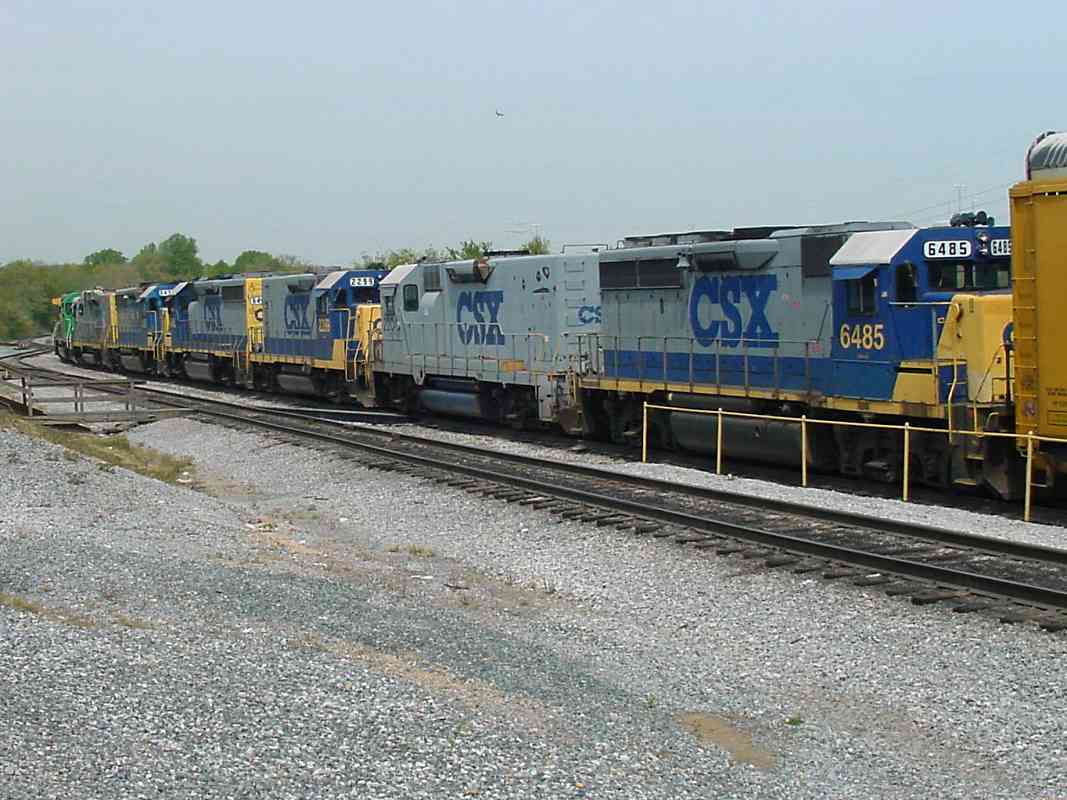
This 8-engine lashup remains the longest I've seen. Why are so many tied together sometimes? It was pulling an ordinary autorack train of the type that at other times keeps only 2 engines busy.

Participating were, in order, CSX 9016, FURX 3042, CSX ?, 6435, 6486, 2299, 2204, and 6485.

Reader Greg Pope replied:

    "Sometimes, railroads attach extra power (sometimes offline) in order to move the units from a yard with extra power to a yard without enough power. Also, units may be shuffled from a yard without maintenance facilities to a yard with maintenance facilities. With most of the units offline, the train really has only the required amount of power online."

Al Moran agrees:

    "All that power is probably being moved to another location for another train. Also, the last 2 are slug sets, not 4 engines but 2. It is not uncommon for power to be shipped, say, from Cumberland (after being shopped) to protect trains in Baltimore or other places..."


Unknown4

#4
Mile: 10.4, spur Date: Jun 2005
Ease: A View: S
Area: A IC2:
Map: Ho 20 B 8 Topographic Maps

My guess is the "Link Belt" artifact near the Bollman Bridge at Savage Mill was used to move cars across the bridge without the need of a switcher locomotive. Anyone know more about it?

Bob McCown sent some details:

    "The mill winched their coal cars around, you can see the winch drum itself back by where the power plant used to be, still with cable on it. They winched because (as you know) the Bollman Truss Bridge wouldn't take the weight of a 20th century locomotive. To make the turns, they had capstan rollers (some still there) placed at the corners to bend the cables around. There is one immediately to the south of the Bollman Bridge, another in what is now the parking lot on the other side."


Unknown5

#5
Mile: 12.0 Date: Oct 2003
Ease: B View: SW
Area: B IC2:
Map: Ho 20 A 13, AA 4 H 13 Topographic Maps

OK, I can figure out the 21, but what are the PW and D signs? Laurel Station is just past the bend.

Reader Charlie Wingate said, of the D sign:

    "It is fallout from the MARC accident in Silver Spring, and tells push-pull trains to approach the next signal (assumed to be absolute) at medium speed. See this link: Bull sheet."

Reader Al Moran adds:

    "The 'D' is to allow passenger trains 40 mph, prepared to stop at the next signal when they stop at a station that the next signal is not visible from. It is similar to a 'DIB' sign in Norac territory and that stands for delay in block. Say they stop at Muirkirk, eastbound. They came in on a clear at Ammendale but now have stopped to let the passengers off. The 'D' allows them to continue at 40 mph, prepared to stop at Cherry Lane. That way if the dispatcher changed the route, he would still have to go into Cherry Lane looking out to stop."

Anyone know about the PW?

Contributor J. D. Hiteshew, Sr. replied:

    "Steve, a friend of mine has two sons that work for railroads, and she says that the PW sign is for 'Passenger Whistle', two long blasts."


Unknown6

#6
Mile: 12.3 Date: Sep 2005
Ease: B+ View: N
Area: B+ IC2:
Map: PG 4 J 3 Topographic Maps

At barely a week old, a GEVO (GE Evolution) unit leads the way west at Laurel, MD. This is the earliest known photo of CSX 5234... it is still wearing the coat of primer applied at the factory. Why didn't GE apply the final paint for the customer?

Reader Al Moran said:

    "GE may have had a back up and/or CSX didn't want to wait for the paint job and elected to use the power at that point so they could return some of the leasers that they have been using for years. NS did the same thing with some of their GEVOs and Dash 9s..."
Greg Pope commented:
    "When railroads rush new units into service without proper paint, this is usually because the railroad does not have enough power available and needs more as soon as possible. When the railroad's power shortage is dealt with, the units are gradually put through the paint shop for their respective coat of paint. As you can see, there are no longer any primer GEVOs on CSX."
This unit would not be painted in CSX livery until the next year.


Unknown7

#7
Mile: 23.4 Date: Apr 2004
Ease: A View: E
Area: B+ IC2:
Map: PG 12 E 2 Topographic Maps

At first glance, does there appear to be grade crossing immediately ahead? Nope, I don't think so either.

The puzzle here is why the town of Riverdale does not do more to highlight its grade crossing. The RR crossing signs are lost amidst a bunch of other signs. The raised gate on the right blends with the utility poles. The pavement of the crossing matches that of immediately adjacent roads that parallel the tracks on both sides.

Not surprisingly, with some frequency confused motorists turn onto the tracks here, get their cars stuck, and thereby present a danger to themselves and others.

Update March 2008: CSX is installing 4-way gates and more warning signals at this grade crossing.


Unknown8

#8
Mile: 24.3 Date: Apr 2004
Ease: A View: NE
Area: B+ IC2:
Map: PG 12 D 5 Topographic Maps

What's the name of this type of car, and for what is it used?

Reader Gregory Hager reports:

    "This type of car is used to transport preassembled track switches. They are carriden standing on their sides as laying them down flat they would be too wide for regular clearances."

This is illustrated by a picture snapped by Dave Hiteshew at Marriottsville on the Old Main Line.


Unknown9

#9
Mile: 25.8 Date: Jun 2004
Ease: B View: NE
Area: C+ IC2:
Map: PG 12 A 8 Topographic Maps

Signals are numbered according to location (milepost), but this pair has an extra digit. Why are these not 348-1 and 348-2?


Thanks for looking.

Return to main page


Copyright Notice