TrainWeb.org Facebook Page
PRR / Amtrak Photo Tour


PRR / Amtrak in Maryland
Modern day photo tour

Accompanying each photo below are:

Click a photo to see a larger view. Please send your comments and corrections to Steve.


Special Note: >>> The places described on this page host quiet, high-speed trains. Stay well clear! <<<

<< Previous (north) | THIS PAGE: Landover to Magruder | Next (southwest) >>

Race To Washington

Race To Washington
Mile: 127.3 Date: Jun 2019
Ease: A- View: N
Area: B+ T6:
Map: PG 13 D 6 Topographic Maps

After staging at New Carollton, Amtrak is first to react to the green on the tree. Amtrak's hauling ten cars compared to Metro's eight.

Metro's X-shaped crossovers, common at terminals such as New Carrollton, maximize flexibility of arrival and departure tracks.

Link: 1970s


Amtrak 635

Amtrak 635
Mile: 127.3 Date: Jun 2019
Ease: A- View: W
Area: B+ T6:
Map: PG 13 D 6 Topographic Maps

It's all relative: maybe this train was standing still while everything else moved past it.


Inspection Car

Inspection Car
Mile: 127.3 Date: Jun 2019
Ease: A- View: SW
Area: B+ T6:
Map: PG 13 D 6 Topographic Maps

The end car of an Amtrak train is often something different, such as a baggage car, or this inspection car. Amtrak has several kinds of inspection cars, but no one has been able to more specifcally ID this one.

Links: reverse view 1970s, 1970s, 1970s


Amtrak 2005

Amtrak 2005
Mile: 127.4 Date: Jun 2018
Ease: A- View: NE
Area: B T6:
Map: PG 13 D 6 Topographic Maps

Northbound AMTK 2005 is slowing to stop at New Carollton, as seen from the site of Ardwick Station, where the grade crossing was supplanted by US 50 around 1960.

Ardwick's larger station building was on this, the northwest side of the tracks, while a small passenger shelter stood southeast of and closer to the tracks.

The cantilever-mounted signal is showing Rule 281b Approach Limited.

Links: 1970s, 1970s, more photos at Todd's site


Amtrak 2008

Amtrak 2008
Mile: 127.4 Date: Jun 2018
Ease: A- View: S
Area: B T6:
Map: PG 13 D 6 Topographic Maps

It's a tight squeeze under US 50. The catenary must be placed with care here since vibrations from traffic on the bridge can cause the power wire to bounce, leading to an electrical short.

Links: ~1980 catenary work, ~1980 catenary work


Low Road

Low Road
Mile: 127.8 Date: Jun 2018
Ease: B View: SW
Area: B T6:
Map: PG 13 C 6 Topographic Maps

MARC can operate at higher speeds than Metro, but will arrive in downtown Washington sooner mostly due to fewer stops. Union Station is MARC's next stop, while a Metro rider endures at least 14 more to get there.

The track on the left, on the ground, serves the Ardwick Industrial Park.


Pennsy Drive

Pennsy Drive
Mile: 128.1 (spur 0.3) Date: Jun 2018
Ease: A View: W
Area: B T6:
Map: PG 13 C 7 Topographic Maps

Along Pennsy Drive the Ardwick Industrial Park spur spans a stream that in standard PG County fashion has been sequestered within concrete. Both the park and its rail service dates to the 1960s, with the latter peaking during the 1970s. Though these rails look unused for some time, they may find new life as the unrivaled efficiency of rail transport becomes part the process to reduce CO2 emissions.


RPCX 1600

RPCX 1600
Mile: 127.8 Date: Jun 2018
Ease: B View: SE
Area: B T6:
Map: PG 13 C 6 Topographic Maps

Yes, the Railroad Passenger Car Numbering Bureau has passenger cars of its own, this of the M500 type, built as a Pullman Standard Comet I coach.

Who numbers the numberers?

Link: RPCX 1600s


Interior

Interior
Mile: 127.8 Date: Jun 2018
Ease: B View: E
Area: B T6:
Map: PG 13 C 6 Topographic Maps

RCPX 1600 information is almost as sparse as passengers on board, but it may have begun life on the Erie Lackawanna Railroad followed by time with New Jersey Transit.


AC Motor Stop

AC Motor Stop
Mile: 127.8 Date: Jun 2018
Ease: B View: SE
Area: B T6:
Map: PG 13 C 6 Topographic Maps

AC Motor Stop advises "motors", as electrically-driven locomotives were first called, to not roll past the sign. In this case the supply catenary soon ends over the near track, the reason for which is explained as this tour continues below.

The line twice spans Beaverdam Branch here via relatively inaccessible bridges that from a distance appear modern.


Landover

Landover
Mile: 128.8 Date: Jun 2018
Ease: B+ View: SW
Area: B- T6: 354
Map: PG 13 A 8 Topographic Maps

During the early 1900s when the PRR replaced the original B&P Station here with an interlocking tower, Landover was not yet a commonly used name for the area, hence the tower borrowed that of a local landowner and became Wilson's Station Railroad Tower, a moniker by which it is sometimes referred even during the 2000s.

Not only has the name survived, but also the tower, albeit in a disused form since the mid-1980s. The new passenger station the PRR built across the tracks (the southeast side) survived into the 1960s, only succumbing upon the arrival of Metro during the 1970s.

Links: MP54 1977, from tower 1977 Conrail coal, CR 4607 1978, GG1 4935 from tower 1978


MARC 7757

MARC 7757
Mile: 128.9 Date: Jun 2018
Ease: B View: N
Area: B- T6: 353
Map: PG 13 A 8 Topographic Maps

The century-plus old Wilson's Station Railroad Tower will likewise succumb should the "Amtrak Parallel Alternative" of the proposed Maglev line be built.

Link: PG County Historic Sites info


Pre-Metro
Photo courtesy Library of Congress

Pre-Metro
Mile: 129.0 Date: 1974
Ease: View: E
Area: B- T6:
Map: PG 13 A 8 Topographic Maps

With the tower at left, this 1974 aerial captured the Metro-izing process underway. Landover Road (foreground) was grade separated during 1941, and twinned in 1959.

Link: LoC source photo


A48866

A48866
Mile: 128.9 Date: Aug 2019
Ease: B+ View: SE
Area: B- T6:
Map: PG 13 A 8 Topographic Maps

Not all Amtrak equipment has steel wheels.


CP Valve

CP Valve
Mile: 128.9 Date: Jun 2018
Ease: B+ View: SW
Area: B- T6:
Map: PG 13 A 8 Topographic Maps

From here to Union Station, track switches are accompanied by these distinctive US&S canister purge valves that are part of the pneumatic system that operates the switch.


Air Pipe

Air Pipe
Mile: 129.0 Date: Aug 2019
Ease: B+ View: NE
Area: B- T6:
Map: PG 12 K 9 Topographic Maps

propped pipe This supply line runs from the tower to the track switches.

Landover became the PRR's most important switching location in the US capital's suburbs when during the first decade of the 1900s the railroad built the Magruder Branch from the mainline here southwest to the then-new Washington Union Station.

This pipeline appears to be part of a second-generation set of switching equipment. Adjacent trackwork during 2019 suggests it will soon turn the job over to a third generation.

Link: 1977


US&S Box

US&S Box
Mile: 129.0 Date: Aug 2019
Ease: B+ View: N
Area: B- T6:
Map: PG 12 K 9 Topographic Maps

Adjacent the second-generation switching equipment is this box dated 1907, probably a remant of the first switch equipment of the Magruder Branch, and the only survivor I've observed along the line.

swissvale Under countless layers of paint it is lettered U.S &.S.Co. SWISSVALE.PA. It's a puzzle why & qualifies for a . but the first S does not. Who knew the circa-1900 rail industry was plagued by cheap designer knockoffs? Later versions of this box omit the . except after Co.

In standard Pennsy cryptic fashion, on its back the box is stenciled SW SLKS.

George Westinghouse of air brake fame founded the Union Switch and Signal Company during the 1880s. Swissvale, Pennsylvania was the home to the company's primary factory from 1881 to 1985. Today US&S is a subsidiary of global rail control equipment maker Ansaldo STS.

Link: track diagram


Magruder Branch

Magruder Branch
Mile: 128.9 Date: Jun 2018
Ease: B View: SW
Area: B- T6:
Map: PG 13 A 8 Topographic Maps

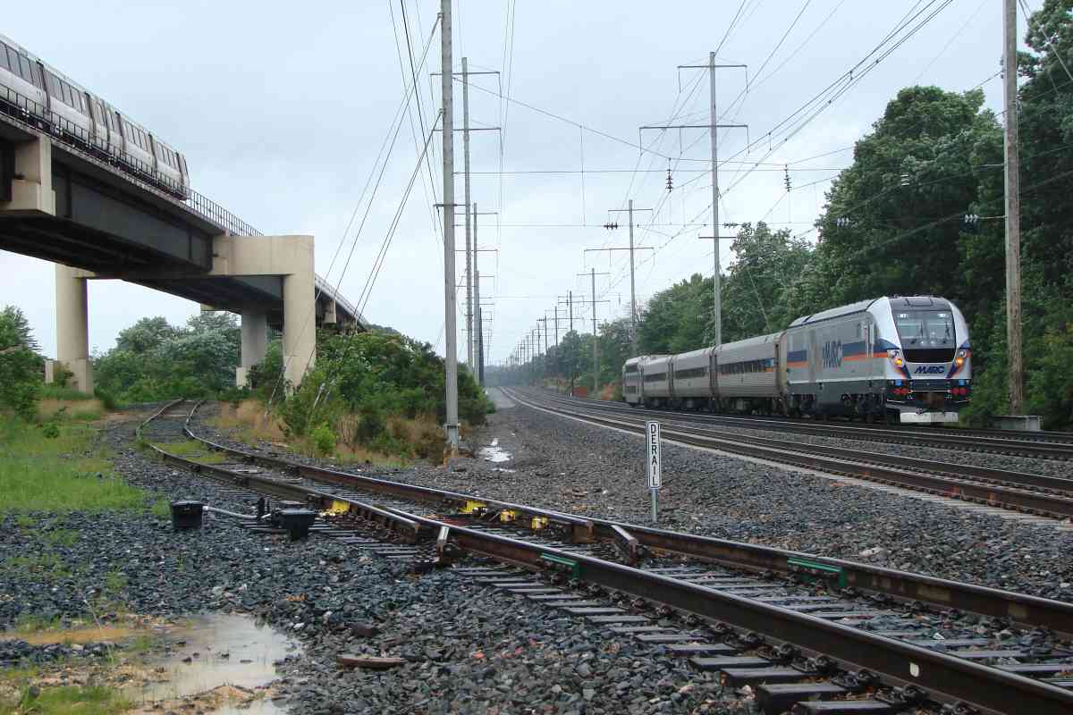
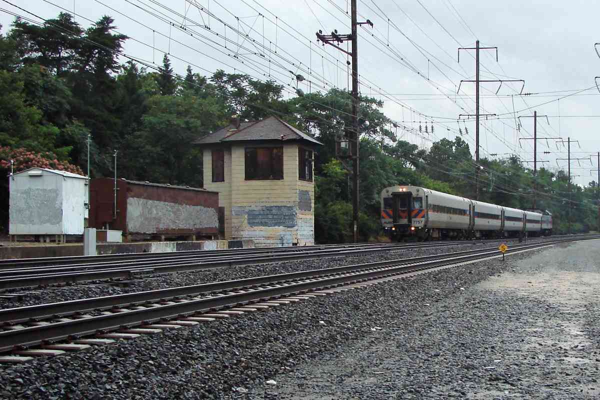
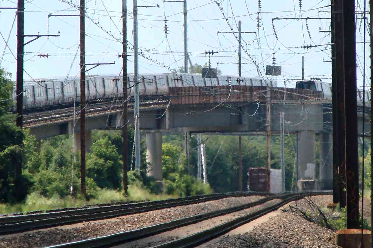
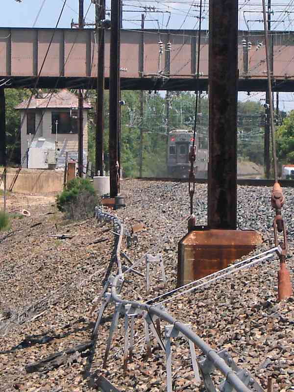
This MARC train bound for Washington is following the Magruder Branch. 
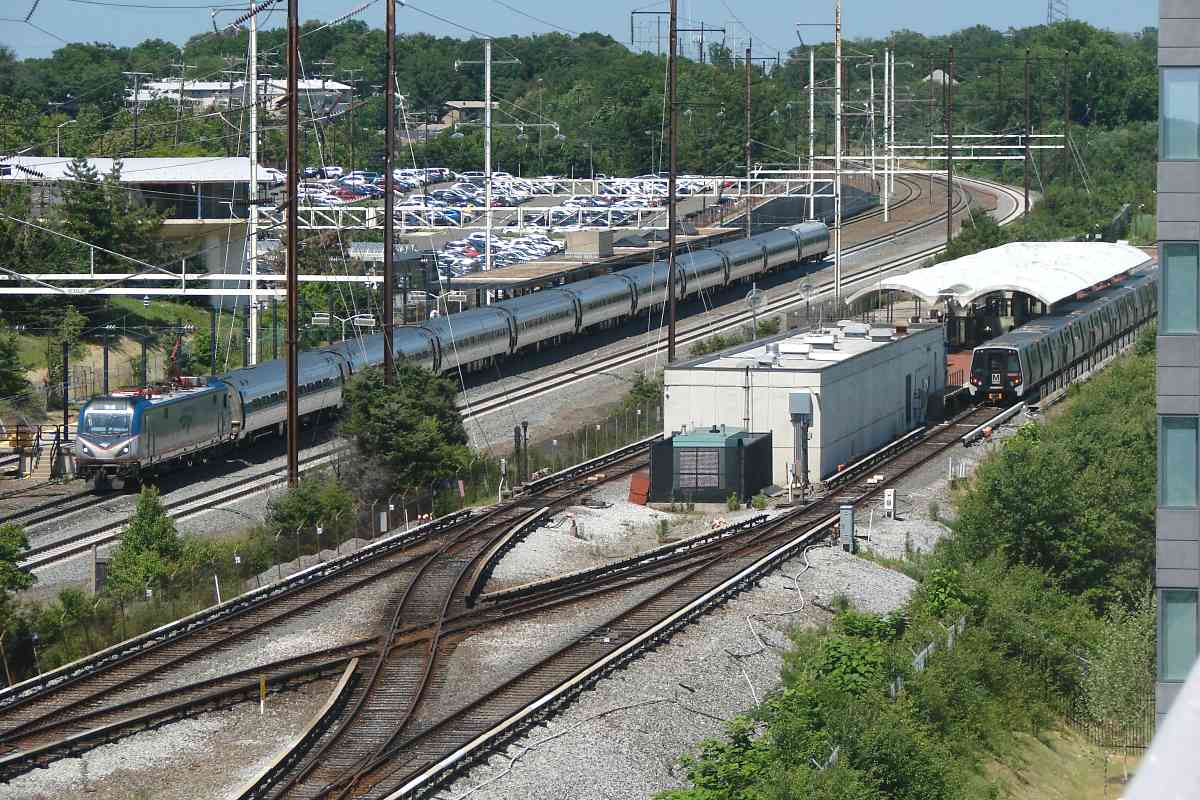
The tracks on the left are the ex-B&P mainline to Washington, now used by CSX.

1878 map 
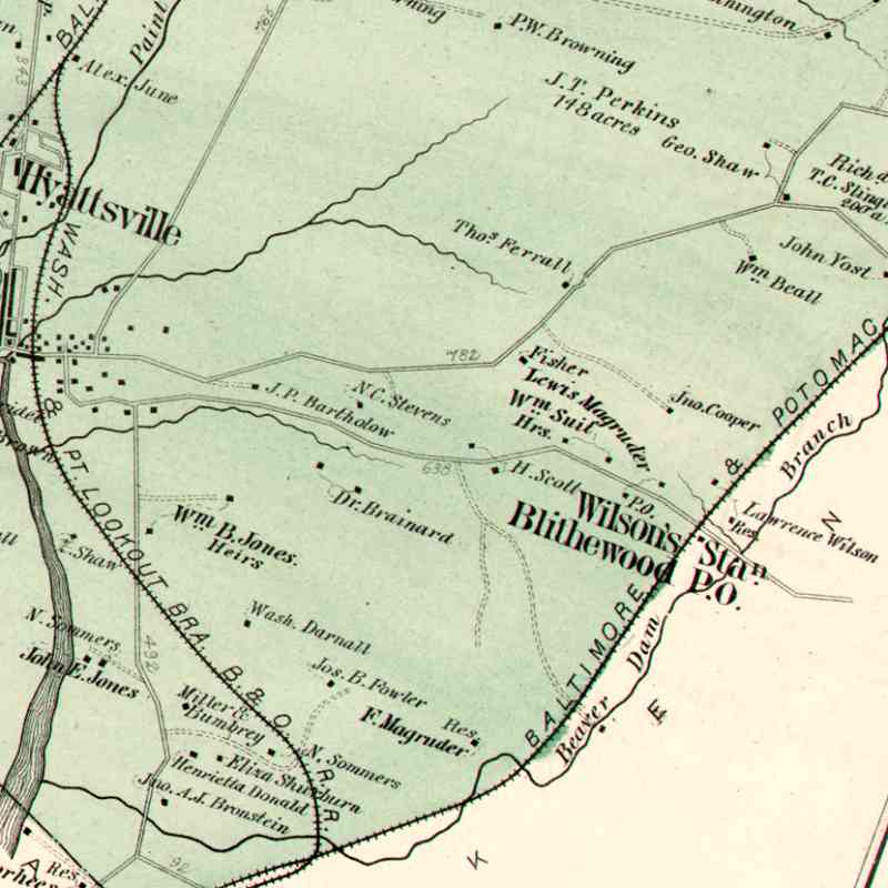
This area had been known as Magruder. A Hopkins 1878 map shows Lewis Magruder, and F. Magruder, likely relatives of the family associated with the Magruder grocery chain in Washington. Before Landover this area was known as Wilson's Station, and Blithewood Post Office.

The map's rail line marked "Wash. & Pt. Lookout Bra. B&O" began in 1872 as an independent rail company, but was quickly acquired by the B&O to do an end run around the Pennsy's B&P end run into Washington that gave the PRR control of Long Bridge to Virginia. For awhile the line was known as the B&O's Baltimore, Washington and Alexandria Branch of the Washington City and Point Lookout Railroad. Fortunately, that was later shortened to Alexandria Branch.


Metro

Metro
Mile: 129.0 Date: Aug 2019
Ease: B+ View: SW
Area: B- T6:
Map: PG 12 K 9 Topographic Maps

Metro plays hopscotch with the B&P/PRR original route where a distant boxcar waits for a ride (left). After the Magruder Branch (right) became the main line PRR renamed the original route the "Landover to South End". Ownership passed to Conrail, then during 1999 to CSX for which it is the Landover Subdivision.


<< Previous (north) | THIS PAGE: Landover to Magruder | Next (southwest) >>

Or, return to main page

Copyright Notice