TrainWeb.org Facebook Page
Old Main Line Photo Tour


B&O Old Main Line
OML Mysteries

Accompanying each photo below are:

Click a photo to see a larger view. Please send your comments and corrections to Steve.


Unknown1

#1
Mile: 0.4 Date: May 2000
Ease: B View: NW
Area: B IC2:
Map: Ba 42 H 1 Topographic Maps

These relics had stood just west of the B&O Museum at Baltimore. What had they been?

Reader Jim Kelling reports:

    "According to B&O Museum personnel, this was the tender repair shop in the steam era."


Unknown2

#2
Mile: 0.5 Date: May 2002
Ease: B View: E
Area: B IC2:
Map: Ba 42 H 2 Topographic Maps

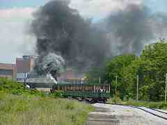
From its stack, a given steam engine sometimes output mostly thick black smoke, sometimes thin black smoke, and sometimes white smoke. What accounts for the different smoke colors?

Reader Mark Roberts answers:

    "In theory, burning coal should generate remarkably little byproduct except water vapor and carbon dioxide. After all, the coal is just made up of hydrocarbons. In reality, there are a few other impurities mixed in with coal. These are pretty minor and should rarely be seen. Some coal is more impure than others.

    "White exhaust is steam-- water vapor.

    "Black exhaust is unburned coal particles and steam. It indicates that a lot of coal has been piled on to the fire or that the fire is not burning properly. This can be caused by a variety of reasons; not cleaning out the ashes, not enough air, too much coal, etc. It is analogous to a gasoline engine running rich.

    "By adjusting the controls carefully the fireman can maximize the combustion of the coal. A properly-fired engine has a light gray exhaust."


Unknown3

#3
Mile: 6.6 Date: Jul 2004
Ease: A View: W
Area: B+ IC2:
Map: Ba 41 J 12 Topographic Maps

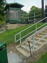
Like a long forgotten scepter, this rusty pole at the base of the steps at the St. Denis MARC commuter station had once served some purpose. What was it?

Contributor JD Hiteshew reports:

    "I talked to an oldtime railroader who said the contraption at the base of the steps was a gas vent. What, where, and why there was gas, he didn't have any idea."


Unknown4

#4
Mile: 6.6 Date: Oct 2004
Ease: A View: W
Area: B+ IC2:
Map: Ba 41 J 12 Topographic Maps

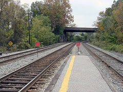
Also at St. Denis, red signs stand at the end of the platform. What do they signify?

Reader Al Moran answers:

    "The red signs signify the start of a work authority, one for each track. When a track gang or maintenance gang is working, these signs are at the point where the authority begins. They are preceded by a yellow sign with a red diagonal stripe about 2 miles before the work area begins. They are usually referred to as 'red boards'..."


Unknown5

#5
Mile: 7.1 Date: Jun 2001
Ease: B View: NE
Area: B IC2:
Map: Ba 41 H 12 Topographic Maps

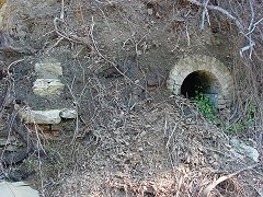
This brick arch is embedded within the rock face at Relay across from where B&O's hotel had stood. What purpose did it have?

Contributor JD Hiteshew reports:

    "I believe the brick structure is a natural spring. Dave and I found another one, very similar, about forty feet up the hill at Lee's coaling tower just East of Ellicott City. "


Unknown6

#6
Mile: 9.5 Date: Jun 2001
Ease: B View: NW
Area: A IC2:
Map: Ba 41 H 8 Topographic Maps

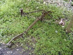
Before the Heritage Greenway Trail was added in Patapsco State Park, this rusty object sat trackside for years. Did it fall from a train? Can you identify it?

Reader Deerhuntnfanatic says:

    "I would say that what you are looking at is the remnants of old brake rigging from perhaps an old derailment."

Reader Dave Manning agrees:

    "#6 is definitely a brake beam and linkage from a freight car truck. The brake beam is the bow shaped triangular part at top. There is a brake shoe on each end and the beam is suspended between the wheels on each side of the truck bolster. The parts extending down from the beam towards the lower left are the levers that attach the beam to the car's brake system, specifically the brake rods, levers, and slack adjuster. All of which is attached to the brake cylinder."


Unknown7

#7
Mile: 10.5 Date: Oct 2004
Ease: B View: S
Area: A IC2:
Map: Ba 41 H 8 Topographic Maps

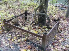
The rusty object was not far from Bloede Dam. Is it a railroad artifact?

Reader Andy Larowe answers:

    "It is a common 'foundrybasket' or 'tote' for semi-finished castings and other metal parts-stampings, etc. My guess is that it held spike plates during rail repair."


Unknown8

#8
Mile: 19.7 Date: Nov 2003
Ease: C+ View: NW
Area: A IC2:
Map: Ho 11 K 0 Topographic Maps

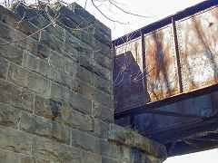
The stones found in many of the abutments of the OML's circa 1900 bridges exhibit circular pockmarks. Is this a relic of the quarrying technique?

Reader Mark Roberts explains:

    "Quarrying techniques usually involve the drilling of holes for a variety of reasons. One of the most common reasons is for the packing of explosives. Other reasons are to direct the line of fracture or to insert a wedge. At some quarries, water or even air is forced into holes drilled into rock in order to break it up for removal. Thus, these holes are very likely to be the result of quarrying techniques."
Bob Netzlof kindly wrote to add an observation and explanation:
    "I once saw a PRR blue print showing how to handle stone blocks. They used tongs on a crane. The points of the tongs fit into the little craters thus giving a more secure grip than one would get by simply bringing the points against the stone surface.

    "If you look at #8, you'll see that most of the cavities are at the longitudinal center of the block and well above the horizontal center. That would allow the block to hang level as it was moved into position on the wall.

    "So, rather than being a relic of some quarry operation, the pock marks are made deliberately to facilitate handling the blocks, both at the quarry and at the job site."


Unknown9

#9
Mile: 25.1 Date: Sep 2005
Ease: B View: N
Area: C+ IC2:
Map: Ca 35 K 6 Topographic Maps

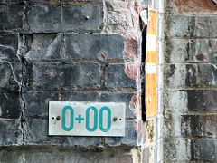
0+00 sounds like the start or end of something. What does it mean?

Contributor JD Hiteshew reports:

    "They are distance measurements used by surveyors.

    "The basic unit of measurement used by surveyors is the 'Station', equal to 100 feet, exactly. Smaller lengths are the 'Pluses', notated as +55.63, which means 55 feet and 63/100 of a foot.

    "The beginning of the survey can be any arbitrary value (0+00, 3+00, 10+00, or whatever ) and the tunnel, which has a fixed beginning, would generally be 0+00, and the end of the tunnel, as surveyed, might be 4+23.78. The sticker 4+00 is value for the point exactly 400 feet from the start, but where that point is located should be indicated nearby, and sometines the center of the plus ( + ) sign is the point referenced.

    "In surveying roadwork, 0+00 can be used for the beginning of the Survey, but is not recommended, since the start of the project may be altered, usually backwards, causing the need to use negative numbers. The better approach is to sta rt the survey numbering with 10+00, 50+00, or even 100+00.

    "Complex road projects, like interchanges, will start each new roadway (mainline and ramp) with a new number set, i.e. 100+00, 110+00, 120+00, to avoid the possibility of negative values, and to avoid different parts of the survey having the exact same number series, since the series increment is 10,000 feet, or nearly 2 miles."

Link: survey "chaining" in NYC subway

Unknown10

#10
Mile: 26.1 Date: Aug 2002
Ease: C View: NE
Area: A IC2:
Map: Ca 35 G 6 Topographic Maps

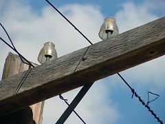
The Porter Plastic Insulator is the most common insulator found atop the OML's utility poles. To my knowledge, these wires were disused around 1980, which means many of these insulators are at least 30+ years old, and likely much older. How do plastic insulators survive the harsh outdoor conditions without cracking and falling apart? If this material is so tough, why it is not used for things like roofing shingles?


Unknown11

#11
Mile: 30.1 Date: Jul 2001
Ease: B+ View:
Area: A IC2:
Map: Ca 35 G 5 Topographic Maps

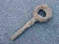
CSX trackwork at Gaither had unearthed this roughly foot-long artifact. Might this be a coupler pin surviving from before the introduction of knuckle couplers?


Unknown12

#12
Mile: 34.4 Date: Mar 2005
Ease: B View: E
Area: A IC2:
Map: Ca 33 F 4 Topographic Maps

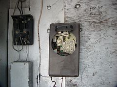
When did train crews last employ telephone (rather than radio) communications along the OML? I had thought it was around 1970. The relic in this box suggests a later date was possible: the touch tone design had only been introduced in the 1960s and did not see wide use until the 1970s.

In 2009 I saw mention that the trackside phones were used until about 1980 because it was not until then that repairs were completed for the damages to the OML's signalling system from the floods of 1972's Tropical Storm Agnes.

The scribblings suggest the "phone number" for HX Tower (Halethorpe) had been 49 and that for WB Tower (Brunswick) was 92.


Thanks for looking.

Return to main page


Copyright Notice