TrainWeb.org Facebook Page
Old Main Line Photo Tour


B&O Old Main Line
Old Main Line via Satellite

Accompanying each photo below are:

Click a photo to see a larger view. Please send your comments and corrections to Steve.

White Ties
Photo courtesy Google

White Ties
Mile: 9.8 Date: Apr 2007
Ease: View:
Area: IC2:
Map: Ba 41 B 8, Ho 17 D 1 Topographic Maps

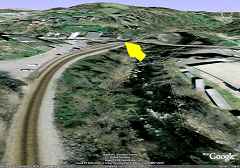
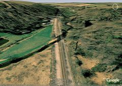
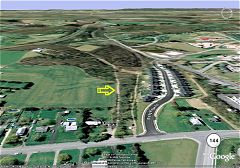
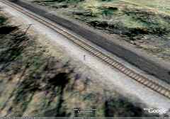
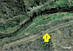
Whitewashed track ties show up surprisingly well in the satellite images (click the thumbnail for the larger view). Such ties indicate something passes under the tracks, most often a culvert, and three are visible in this image. The yellow arrow points to the one closest to the Patapsco Park's Swinging Bridge. If you wish to hunt for possible locations of relics like arched stone bridges and culverts, this is the easiest way to find them.


On-Location
Updated Dec 2009

On Location
Mile: 9.8 Date: Feb 2009
Ease: B View: SW
Area: A IC2:
Map: Ba 41 B 8, Ho 17 D 1 Topographic Maps

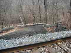
This photo was snapped from the trackside location of the yellow arrow of the prior image. The whitewashed tie is at the bottom right corner looking less white than I would have expected. The stonework adjacent to the tracks had been part of the Orange Grove mill,a chute into the mill to offload from cars above.

Reader Robb Bailey contributed details:

    "The chute is located above where the Corliss steam engine was once located in the mill complex, so the chute would have accomodated coal, not grain. Morever, the mill burned in May 1905, long before grain was carried in hoppers. Grain was transported in box cars at the time the mill was in operation. Period photos of the mill in operation clearly show box cars behind the mill complex."


Perspective
Photo courtesy Google

Perspective
Mile: 9.8 Date: Apr 2007
Ease: View: SW
Area: IC2:
Map: Ba 41 B 8, Ho 17 D 1 Topographic Maps

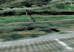
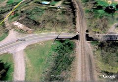
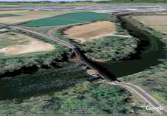
The Google Earth program can stretch the satellite image into a perspective view. This example replicates the view of the on-location photo above.

Google Earth knows the terrain elevation, and drapes the flat satellite image over it, thereby simulating hills and valleys. The program does not know what sticks out of the ground (like trees) or what is above the ground (like the Swinging Bridge) hence such items appear as if they've been squashed flat. After you see enough perspective views, you get comfortable with everything looking flat, and can mentally adjust.


Culvert

Culvert
Mile: 9.8 Date: Feb 2009
Ease: B View: W
Area: A IC2:
Map: Ba 41 B 8, Ho 17 D 1 Topographic Maps

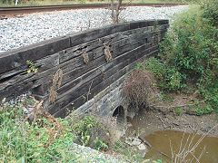
Here's the inlet side of the box culvert the white tie is indicating. There is mortar on the inside that leads me to believe this is not an original cira 1830 culvert, but rather one rebuilt later for the mill. One unusual thing is I have not found the outlet side of this culvert. Its water may have been redirected for mill purposes.

Frequent contributor Dave Hiteshew writes:

    "We have also searched for the outlet for that culvert. It is virtually buried now, but it is low in the stone wall that the swinging bridge lands on. Also, it is partially behind that sewage pipe. Glimpses of it can be seen in older pics when the water was up against the wall. After a few rainy days, it's easy to see water bubbling out under that sewage pipe where the culvert discharges. It's about 30-40 ft. east of the bridge."


Bloede Dam
Photo courtesy Google

Bloede Dam
Mile: 10.5 Date: Jul 2009
Ease: View: N
Area: IC2:
Map: Ho 13 B 13 Topographic Maps

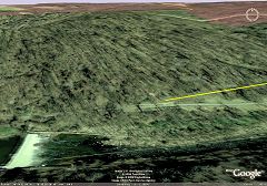
This perspective view shows Bloede Dam at bottom left. Above the yellow line are the tracks that lead to the hill-piercing Ilchester Tunnel. The yellow line shows the OML's original alignment; below it is the Grist Mill Trail extension where a row of the B&O's granite stringers have been pulled up and put on display.


Ellicott City
Photo courtesy Google

Ellicott City
Mile: 12.7 Date: Apr 2007
Ease: View: NW
Area: IC2:
Map: Ho 12 G 10 Topographic Maps

The yellow arrow points to the B&O's Ellicott Mill's station. The flour mill buildings on the right are as flat as a pancake made with their products.

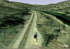
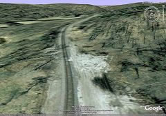
As you may realize, in reality, the track does not lean as shown here, nor does it rise and fall. While the elevation information database nicely depicts the Patapsco Valley's hills, it lacks the resolution to precisely show every detail. Should you prefer, the Google Earth program lets you turn off the terrain elevation feature.


Signal
Photo courtesy Google

Signal
Mile: 15.6 Date: Apr 2007
Ease: View: NW
Area: IC2:
Map: Ho 12 H 4 Topographic Maps

In some ways the depictions remind me of a model railroad. I'm reasonably certain that's a signal and accompanying shadow at bottom center. Just beyond is the white tie of another culvert.


Daniels
Photo courtesy Google

Daniels
Mile: 18.1 Date: Apr 2007
Ease: View: N
Area: IC2:
Map: Ho 12 D 1 Topographic Maps

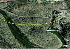
The satellite pictures can be helpful for researching old alignments. The second B&O alignment at Daniels cut across the Patapsco River twice, as shown by the yellow line, and left an indentation across the hillside.


Dorsey Tunnel
Photo courtesy Google

Dorsey Tunnel
Mile: 19.1 Date: Apr 2007
Ease: View: N
Area: IC2:
Map: Ho 12 A 1 Topographic Maps

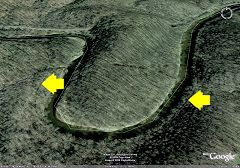
It wasn't until 1906 that the Dorsey Tunnel (top) was bored through a tongue of land so as to eliminate a sharp curve on the near side of the river. Yellow arrows point to the alignment disused for over a century, but still visible.


Stuff
Photo courtesy Google

Stuff
Mile: 26.0 Date: Apr 2007
Ease: View: W
Area: IC2:
Map: Ca 35 G 6, Ho 5 G 7 Topographic Maps

What's all this white stuff near mp 26? I'm thinking it may be related to a 2006 derailment in this vicinity.


Cutoff
Photo courtesy Google

Cutoff
Mile: 35.9 Date: Apr 2007
Ease: View: W
Area: IC2:
Map: Ca 33 B 3, Ho 3 C 4 Topographic Maps

That in the past the tracks stayed on the north (right) side of the Patapsco Rover is fairly evident by the scars that remain. This is the eastern end of the Mt. Airy Cutoff. On location picture


Train
Photo courtesy Google

Train
Mile: 38.8 Date: Apr 2007
Ease: View:
Area: IC2:
Map: Ca 32 E 4, Ho 2 E 6 Topographic Map

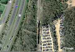
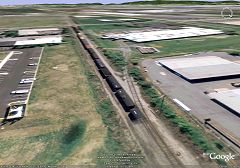
Looking top down for a change, sometimes the satellite will even catch a train in progress. This location is about a mile east of Mt. Airy. A junkyard occupies the land between the current alignment, and the B&O's original. The junked cars at right sit near the top of Plane 1.


Plane 3
Photo courtesy Google

Plane 3
Mile: 40.0 Date: Apr 2007
Ease: View: W
Area: IC2:
Map: Ca 32 A 4, Fr 42 B 2, Ho 2 A 5 Topographic Maps

One might expect the satellite pictures to be great for tracing the route of B&O's inclined planes over Parrs Ridge and Mt. Airy, however both time and the eraser of development have obliterated most of the route. Only Plane 3 survives in readily identifiable form, pointed to by the yellow arrow. The veer ahead to the left is not original; it was added later as a utility road after the Plane had been disused. On location picture


Monrovia
Photo courtesy Google

Monrovia
Mile: 46.2 Date: Apr 2007
Ease: View: W
Area: IC2:
Map: Fr 40 G 1 Topographic Maps

Something I only realized just now: the bridge over MD 75 at Monrovia is not wide enough for double track. That means it must have been rebuilt sometime after the B&O converted the OML to single track in the 1950s. This is another example of the kind of detail that can be gleaned from satellite pics.

The yellow line at left marks the original circa 1830 alignment.


Whistle Post
Photo courtesy Google

Whistle Post
Mile: 46.4 Date: Apr 2007
Ease: View: NW
Area: IC2:
Map: Fr 40 F 1 Topographic Maps

At center, this whistle post as seen from space.


Wood
Photo courtesy Google

Wood
Mile: 47.6 Date: Apr 2007
Ease: View: E
Area: IC2:
Map: Fr 40 C 1 Topographic Maps

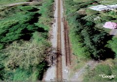
The satellite views look downward and only slightly sideways, consequently they provide only glimpses of the side of a structure. Thus rarely do they show enough to reveal the construction style (stone arch, box, pipe) of a bridge/culvert. Here, the dark line parallel to the tracks are wooden ties above the culvert. The yellow arrow points to a white fiber optic line marker.


Side

Side
Mile: 47.6 Date: Sep 2005
Ease: C View: E
Area: A IC2:
Map: Fr 40 C 1 Topographic Maps

A similar on-location view allows us to better see the side, and to learn this is a piped culvert dating to the circa 1900 construction of the Mt. Airy Cutoff. Why the stonework was not continued higher is a puzzle. Perhaps a later regrading raised the tracks, and the wood was added to hold back the ballast. At top left is the white fiber optic line marker.


Monocacy River
Photo courtesy Google

Monocacy River
Mile: 53.9 Date: Apr 2007
Ease: View: NW
Area: IC2:
Map: Fr 38 J 1 Topographic Maps

Who knew the B&O had a rollercoaster at the Monocacy River? Ahead at left is the Frederick Junction wye.


Muffins
Photo courtesy Google

Muffins
Mile: 55.9 Date: Apr 2007
Ease: View: SW
Area: IC2:
Map: Fr 38 E 3 Topographic Maps

Either two images have been sewn together here, or we've learned that invisibility cloaks can be picked up at the Thomas' English Muffin siding.

Many active sidings peel off into this commercial area south of Frederick along MD 85, Buckeystown Pike. The satellite images make it easy to see where each siding leads.


Alcoa
Photo courtesy Google

Alcoa
Mile: 59.2 Date: Apr 2007
Ease: View:
Area: IC2:
Map: Fr 37 G 8 Topographic Maps

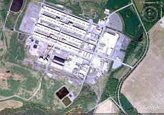
The sprawling Alcoa Aluminum factory can be captured from above. The Old Main Line runs east-west parallel to the bottom of this image, but off screen. Up from it comes a half-mile long spur that splits into many sidings at the factory.


Double Track
Photo courtesy Google

Double Track
Mile: 61.5 Date: Apr 2007
Ease: View: SW
Area: IC2:
Map: Fr 44 D 1 Topographic Maps

Just west of the Doubs Road grade crossing, a leftover segment of rail illustrates the OML's double track configuration.


Point of Rocks
Photo courtesy Google

Point of Rocks
Mile: 64.5 Date: Apr 2007
Ease: View: SW
Area: IC2:
Map: Fr 43 H 5 Topographic Maps

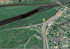
The OML meets the Metropolitan Subdivision (left) at Washington Junction. The yellow arrow points to the B&O's Point of Rocks station, which remains in use for MARC commuters.


Thanks for looking.

Return to main page


Copyright Notice