TrainWeb.org Facebook Page
B&O Photo Tour


B&O Marley Neck Branch
Modern day photo tour

Accompanying each photo below are:

Click a photo to see a larger view. Please send your comments and corrections to Steve.


<< Previous (west) | THIS PAGE: Cabin Branch to Arundel Cove | Next (east) >>

Map

Map
Mile: Date: (Apr 1964)
Ease: View:
Area: IC2:
Map: Ba 43 Topographic Maps

The Marley Neck Branch mileposts decline numerically as the route weaves generally east. This Part 2 tour page starts at top left and finishes at the end of the spur at bottom right of this map. Aerial photos courtesy Johns Hopkins University.


Aerial 1927

Aerial 1927
Mile: Date: 1927
Ease: View:
Area: IC2:
Map: AA 3 E 6, Ba 43 A 12 Topographic Maps

On the right, bridge 7B rises over the Marley Neck Branch track in this 1927 aerial photo. With vehicular traffic minimal by current standards, the justification for a bridge must have been to reduce the chance of a train - petrochemical truck collision.

Note the siding that peels left into the tank farm; it is now an access road within the farm.


Bridge 7B

Bridge 7B
Mile: 5.1 Date: Jun 2015
Ease: B View: S
Area: C+ IC2:
Map: AA 3 E 7 Topographic Maps

The roughly century-old bridge is still extant, but is no longer climbed... except by vines. Aerial photos suggest it was decommissioned during the 1960s. This design was popular during the early 20th century but only a few remain extant now.


Crumbling

Crumbling
Mile: 5.1 Date: Jun 2015
Ease: B View: S
Area: C+ IC2:
Map: AA 3 E 7 Topographic Maps

rust Given its deterioration, I am surprised the bridge is still here. Perhaps there is disagreement whether it is the railroad's responsibilty or that of the adjacent landowner.

If one of them does not take it down, eventually gravity will do the job.


Milepost 5

Milepost 5
Mile: 5.0 Date: Jun 2015
Ease: B View: S
Area: C+ IC2:
Map: AA 3 E 7 Topographic Maps

Sometimes pipes go under the tracks, sometimes over, possibly depending on what substance is being moved. Ahead a red van rides atop the Baltimore Beltway.

The Clearance label (22 feet, 8 inches) must reflect a regulation since it serves little purpose: no train operator will be able to read it and stop in time. Perhaps it makes the operator more secure knowing a train will fit under.


Active Siding

Active Siding
Mile: 4.9 Date: Jun 2015
Ease: A- View: N
Area: C+ IC2:
Map: AA 3 F 7 Topographic Maps

track map Those pipes connect with the facility at this siding. This siding is active and well-maintained with proper signage, derail, access controls, etc.

There's even a track layout diagram, the white board in the zoom view.


Ordnance Road

Ordnance Road
Mile: 4.8 Date: Jun 2015
Ease: B+ View: S
Area: C+ IC2:
Map: AA 3 F 7 Topographic Maps

At Ordnance Road, one finds the rare combination of a grade crossing under an Interstate-signed highway. Though signed I-695, this 20-mile southeast section of the Baltimore Beltway is officially Maryland 695.

The rusty siding on the right leads into a US Army General Services Depot that has been fallow for decades. The Depot's buildings appear in a 1927 aerial photo.


View South

View South
Mile: 4.7 Date: Jan 2015
Ease: B+ View: S
Area: C+ IC2:
Map: AA 3 F 7 Topographic Maps

The utility poles on the right follow the now-dimantled siding within the US Army General Services Depot, terminus of the Marley Neck Branch during the 1920s. Currently, the branch continues past the depot and curves left (east).


Around the Bend

Around the Bend
Mile: 4.3 Date: Mar 2015
Ease: B View: E
Area: B- IC2:
Map: AA 3 G 8 Topographic Maps

Beyond the curve stands the Curtis Creek Swing Bridge guarded by one of the last remaining operational B&O color-position light signals. It'll take an act of Congress to replace it with a newer design. That's no joke: there's so much federal activity around here that to simply repair rail ties during February 2015 CSX needed a governmental OK to close the bridge outside regular schedule.

Link: Federal Register


CPL 2

CPL 2
Mile: 4.2 Date: Mar 2015
Ease: B View: E
Area: B- IC2:
Map: AA 3 G 8 Topographic Maps
4 lamps

By convention, all numbered signals controlling eastbound trains end in an even digit, all westbound in an odd digit.

Screens cover signals in areas with a high rate of vandalism. Since this location is relatively quiet, I suspect the critical nature of the signal warrants the screen: locomotives don't operate as well under water.

This CPL exhibits an uncommon 4-lamp arrangement: essentially either Stop or Go.


Swing Bridge

Swing Bridge
Mile: 4.1 Date: Mar 2015
Ease: B- View: E
Area: B- IC2:
Map: AA 3 G 8 Topographic Maps

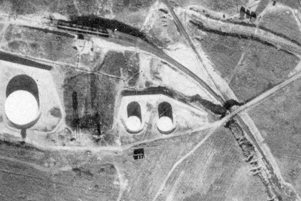
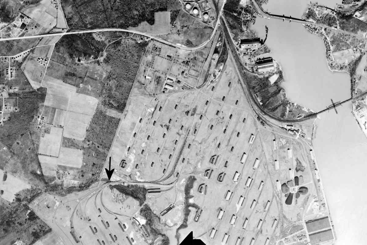
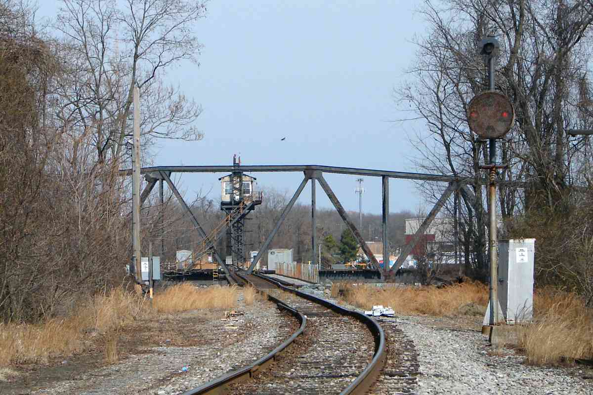
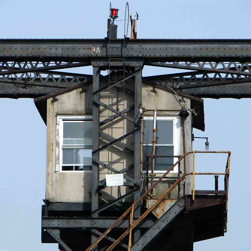
Though some refer to it as a drawbridge, the proper term for this structure along Curtis Creek at Stahls Point is a swing bridge. Drawbridges raise 
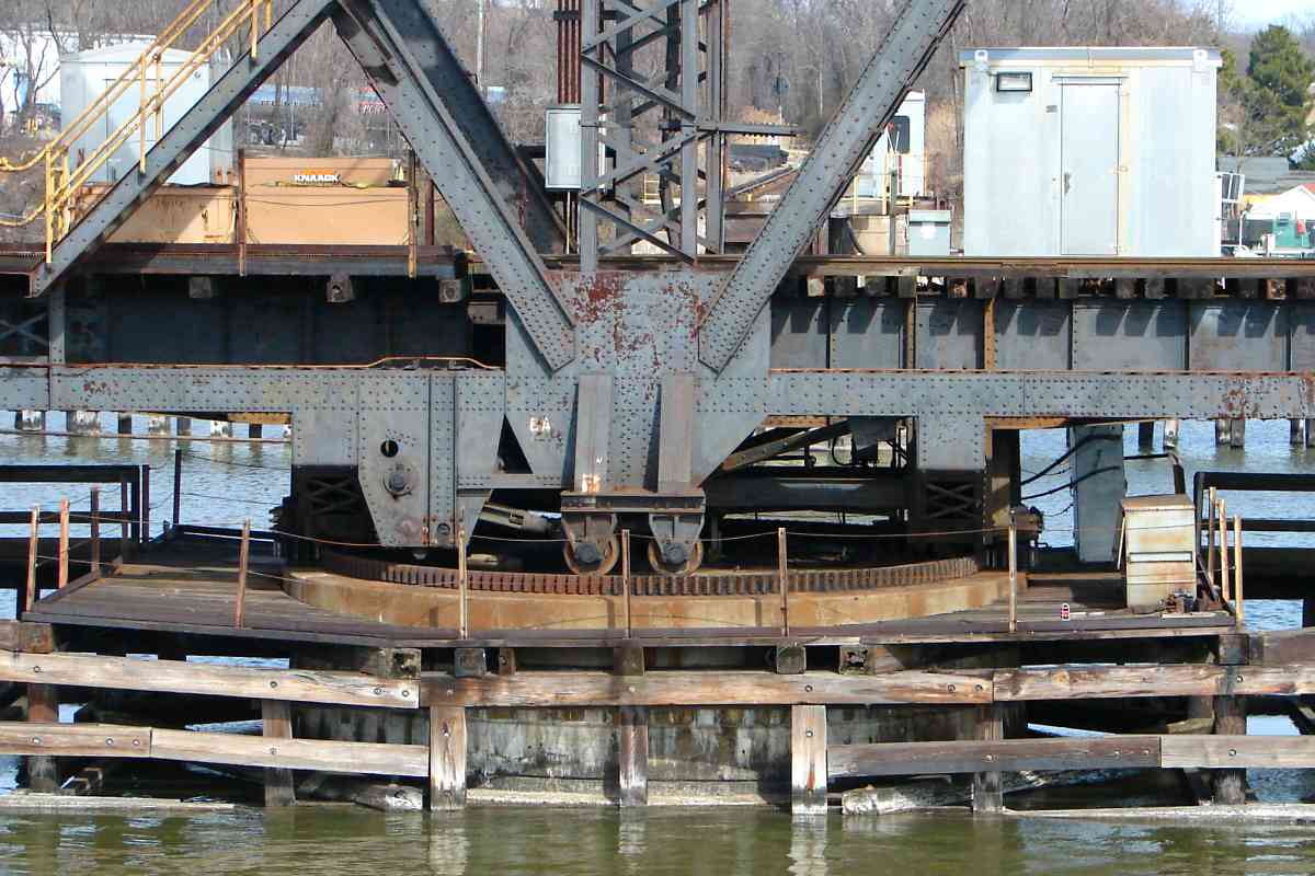
and lower a section, but this bridge turns on a central pivot to swing its rails to meet those stationary. closed

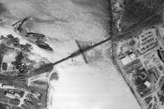
This is one of only two operational swing bridges in the Baltimore 
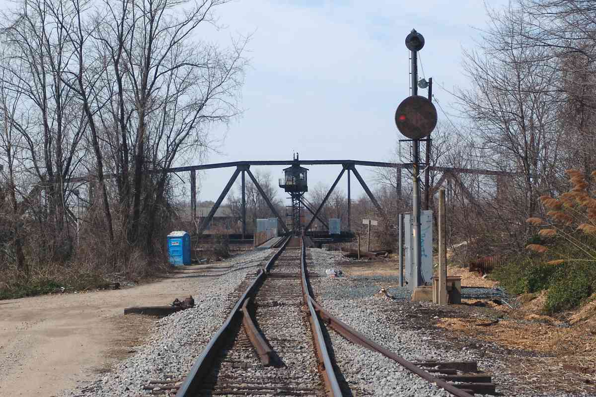
area. The bridge remains in the open position except when trains need to cross, or for repair. When closed, the bridge is 13 feet 
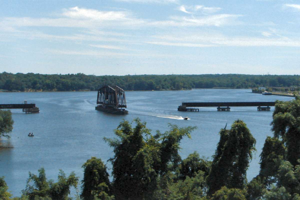
above the mean height of the water. The aerial photo at right happened to capture the bridge in the closed position while a train was crossing April 10, 1964.

Links: Bridgehunter, kayaking, kayaking, video of Lewes, Delaware swing bridge


Hut

Hut
Mile: 3.8 Date: Mar 2015
Ease: C View: E
Area: B IC2:
Map: AA 3 G 8 Topographic Maps

At times the hut above the center of the bridge is manned as if a railroad tower.

Al Grimes, who operated this swing bridge during the 1960s, kindly shared memories:

    "All bridges were operated by interlock operators. Many, like myself were qualified on several towers. All freight at my time was second shift. Generally one or two long trains over and back each night. Operators would park at the coast guard yard... walk the tracks to a remote box, sound a marine warning, then swing the bridge so we could climb on.

    "The hut on top was a small office, desk and a series of manual pull levers to extend the track over the bridge gap. Cold weather was a workout... electric contacts had to be made. We had a large control board showing trains coming. End of shift... close bridge to get off,... then open it remotely for boat traffic. The old electric motor would break down every now and then... but it was fun work, and different from other tower jobs!"


Wheels

Wheels
Mile: 3.8 Date: Mar 2015
Ease: C View: E
Area: B IC2:
Map: AA 3 G 8 Topographic Maps

ospreys At the central pier, much of the weight of the bridge, numbered 8A, is supported by heavy-duty wheels and mechanisms.

Marley Neck Branch mileposts 3 and 5 are only 1.75 miles apart. If number 4 were posted, it would be near here at Curtis Creek. I suspect the creek threw off measurements, leading to a missing quarter mile.

Up above, this nesting pair of Osprey are more concerned about missing lunch.


From MD 695

From MD 695
Mile: 3.7 Date: Aug 2015
Ease: A View: S
Area: B IC2:
Map: Ba 43 B 13 Topographic Maps

drawbridges The swing bridge, built around 1940, is readily visible from the Baltimore Beltway that opened here during 1977. The Beltway spans the creek via dual drawbridges, as does adjacent Hawkins Point Road / Pennington Avenue, seen at right undergoing maintenance during July 2011.

Above note the wide supports where the railroad's swing bridge ends will meet the track from land. When the bridge turns into place it locks into those supports. Without them, when a heavy locomotive rolled onto its track the swing bridge would tip over like a see-saw.


Looking Back
Photo courtesy Dave Hiteshew

Looking Back
Mile: 3.6 Date: Mar 2008
Ease: B- View: W
Area: B IC2:
Map: AA 3 G 8 Topographic Maps

Now we're looking back from the east side but symmetry hides that fact.


CPL 1
Photo courtesy Dave Hiteshew

CPL 1
Mile: 3.5 Date: Mar 2008
Ease: B- View: W
Area: B IC2:
Map: AA 3 H 8 Topographic Maps

As was true on the west side, a CPL and derail protect the bridge.

The empty concrete pedestal in front of that of the CPL suggests an older signal had previously been on duty.


Not Wye
Photo courtesy Dave Hiteshew

Not Wye
Mile: 3.6 Date: Mar 2008
Ease: B- View: E
Area: B IC2:
Map: AA 3 H 8 Topographic Maps

Ahead there is room for a wye of track that would connect directly to an upcoming spur, but aerial photos indicate one was never installed.


Spur

Spur
Mile: 3.3 Date: Aug 2015
Ease: B View: N
Area: B- IC2:
Map: Ba 43 C 13 Topographic Maps

With a circa-1940 construction style dating to the arrival of the railroad, bridge 8B carries Hawkins Point Road over the tracks. Lurking in the shadows beyond are bridges 8C and 8D for the I-695 Baltimore Beltway.

The primary Marley Neck line proceeds under the bridges and onward to Sledd's Point but for easier photo arrangement this tour page will now turn and follow the spur that curves from here to the east (right).


USCG

USCG
Mile: spur 0.3 Date: Feb 2015
Ease: A- View: W
Area: B IC2:
Map: Ba 44 A 11 Topographic Maps

The spur curves past a United States Coast Guard yard. A USCG predecessor named the Revenue Cutter Service arrived here in 1899, decades before the Marley Neck Branch. I have not seen evidence a siding had previously split from the spur to serve the USCG, but given the proximity one could be added easily.

Link: USCG at Curtis Creek (PDF)


Arundel Cove Avenue

Arundel Cove Avenue
Mile: spur 0.3 Date: Feb 2015
Ease: A- View: E
Area: B IC2:
Map: Ba 44 A 11 Topographic Maps

Arundel Cove Avenue's grade crossing was closed to secure the Coast Guard facility. Here the railroad marks the boundary between Baltimore and Anne Arundel counties.


Pittman Road

Pittman Road
Mile: spur 1.0 Date: Feb 2015
Ease: A View: N
Area: B IC2:
Map: AA 3 J 9 Topographic Maps

The ties of a dismantled siding relax adjacent to the spur. Shine on the rails means trains do venture here sometimes.


Sidings

Sidings
Mile: spur 1.0 Date: Feb 2015
Ease: A View: S
Area: B IC2:
Map: AA 3 J 9 Topographic Maps

The spur sprouts many sidings. Note the informal "go no farther" V in the distance. Carbide Road parallels on the left. The siding on the left leads to the next photo location.


Fenced
NEW! late-Apr 2023

Fenced
Mile: spur 1.1 Date: Nov 2022
Ease: A View: NE
Area: B IC2:
Map: AA 3 J 10 Topographic Maps

I doubt this fence would keep out a determined train, or any train.


Sticks

Sticks
Mile: spur 1.4 Date: Feb 2015
Ease: A- View: SW
Area: B IC2:
Map: AA 3 J 11 Topographic Maps

There are, oh, a couple, three hints trains haven't travelled this far into the spur for awhile.


Chillin

Chillin
Mile: spur 1.5 Date: Feb 2015
Ease: A View: NW
Area: B IC2:
Map: AA 3 J 11 Topographic Maps

Among its other uses, liquid nitrogen is great for lifting dust bunnies off the floor of one's dorm room: as it boils, it blows dust in front of it.


Spur End
NEW! late-Apr 2023

Spur End
Mile: spur 1.5 Date: Nov 2022
Ease: A View: NW
Area: B IC2:
Map: AA 3 J 11 Topographic Maps

Linde Aerial photos suggest the trains came back around 2016. Closest in this view is LTCX 1951. A nearby sign reports the last site accident occurred over 44 years prior! Maybe they'll tire of updating the sign daily and revise it in the McDonald's style: "Thousands and thousands of days".

Elsewhere, James Bond had wondered about that order for 500 kilos of butter and 50 containers of lox. He might think these rails Only Live Twice, but the Marley Neck Branch is back and better than before in Part 3...


<< Previous (west) | THIS PAGE: Cabin Branch to Arundel Cove | Next (east) >>

Or, return to main page for other tours

Copyright Notice