TrainWeb.org Facebook Page
B&O Metropolitan Branch Photo Tour


B&O Metropolitan Branch
Modern day photo tour

Accompanying each photo below are:

Click a photo to see a larger view. Please send your comments and corrections to Steve.


<< Previous (east) | THIS PAGE: Derwood to Washington Grove | Next (west) >>

CSX 5288
Photo courtesy Dave Hiteshew

CSX 5288
Mile: 19.0 Date: Aug 2008
Ease: B View: NW
Area: B+ IC2:
Map: Mo 20 A 13 Topographic Maps

Ack! The railroad was supposed to put engine 1919 in the lead. Heads will roll. Derwood Station had stood on the left.

Link: CSX 1919


Derwood Station
Photo courtesy Montgomery County Historical Society

Derwood Station
Mile: 19.0 Date: ~1910
Ease: B+ View: S
Area: B+ IC2: 170
Map: Mo 20 A 13 Topographic Maps

Representative of B&O's smaller stations / depots was this one at Derwood that a B&O schedule places at mile 19. The station survived until it and the nearby Schwartz Mill were both razed by fire in 1954; all artifacts of it were erased when Metro overlaid the site during the 1980s.

The grade crossing in the photo has been eliminated, but had been for what is now Paramount Drive / Chieftain Avenue.


Derwood
Photo courtesy Johns Hopkins University
NEW! mid-Nov 2022

Derwood
Mile: 19.0 Date: 1951
Ease: View: N (up)
Area: IC2:
Map: Mo 20 A 13 Topographic Maps

A big X of roads and rails on this low-resolution aerial marks Derwood's primary grade crossing during 1951. The station is the small dark rectangle in the southwestern quadrant, while Schwartz Mill is the brighter, larger block in the southeast quadrant. Smoke from an eastbound steam engine wafts north of the station.

Link: Short History of Derwood


Schwartz Mill
Photo courtesy Lee B Smith collection
NEW! mid-Nov 2022

Schwartz Mill
Mile: 19.0 Date: 1948
Ease: B+ View: N
Area: B+ IC2: 284
Map: Mo 20 A 13 Topographic Maps

Eastbound B&O 5080, a 4-6-2 steamer built in 1911 by Baldwin Locomotive Works, pauses at Derwood Station and Schwartz Mill. The bright tongue sticking out of the ground in front of the locomotive is probably milepost 19.

Link: MHT inventory (PDF)


CSX 854
NEW! mid-Nov 2022

CSX 854
Mile: 19.1 Date: Feb 2022
Ease: B+ View: NW
Area: B+ IC2:
Map: Mo 20 A 13 Topographic Maps

These trash containers set out on the main by the Shady Grove Transfer Station need hauling to Dickerson, an assignment this winter day for CSX 854 and 3094, here seen heading away from the camera.

Change for: Trash Pickup sequence


CSX 7515
Photo courtesy Dave Hiteshew

CSX 7515
Mile: 19.2 Date: Aug 2008
Ease: B View: NW
Area: B+ IC2:
Map: Mo 20 A 13 Topographic Maps

Eastbound at Redland Road, over a mile of autoracks give new cars their first miles, without it showing on their odometers. CSX 7515 is a GM model C40-8, colloquially known as "Dash 8", built May 1989.

Meanwhile, a distant CPL watches mirage-like at the crossovers despite the summer afternoon heat. Unseen on the left, Metro's Shady Grove station terminates the Red Line.


CPLs
Photo courtesy Dave Hiteshew

CPLs
Mile: 19.5 Date: Aug 2008
Ease: B- View: NW
Area: B+ IC2:
Map: Mo 19 K 12 Topographic Maps

Three signals with a similar sense of duty keep the first CPL company. A siding splits off on the left, then splits a few more times... perhaps there are some trains over thataway.


Container Yard
Photo courtesy Dave Hiteshew

Container Yard
Mile: 19.5, 0.4 siding Date: Oct 2008
Ease: C+ View: S
Area: B IC2:
Map: Mo 19 J 12 Topographic Maps

Sure enough: not only trains (CSX 8528) but also containers pausing from piggybacking. The yard's B&O rail hardware with 1930s and 1940s dates is reused from other locations. Travelift, Jan 2019

Some of the containers, such as those with the NEAU reporting mark at left, are used by Montgomery County's Shady Grove Transfer Station to send trash west to the Dickerson Generating Station seen later in this tour. Tracks can be glimpsed at right. The facility's Mi-Jack Travelift stacks the containers and shifts them between carriers.


Signal
Photo courtesy Dave Hiteshew

Signal
Mile: 19.5 Date: Oct 2008
Ease: B View: E
Area: B IC2:
Map: Mo 19 K 12 Topographic Maps

If you've been following the tour, you know where another of these US&S signals could be found: at the exit of the now-disused Georgetown Branch.

The purple switch flag is a new one on me. Based on closeup photos it does not appear to be faded from a different color.


Rail Tool
Photo courtesy Dave Hiteshew

Rail Tool
Mile: 19.8 Date: Aug 2008
Ease: B+ View: W
Area: B+ IC2:
Map: Mo 19 K 12 Topographic Maps

A then-new Brandt Rail Tool, number HBC 200802, is hardly working after working hard on the newest bridge over the Met (next photo).

Via the rubber grouser pads the Rail Tool can climb up, down and all around the rails, while a variety of attachments make it a versatile machine. Looks like fun; I want one. This particular attachment reminds me of a fiddler crab.

Link: fiddler crab waving


CSX 359
Photo courtesy Dave Hiteshew

CSX 359
Mile: 20.0 Date: Oct 2008
Ease: B View: NW
Area: B+ IC2:
Map: Mo 19 J 11 Topographic Maps

CSX 359 carts a short mixed freight below construction of the newest bridgework over the Met, a widening to accomodate MD 200, the Intercounty Connector toll road that opened March 2011. Formerly, narrower bridges had carried I-370 over the tracks here.

Link: MD 200


Railroad Street
Photo courtesy Dave Hiteshew

Railroad Street
Mile: 20.5 Date: Aug 2008
Ease: A View: SE
Area: B+ IC2:
Map: Mo 19 J 10 Topographic Maps

A doubledecker of DC-bound Amtrak passengers rumbles across Railroad Street (wonder how they came up with that name). This is the first grade crossing in the past 7 miles of the tour; they become more common as the Met tracks further from densely populated areas. Note the array of crossing signals to match the complex intersection. Squint into the distance to find the same MD 200 as in the prior photo.


Washington Grove Station
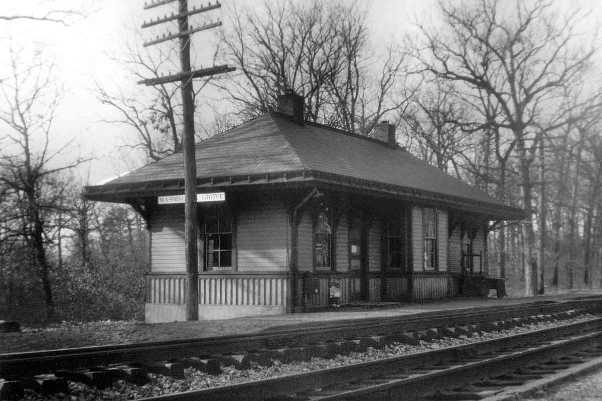
Photo credit William F Smith

Washington Grove Station
Mile: 20.7 Date: ~1940?
Ease: A View: W
Area: A IC2: 210
Map: Mo 19 J 10 Topographic Maps

In 1906 this Washington Grove Station replaced the original depot building. Note the postal mailbox, a fixture at railroad stations during the steam age. The station survived until 1958.


MARC Shack

MARC Shack
Mile: 20.7 Date: Jul 2012
Ease: A View: W
Area: A IC2: 210
Map: Mo 19 J 10 Topographic Maps

Near the site of B&O's depot and station, yet more diminutive than both, now stands this MARC commuter waiting shack. The fate of the humpback bridge in the distance may change this structure yet again.

Washington Grove was established in 1873 as a Methodist religious retreat camp. In 1951 a dog caused a work train to derail here, and the resulting legal case eventually found its way to the Supreme Court.

Link: Wikipedia


Humpback Bridge
Photo courtesy Dave Hiteshew

Humpback Bridge
Mile: 20.8 Date: Aug 2008
Ease: A- View: NW
Area: A IC2:
Map: Mo 19 H 10 Topographic Maps

Even with a hump, this bridge is about 2 feet too low for the double-stack trains scheduled to soon ply the Met. The bridge is newer than its timber supports imply, having been rebuilt in 1988 to copy the original 1947 form. The locals have grown fond of the quirky bridge and do not want CSX to remove it.

Link: history


Deer Park Drive

Deer Park Drive
Mile: 20.8 Date: Jul 2012
Ease: A View: NE
Area: A IC2:
Map: Mo 19 H 10 Topographic Maps

Though the humpback's roadway is wide enough for opposing traffic, the visibility is poor, so an uncommon system of traffic signals limits access to one travel direction at a time. Getting over the hump must be a challenge during winter ice and snow.

Link: in the snow 2011


From Humpback

From Humpback
Mile: 20.8 Date: Jan 2019
Ease: A View: SE
Area: A IC2:
Map: Mo 19 H 10 Topographic Maps

With some luck, while driving over the bridge you might see a train below.


MoPac 13577
Photo courtesy Dave Hiteshew

MoPac 13577
Mile: 20.8 Date: Aug 2008
Ease: A View: S
Area: B+ IC2:
Map: Mo 19 H 9 Topographic Maps

When Robert Herbert wanted the perfect office, he found Missouri Pacific caboose 13577 in Poplar Bluff, Missouri. After several months and several thousand dollars, the 1972-built unit arrived in Gaithersburg. The last new cabooses by a major manufacturer were built during the 1980s.

Links: Missouri Pacific info, news report


<< Previous (east) | THIS PAGE: Derwood to Washington Grove | Next (west) >>

Or, return to main page for other tours.

Copyright Notice