TrainWeb.org Facebook Page
B&O Metropolitan Branch Photo Tour


B&O Metropolitan Branch
Modern day photo tour

Accompanying each photo below are:

Click a photo to see a larger view. Please send your comments and corrections to Steve.


<< Previous (east) | THIS PAGE: Garrett Park to Woodmont | Next (west) >>

View Then
Photo credit Montgomery County Historical Society

View Then
Mile: 11.0 Date: 1901
Ease: A View: NW
Area: A IC2: 170
Map: Mo 36 D 4 Topographic Maps

Waiting passengers had this view when the station was but 10 years old; at that Crossing time B&O passenger service along the Met had reached its peak of 18 trains per day. This 4-4-0 engine is bound for DC. The building at right advertises Littlefield Real Estate, Rents, Loans.

The St. Paul Steet grade crossing (now closed) hosted a tower, semaphore signals, crossing gates, and a mail crane (left). During the century that followed, all of those would be gone, survived by the rails, utility poles and the building behind the tower.


View 2012

View 2012
Mile: 11.0 Date: Jul 2012
Ease: A View: NW
Area: A IC2:
Map: Mo 36 D 4 Topographic Maps

The survivor building right of center was the home of Mizell Lumber and Hardware from 1931 to 2011.

Link: Mizell Hardware shuttering


Mile 11
Photo courtesy Dave Hiteshew

Mile 11
Mile: 11.0 Date: Jun 2008
Ease: A View: NW
Area: A IC2: 170
Map: Mo 36 D 4 Topographic Maps

For about a half-mile west, the tracks run in what would appear to be a cut, but instead is earth mounded around the tracks to facilitate grade separation. Starting with the closest, the two bridges are Connecticut Avenue (bridge 11 C), and Summit Avenue. Beyond that, the grade slopes down to approach Rock Creek.


MARC 7751
Photo courtesy B&O History Collection

MARC 7751
Mile: 11.2 Date: Aug 1991
Ease: B View: NW
Area: A IC2:
Map: Mo 36 D 3 Topographic Maps

A MARC train rolls afternoon westbound commuters under Connecticut Avenue.


Summit Avenue
Photo courtesy B&O History Collection

Summit Avenue
Mile: 11.3 Date: 1988
Ease: B View: NW
Area: A IC2:
Map: Mo 36 D 3 Topographic Maps

Wooden bridges of this design were popular circa 1920. Summit Avenue received a newer bridge around year 2000.


B&O 6603
Photo courtesy B&O History Collection

B&O 6603
Mile: 11.5 Date: Nov 1990
Ease: B View: NW
Area: A IC2:
Map: Mo 36 C 3 Topographic Maps

Height and defect detectors were installed here during the 1980s. The lamps illuminated at left were part of CSX's On-Track system. Another On-Track installation was found at Marriottsville.


Rock Creek
Photo courtesy Dave Hiteshew

Rock Creek
Mile: 11.8 Date: Jun 2008
Ease: A View: S
Area: A IC2:
Map: Mo 36 B 3 Topographic Maps

Creek, railroad, and road make for a complex arrangement where the tracks cross Rock Creek Park at Beach Drive. The water enters here then flows under Beach Drive as both pass under the railroad.


Winter

Winter
Mile: 11.8 Date: Jan 2001
Ease: A View: NE
Area: A IC2:
Map: Mo 36 B 3 Topographic Maps

Relatively kess greenery reveals B&O did some fill work here: the tracks traverse at an elevation roughly 50 feet above Beach Drive. Less obvious is during the 1890s B&O re-routed Rock Creek so it would meet the then-new bridge perpendicularly so as to retard erosion.

Road crews worked here, too, since originally this bridge spanned just Rock Creek. During the 1960s Beach Drive was also threaded through, which accounts for the shallowness of the arch.

Link: Maryland Historical Trust filing (PDF)


Substantial
Photo courtesy Dave Hiteshew

Substantial
Mile: 11.8 Date: Jun 2008
Ease: A View: E
Area: A IC2:
Map: Mo 36 B 3 Topographic Maps

Stand close and it's tough to capture this bridge in a single photo. This is the most substantial stone arch we've seen on the Met tour so far. The pock marks on the stones are an artifact of circa-1900 quarrying methods.


Abutment
Photo courtesy Dave Hiteshew

Abutment
Mile: 11.8 Date: Jun 2008
Ease: A View: ?
Area: A IC2:
Map: Mo 36 B 3 Topographic Maps

An adjacent abandoned abutment is notable for two platforms at separate levels... B&O bridge afficianados recognize this as the hallmark of the railroad's signature Bollman design. Except the stonework is crude by B&O standards.

A 450-foot multi-span Bollman bridge may have graced this location before the stone arch behemoth supplanted it in 1896. However researcher Louis Koutris reports evidence this had never been used by the railroad, and that instead it supported an ordinary road.

Newport Mill had operated in this vicinity.

Link: Rock Creek Historic Districts (PDF)


CSX 2233
Photo courtesy Dave Hiteshew

CSX 2233
Mile: 11.9 Date: Jun 2008
Ease: B View: S
Area: A IC2:
Map: Mo 36 B 2 Topographic Maps

Here wearing the gray paint of a Road Slug, CSX 2233 is a model GP30 built as B&O 6922 during 1962. It was still on duty as of 2021. On this day it was escorted by CSX 6461 and CSX 6248.

Links: B&O 6922, 2021


AMTK 210
Photo credit HL Buckley
B&O History Collection

AMTK 210
Mile: 12.4 Date: Aug 1972
Ease: A View: E
Area: A IC2:
Map: Mo 36 A 2 Topographic Maps

B&O 92 2000 The photog gets a wave from the Amtrak engineer as this ex-B&O model E8A proceeds into Garrett Park. As of 2000, this same unit, formerly B&O 92, was sitting in the B&O Museum's back lot (left) before being moved to West Virginia where at last check during 2017 it remained unrestored.

Links: 2014, 2017


Garrett Park
Photo courtesy Dave Hiteshew

Garrett Park
Mile: 12.4 Date: Jun 2008
Ease: A View: NE
Area: A IC2:
Map: Mo 36 A 2 Topographic Maps

Once upon a time, this location hosted both a B&O station and typical automobile grade crossing, but post-WWII decline in passenger demand led to their closure. Nearby residents enjoyed the solitude. Later in the 20th century fuel costs rose and more people wanted to again commute by train. This demand see-saw tug-of-war is nowhere better exhibited than at Garrett Park where competing desires produce the curious, confusing amalgam that sometimes evolves from compromise.

Perhaps fittingly, the adjacent park is named not Garrett but rather the hyphenated Waverly-Schuykill. The name Garrett originates with a B&O President, but the locals disagree whether it was John Garrett or Robert Garrett.


Garrett Park Station
Photo courtesy B&O History Collection

Garrett Park Station
Mile: 12.4 Date: Mar 1958
Ease: A View: S
Area: A IC2:
Map: Mo 36 A 1 Topographic Maps

Many people assume the B&O station was the Black Market Bistro restaurant (as of 2021), but there was an actual B&O station where the MARC parking lot now is. The ex-grade crossing in the prior photo formerly provided access to a fuel oil dealer behind the station.

Link: 1975


Shack
Photo courtesy Dave Hiteshew

Shack
Mile: 12.4 Date: Jun 2008
Ease: A View: W
Area: A IC2:
Map: Mo 36 A 1 Topographic Maps

MARC commuters can await trains about 150 feet west of the quasi-grade crossing in this shack that originally belonged to the Pennsylvania Railroad (at Landover, Maryland).

Links: at Landover 1978, 1972, 1976, Historical Marker Database entry


MARC 22
Photo courtesy B&O History Collection

MARC 22
Mile: 12.4 Date: Sep 1990
Ease: A- View: NW
Area: A IC2:
Map: Mo 36 A 2 Topographic Maps

An ex-B&O, MARC Budd RDC unit heads west out of Garrett Park. Yes, there is also a MARC 22 engine. As of 2016, this unit was part of the Tennessee Valley Railroad Museum collection.

Links: 1968 as B&O 1910, 1987, 1996, 2016


Tiny
Photos courtesy Dave Hiteshew

Tiny
Mile: 12.5 Date: Jun 2008
Ease: B View: N
Area: A IC2:
Map: Mo 36 A 1 Topographic Maps

culvert interior Culverts don't get much smaller than this one just a few feet across.

Like many/most Met culverts, a masonry shelf extends the full length.


Railfox
Photo courtesy Dave Hiteshew

Railfox
Mile: 12.6 Date: Jun 2008
Ease: B View: NW
Area: A IC2:
Map: Mo 36 A 1 Topographic Maps

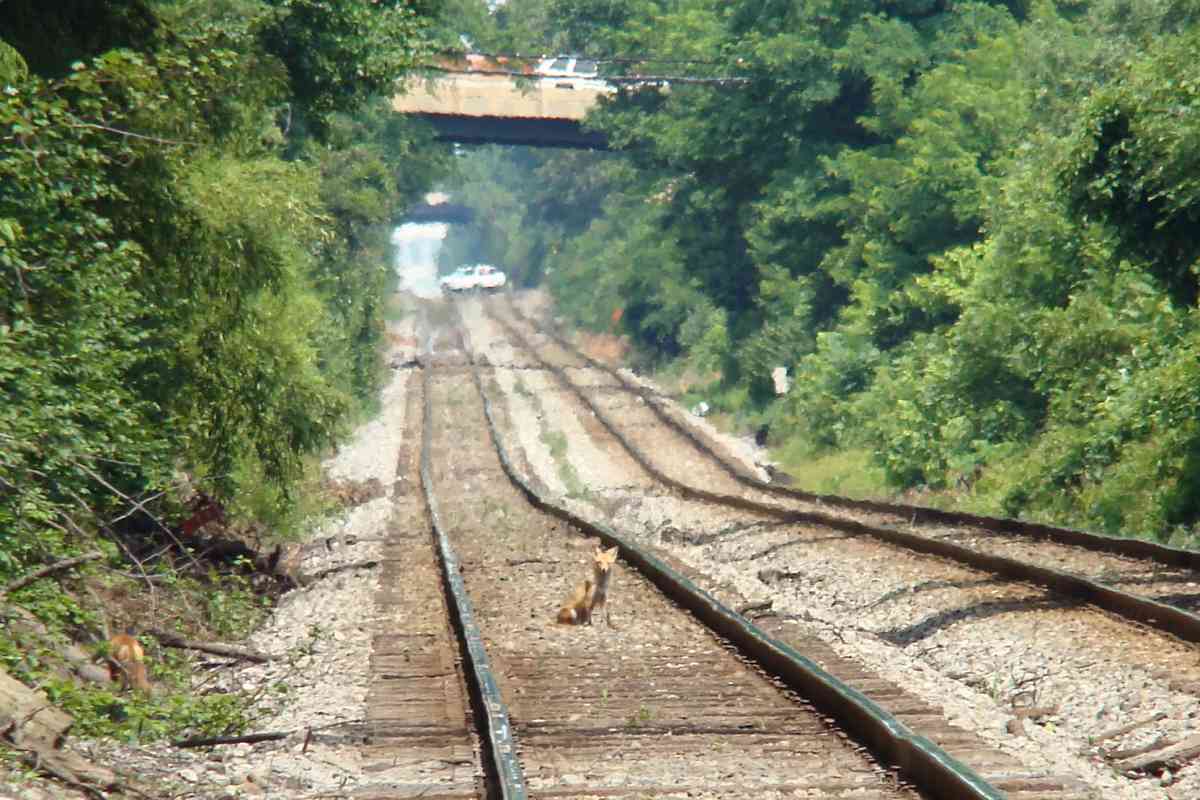
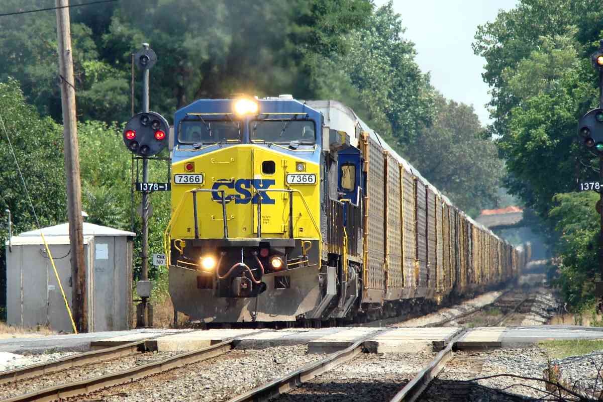
Two wild and crazy foxes are Czeching out the rails. There's plenty of time to relax since a white SUV blocks the tracks beyond. Actually, no, that's the Randolph Road grade crossing seen through about a mile of max-zoom heat-distorted June air.

When trackside you need to be ready for critters of all kinds. Even black bears are known to venture this far east, particularly during May and June when younger males are establishing new territory.

You won't find this magnitude of grade change along the Old Main Line. By the time the Met was engineered (40 years after the OML), B&O had learned to worry about keeping the track straight first, level second.

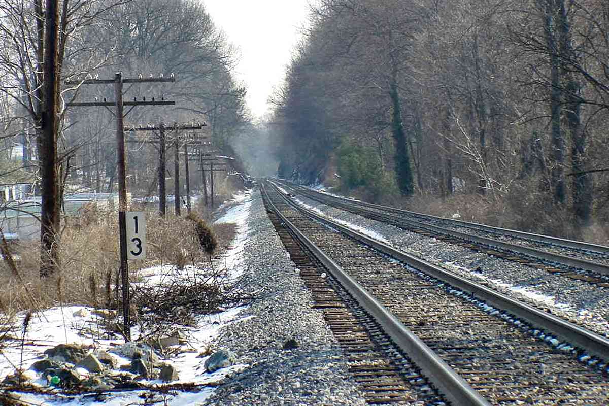
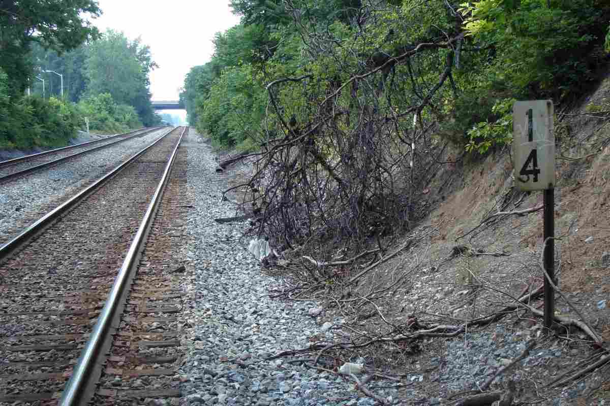
The white rectangle on the right is milepost 13, beyond that is a bridge for Nicholson Lane / Parklawn Drive, and a bit further is a forgotten B&O stop named Windham. Since I have not found any pictures of a Windham Station, I assume little more than a passenger waiting shack had existed.


Poles

Poles
Mile: 13.0 Date: Jan 2001
Ease: A- View: SE
Area: A IC2:
Map: Mo 35 K 1 Topographic Maps

Looking back both directionally and temporally reminds that when CSX removed the utility poles, the right-of-way lost some traditional railroad flavor.


Windham

Windham
Mile: 13.2 Date: Apr 1999
Ease: A View: NW
Area: A IC2:
Map: Mo 29 K 13 Topographic Maps

Turning to look the other way, this is a 20th century springtime view from the Nicholson Lane bridge. Long ago Windham Station had been in this area. The trackside W signs are reminders to blow the whistle for the Randolph Road grade crossing, where you see the blue car.


Randolph Station
Photo credit B&O Museum

Randolph Station
Mile: 13.7 Date: ~1920
Ease: A View: SE?
Area: A IC2:
Map: Mo 29 J 12 Topographic Maps

Randolph was never a major stop so this small station sufficed; it is no longer extant, however aerial photos suggest it was still present as of 1951. I believe the Randolph Road grade crossing was immediately behind the photographer.

Link: Randolph Station


Randolph Road
Photo courtesy Dave Hiteshew

Randolph Road
Mile: 13.7 Date: Jun 2008
Ease: A- View: NW
Area: A IC2:
Map: Mo 29 J 12 Topographic Maps

CPLs at Randolph Road sleep, saving their lamps for impending retirement.

Since the time of the prior photo, Randolph Road grew into the Met's busiest at-grade crossing. Grade separation has been on the drawing board for years.


CSX 7366
Photo courtesy Dave Hiteshew

CSX 7366
Mile: 13.8 Date: Jun 2008
Ease: A- View: SE
Area: A IC2:
Map: Mo 29 J 12 Topographic Maps

Both CPLs awaken when CSX 7366 enters the block with empty racks westbound to pick up more autos.


Milepost 14
Photo courtesy Dave Hiteshew

Milepost 14
Mile: 14.0 Date: Aug 2008
Ease: B View: NW
Area: A IC2:
Map: Mo 29 H 12 Topographic Maps

Twinbrook Parkway is the next overpass, but before that, shrouded on the left, an old acquaintance, the DC Metro Red Line, will rise from the subterranean to rock and roll alongside as seen below. Old maps and photos show a small, perhaps private bridge over the railroad near here.


MARC 24
NEW! mid-Aug 2023

MARC 24
Mile: 14.4 Date: Aug 2023
Ease: A View: SE
Area: A IC2:
Map: Mo 29 H 11 Topographic Maps

Westbound MARC 24 arrives just as an east/southbound Metro Red Line train goes underground. The distant red rectangle is the side of a truck at the Randolph Road grade crossing.


Halpine
NEW! mid-Aug 2023

Halpine
Mile: 14.6 Date: Aug 2023
Ease: A View: SE
Area: A IC2:
Map: Mo 29 G 10 Topographic Maps

Around 1964 when the Twinbrook Parkway overpass (distance) was built, Halpine Road's grade crossing (bottom-left quarter) and B&O station were shuttered. Halpine Station 1951 No surviving trace of Halpine Station is to be found because Metro's Twinbrook Station has taken up residence. To add insult to injury, CSX labels its utilty boxes here Montrose. Note CSX's use of concrete crossties for the track crossovers.

One of the structures adjacent the Halpine Road grade crossing at the center of the low-resolution 1951 aerial at right could well be B&O's station. Most of its Met stations were along the south/west side of the tracks. The bright horizontal line visually above the grade crossing is not a bridge but rather merely a staple in the photographs.


B&O 1434
Photo courtesy B&O History Collection

B&O 1434
Mile: 15.0 Date: Mar 1966
Ease: B View: SE
Area: A IC2:
Map: Mo 29 F 9 Topographic Maps

B&O 1434 was built by the Electro-Motive Division of General Motors during 1938, then rebuilt 15 years later into the model E8Am form seen here. The bright track ballast looks fresh.

Link: in Kensington 1964


Milepost 15
Photo courtesy Dave Hiteshew

Milepost 15
Mile: 15.0 Date: Oct 2008
Ease: A View: NW
Area: A IC2:
Map: Mo 29 F 9 Topographic Maps

The over-four-mile straightaway between Garrett Park and Rockville is the Met's longest.


Twinbrook Metro
Photo courtesy Dave Hiteshew

Twinbrook Metro
Mile: 15.7 Date: Aug 2008
Ease: A View: SE
Area: A IC2:
Map: Mo 29 E 8 Topographic Maps

Now Metro is on the right because we're looking back from the Edmonston Drive bridge to a pair of headlights departing Twinbrook Metro station, over a mile distant. An 1889 list puts Outree Park Station here.


From Edmonston 1947
Photo credit EL Thompson

From Edmonston 1947
Mile: 15.7 Date: 1947
Ease: A View: NW
Area: A IC2:
Map: Mo 29 E 8 Topographic Maps

The Edmonston Drive bridge was new in 1947 when EL Thompson spotted B&O 74 EMD model E7A bound for Washington.

Click the thumbnail to peer into the distance and you'll find a bridge with a pyramidal support structure.


From Edmonston 2008
Photo courtesy Dave Hiteshew

From Edmonston 2008
Mile: 15.7 Date: Aug 2008
Ease: A View: NW
Area: A IC2:
Map: Mo 29 E 8 Topographic Maps

Sixty years of highway expansion in the DC-to-Frederick corridor boosted Rockville's skyline changes, and brought Metro that subdivided the B&O right-of-way into halves.

At photo time the pyramidal structure in Rockville was still extant, peeking above the bridge for Veirs Mill Road in the foreground.


Amtrak 329
NEW! mid-Aug 2023

Amtrak 329
Mile: 15.7 Date: Aug 2023
Ease: A View: NW
Area: A IC2:
Map: Mo 29 E 8 Topographic Maps

This is the first published photo of Amtrak 329, a Siemens model ALC-42 wearing Phase VII livery while on its way to Washington.


<< Previous (east) | THIS PAGE: Garrett Park to Woodmont | Next (west) >>

Or, return to main page for other tours.

Copyright Notice