Adventurers in Utah for Spike
150
Promontory Summit -
150 years later
A Sesquicentennial
Chapter One
Afton Canyon Train
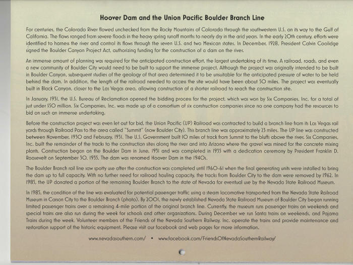
Nevada Southern Railway Museum, Bolder
City
Drive the Northshore Road, Lake Mead National
Recreation Area
and Valley of Fire State Park
May 2, 2019
Thursday
by
Robin Bowers
Text and Photos by Author
The
author retains all rights. No reproductions are allowed
without the author's consent
Comments are appreciated at...yr.mmxx@gmail.com
The
month of May is ordinarily not chosen as a month for the
National Railway Historical Society to hold its annual
convention. But one day in May holds a special place in the
hearts and minds of train enthusiasts and history buffs. It was
the day our nation had the first transcontinental railroad
completed. A person could now travel from sea to shining sea in
several days instead of several months as in the past.
On May 10, 1869, two
locomotives - Central Pacific's Jupiter and Union
Pacific No. 119 - pulled up to the one-rail gap left in
the track. After a golden spike was symbolically tapped, a final
iron spike was driven to connect the railroads. Central Pacific
had laid 690 miles of track, Union Pacific 1,086. They had
crossed 1,776 miles of desert, river and mountains to bind
together East and West.
So it was decided that the
2019 NRHS annual convention was to be held in "The Beehive
State" so to participate and witness the festivities of a
150 anniversary celebration.
Both Chris G. and I were
excited about making a trip for the 150 celebration and going to
Salt Lake City. Chris would take a one week vacation plus two
more days off work and be able to make the trip. Our first day
would start on Thursday, Friday and then the next week,
returning on Sunday night so he could be back at work on Monday.
This morning would find me
packing the last bag, making sure the apartment was secure, and
the refrigerator made ready for a ten day absent. I drove over
to Chris's house but was delayed by big accident in the HOV lane
on the northbound 55 freeway. After arriving I parked in his
driveway and packed my bags in his car to start our journey. We
made our way east to I-15 and headed north to Las Vegas and then
on to Salt Lake City. I-15 is very busy northbound on Friday
nights to Las Vegas and then southbound Sunday afternoon. By
leaving on Thursday we hoped to avoid the northbound traffic but
coming home on Sunday night be busy but unavoidable.
We had left Barstow, CA and were about half
way to Baker, when Chris spotted a eastbound train near Manix so
we got off at Afton Road exit. Thirty five miles east of Barstow
is the Afton exit south. After driving south three miles on a
graded dirt road, we passed the Afton Campground. From there it
was about another three miles to Chris' unsuspected photo spot.
We climbed a slight hill and waited.

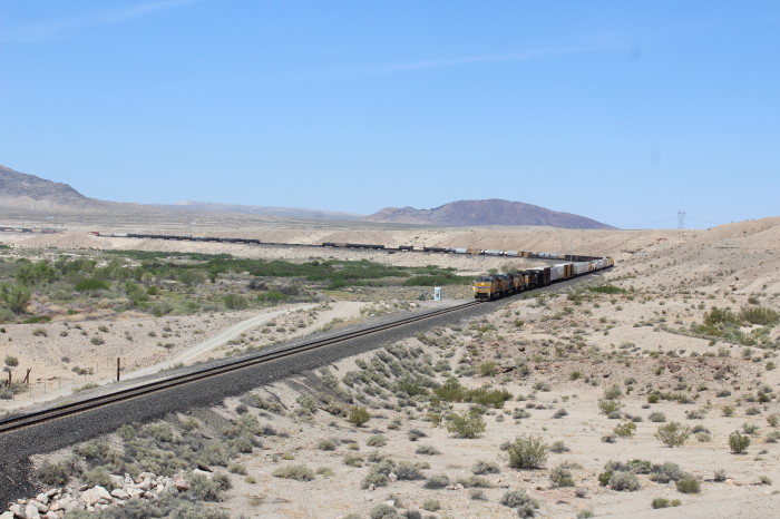

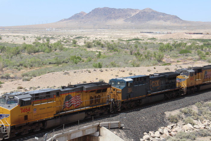
Union Pacific 7464 East passes by our location at the west end of
Afton Canyon.

Afton Canyon's surface water
makes it unique in the southern California desert. Known locally
as "The Grand Canyon of the Mojave" for its dramatic geological
formations, this is the only place where the Mojave River flows
above ground year-round - providing significant riparian
(riverbank) wildlife habitat amid the desert. Since prehistoric
times, the natural bounty created by this water source has made
Afton Canyon a focus for living things. Dense willows and
cottonwoods shaded the river, and thickets of mesquite produced
bean pods for food. The ponds, marshes and streams provided
habitat for a wide variety of wildlife species.


From here we drove back to I-15 and continued north pass Baker and
onto our first stop on this trip at Boulder City.

Located along I-15 near the California and Nevada state-line.

The Ivan Solar Farm in Prim, New.
Boulder City
"The town that built Hoover
Dam" sprang from the Mojave Desert in 1931 when a site was
needed to house the thousands of Depression-era workers
constructing the concrete behemoth on the nearby Colorado River.
Aiming to keep the crews and project on schedule, gambling and
alcohol were outlawed within the city limits. This is still one
of only two Nevada cities that prohibit gambling.
Hoover Dam is along SR 172
about 8 miles northeast of Bolder City. Soaring 726 feet high
(about 60 stories), this curved wall of concrete is one of the
highest dams ever constructed. It's also a hugely popular day
trip from Vegas, and with good reason. The Depression-era
engineering marvel (built 1931-35) sits in Black Canyon, a
ruggedly dramatic Colorado River chasm that's home to the dam,
its mega-wattage hydroelectric power plant and a visitor
center/tourist complex with all the bells and whistles.
After my mother graduated from
nurse's training (1935), one of her first positions was as a
private duty nurse to a rancher returning home to Montana from
Ohio. One of their stops was in San Diego where she fell in love
with California. Another stop was at Hoover Dam, under
construction, that she said it was amazing to see with all the
workers and the huge size. Two of the most memorable occurrences
of her trip, she related.
,


Union Pacific GP-30 844.
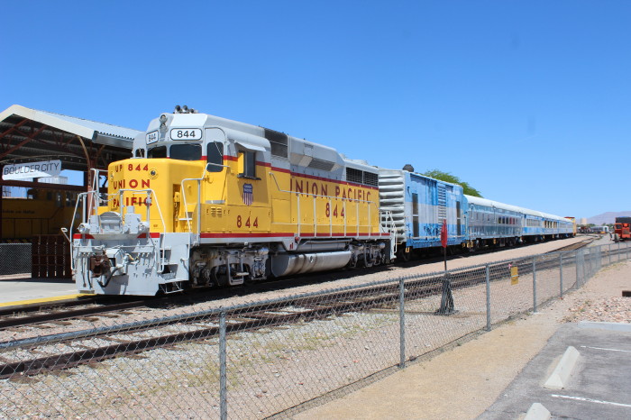
Train consist ready for next trip of excited passengers.

Pacific Lumber 2-8-2 35.


Jackass & Western L-2, GE-25 Ton.

Union Pacific 2-8-0 264.

Union Pacific United States Railway Post Office car.


Union Pacific caboose WP 449.


DYRX F-40PH 231.

NSRM H12-44 1855.


Passenger cars.


As I was finishing up taking
my photos, the site manager approach on his electric cart. I
thanked him for the great display he had here at the museum.
Told him we were on our way to SLC and the Spike 150 activities.
He said some of the locals were disappointed that their
railroads were not asked to participate. Guess they weren't on
UP's "A list." I notice that they had calendars on sale and
asked the manager that I would like to get one if it was
convenient as everything was closed and locked up. No problem he
said, and walked over to the ticket office, open the door and
there close by and handy was my calendar. After I made my
donation to the cause, I had my new calendar. Then Chris walked
up said he was finished and asked if I was ready to leave. Yes,
I was satisfied with my shots and ready to go. We drove over to
a near-by A&W stand. It was 2:30pm and hungry so I had a
hamburger, fries and for sure - a root beer float. Good, Good.
As we travel across country, we try to stop at an A&W when
we see them.
I have visited Boulder City twice before - in
the late 60s. Once alone and the other with a brother and we
were camping at the rim of the Grand Canyon. I remembered going
to a drug/souvenir shop where in the back of the store there was
a small theater and we watched old new reels and historic photos
on building the dam. Also remembered the lone empty main street,
a sleepy little town several miles from the highway. I was
disappointed that could not spend more time here and see how
many or if any memory's from 50 years ago could be reconnected.
We also put fuel in the
car and then we were off on our journey. From here we headed to
the Lake Mead National Recreation Area.
Lake Mead National Recreation Area
Lake Mead, extending behind
Hoover Dam, is 110 miles long, averages 200 feet deep at
normal capacity and has a 550- mile shoreline. Due due to
recent drought conditions, the lake's surface elevation is
1080 feet (1,229 feet is considered a full pool).
As I forgot to bring my
America The Beautiful Senior Pass, we had to pay the
entrance fee and then began our drive on Northshore Road.
This road would take us to the entrance station to Valley of
Fire State Park. Along the way we passed several picnic
areas and overlooks around the lake.

Lake Mead.


Northshore Road.


The north end of Lake Mead. From here we drove into Valley of Fire
State Park.
Valley of Fire State Park
Valley of Fire State Park is a
public recreation and nature preservation area covering nearly
46,000 acres located 16 miles south of Overton, Nevada. The
state park derives its name from red sandstone formations, the
Aztec Sandstone, which formed from shifting sand dunes 150
million years ago. These features, which are the centerpiece of
the park's attractions, often appear to be on fire when
reflecting the sun's rays. It is Nevada's oldest state park, as
commemorated with Nevada Historical Marker #150. It was
designated as a National Natural Landmark in 1968.
Valley of Fire is located 50
miles northeast of Las Vegas, at an elevation between
1,320-3,009 feet. It abuts the Lake Mead National Recreation
Area on the east at the Virgin River confluence. It lies in a 4
by 6 mi basin.
Geology
Complex uplifting and faulting
of the region, followed by extensive erosion, have created the
present landscape. The rough floor and jagged walls of the park
contain brilliant formations of eroded sandstone and sand dunes
more than 150 million years old. Other important rock formations
include limestones, shales, and conglomerates.
History
Prehistoric users of the Valley
of Fire included the Ancient Pueblo Peoples, also known as the
Anasazi, who were farmers from the nearby fertile Moapa Valley.
Their approximate span of occupation has been dated from 300 BC
to 1150 AD. Their visits probably involved hunting, food
gathering, and religious ceremonies, although scarcity of water
would have limited their stay. Fine examples of rock art
(petroglyphs) left by these ancient peoples can be found at
several sites within the park.
The creation of Valley of Fire
State Park began with transfer of 8,760 acres of federal land to
the state at Nevada in 1931. Work on the park was initiated by
the Civilian Conservation Corps in 1933. During the years of
their employment, which continued into the early 1940s, the CCC
workers built campgrounds, trails, stone visitor cabins,
ramadas, and roads. The park opened in 1934; it achieved
official designation by the state legislature in 1935.
Climate
The Valley of Fire State Park
has a dry and warm climate typical of the Mojave Desert in which
it lies. Winters are mild with daytime temperatures ranging from
54 F degrees to 75 F degrees and over night lows in the mid 30 F
degrees to mid 40 F degrees Storms moving east from the Pacific
Ocean occasionally bring rain during winter months. Daily summer
highs usually range from 100 F degrees to 115 F degrees and on
occasion may reach near 120 F degrees. Thunderstorms from the
Southwestern Monsoon can produce heavy showers during summer.
The average annual precipitation is 6.50".
Valley of Fire Road
Valley of Fire Road is the main
road accessing and traversing through the park. The 10.5-mile
section of the road between the east and west entrances of the
park was officially designated as a Nevada Scenic Byway on June
30, 1995.
Activities and amenities
The park has a visitors center
plus facilities for picnicking, camping, and hiking. Petroglyphs
are seen throughout the park, with Mouse's Tank and Atlatl Rock
two areas in particular with numerous petroglyphs that are
relatively easily accessible. The park also preserves three
stone cabins built by the Civilian Conservation Corps.
Our Visit
We drove by the east gate then
stopped to take some pictures.


Seven Sisters.


We went to the Visitor Center as they were closing and paid the
state park entrance fee. We then drove the White Domes Road with
stops along the way.


End of White Domes Road Scenic Route. Sandstone formations with
brilliant contrasting colors, picnic area, and a 1.25-mile scenic
trail with a slot canyon. White Domes is a 5.5-mile (20-minute)
drive from the Visitor Center. After we parked, I started down the
scenic trail but only proceeded some several hundred feet due the
trail being thick sand. It was very tiresome to walk far. Beach
sand and desert sand seemed no different.


After cutting my hike short, I returned to the parking lot and met
up with Chris and then we drove back through the park to the east
entrance with a several stops along the way.


After exiting the park, we went north on Highway 169 through
Overton, where the Union Pacific still has an active branch line.
and then on to I-15 northbound.


Highway 169.

Arizona rocks.

After going through a slip of Arizona, shortly we were in Utah and
on our way to tonight's stop in Cedar City.

Snow on Utah mountains.
After arriving in Cedar City, we stopped to refuel the car, then a
stop at Subway for a sandwich to eat later in the motel room for
after checking into Knights Inn.
California, Nevada, Arizona and Utah all on our first day. A good
and busy day.
Thanks
for reading.
Next Chapter - Tooele, Salt Palace and Bingham
Canyon Copper Pit.
Text and Photos by Author
The
author retains all rights. No reproductions are allowed
without the author's consent.


