


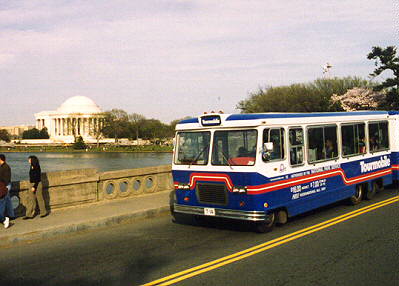
Our highway tour begins, appropriately enough, with a Tourmobile. Dozens of these craft ply the streets of Washington in search of tourists whose heavy wallets have made them tired of walking. That's the Jefferson Memorial in the background. This photo was taken April 13, 1999, the day the Tidal Basin's cherry tree blossoms peaked.
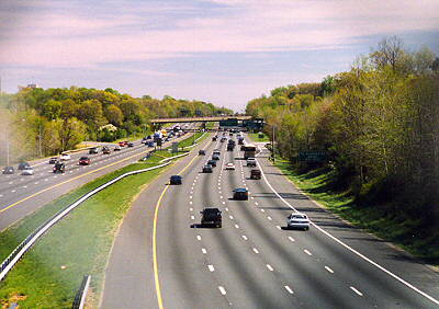
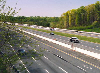
This is the Capital Beltway that encircles Washington; this image was captured on April 24, 1999, a Saturday, looking southeast from the Cherrywood Lane overpass. On weekdays, the vehicle density is much greater.
For highways, I prefer photos from above wherever possible because I think they provide a better perspective. Armed with detailed street maps, I was navigator and my wife, Michelle, (who loves to drive) the pilot. We criss-crossed the city looking for quiet overpasses with good highway views. We quickly learned that fences on the overpasses would prove very troublesome. Ostensibly, the fences are present to prevent people from throwing things (including themselves) onto the vehicles below. Of course, they fail miserably because a determined maniac can still easily toss objects over or through the fence. However, the fences do excel at impeding good photography, witness the image at left shot through the chain links.
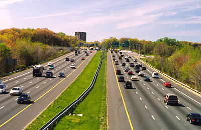
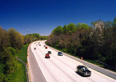
Fortunately, in some places the fences are short enough that you can stand on the concrete guardrail below and take unobscured photos from above. This is the Capital Beltway (I-495) in Maryland near where it intersects with US Rt. 1 and I-95.
Washington suffers from very poor highway connections. From Maryland, there are no limited access highways that go to the downtown area. Instead, major routes such as I-95, end at and dump traffic onto the Beltway. Originally, I-95 was to pass through the city, but construction was halted by NIMBYs. NIMBYs also caused the Beltway's route, particularly in Maryland, to veer and swerve. Overturned trucks are not uncommon. As a consquence, millions of hours per year are wasted by commuters sitting in Beltway traffic. Hmmm, come to think of it, some of these commuters are politicians. While stuck in traffic, they can't make more new laws. Perhaps this congestion is a good thing after all... Here's a live camera image.
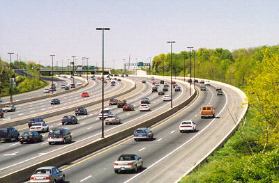
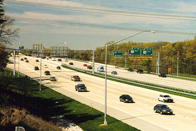
When are 12 lanes not enough? When it's I-270. I-270 extends from Frederick, MD, where it intersects I-70 down to its other end point, you guessed it, the Capital Beltway. This is the only major NW-SE route in the vicinity and is very heavily travelled. This photo was taken May 2, 1999, a Sunday, from the Wootton Parkway overpass.
Also 12 lanes, but not quite as busy, is the Dulles Airport Access Road. This is also known as the Hirst Brault Expressway, but if you call it that, the locals will look at you quizzically. This is the view northwest from the Trap Road overpass. Notice how, unlike I-270, the four-lane segments are on the outside. This is because the inner lanes serve the airport exclusively. Also, while there is a toll for using the outer lanes, the inner lanes are free. (More politicians at work.)
This unusual toll arrangement has encouraged local commuters who live near the airport to use the inner lanes to bypass the tolls, then circle around and exit the airport. Supposedly, the police now monitor the airport traffic to discourage this toll-skipping technique. This silliness could only happen in Washington.
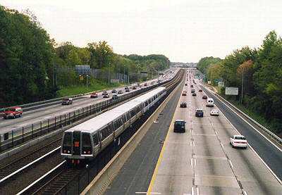
It's a Metro route. No, it's an interstate highway. Wait, you're both right! This is I-66 looking east from the Cedar Lane overpass in Vienna, VA. Metro's Orange line shares the route for several miles. The Capital Beltway is just past the incline in the distance.
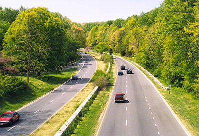
Perhaps the most bucolic of all highways near Washington is the George Washington Parkway. It extends from Mount Vernon, Virginia (GW's home) to, yup, the Capital Beltway. The road parallels the Potomac River, and it's a pretty drive in the evening as you can easily see the nicely lit monuments (Lincoln, Jefferson, etc.) across the river.
This photo is looking northwest from the CIA's very own personal cloverleaf. We parked the car bomb, er, minivan (that's just a joke, guys!) at the CIA's gates, then walked out onto the overpass to snap this shot. Upon walking back, we saw the sign "NO PHOTOGRAPHY! CAMERAS WILL BE CONFISCATED!" at the gate. Fortunately, no one questioned us, so we did not need to convince anyone that we only took photos of the road. Honest!
Fooled you! This is not the GW Parkway again, it's the look-alike BW Parkway, the Baltimore-Washington Parkway, also known as Rt. 295. This is the view looking north from the Rt. 198 overpass in Laurel, Maryland. The overpass in the distance is that of Rt. 32.
If you are leaving Baltimore, and want to get onto Rt. 295, follow Russell Street southward. There are absolutely no signs telling you that the street eventually becomes 295. Alternatively, you could rent a copy of Sleepless in Seattle. Russell Street to 295 is the route driven by Meg Ryan's character near the start of the movie.
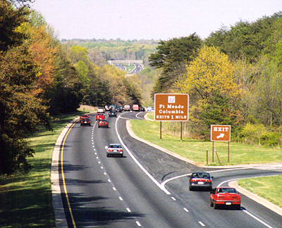
Even the "non-parkways" in central Maryland are scenic. These are the southbound lanes of I-95 as seen from the Vollmerhausen Road overpass. Twelve lanes are unnecessary because there are many different roads that parallel I-95 between Baltimore and Washington.
This is one of the few portions of I-95 that still uses the original concrete surface laid down around 1970. The construction cones hint that an asphalt overcoat will soon be applied to this section. This photo was taken April 25, 1999.
This is the highest numbered interstate highway in the US: I-97 (not counting the way-out-of-place, politically assigned I-99). It's not really an interstate highway since it is contained entirely within Maryland. Are there any other two-digit (i.e. non-spur) interstate imposters in the lower 48?
The concrete surface should last well into the 21st century. This is the view looking northeast from the Stewart Avenue overpass near BWI Airport.
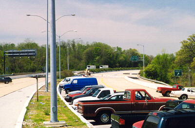
We've all heard the joke about the highway that was so overloaded with traffic that it became the world's longest parking lot. Well, here is a bizarre photo of a highway that really is a parking lot.
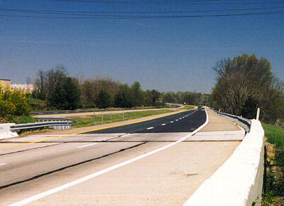
I-70's western endpoint is in Utah, and the eastern endpoint is here in Baltimore. Behind me when I took this photo was the equally strange view of 8 nicely paved lanes abruptly terminating at the brush and weeds of Leakin Park. I-70 was supposed to connect through to I-95, but the project was halted by environmentalists concerned about the park. The result is the last mile of I-70 is nearly deserted, and not long ago, was converted into a Park and Ride lot.
This is the photo for which I risked life and limb. As you can tell from the dearth of cars, I-895 is the best kept highway secret in Baltimore. This road connects to the older and now underutilized Baltimore Harbor Tunnel. There is also a dearth of overpasses from which to get an overhead photo. So, instead I chose to visit at the quiet underpass of the unpaved Halethorpe Farms Road, which ends a few feet east of I-895 in the Patapsco Valley State Park.
The problem was the fence which discourages people from wandering from the park onto the highway. It ran as far as the eye could see, and was an 8 foot tall chain link variety with spiked tops. That wasn't insurmountable. The weeds and poison ivy covering it were. However, nearby was a gate in the fence, locked, but obviously used in the recent past because it was not overgrown with vines. Additionally, the top lacked the spikes. So, I scaled it, walked up the embankment to the road, and took a couple of photos. Simple, right?
Upon returning, I noticed a swarm of huge wasps was now angrily buzzing about the gate. Apparently, they had a nest in the gate post, and my entry had upset them. This was one difficultly I had not anticipated. So, the options were poison ivy, wasps or walk an unknown distance through heavy brush to find a gap in the fence. I chose to sit and wait. Eventually, the wasps calmed a bit, and when there was a lull in the swarm, I dashed over the fence and escaped unharmed.
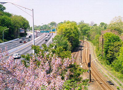
This is I-83, also known as the Jones Falls Expressway and JFX, in Baltimore looking north from the quiet Wyman Park Drive overpass a short distance west of Johns Hopkins University. Baltimore's light rail system, seen here on the right, parallels I-83 for several miles. This location is a few blocks north of the Baltimore Streetcar Museum, which I've yet to visit, but heard is a great location for watching trains.
Return to main photo project page
Comments? Corrections? EMail intersys@insystem.com
All text and images on this page are Copyright 1999 by Intersystem Concepts, Inc. Permission is granted to copy and reuse the text and images from this page provided 1) no fee is charged, 2) our original copyright is preserved, and 3) we are credited as the source (please include a link back to this page).


