


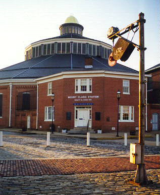
One of my first stops on a crisp day in February 1999 was the B&O Railroad Museum in Baltimore. For railfans, this is definitely worth visiting. The collection of trains and memorabilia is very impressive. Inside the roundhouse, photography for anything but personal use is not allowed, and the somewhat dim lighting makes things difficult. I recommend a fast film (ASA 400 minimum). I was using 200 with on-camera flash, and that resulted in dark photos. It's just as well I can't show you the results.
The equipment outdoors is fair game for photogs, and that's where I snapped the locomotive below. Everywhere the equipment is tightly packed, making it quite a challenge to get interesting photos of individual pieces. The front of the locomotive shown below is just inches from the back of another car.
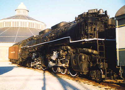
Days in February are still short, and shadows were creeping up when I took this shot of Chesapeake and Ohio locomotive 1604. This 2-6-6-6 Allegheny weighs in at 778,000 pounds, making it the heaviest reciprocating steam locomotive ever built.
After this, I put the camera away to wait for spring's longer days and greener vistas.
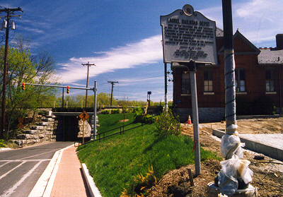
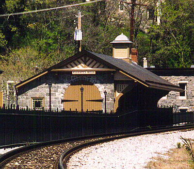
On a nice day in April, I headed for the depot on Main Street in Laurel, Maryland. This was a stop along the B&O's mainline route between Baltimore and Washington. It is still in use, now as a MARC commuter rail stop; in the photo you can see the edge of the new Park and Ride lot being constructed. The text on the marker reads: "LAUREL RAILROAD DEPOT - Built by the Baltimore and Ohio Railroad in 1834, this 'American Queen Anne' structure continues in daily use. The architect Francis R. Baldwin also designed the rear wing of the State House in Annapolis. This building was placed on the National Register of Historic Places in 1972." The traffic signal controls the single lane road that passes under the 160+ year old right of way.
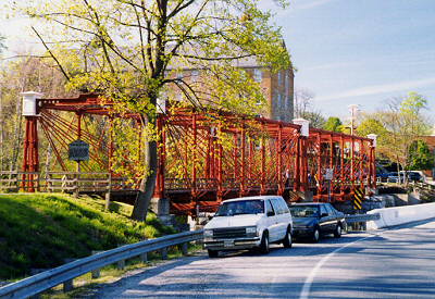
Not far from Laurel is Savage, Maryland, site of the Savage Mill, and the attractive Bollman Bridge (directions). The marker reads "Bollman Iron Truss Bridge - 1869 - Spanning the Little Patuxent River is the sole surviving example of the bridging system invented 1850 by Wendel Bollman, Baltimore Engineer. It was the first system entirely of iron used by the Baltimore and Ohio Railroad and the first in America. Through 1873 the company built about 100 such bridges."
Iron bridges were much cheaper than stone, and much sturdier than wood. Those diagonal pieces you can see are flat, solid pieces of iron, not cables. Technology improvements later in the 19th century allowed bigger bridges (such as NY's Brooklyn Bridge) to be built more easily with the help of steel cables.
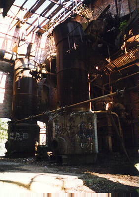
In the 1800s, the Savage Mill was a major cloth making facility, and the B&O built a mainline spur to serve it, hence the bridge you see above. Originally, the mill was powered by running water, but in 1880, it converted to steam. The photo to the right shows the ruins of the steam boilers which were housed in a multi-story brick building along the edge of the river. Apparently sometime later the mill converted to electricity as there are also ruins of large generators nearby. Currently the mill structures are in use as an antique marketplace and offices for artists. The current plans to construct a restaurant straddling the river will likely result in the removal of the steam and electric ruins.
If you rode the very first train out of Baltimore on May 24, 1830, upon arriving at the next station, this is what you would have seen from the front. This is Ellicott's Mills (now Ellicott City), the site of the first railroad station in the USA. The structure now houses a small museum. The mill which was the impetus for building the RR through this location remains in operation. The grain storage elevators tower over the station (though cannot be seen in this picture). Some of the wooden RR ties in this area are original as evidenced by their roughly hewn, non-square shape.
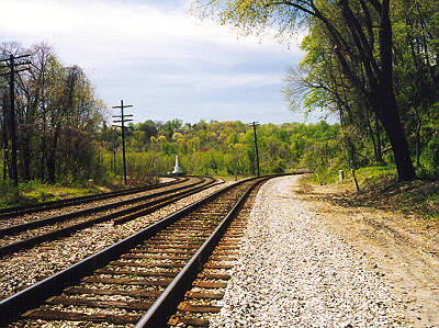
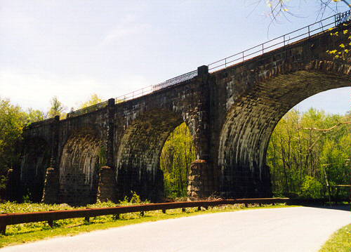
If you were to follow the old-main line tracks out of Ellicott City toward Baltimore you would arrive at Relay, Maryland, site of the Thomas Viaduct. This photo looks southwest back toward where the tracks split to Ellicott City on the right, and Washington, DC on the left. This is the route traveled by the world's first telegraph message "What hath God wrought!" sent by Samuel Morse on May 24, 1844. If you want to visit this location, get a good street map of the area and find your way to Railroad Avenue (directions). You can park your car near where this photo was shot, which is only a few hundred feet from the viaduct itself. The white object in the distance is the obelisk shown below left.
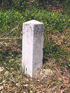
As you walk toward the viaduct, note the mile marker on the northwest side of the tracks. From here, it's 9 miles to Baltimore and 31 to Washington. The style of lettering and condition of the marker would indicate it's been at this spot since the early 1800s.
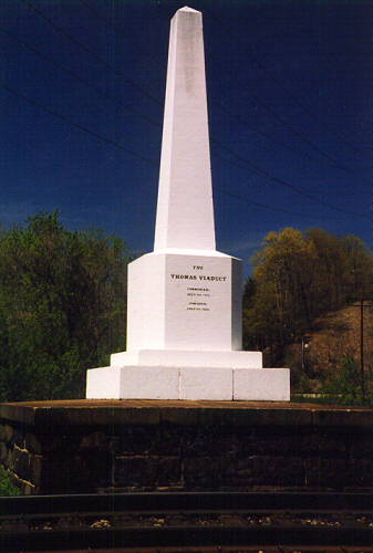
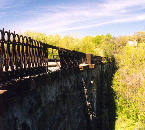
Just north of the Thomas Viaduct stands the approximately 30 foot tall obelisk shown to the left. Inscribed on the stone are the words "The Thomas Viaduct - They said it couldn't be done. Commenced July 4, 1832. Finished July 4, 1835." I guess if you work on holidays, you can accomplish a great deal in just three years; I surmise this was the longest bridge in the USA at the time. It is said to be the only stone bridge in the world that is built on a curve.
I really wanted to get a picture of a train on the viaduct, but back at the museum they said there were only two trains a day running on the route, so I didn't hold much hope. But, while taking this photo of the obelisk, I heard the "ding-ding-ding" bell sound of an approaching train, well CSX locomotive 8507. The resulting picture is shown below.
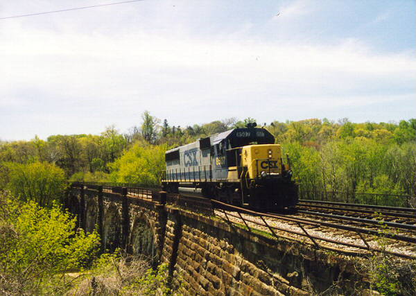
Later, I realized that "two-trains-per-day" rate applies to the old main line: Baltimore to Ellicott City and beyond. The Thomas Viaduct is actually part of the Capitol division, which serves Washington and sees more traffic.
Trees obscure the southern half of the viaduct. Compare this picture with an older photo, and you'll be able to see just how long the viaduct is.
The Thomas Viaduct traverses Patapsco Valley State Park, and a park road now extends beneath it. The photo at right shows the view from this road. To give you some bearings, the obelisk is a short distance up the embankment to the right, and had the CSX locomotive from the prior image been stationary, it would be just visible in the upper right corner of this image.
During the Civil War, large numbers of Union troops were stationed here to protect the viaduct, a bottleneck in the supply line.
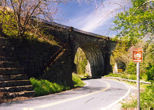
Next, via US Rt. 1, I drove to the southwest side of the viaduct in the Lawyer's Hill area. Parking is very awkward here due to a lack of (legal) spots. I was surprised to find the stairway up to the tracks that you can see in this picture. Note that the old iron railings are finally giving way in places, and some of the granite steps are leaning, so this is not a viable route for anyone who doesn't like heights. I've read that from here you can see the high water marks from the 1930 flood, but I was not able to find them.
At the top of the steps, if you look northeast, this is the view. I think you would be able to see the obelisk, which is on the other side, if the trees were not in the way. It would be located below the house visible on the other side. The trees also block the view of the entire northern half of the viaduct. You might be tempted to walk across the viaduct, but please do not. The clearances are very limited, and trains can surprise you with their speed.
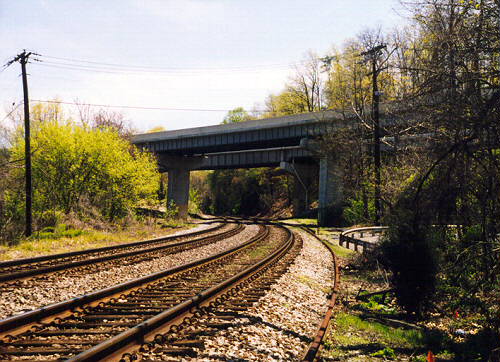
From the top of the stairway, I walked directly across the tracks and took this photo looking the opposite way (south toward Washington). The highway above the tracks is I-895, which connects to the older Baltimore Harbor Tunnel. I've heard the view of the viaduct from I-895 is good, but stopping up there would be illegal (hmm, how slowly can one drive?). The road curving on the right is Old Lawyer's Hill Road.
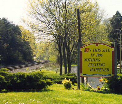
Apparently, not everyone is fascinated with railroads. This sign was posted by the "Hanover Hysterical Society" and can be found near where Hanover Road crosses the B&O (now CSX) tracks. This is about two miles south of the Thomas Viaduct, and is one of the few grade crossings that remain along this route.
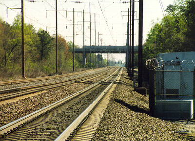
The B&O was not the only major railroad in the area. About two miles east of the B&O's right-of-way, you'll find that of the Pennsylvania Railroad (that's the Hanover Road overpass in the distance). This is now the route used by Amtrak's Northeast Corridor service. This photo was taken looking south from the end of Stoney Run Road, which used to cross the tracks. BWI airport is directly on the other side (to the left in this photo).
Return to main photo project page
Comments? Corrections? EMail intersys@insystem.com
All text and images on this page are Copyright 1999 by Intersystem Concepts, Inc. Permission is granted to copy and reuse the text and images from this page provided 1) no fee is charged, 2) our original copyright is preserved, and 3) we are credited as the source (please include a link back to this page).


