


|
This web page is a request to Rich P. to measure the foundation height of the old remains of the Flambeau Paper Company Railroad Bridge south of Park Falls, below Lower Dam.
I don't know when people might have time and interest to do this for me; I haven't been in Park Falls in 4 years. John B would probably do this, too; so please keep coordinated on this so the effort isn't duplicated. I don't know who else passes by there. Or maybe the local Boy Scouts would make it a project, too? I saw some pictures of theirs on the web from a tour of Pixley Dam last year. Here is the Flambeau River just downstream of the State Highway 13 bridge. |
|
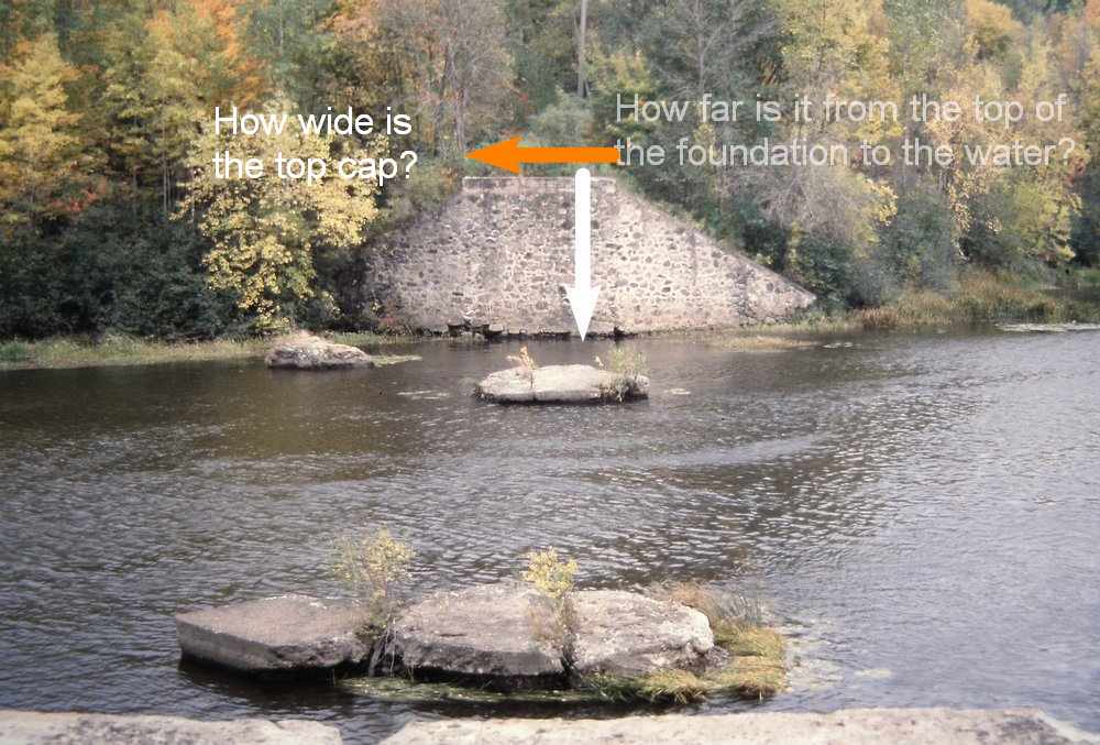
I would like to use my TurboCad to draw it in 3D, next Winter when I am retired. And I don't want to waste time doing that twice, so I really should start with a good height measurement so the drawing starts with a good foundation. The only thing left at this site is the stone foundations. I could use a vertical measurement from the cap to the NORMAL water level, accurate within a half of a foot.
There is no hurry to get this measurements. It could be done from either the north or the south side of the river. I think the height is about 12 feet? A 20-foot tape measure, or a fishing line, should be more than enough to hang over the edge. And measure how wide the top cap is. I would guess 10 feet. |
|
From aerial maps and photos, I determined the horizontal distance between the large abutments / foundations is about 230 feet. For my purposes, I don't need a more precise measurement to confirm that. But if someone had a super laser distance finder, this would be a chance to use it to shoot across. I think the home carpenter version of those is good for only 50 feet? I presume those things work better and more accurately when a reflector or target is placed on the far object. And some golfing or shooting rangefinders would be able to measure that. I can pick the distances of the river footings from the aerial maps. My sketch doesn't need the precision of the original builders. This is just a history project, of a bridge that was removed almost a century ago. I suppose they put a lot of effort in to getting the foundations placed well, but there was room for error on the ends so long as they didn't come up short. The 1910 picture shows a healthy overlap of the girders over the foundations. |
Here's the Link to the Bridgehunters page of about this bridge. I have 4 pictures on it now, including the 1910 picture of all the steel girders.
Bridgehunter Page about the Flambeau Paper Comapny Railroad Bridge
(the Bridgehunter web page is best viewed by an Internet browser, a mobile app only shows the first picture)
|
And the same afternoon that I added a picture, I see more information added by 'Luke': The Flambeau Paper Company Railroad Bridge was removed and relocated in 1938 to the Connor Lumber Co., Presque Isle River Bridge, Gogebic County, Michigan And there was a court case by the State of Michigan about eminent domain to create the Porcupine Mountains State Park in 1947, and one part of the proceedings puts values on the Connor Lumber timber and 3 miles of logging railroad. There was $25,300 shown for the value of the bridge.
I think I see the site of the bridge on Google maps. Find Connerville, Michigan, and follow Camp 4 Grade road northeast of Connerville, there is a bridge over the Presque Isle River.
The bridge length at the Presque Isle River scales only 130 ft long, not the 230ft like the original over the Flambeau River. |
. . . . . to My Main Index Page on the TrainWeb site.
This page was wrote in February, 2019


