Rail Attractions in Halton and Peel Regions

The Regional Municipalities of Peel and Halton lie between Metropolitan Toronto and the Niagara Escarpment. This includes the Cities of Mississauga, Brampton, Oakville, Burlington, and Halton Hills. Between these communities you'll find open space and superb photo locations. Almost every rail line in this area is a busy main line. Unfortunately, this area is experiencing rapid urban development, so get your photos now - the pretty farmer's field you see today may be a shopping mall by next year!
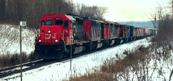
The Halton Subdivision is CN's main route from Toronto westward to Sarnia, Detroit, and Niagara. It runs from MacMillan Yard in Vaughan, west to Georgetown, then southwest to Burlington Jct. The Halwest-Silver section dates from the days of the Grand Trunk, and in CNR days was originally part of the Brampton Subdivision. Silver-Burlington was originally part of the Beeton Subdivision, a secondary line from Hamilton to Barrie. The entire route was rebuilt 1959-1965 into a heavy freight line, as part of an ambitious plan to bypass freight traffic around the Metro Toronto area.
|
CN HALTON |
|
|
11.1 |
Halwest |
|
11.6 |
Bramalea |
|
14.3 |
Peel |
|
15.2 |
Brampton East |
|
15.4 |
Brampton |
|
22.5 |
Credit. |
|
23.5 |
Georgetown |
|
24.1 |
Silver |
|
26.4 |
Stewarttown |
|
28.0 |
Speyside |
|
32.3 |
Mansewood |
|
34.3 |
Milbase |
|
39.5 |
Ash |
|
43.1 |
Tansley |
|
49.5 |
Burlington West |
The Halton Subdivision handles most of CN's freight traffic through the Toronto area (some Montreal-Oakville-Hamilton trains bypass Mac Yard via the Oakville Sub). There are GO Trains between Halwest and Georgetown on weekdays; and VIA service daily Halwest-Silver. The Goderich-Exeter Railroad, a Railtex short line which operates the CN's Guelph Subdivision, runs a daily turn from Silver to MacMillan Yard. In all, the Halton Sub is seldom quiet for very long.
The Halton Subdivision passes through industrial environs from Halwest to west of Brampton. Then, there is open countryside most of the way to Burlington. The scenery in the Georgetown-Milton segment is wonderful. There are superb bridges over deep river gulleys at Credit and Stewarttown. The bridges are single-track, which makes for interesting meets and keeps the radios busy.
Southwest of Milton, the scenery is still rural...for now. Burlington is expanding to the north, and Milton is expanding to the south, and soon the twain will meet.
BRAMPTON - The old Grand Trunk depot still stands and is in use as a GO/VIA station. The station is a good trainwatching spot, with a good shelter and signals visible in both directions. Fencing is a pain at the depot but the crossing to the west is OK.. The former CP Owen Sound Subdivision, now a short line, crosses at grade immediately west of the depot.
West from Brampton the route is ruler-straight. In good weather you can usually see two sets of block signals down the line. The line rises to a crest at Mount Pleasant (MP 18), where Highway 7 crosses on a high overpass, and then descends a fairly steep grade towards Georgetown. The Highway 7 bridge is a decent vantage spot, albeit a little noisy. Suburbia ends at the overpass, with much nicer scenery from there to the west. For a decent level crossing take Heritage Road north from Highway 7.
Brampton has good public transit connections from Toronto, as well as VIA and rush hour GO service, so it's a good choice for a trainwatching spot if you are depending on public transit to get around while visiting Toronto.
MP21 - One of the best spots on the Halton Subdivision is at the level crossing on Winston Churchill Boulevard north of Highway 7. Winston Churchill is a major north-south artery which intersects Highway 7 in the hamlet of Norval. For some reason it is named Adamson Street within Norval town limits, so watch the street signs carefully!
There is a good laneway to park in. The north side has a very wide right of way, giving good angles on cloudy days or early and late in the day, when the light favours shooting from the north side. There is a steep grade eastwards from Credit to this spot, trains held at the single track section over the Credit River must work hard up this stretch. The view west from the crossing is superb for telephoto shots. Walk westward from the crossing along the south side embankment and you'll come to a really nice hilltop overlooking the Credit River trestle.
GEORGETOWN - The roadbed of the former CN Beeton Subdivision runs northwest out of Georgetown Yard. Original GTR station dating from the 1850's still stands at Georgetown, but fencing makes the site unappealing. GO trains layover in the yard at Georgetown. There are a couple of good overpass shots to the east and west of the depot.
SILVER - CN's former Guelph Subdivision, now the Goderich Exeter Railroad, diverges at Silver, a short distance west from Georgetown station.
STEWARTTOWN - there is a pretty bridge over the Bronte Creek, with good parking at the west end of the bridge. Take No 15 Sideroad west from Trafalgar Road to the 6th line. The CN has a number of roadway trails paralleling the tracks in the Stewarttown-Speyside area, good for parking and even better for walking.
SPEYSIDE - A nice level crossing with room to park on the 5th line, north of No. 10 Sideroad.
MP 30.0 - The nicest spot on the entire Halton Sub is found on the 3rd Line, north of No. 10 sideroad. There is a long winding view to the east and good elevations to the west with the Escarpment in the distance. This is the ruling grade and eastbounds have to put on a show here. There is a nice pull-off area to park in, right next to the block signal. This is a popular gathering spot for railfans, so expect to have company. This site is technically on railway property and there is an occasional police presence. CN seems to tolerate well-behaved fans at this location, but individuals found doing dumb things are treated accordingly. Stay off the tracks and be mindful of relationships with the railway.
|
|
MILBASE - South end of the passing track through Milton, at this point the line reverts to single track. Entering Milton, the line proceeds on a high embankment, which makes it difficult to get decent photos. Tracks cross under the 401 just east of the Highway 25 interchange, then turn west to cross over Highway 25 just south of the 401, following Steeles Avenue, then turning south beside Bronte Road (First Line). At this point the line curves south. There are a couple of landmark bridges, not particularly photogenic but painted with an attractive Town of Milton logo - good for a "we are here" shot.
The line crosses the busy CP Galt Subdivision by Bronte Road south of Steeles Avenue. This isn't a great place for photos but it's a nice place to sit and watch, both lines are busy all day long.
From Derry Road (runs e/w) to roughly Appleby Road (n/s, south of Highway 5) the tracks run southwards, giving good photo angles all day long. No poles or other obstructions, good photo angles, Niagara escarpment in the background in morning light. First Line is the closest parallel road southwards out of Milton, Tremaine Road (County Road 22) is the next parallel road to the west.
The pretty right of way south of Milton is a borrowed-time zone. CN has announced plans to build a major intermodal facility in the area. Already there are signs that the farms in the area are closing down. This development is being fought tooth and nail by local residents. Check out their web page for details.
ASH - Double track resumes westward (southward, really) at this point. Coming south, First Line ends at Lower Base Line Road, turn west at that point, you will cross the tracks, then reach Tremaine Road (County Road 22). Turn left (south). Tracks cross again, watch for 1 Sideroad (Burnhamthorpe Road) to the west. This is a dead-end road with an unsignalled level crossing. The sideroad is an excellent place to park, walk south along the right of way from the crossing to reach some excellent low cuts, and eventually Tansley. Line is open and accessible in this area. Very pretty spot to photograph trains or just hike around.
TANSLEY - Single track over the Bronte Creek bridge - deep river gorge, marred by a power line crossing overhead. Highway 5 (Dundas Street) overpass is wide, has good shoulders, excellent view to south. Level crossing on Appleby Road with good view northwards. South from Appleby Road, you are back into civilization. New subdivisions and light industry are erupting at lineside from there to Burlington. The trackside is still open for photos but background is not wonderful in that area. Level crossing on Upper Middle Road.
Picnic area (Milcroft Park): take Upper Middle west from Appleby, first right north off First Middle is Country Club, take it to Milcroft Park Road, turn right and watch for the baseball diamond and light towers on the right side...much open area and washrooms.
|
CP GALT |
|
|
12.4 |
Dixie |
|
15.4 |
Cooksville |
|
18.1 |
Erindale |
|
20.3 |
Streetsville |
|
21.2 |
Streetsville Jct. |
|
23.1 |
Meadowvale |
|
31.2 |
Milton |
|
39.2 |
Guelph Jct. |
Continuing from Dixie, the Galt Sub runs roughly parallel to Dundas Street to Cooksville, then cuts northwest to Highway 401 near Streetsville. West of Streetsville the line parallels Highway 401 westward through Milton to Guelph Junction, atop the Niagara Peninsula.
The route through Missisauga is now suburban and industrial right through from Toronto to west of Streetsville. The open countryside in this area is quickly disappearing; Streetsville to Milton is just one big construction zone these days. The Milton-Guelph Junction portion is the line's jewel; fans have been coming here since steam days to watch trains battle the steep grade up the Niagara Escarpment.
COOKSVILLE - There are level crossings south of Dundas, between Dixie and Cawthra Roads. Check out Znidar Brothers on Middlegate Road, they are a dealer in industrial locomotives and run switching operations in the Toronto area. Occasionally there will be a critter or two on hand at their facility.
STREETSVILLE - The Galt Sub crosses the Credit River east of Streetsville in fenced parkland. At Streetsville Jct there is a wye and a junction with the former CP Owen Sound Subdivision, now the Orangeville Brampton Railway, which runs north to Orangeville. West of Streetsville Jct, the Galt Sub parallels Derry Road to Milton in industrial and open farmland.
HORNBY - CP's new Expressway Service Intermodal terminal is found here. Expressway trains on the Hornby- Montreal and Hornby-Detroit runs originate and terminate here. West of the terminal is the well-known "Hornby Dip", where tracks descend a steep grade and then rise again into Milton. The level crossings in the back roads between Trafalgar Road and James Snow Parkway offer some pretty shots.
MILTON - The line crosses under the CN Halton Sub at Milton. This is a busy spot, but not particularly photogenic, as the Halton Sub crosses on an embankment with steep slopes. The west slope of the CN bridge, however, is a good place to photograph morning eastbounds on the Galt Sub, with the escarpment as backdrop.
CAMPBELLVILLE - West of Milton, the Galt Subdivision ascends the Niagara Escarpment. This is a beautiful area, with the tracks winding around the cliffs on the escarpment through the Milton Gap. Follow Steeles Avenue west from the CN line overpass to find some good photo spots along the escarpment. There are also good spots accessible by taking the concession roads south off Campbellville Road, which runs parallel to the 401 highway on the north side.
Kelso Conservation Area, west of Milton, is a good place for the family, with picnic and swimming areas, good access to the tracks, and a good pioneer museum.
GUELPH JUNCTION - This is the junction with the Hamilton Subdivision - Southern Ontario's version of Saluda - and the former Goderich Sub to Guelph. The latter is now run by the Ontario Southland Railway, whose vintage Alco power ties up at the Junction. Guelph Jct is also the terminus for GO Transit trains, which deadhead to and from Milton for their runs to Toronto. Access road to the Junction, Guelph Junction Road, runs north off Campbellville Road, a little west of downtown Campbellville.
The Galt Sub is a very busy line from Lambton westwards. Roughly 30 through freight trains use the line in a day, plus industrials and way freights. GO Trains run between Union and Milton on weekdays. Most Toronto-Hamilton-Buffalo trains run west to Guelph Jct, then south to Hamilton, and a Hamilton Turn runs London-Guelph Jct- Hamilton via the Hamilton Subdivision. The OSR runs weekdays (and recently, frequently on Saturdays too!), with one and sometimes two trains heading north in the morning and returning late in the afternoon.
A local oddity: on the Galt Sub, train numbers do not correspond to track direction. Montreal-Toronto-Detroit traffic is considered as east-west, so westbounds normally have odd numbers, eastbounds have even numbers. HOWEVER Toronto-to-Buffalo trains are considered as North-South, so 'westbounds' have even numbers and 'eastbounds' have odd numbers. And since the west-to-north wye was built at West Toronto, Windsor-Toronto-Winnipeg trains on the Galt Sub carry their transcontinental numbers. The result: Buffalo-bound train 418 will be running westward, Montreal- bound 152 will be heading eastward; and Winnipeg-bound 219 runs eastbound. Confused?
Map
of the Galt Sub GO Transit service - by Tony Borek
CP Galt Subdivision
from Dixie to Bathurst Street
CP
Galt Subdivision West of Guelph Jct (Bill Miller's Web Site)
|
CN OAKVILLE |
|
|
11.5 |
Port Credit East |
|
12.8 |
Port Credit |
|
16.7 |
Clarkson |
|
17.6 |
Park Royal |
|
19.3 |
Ninth Line |
|
20.6 |
Oakville Yard |
|
21.4 |
Oakville |
|
22.1 |
Kerr Street |
|
24.7 |
Bronte |
|
27.1 |
Burloak |
|
27.9 |
Appleby |
|
30.5 |
Burlington East |
|
31.5 |
Burlington |
|
32.0 |
Burlington West |
|
32.2 |
Aldershot East |
|
34.6 |
Aldershot |
|
35.2 |
Aldershot West |
|
36.9 |
Bayview |
|
37.3 |
Hamilton Jct |
|
38.9 |
Hamilton Yard |
|
39.3 |
Hamilton |
There are plenty of places to access the tracks. The right of way is straight and open, making photography easy, but the surroundings are pretty mundane. The area close to Aldershot is still fairly natural, but otherwise count on suburbs and industrial areas all along the right of way.
The Oakville Sub is mostly three or four tracks. It is very busy, with plenty of GO and VIA traffic. There is some freight activity. CP has trackage rights west of Canpa. Switching yards are found at Port Credit, Oakville, and Aldershot.
CLARKSON - Ontario Southland switches the petroleum refineries here.
OAKVILLE - The Ford Plant in Oakville has a large yard facility with both CN and CP switching crews. Some yard power is stationed here.....and it's all GM power!
ALDERSHOT - Aldershot Yard is an important setoff/lift yard - many through freights swap blocks here.
Some of CN's through freights, especially those with auto traffic, use the Oakville/Kingston Subdivisions via Toronto Union Station rather than bypassing the city on the normal Halton-York Subdivision route. This time-sensitive traffic may show up at any time, even in the middle of the rush hour!
CP has trackage rights on CN from Canpa to Hamilton Jct, but CP's operating practices seem to vary by the minute. The Oakville Sub is a much faster, shorter routing than CP's mountain-grade line via Guelph Jct, but CN's route costs more and freights take second priority when GO trains are running thick and fast. CP vaccilates between its own line and CN's, with CN chosen mostly when trains get too heavy for the steeper CP line. In addition to Toronto-Hamilton movements, CP has moved Toronto-Chicago trains over the Oakville Sub when its own line is stretched to capacity. Recently, upgrades to signals and sidings on CP and a new interchange at Melrose (west of London) has ended this practice. CP still detours over this line when its own line is not available.
CN Oakville Subdivision - Bathurst Street to Dixie
|
CP OWEN SOUND |
|
|
0.0 |
Streetsville Jct |
|
2.1 |
Meadowvale |
|
7.5 |
Brampton |
|
12.2 |
Snelgrove |
|
17.1 |
Cheltenham |
|
19.8 |
Inglewood |
|
24.0 |
Forks of Credit |
|
26.6 |
Cataract |
|
29.7 |
Alton |
|
31.4 |
Melville |
|
34.6 |
Orangeville |
Losing the CP "Moonlight" - the venerable CP Orangeville-Lambton freight run which dates back to the turn of the century - was a loss, but the good news is the OBRy now runs a daylight Orangeville-Streetsville roadswitcher on Tuesdays and Thursdays. It leaves Orangeville in the morning, interchanges with CP in Streetsviille, and then returns to Orangeville.
Passenger excursions have begun operating on weekends - details can be found at the Credit Valley Explorer website. This route is a scenic delight and the trip is well worth the fare.
STREETSVILLE JCT - is on Ontario St, which runs west off Queen St 3 blocks south of Britannia. The actual junction switch is just north of there (railway west). Another way of accessing is from William St which runs north/south parallel to Queen between Queen and the Galt Sub.
The old Credit Valley Railway station, now a private residence, still stands at the corner of Ontario and William.
The Owen Sound sub crosses Queen St (actually it may be named Mississauga Rd by then) north of Britannia. There's a small yard and a bulk transfer facility.
MEADOWVALE - One major customer which receives much switching attention is the Serviplast plant. Serviplast is on Creditview Road (formerly 3rd line). Head east on Britannia from Streetsville, turn left onto Creditview at the Loblaws shopping plaza. Or, take Argentia east from Mississauga Road.
There are some nice curves south of Brampton, in the Chinguacousy Road - Steeles Avenue- Churchville Road area.
FORKS OF CREDIT/CATARACT - The Forks of Credit area is extremely scenic; it's a prime recreation area for Torontonians, offering hiking and crosscountry ski trails in rugged hilly scenery. Take Highway 10 north from Brampton and watch for the Forks of Credit Road on the left. It leads to the famous Forks trestle. There is a Provincial Park on the east bank of the Credit valley.
The former Elora Subdivision, now abandoned, runs westward from Cataract..it's a lovely hiking trail. Melville is the former junction with the original line to Bolton. The line twists through prettty hills all the way to Orangeville.
Credit Valley Connection - Bolton to Orangeville
![]()
Copyright © 1996, Paul Cordingley
Revised - May 3, 2005
url:http://www.trainweb.org/railsintoronto/halpeel.html