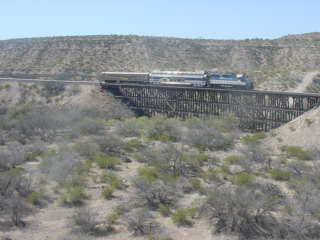
Our train left the city of Globe and headed south towards Bowie, Arizona.
US Highway 70 followed our route to just east of Safford.
The Santa Teresa Mountains.
Looking back up the rails from where we had been.
Near Cutter, Milepost 1213.5.
The Casino Station platform at Milepost 1214 serves the excursion train passengers who want to use and stay at the Apache Gold Casino Resort, where the Arizona Eastern train comes to its eastern terminus.
The desert floor along this part of our route.
My favorite type of cacti are plentiful on the hills here.
Saguaro cacti stand against the blue sky.
Our train took another curve on this line.
The view north.
A southward view.
Looking behind.
Nearing San Carlos.
The water tower still stands at San Carlos, which is the largest community in and the seat of government for the San Carlos Apache Indian Reservation. Originally known as Rice, it is a regional trading centre and has a population of about 4,000. The community is also home to the world's largest deposit of peridot, the August birthstone.
Mt. Graham to the southeast at this point of our journey.
A view looking east at an interesting landscape.
We crossed this bridge then Bart ran to remind the crew that was a runby location so we reversed and detrained.
Photo runby at Milepost 1194.
The Santa Teresa Mountains to the southwest.
Gila Mountains with Gila Peak at an elevation of 8,829 feet.
San Carlos Lake which is backed up by the Coolidge Dam.

The final photo runby of the day at the curved trestle at MP 1187.
View of the curved trestle as we headed south towards Bowie.
The cut after we had passed through.
Views along our route today.
Passengers enjoying the dome car.
Gila Peak to the north.
Another view looking back.
Views looking to the south.
Looking north.
Looking north at the Gila Mountains.
Our route passed through many cuts as we made our way towards Bowie.
The Gila Mountains to the north.
The Santa Teresa Mountains to the southeast.
The Pinal Mountains to the west.
The old station foundation in Bylas.
Agricultural interest abounds in the Gila River Valley.
The Safford Mine may someday have rail service built so the ore could be taken to the smelter in Miami, Arizona.
Passing through Pima.
The late afternoon sun lit the rails of the Arizona Eastern.
Mt. Graham at 10,720 Feet.
The former Southern Pacific station in Safford built in 1928.
Heading away from US Highway 70.
Gila Mountains.
The Pinaleno Mountains to the southwest.
Another view of the Gila Mountains.
Freight cars from a derailment.
The sun had set on a fantastic day of railroading, but we still had the miles to Bowie before our trip would be over.
Some post-sunset views as we made our way to Bowie.
Night took hold the rest of the way. The Arizona Eastern was there switching cars and we had to wait for them to clear before we could proceed to the grade crossing and all detrain from this wonderful rare mileage excursion. We all said our goodbyes until tomorrow and returned to our cars.
Once we all were off and in our cars, our train still blocked the only grade crossing in town and before he could move out of the way, a Union Pacific westbound freight blasted through Bowie. Our train moved just before the freight had cleared and we drove back to Safford for the night, stopping at Arby's there for me and at McDonald's for Randy and Marie. I finished the story of the trip over here then called it a night.
4/6/2009We met and loaded the car before Randy, Marie and I went and had the hotel's continental breakfast then stopped at Circle K again before making a final stop in Safford.
A morning view of the Safford station before we drove east on US 70 to Duncan for our Rare Mileage Trip on the former Southern Pacific Clifton Branch.
| RETURN TO THE MAIN PAGE |