
Wildflowers dot the trail edge as we exit east of Bessemer, MI, on
6/09/23. |

The left fork leads to a small trailhead on US Hwy #2 to the left of
the distant signs (I camp about 1/4 mile further east off Hwy #2).
The right fork continues on to Ramsey (1 mi).
|

The Ramsey, MI, keystone arch bridge is 57 feet above the Black River
and was built in 1891 by the Chicago and Northwestern Railway Company.
The trail crosses on this bridge. 9/01/17 photo.
|

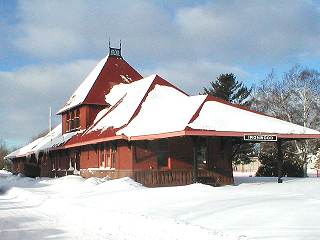
Today's photo run started at Hobby Wheel and headed west. This
is downtown Ironwood with the ex-CNW depot
in the distance. The tan building is the Ironwood Post Office.
|

Just in case you thought Bambie was a rare sighting; here's 2 more
deer in Ironwood nearing Hurley. They're everywhere!
|

The Montreal River is the border with WI on your left and MI on your
right.
There's a Hurley city street under the bridges on the left bank.
|

Approaching downtown Hurley, WI., we see an ATV coming towards us and
best restaurant in Hurley at the building near the center power pole.
|

On this 9/12/17 trip I continue west of downtown Hurley about 3 miles
to Montreal, WI. This bridge is the Soo Line crossing over the CNW.
SOO continued west to Mellen, WI, while the CNW went NW to Ashland, WI.
|

This is recreational Trail 15 that takes us about 2 miles to Montreal,
WI. 7/29/09 photo. |


