


After a good night sleep I woke up at 5:25 AM and got dressed.

The first picture of the morning was the landscape west of Williams, Arizona as we rode on the Williams Junction-Crookton line relocation, which reduced grades and curvature and was completed in 1960. I went to the lounge car and rode there until breakfast at 6:30 AM.

A beautiful view as we traversed the line relocation. Before the cutoff was constructed, the mainline went through Ash Fork, which is south of here.

Near Double A.

I love this part of northern Arizona.

A beautiful view near Eagle Nest.

A hill to the north.

An oil plant to our south.

A view looking south as we neared Seligman.

Seligman, Arizona.

The "S" on the hill is for Seligman.

West of Seligman, the mainlines split with a BNSF stack train heading east.


Buttes abounded along our route.

A mesa to the north.


Looking north, after which I went to the dining car for cereal and sausage patties.

A caboose used as a cabin out in the middle of nowhere.


The mainline splits as we closed in on Nelson Tunnel.

The train was about to enter Nelson Tunnel at Milepost 457, the only tunnel on the Santa Fe mainline in Arizona.

We then entered Crozier Canyon.


Crozier Canyon.


The Southwest Chief was nearing Kingman, Arizona, our next stop and crew change.

We reached the greater Kingman area.

Approaching downtown.


Kingman is on Route 66 and there is plenty of memorabilia around.

The Santa Fe Kingman station built in 1907. A crew change occurred here and a friend of mine, Dave Arthur, was the new Amtrak Conductor who is excellent, hard-working, knowledgeable and great in dealing with the public while doing his job.


Santa Fe 4-8-4 3759 built by Baldwin in 1928 on display at Locomotive Park in Kingman.
We then entered Kingman Canyon.


Kingman Canyon.


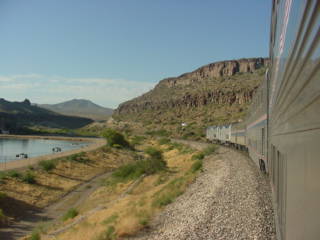
Views as we dropped from the canyon on the way to the Colorado River at Topock, Arizona.

The Southwest Chief as reached Topock and the bridge across the Colorado River and into California.

The former Santa Fe Railroad bridge built in 1945.

The Needles mountains, that the City of Needles, California, is named after.

The front of the Southwest Chief is in California while I was still in Arizona for a few more seconds.


The Colorado River.

Park Moabi.

The desert comes right up to the edge of the Colorado River.

The Colorado River is the state line between Arizona and California.

The Southwest Chief reached its stop at Needles.


